4 Boys


Caution! We do not provide turn-by-turn directions in our GPX files. Those are auto-generated by your bike computer and are usually less than 70% accurate. Learn more.
For help loading a GPX file onto your bike computer, go here.
DownloadHighlights & Remarkable Spots
Ben's Trail / ~ Miles 0 to 2
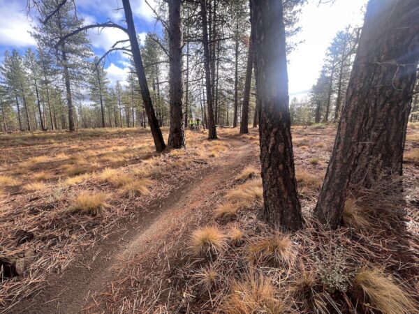
Ben’s Trail is one of the first trails put into the Phil’s Network. Do you know who it is named for? Do you know that it originally was NOT a mountain bike or hiking trail, but that it had another purpose? Give a listen to this podcast and this podcast to get answers to these questions and learn more about the history of Ben’s Trail.
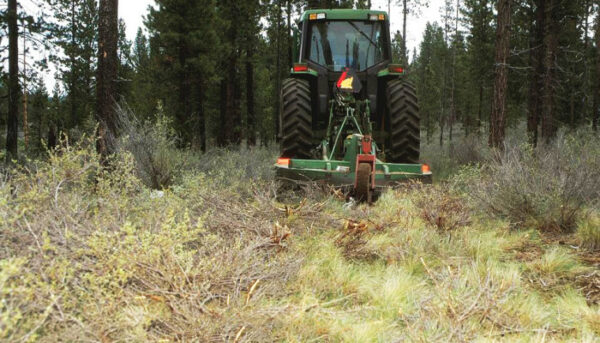
West Bend Thinning Project / ~ Miles 0 to 7
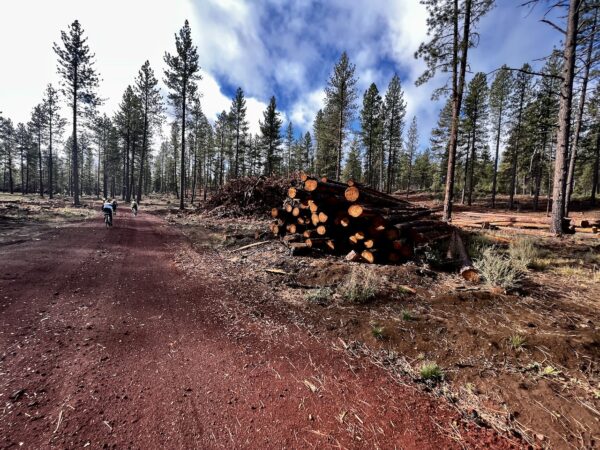
Along this section of trail you are riding through the West Bend Project, a 15-year forest management effort that includes tree thinning, brush mowing, and controlled burns. The project received Congressional funding through the federal Collaborative Forest Landscape Restoration Act. There are only 20 such demonstration sites nationwide. The goals of the project are to: restore forest ecosystems, reduce the potential of high-severity wildfires, and provide economic and social benefits to local communities. For more information, see the resource page in the right sidebar (desktop) or towards the bottom of page (mobile).
Public Land Stewards / ~ Mile 7.6
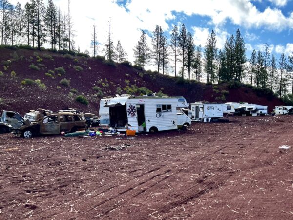
Public Land Stewards, an independent non-profit organization funded by donations, serves to safeguard user access on public lands. The organization hosts clean-up events during which volunteers gather and remove unwanted cars and other trash from public lands. This helps the Forest Service, which doesn’t have funds or resources for such efforts. Public lands belong to all of us, so consider donating money or time to the Public Land Stewards. [Public Land Stewards]
Sunriver / ~ Miles 18 to 19.5
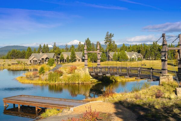
The area now know as Sunriver was originally a lake bed. The lake dried and turned into a meadow, which became a popular meeting place for Native Americans. In 1943, the US Army established Camp Abbot on the meadow and used it as a training ground. Closed after D-Day in 1944, most buildings were razed except for the Officer’s Club, which is now the “Great Hall.” In the mid 1960s, the land was developed into a luxury resort and residential community. Today the resort is known for its golf courses and recreational vacation rentals. [Wikipedia]
Wood Deck Bridge / ~ Mile 21.5
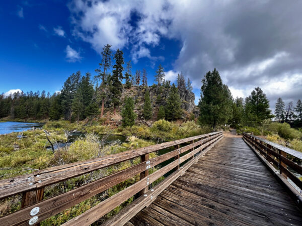
In 1916, the Shevlin-Hixon and the Brooks-Scanlon mills opened in Bend. Soon railroads and the river were used to access the forest and bring ponderosa pine to the mills. Logs were floated down the river to this location from as far away as present-day Wickiup Reservoir, loaded onto trains, and then hauled to the mills via haul roads (see the Old Haul Road Point of Interest below). The logging process had a significant impact on the river: natural, woody material was removed from the river and riverbanks were damaged, harming riparian areas and fish habitat. [On-site Kiosk]
Deschutes River / Miles 21.5 to 28
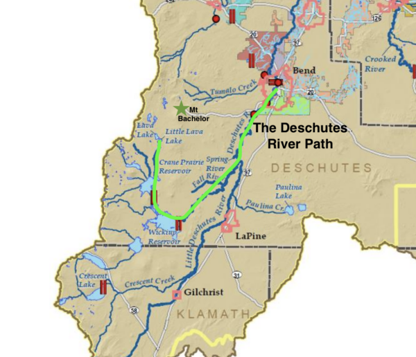
From here, the Upper Deschutes River flows north towards Bend. Originating at Little Lava Lake in the Cascade Range, about 16 miles due west of here, the river supports over 100 species of plants and trees, as well as fish species of Redband Trout, Brown Trout, and Whitefish. [On-site Kiosk]
This section of river is classified as Wild & Scenic, meaning that it has been protected by Congress due to its remarkable scenic, recreational, geologic, fish and wildlife, historic, and/or other similar values. Despite its protected designation, the river’s ecology is at a tipping point, with steep declines in fish, wildlife, and vegetation. We must act now before it is too late. Take a moment to learn more on the Deschutes River Conservancy website.
Benham Falls / ~ Mile 22
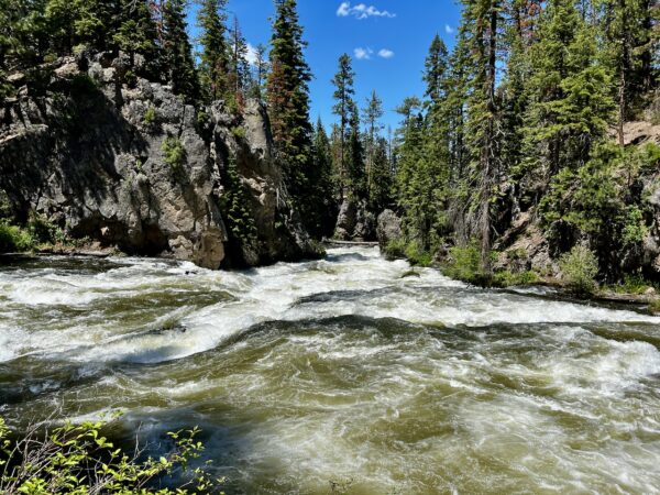
You will need to detour slightly off-route to access this overlook. Benham Falls is perhaps the most notable of the turbulent class V rapids on the Deschutes River as it rushes towards the southwest of Bend. The falls reside in an area where a large field of lava solidified and formed a narrow canyon that squeezes the Deschutes River. Around 1885, J. R. Benham attempted and failed to file a land claim near this area, though the falls were later named for him. [Visit Bend]
Lava Flow / ~ Miles 21.5 to 28
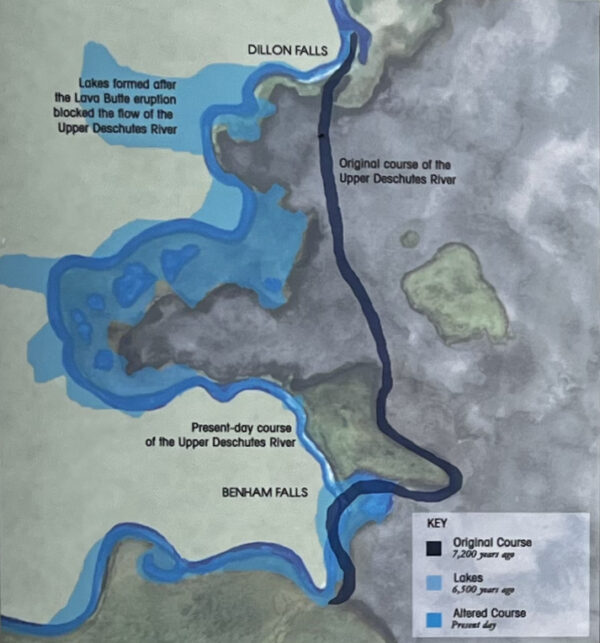
Do you see the large lava flow to your right? The Upper Deschutes River used to run where the lava flowed. Over 7000 years ago, the Lava Butte eruption buried the old channel of the Upper Deschutes River under more than 100 feet of lava. With the flow of the river still running north, this entire area filled with water. Known as Benham Lake, it covered over 15 square miles. With Benham Falls at it northern most point, the lake extended all the way south to LaPine Start Park (see the Big Red Ride Guide). When the lake filled nearly two million years ago, it found an outlet across a low divide in an ancient lava dome. Today, the river continues to cut into this dome at Benham Falls. Over the years, the river slowly downcut at Benham Falls. The lake became smaller until it finally disappeared. [On-site Kiosk]
Ryan Ranch Wetlands / ~ Mile 25.2
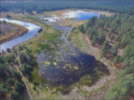
This 65-acre slough was first homesteaded in the 1890s. A berm built in the 1920s prevented the river from flooding the slough and sustained the site as pastureland. Over time, the invasive reed canary grass outcompeted native wetland species and spread across the basin. Restoration in 2018 now allows the river to actively flood the slough, which directly benefits native rushes and sedges. Remember: “Sedges have edges, rushes are round, and grasses have knees that bend to the ground.” [On-site Kiosk]
Old Haul Road / ~ Miles 25.5 to 26.5 and 27.5 to 28.5
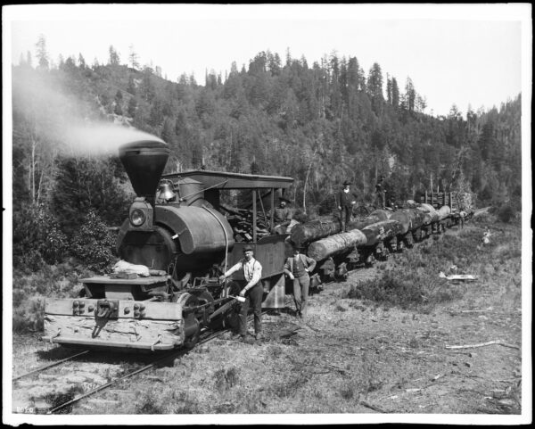
These miles follow along the Old Haul/Shevlin-Hixon Road. This historic railroad logging route was used to transport logged trees to the Brooks-Scanlon and Shevlin-Hixon mills, which were located along the Deschutes River near Bend’s current Old Mill shopping area. The rail lines were used in place of the river on these segments due to the prevelant cascades and falls, which complicated transport by water. [Old Mill District]
Mother Nature / ~ Mile 28
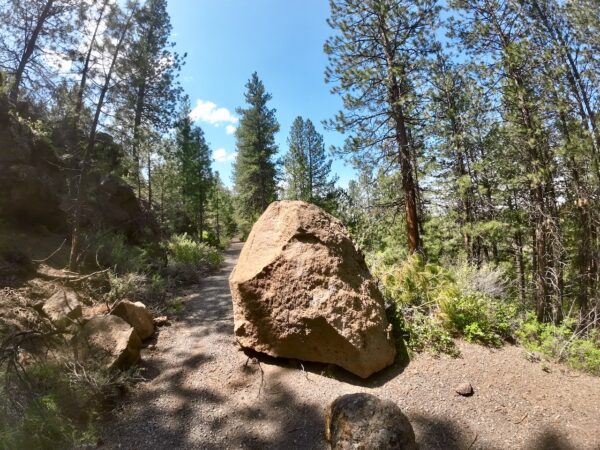
This rock is evidence of the incredible forces of Mother Nature. In the winter of 2022, this boulder (a weight of probably several thousand pounds) was ejected from the hillside to the left. We tend to think of nature as static and unchanging, but this is not so. Rocks, creeks, and tectonic plates are always shifting and moving. Sometimes these changes occur violently with massive thunderstorms or volcanic eruptions; other times just with a simple freeze-thaw cycle.
Tethrow Resort / ~ Miles 33 to 34.5
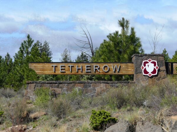
At one point, this high-end resort and golf community was a struggling endeavor that was on the brink of failure. As reported in 2009, “Only 59 of 302 plots have sold and just ‘a handful’ of homes have been built on them. The master developer, Arrowood Tetherow, had to unload most of its residential lots, plus the property where it planned to build a hotel and the golf course itself. Now it’s getting pressure from another one of the developers, Virtual Realty Enterprises of St. Louis, which has filed a notice of default for failure to pay $12 million on an $18 million line of credit.” [Bend Bulletin]
When We Like to Ride This
This is a great “go to” ride in late fall and early spring in that it is rideable almost all year, the elevation never exceeds 4500 feet (excluding the climb to the top of Lava Butte, elevation 4970 feet). The spring and fall colors are drop dead good! We are not so keen on this ride during the summer as there are a lot of other user groups on the trails and bike paths. It just feels a bit too busy for biking.
Terrain & Riding
What captivates us about this route? It’s a cornucopia of cycling delights, a symphony of diverse terrains that will leave you yearning for more. From the thrill of drop bar gravel riding to the enchanting allure of red cinder roads, you’ll traverse an array of surfaces that will keep your wheels spinning. And let’s not forget the paved bike paths, the grey dirt roads, and the historic old railway double-track, each offering a unique charm of its own.
As your tires grip the earth beneath them, a mesmerizing tableau unfolds before your eyes. Towering ponderosa trees grace the landscape, their majestic presence casting dappled shadows on your path. Wetlands and meadows come into view, painting a vivid picture of nature’s diversity. And then, there is Benham Falls, a roaring waterfall, a spectacle that demands a pause for admiration and a photo to capture the moment. But the pièce de résistance is the Deschutes River, with its picturesque stretches that evoke a sense of serenity as you pedal alongside its tranquil waters.
Fear not the single-track, for it’s rated mountain bike easy to low intermediate. If you possess solid technical handling skills, you will conquer it all. A hint of adventure awaits those less experienced, with only a smidgen of hike-a-bike required—no daunting sections of more than 30 yards or so to impede your progress.
Consider this ride as your passport to seasonal perfection from the early blooms of spring to the golden hues of autumn. With just the right amount of elevation change, you won’t find yourself battling the extremes of finger-tingling cold or dripping sweat. Instead, you’ll pedal at a comfortable pace, savoring the essence of Central Oregon and Bend.
The Start
Phil’s Trailhead.
Food & Water
- ~ mile 18 / Sunriver Marketplace (Will need to detour by ~ 1 mile. Lat/Long: 43.898187, -121.418150)
Route Notes
The route has 5 single track sectors, the shortest at 0.5 miles and the longest at 3.4 miles, that are rated easy to intermediate for mountain bikes. There are also 5 gravel sectors, the shortest at 0.8 miles, the longest at 5.9 miles.
We made a major revision to the route and did a complete update of the Ride Guide in October 2023. The route is now a proper loop. We did eliminate the leg to Lava Lands Visitor Center. But you can still find that in the Lava Boys ride.
Route Options
If you are looking for a longer ride (48 miles, 2900 feet of gain) check out Lava Boys. Lava Boys is “close” to the original version of 4 Boys.
Love Where You Ride! Learn More
![]() This route includes a significant amount of single-track trail. The Central Oregon Trails Organization (COTA) manages and maintains these trails for riding. Like Dirty Freehub, they are a non-profit. We encourage you to give back with time, talent, or money to your local riding organization. It is easy to forget that trails and routes require your on-going love and support.
This route includes a significant amount of single-track trail. The Central Oregon Trails Organization (COTA) manages and maintains these trails for riding. Like Dirty Freehub, they are a non-profit. We encourage you to give back with time, talent, or money to your local riding organization. It is easy to forget that trails and routes require your on-going love and support.
Videos
The Ride! 4 Boys
A quick 2-minute video of what to expect on your ride!
Trail Etiquette (Horses, Hikers & Bikers)
Whether you like to hike, bike, or ride a horse, we all want to enjoy our trails safely. Learn how to share the trail respectfully!
Act Now to Save the Deschutes River
A 2-minute video detailing the threats to the river and what we can do to help. Get educated and advocate!
Podcasts
Thinning, Mowing and Fire (Making our forests healthy again!)
“What happened here?” That is a common reaction many have after seeing the immediate impact of the tree thinning and forest mowing work in the Phil’s network of trails. In this podcast, we talk with Melanie Fisher from the Deschutes Collaborative Forest Project to discuss [...]
Ryan Ranch Meadows
Ryan Ranch area was homesteaded in the 1890s. In the 1920s a berm along the Deschutes River was constructed to keep the river from flooding valuable pasture land. Prior to this, the area historically functioned as an emergent freshwater marsh that was connected to surface flows from the [...]
Be Informed!
Keep it Local! Learn More

Ridden and Reviewed by:


 Behind every route is scouting, mapping, storytelling, and a whole lot of pedal power.
Have you ridden this route? Got a question? Join the discussion!