As you ride through the Phil’s system of trails, you will notice ongoing tree thinning work or tree thinning that has occurred recently. This is all part of the West Bend Project, a 15-year forest restoration project to improve forest health and to create a buffer protecting our communities from wildfire.
A combination of historical factors, including widespread logging and aggressive fire suppression, has left behind an unhealthy forest with even-aged, densely packed trees that are vulnerable to fire, insects, disease, and drought.
Note not all forests are the same, and they must be treated differently. What works for forest management in the East Cascades forest may not, and is not, an appropriate forest management tool for the Oregon Coast forests.
Here’s a podcast with Melanie Fisher from the Deschutes Collaborative Forest Project to discuss the ongoing work to restore the forest back to a healthy ecosystem that supports wildlife and recreational use and is wildfire resistant.
The Project
- Collaboration. This project is the result of the collaborative efforts of Deschutes National Forest Service, The Deschutes Collaborative Forest Project, the Oregon Dept of Fish & Wildlife, the Oregon Department of Forestry, The Nature Conservancy in Oregon, OSU, and others.
- Marking.In general, Orange paint marks trees to stay, blue paint marks trees to be cut.
- Thinning. Removal of marked trees via mechanized methods. Thinned to 35 to 65 total trees per acre, with 10 – 20 being larger ponderosas.
- Mowing. Cutting the underbrush of the forest floor.
- Burning. After the initial thinning and mowing treatments, prescribed fire will be used as the last stage of restoration and ongoing maintenance.
Where?
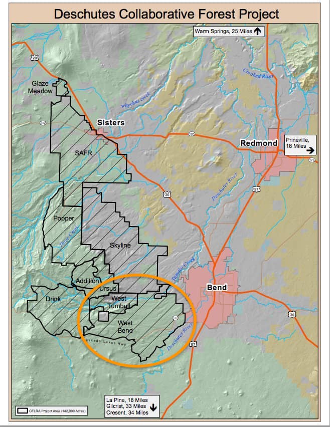
26,000 acres of our forest directly west of Bend, extending up to the boundary with the Bend Municipal Watershed Roadless Area. This includes the Phil’s Trail system, parts of the Deschutes River Trail system, the Virginia Meissner ski area, and more.
Key Benefits
- Making our forest more resilient and resistant to:
- climate change (increased temperatures and drought),
- wildfire, and
- insect infestation and disease.
- Restoring functional wildlife habitat.
- Protecting the municipal watershed that supplies clean drinking water (Tumalo and Bridge Creeks).
- Preserving long-term quality and access of high-use, year-round recreation areas and trails popular for gravel and mountain biking, river rafting, trail running, and other outdoor activities.
Why
Prior to settlers arriving in central Oregon:
- The forests experienced large & small low-severity wildfires about every 15 years.
- These fires typically traveled along the ground, burning grasses while moving around the trees without climbing up into the crowns.
- The trees were healthy and would organically drop their lower branches, a way to fight off fire from moving up into their crown and killing the whole tree.
- Fire puts important nutrients back into the soil, stops a good percentage of seeds from sprouting into trees, and keeps bushes from growing out of control.
- Historical records show a range of 32 to 60 trees per acre, including small trees less than 10 cm in diameter.
- 9 to 23 large ponderosa pine trees per acre.
- (This includes trees up to 21” in diameter and 150 years old.)
- The forest organically grew into different areas we’ve named:
- Patchy – Trees spaced out across the forest.
- Gappy – open areas for smaller trees, shrubs and/or open meadows.
- Clumpy – dense pockets of trees to provide quality habitat for wildlife and birds.
- The forest floor had more grasses and bushes, and although there were some clumps of trees, there were more open areas you could see a good distance.
Early 1900s to Today
Our forests were significantly affected by logging, tree farms, and wildfire impression.
- For the last 100 years, most fires that start in the forest are put out immediately, stopping both large AND small low severity fires from cleaning up the forest floor.
- Without fire, most seeds that hit the ground are growing.
- It is common to see up to 120 trees per acre AND in areas that were clearcut in the 1920s and 1930s and have not seen fire since, up to 170 trees/acre today!
- Having 2-3 times more trees per acres has negative effects:
- Our annual rain and snow levels are not enough to water this quantity of trees, the trees are growing slower, dying faster and can’t fight off beetle infestation.
- They are fighting for sunlight and are keeping their lower branches to help with sun exposure. The next time you ride, pay attention to how many trees still have their lower branches (fire climbs up these limbs to burn the crown, not good).
- Wildlife are struggling looking for the grasses and plants they eat, as these have been crowded out by all the trees.
- With more trees, fire is moving from tree crown to tree crown vs. the forest floor.
- Crown fires are hotter, killing the trees and baking the ground, removing all nutrients in the soil, inhibiting regrowth from happening.
- Our overgrown forests make it hard for fire fighters to stop fires.
- Wildland fire fighters can manage fire that moves along the forest floor – but it is very difficult to stop fires that move from tree to tree.
Funding
The West Bend Project is one of 10 demonstration sites nationwide selected to receive Congressional funding through the 2010 federal Collaborative Forest Landscape Restoration Act.
More Information
- What is the West Bend Project? / by Deschutes Collaborative Forest Project
- The West Bend Project (Overview) / by Deschutes Collaborative Forest Project
