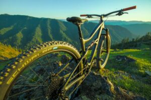
Waterdog


Highlights & Remarkable Spots
Landslide Climb / Gravel (mostly) / ~ Miles 0 to 12
Get ready for a demanding climb [3500 feet in 11 miles] with steep pitches [many over 10%, some over 15%] and a continually changing gradient. Partway along, you need to work yourself around a section of the road that has slid away.
From the parking area, make an immediate right, cross the bridge over Hill Creek, and begin to climb on a mossy one-lane paved road. At ~ mile 1.6, there is a gravel road that comes in from the right; that is your return road. Continue further along the paved road in the deep cover of the forest. At mile 3.5, the pavement gives way to an infrequently used single lane Forest Service dirt road.
The Willamette National Forest is famous for being at the center of the controversy between the logging industry and the endangered species status of the northern spotted owl. Environmentalists maintain that the forest was aggressively clear-cut for many years, threatening a federally listed endangered species. The timber industry contends that the forest can simultaneously provide lumber jobs and wildlife habitat. Since April 1994, the forest is governed by the Northwest Forest Plan, which restricts, but does not eliminate, logging in potential spotted owl habitat. [Wikipedia]
At mile 6, the road begins to twist and turn while climbing higher.(Micro-video) At ~ mile 8, when the views start to open up, the landslide is just ahead. The road closure is marked by a man-made embankment. Use caution as you work yourself around the right side of the slide in the bush, consider having one person at a time go. If you feel uncomfortable with the workaround/detour, call it a day and turn around.
After the slide, there is still some chunk to walk through and a second smaller slide to navigate your way around. The 0.2 miles of closed road will be mostly hike-a-bike.
Continue climbing! The route moves higher by contouring up an open ridgeline with expansive views to the west.(Micro-video) At ~ mile 11, you reach the summit. From here, it is a short drop down to Moss Junction. Get ready for some in your face views of Diamond Peak.
William Macy and John Diamond climbed Diamond Peak in July 1852. These two men were part of a preliminary survey party known as the “Road Viewers.” They climbed the peak in order to plan a road that later became known as the Free Emigrant Road. They named the peak for Diamond, who was a pioneer from Eugene. [Wikipedia]
The Waterdog Sector / Gravel / ~ Miles 12 to 24
In the elevation profile, the Waterdog sector is the upper base of the trapezoid. At first glance, the profile appears relatively flat, but it is really a series of small climbs [the most significant climb being 500 feet]. You gain and lose 1400 feet over this sector. It is not fast riding, but very scenic: flowers, mountains, meadows, and … Waterdog Lake. Most of the way is on a single lane gravel/dirt road with some coarse gravel and a bit of chunk. Take note; there are some rain ruts also.
From Moss Junction, so named for Moss Mountain, the route makes its way up Juniper Ridge.(Micro-video) To your left at the 8 to 9 o’clock position are unobstructed views of Diamond Peak. As you near the junction for Warner Mountain Lookout [~ mile 17], the beauty lies in the abundance of flowers. Indian Paintbrush, Bear Grass, and purple Fireweed. [Note, many of the flowers were still in bloom in mid-August when we did this ride.]
After a pitched and rocky downhill section (Micro-video) , Waterdog Lake pops up to your right. At ~ mile 19, make a right and begin the most impressive ridge climb of the day.(Micro-video) The mountain range far to your left is the Calapooya Mountains. The highest standing peak is Bohemia Mountain. Clustered around it are Fairview Peak, Elephant Mountain, and Jackass Butte.
In the 19th century, the Calapooya Mountains separated the tribal domains of the Kalapuya and Umpqua tribes. During the 1840s, the mountains proved a barrier to white settlers seeking to move into southern Oregon or to move southward to the California gold fields. [Wikipedia]
When you top out and bend around the shoulder of Groundhog Mountain [~ mile 21.4] it appears that the road ends. [Take note, it is easy to make a navigation error here.] There is a rugged track that leads up and to the right and there is a second rugged track that falls away to the left. Stay left and proceed downhill. It is steep, rocky, and loose. Be ready to put a foot down or walk a bit.
After 1 mile of this rugged “nonsense”, the track drops into a seldom used gravel road. You will feel relief from the technical intensity, but be ready to sing. It feels so much like bear country and there is little separation between you and the thick, impinging bush.(Micro-video)
At mile 24 a beautiful mountain meadow [Groundhog Meadow] appears and your descent road is just up ahead.
The area around Groundhog, Little Groundhog, and Juniper mountains is an amazing location for roadside botanizing, especially if you enjoy wetlands. There are also great rocky roadcuts and several shallow lakes. [Mountain Plants of the Western Cascades]
Groundhog Descent / Gravel (mostly) / ~ Miles 24 to Finish
Over the next 10 miles, you descend 3400 feet. Usually, we dread gravel descents this long, but not this one. The road surface is hard-packed and mostly free of washboard; it is evident that the road sees little traffic. The terrain on the descent is the reverse of that on the climb, open views at first, transitioning into a deep forest.
The descent follows the North Fork of Groundhog Creek. Along the way, there are several waterfalls to take in. They make for an excellent stopping point to shake out the neck and arms.
At ~ mile 31, Willow Creek road [gravel] comes in from the left. With this, you pick up a bit of washboard. But soon, you transition back onto pavement(Micro-video) and zip into the finish. Wow!
When We Like to Ride This
On a sunny day, from mid-summer to mid-fall. This is not a ride to do on a cloudy or foggy day; you give away all the big, spectacular views.
Terrain & Riding
Waterdog is one tough puppy. The bike math should be a good indication: 32 miles and 5,000 feet of climbing. But the route has a few extra challenges tossed in: a few landslide areas and a few pitchy roads (we got a quick glimpse of 22%.)
Now, if that doesn’t scare you off, the route is a wonderful mix of deep forest riding and ridge climbing with big open views. Add in meadows, Water Dog Lake, and a small waterfall, and you have a full-on fun adventure.
The Start
A paved pull out on the right hand side of Hills Creek road just before the intersection with NF 2308.
Lat / Long: 43.640566, -122.306894
Food & Water
- None.
Route Notes
The route is doable on 40 mm tires, but our choice would be 50+ mm.
Love Where You Ride! Learn More
 If you’re looking for a bike shop, consider Oregon Bike Shop and Willamette Mountain Mercantile.
Keep it Local! Learn More
Ridden and Reviewed by:


Have you ridden this route? Got a question? Join the discussion!