







Dirty Freehub
Favorites Sign In Search
  • Search
  • Donate
  • Gravel Rides
    • Explore by Region
    • Explore by Route Type
    • Explore by Collection
  • Programs
    • All Access®
    • Dirty Roads Crew
    • Gravel Champs
    • Passport Challenge
    • Route Stewardship
  • Stories
    • Bike Life
    • Culture & History
      • Central Oregon
      • NE Oregon
      • Bend Trails
      • Death Valley
    • People & Places
    • Lands
      • Arizona
      • Central Oregon
      • NE Oregon
    • Love Where You Ride
  • Events
    • Rides, Races & More
    • Submit Your Event
  • Help
    • Route Types
    • The Route Development Process
    • How We Rate Routes
    • Using the Searchable Map
    • Loading a GPX File
    • GravelPlex Maps
    • Glossary
    • FAQs
  • About
    • The Team
    • Our Missions
    • Impact Reports
    • Jobs + Volunteer
    • Press
    • Sponsors
    • Contact Us
  • Store
    • Gravel Guides
    • Merch
  • Donate
  • Cart
  • Sign In
  • Favorites

Triple Creek

Development Route / Joseph, Oregon / Published: Oct 2021 / Directions
Save to Favorites Remove from Favorites
*
Route:
Loop | 26 mi
*
Gain:
2,900 ft
*
Surface:
60% gravel, 40% paved
*
Technical Difficulty:
Moderate
*
Navigation:
Straightforward
*
Locale:
Remote
*
Tire Suggestion:
45 mm
*
Options:
---

The Wallowas are located in the northeast corner of Oregon and are home to Hell’s Canyon, Wallowa lake, and the Eagle Cap wilderness. We think the area is really under appreciated for the great gravel riding that it has.

The valley terrain is rolling hills with farmlands and the Wallowa mountains in the backdrop. The national forest terrain is more steep and rugged and remote.

Caution, this is a Development Route. It has not been fully vetted or ridden by the Dirty Freehub Team. Go prepared and expect a bit more adventure. Any feedback you have would be much appreciated. You can leave it below in the comments block.

Read More
Map
Brown = gravel / dirt road
Blue = single track
Red = paved road
Purple = paved bike path
GPX Download
(Version 0.1)

Caution! We do not provide turn-by-turn directions in our GPX files. Those are auto-generated by your bike computer and are usually less than 70% accurate. Learn more.

For help loading a GPX file onto your bike computer, go here.

Download

⚠️ GPX download won’t work in this browser

You’re viewing this in Facebook’s built-in browser, which blocks GPX file downloads. To download the file, use either of these options:

  • Tap the ••• (or ≡) menu in the top corner of the screen and select Open in External Browser.
  • Open the route guide directly in Chrome or Safari.

Once the route guide is open in your browser, tap the GPX Download button again.

Got it
Ride with GPS
(Open Route)

This is a new feature, and it will become a paid feature in the future as we pursue membership.

Open Ride With GPS
Learn More

Highlights & Remarkable Spots

~ Miles 0 to 4

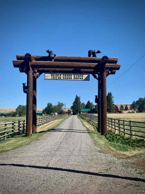
Some beautiful farm country at the start. To the left is the extensive Triple Creek Ranch. [References: Capital Press, Lynn Davison Suckow]

~ Miles 4 to 14

– The FS road varies in quality from fast and loamy to slow cobble rock.
– Views from the ridge on FS roads of The Seven Devils Mountains and a bit of the Wallowas.

~ Miles 14 to 24

Fun, pedal down descent on paved with little traffic.

~ Miles 24 to 25.5

A short paved climb near the end.

Ride Details

When We Like to Ride This

Late spring and fall are stupendous times to explore Wallowa County on variable surfaces. And summer is not bad also.

Terrain & Riding

The Dirty Freehub has team has driven the entire route. Also, we have had one rider complete the route. It looks to be 5 Star.

The Start

Lat / Long: 45.33716, -117.12485

Parking at a makeshift dirt lot. Nothing special.

Food & Water

  • None.
Notes & Options

Route Notes

  1. Recommend a red blinky light for the paved sectors (Miles 24 to the end will be the busiest). We really like the the units that come with rear looking radar detector. It is really cool to know of cars approaching from behind you without turning around.

Comments

Have you ridden this route? Got a question? Join the discussion!

Help Make this Guide Better!

At Dirty Freehub, we believe the best routes are organic and driven by the riding community. This route and guide are a work in progress, and we need your help to make it great!

Provide us with route feedback, both good and bad.

  • Let us know about points of interest and viewpoints,
  • Submit pictures and videos,
  • Suggest a best time to ride,
  • Let us know about a better or alternative option,
  • And tell us about your favorite place to go after the ride for a burger and beer.

Submit your feedback via the comments block (tab just above the map).

  • Route Views: 322
  • Route Downloads: 19

Sign Up for the Dirty Freehub Newsletter

info@DirtyFreehub.org
Terms of Service Privacy EEO Policy Our Values
Dirty Freehub is 501(c)3 non-profit organization.
©2026 Dirty Freehub :: Website Design
Cleantalk Pixel

WHY WE’RE DIFFERENT!

Eight scouting rides. Two community rides. More than a dozen mapped variations.

We just published the McCool route—but getting it ready took time. We rode it again and again, tested multiple options, and refined every mile before publishing it.

That’s the Dirty Freehub difference: routes that are vetted, curated, and maintained. If you value that kind of fieldwork, please support Dirty Freehub with a donation.

Donate Today