The Bombsite
The Bombsite Trail at ~ mile 27 has 15+ trees down over the first 0.3 miles, thereafter the trail is clear. We expect the trees to be cleared no sooner than the Fall of 2025.


Caution! We do not provide turn-by-turn directions in our GPX files. Those are auto-generated by your bike computer and are usually less than 70% accurate. Learn more.
For help loading a GPX file onto your bike computer, go here.
DownloadHighlights & Remarkable Spots
Port of Brookings Harbor / @ Start
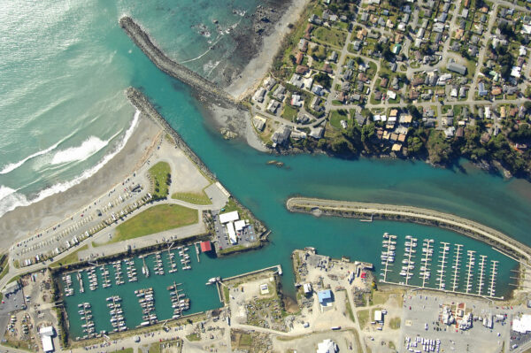
The Port of Brookings Harbor, constructed as a deep-water port by the Brookings Lumber and Box Company in 1912 to facilitate logging, is situated at the Chetco River’s mouth. Renowned as the busiest recreational maritime port on the Oregon coast, generating over 100 daily boat departures year-round and over 95,000 visitors. The port’s strategic location with a south-facing bar and the protection offered by Chetco Point makes the Chetco bar more navigable than other Oregon bars, contributing to its reputation for having the safest bar on the west coast. This combination of features renders the area as premier destination for chinook salmon fishing, attracting anglers globally.
Chetco River / ~ Miles 0 to 6
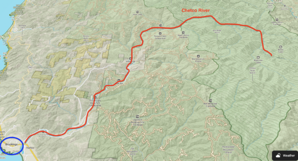
Over its 55.5-mile length, the Chetco drops from 3,700 feet to sea-level as it empties into the Pacific Ocean between the towns of Brookings and Harbor, about five miles north of the California border. In the upper section, the river floor is fairly narrow and boulder-strewn with numerous falls and rapids. As the river leaves the wilderness, its character gradually changes. The terrain becomes less dissected, the river gradient gradually becomes less steep, the river bottom widens, and the surrounding hills become more densely forested. The upper 45 miles of the river have been designated Wild and Scenic since 1988.
Chetco Bar Fire (Heavy Burn) / ~ Miles 11 to 16
July 12th of 2017 marks the beginning of the Chetco Bar Fire(by lightning strike), a blaze that remained quiet for almost a month before exploding into the nation’s most dangerous wildfire. As of July 28, fire officials believed that Chetco Bar fire would ultimately burn itself out. However, on August 15th, things went bad. The local winds, known as the “Chetco Effect,” showed up for the first time. The winds of 45 mph created a blast-furnace. On August 17th the fire jumped to the Chetco River’s south bank and reached 8,500 acres. Over the next few days, the fire would rip across 18 miles in 80 hours.
The Chetco Bar, a top 10 fire in Oregon history, would torch 190,000 acres, burn six houses, force 5,000 people to evacuate their homes.
Mt Emily / ~ Mile 10.5
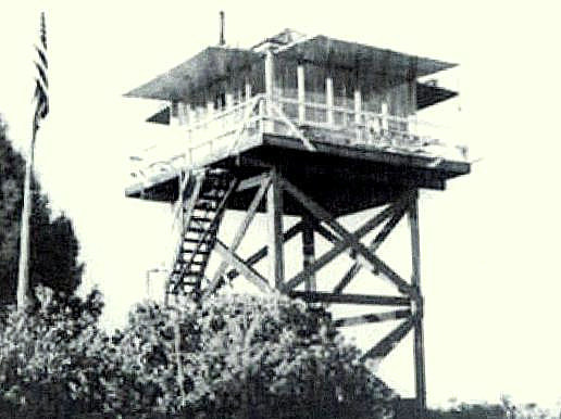
Up until the early 1970s there was a fire lookout atop Mt Emily. It is from there that the Japanese float plane was spotted. “One plane, type unknown, flying low, seen east, 2 miles, circling…” Howard Gardner, Aircraft Warning Service observer radioed those words to the Forest Service’s Gold Beach ranger station at 6:25 a.m. on September 9th, 1942.
Preston Peak & Bear Mountain / ~ Mile 13
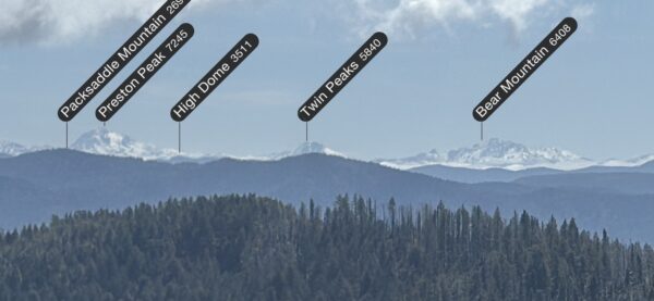
Preston Peak is a massive peak buried deep in the mountains of the rugged and remote northwest corner of California. It is the highpoint and reigning monarch of the Siskiyou Wilderness, and bar none the most rugged and spectacular peak in the entire Siskiyou Range. Its summit commands attention from far away, and is easily recognizable from many other peaks in the Klamath Mountains and Southern Cascades. The peak is rugged on all sides, rising 4000 feet in less than 2 miles from Clear Creek Canyon on its west side, and nearly 6000 feet on its east from Indian Creek Canyon. Its north face is most dramatic, an imposing 2000 foot wall of dark vertical granite. Nearly a dozen lakes and tarns are tucked into the peaks numerous cirques, the largest of which is Raspberry Lake, the deepest lake in the Siskiyou Wilderness.
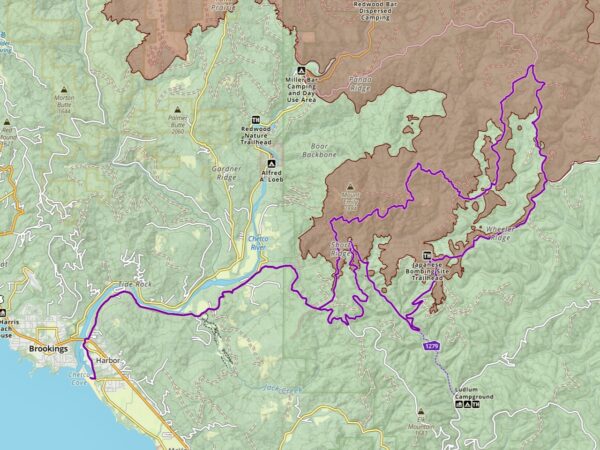
Wheeler Creek Research Area / ~ Mile 26.5
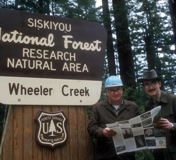
Wheeler Creek is one of the only protected redwood groves in Oregon. More than 45 percent of the trees in the 600-acre preserve are old-growth redwoods. The Research Area was established in 1972 to study undisturbed redwoods at the northern limits of their range.
About 25 percent of the redwood grove was severely burned in the Chetco Bar Fire. Many of the largest redwoods in the grove were already scarred from previous fires. Further, old-growth redwoods have exceptionally thick bark, which makes them highly fire resistant.
The Bombsite / ~ Mile 27
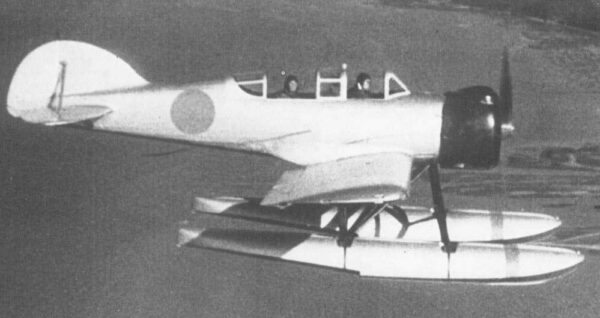
The Wheeler Ridge Japanese Aerial Bombing Site is the location of the first bombardment by enemy aircraft in the United States. It is one of only two such aerial incidents ever to occur on mainland American soil–both of which occurred during World War II. On September 9, 1942, two incendiary bombs were dropped from a Japanese floatplane that had been catapulted from a submarine with the intent of starting a wildfire. The bombing was an act to take revenge for the American bombing of Tokyo the previous April. Fortunately, due to damp weather, the fire did little damage and was easily extinguished. This well constructed 1.5 mile round trip hike, with excellent informational kiosks, is a must do!
Chetco Indian History Kiosk / ~ Mile 46.5
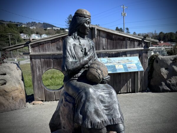
Near the end of the ride, there is small sign pointing towards the harbor and a display of Chetco Indian history. We recommend that you go and spend a few minutes. “In 1856, the U.S. Army forcibly removed the Chetco people to the Siletz Reservation. The Chetco had to travel two hundred miles north over rough terrain and swim the rivers with their children and elderly in tow. Some were abused by soldiers, and many died on the long, grueling march. Families were not allowed to stop to bury their loved ones and were forced to keep moving. The journey brought heartbreak and trauma to those who survived. [On-site kiosk]
Credits & Acknowledgements
This ride guide is funded in part by the Oregon Coast Visitors Association.
When We Like to Ride This
This route will go most of the year. We recommend looking for a sunny day with light winds.
Terrain & Riding
Chetco River Sector / Mile 0 to 6.5
This is a rolling, rual, paved sector along the Chetco river. As you lead out of the harbor, there is some traffic, but at slower speeds. There is also a bike lane. As you approach the intersection underpass there is a small A kicker hill at 13%. Don’t mistakenly get caught in the wrong gear. Thereafter the traffic is less, but we still recommend riding single-file with a red blinky light. There are several corners with limited visibility.
Mt Emily Sector / Miles 6.5 to 20.5
This sector begins with a challenging two-stepped ascent, climbing over 2,100 feet in seven miles. The first step, we affectionately label as a “Christmas tree climb” due to the color-coded elevation profile that displays green, yellow, red, and orange segments. This portion of the climb takes place on a single-lane road with a hard-packed gravel surface and features varying gradients between 6% and 12%. During spring, you will encounter numerous small creeks flowing across the road. The surrounding landscape is rich with red alders, firs, and pine trees, interspersed with ferns, lush grasses, and wild shrubbery.
At mile 9.5, the scenery shifts as you approach a contouring ridge and pass through the area affected by the Chetco Bar fire. From here, expansive views of the Pacific Ocean emerge, along with closer views of Mt. Emily. By mile 10.5, you can spot Chetco Peak (4,671 feet) to your right, often snow-capped in early spring.
The second step begins at mile 10.9. The climb cuts diagonally across the south shoulder of Mt. Emily through a heavily burned area with Manzanita and wild rhododendrons. The views are distant and big; to the Pacific and deep into the Siskiyou Mountain range. You summit at mile 14. From here until the end of the sector it a rolling ridge with ups and downs, about 650 feet up and 650 feet down.
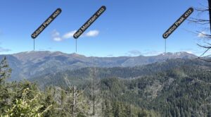
Vulcan Peak, Red Mtn, Chetko Peak Sector / Miles 20.5 to 23.5
 In this area, the forest composition notably changes, primarily featuring Grand Fir trees (also known as a Silver or White Fir) and Tanoaks. Unlike its name suggests, the Tanoak is not a true oak but is closely related to both oak and chestnut trees, but within the beech family.
Also along the sector at ~ mile 22.5, there is a view to the east of Vulcan Peak, Chetko Peak, and Red Mountain. And in front of Red Mtn you can see a tiny road that we plan to investigate further.
Wheeler Ridge Sector / Miles 20.5 to 40.5
This sector is classic Coast Mountain Range. Dense, moss covered trees, thick canopy, step hillsides, flowing creeks. It is also the most rugged and remote sector of the day. Also, our GPS units had difficulty locking onto track, thus they beeped at us incessantly telling us we were off-track when in fact we were not.
Since 2019 this road has been the primary way to access the historic bombsite, as the road has been unpassable from the west due to a major landslide. The landslide is expected to be repaired in the summer of 2024. See this link for a current update.
Miles 24 to 29 are along Wheeler Ridge, a rolling traverse. At ~ mile 27 you come to the Japanese Bombsite trail. Do it! There are a number of historical kiosks along the way detailing the history of this World War II event. The trail is about 1.5 miles round trip and doable in mountain bike shoes.
After the Bombsite, the route drops off Wheeler Ridge, losing 1400 feet of elevation in 3 miles for an average gradient of 8%. This is the most primitive road of the day. Rutted and washed out in spots, all rideable though.
At ~ mile 31.5 pick up Wheeler Creek. This is really fun riding. Scenic, rolling with an upward trend. The landslide is at the end of this sector, at about ~ mile 33.5. If the slide has been repaired, please drop us a note so that we can update the Ride Guide.
From here, it is gentle climb, followed by a fast 2.5 mile descent at an average gradient of 7% to the paved South Chetco River road.
Chetco River Sector / Miles 39 to Finish
This sector feels a bit more downhill than when leading out, but it is really not much different. You climb 450 feet and descend 550 feet. But … it is paved! And … when you get back to the harbor (~ mile 46.5), make the short detour to the Chetco Indian kiosk. Yes, this is worth your time!
The Start
Brookings Harbor / Beachfront park. Flush toilets.
Food & Water
- None
Route Notes
We recommend a red blinky light with a looking radar detector for this route. Something like a Garmin Varia.
Love Where You Ride! Learn More
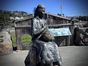 On the way back in, at the harbor, we have marked a small excursion to a history display about the Chetco people. We encourage you to go.
“The Chetco have lived on these lands for thousands of years. As early as the 1500s, Spanish explorers visiting the Pacific Northwest had contact with with Oregon’s coastal tribes. In the 1800s European settlers had increasing contact, bringing trade, disease, and new settlements of people.
In 1854, A.F. Miller led an attack and burned both indian villages at the mouth of the Chetco River to expand his ferry business. The people were shot as they came out of their houses and two were burned alive. In all twenty three men and several women were massacred.
In 1856, the U.S. Army forcibly removed the Chetco people to the Siletz Reservation. The Chetco had to travel two hundred miles north over rough terrain and swim the rivers with their children and elderly in tow. Some were abused by soldiers, and many died on the long, grueling march. Families were not allowed to stop to bury their loved ones and were forced to keep moving. The journey brought heartbreak and trauma to those who survived.” [On-site kiosk]
Videos
The Ride! Bombsite
A quick 2+ minute video of what to expect on your ride and (short) hike to the historic bombsite.
Samurai in the Oregon Sky (Trailer)
In 1942, Japanese pilot Nobuo Fujita bombed the U.S. mainland during WWII. He later peacefully reconciled with American civilians from the area. Watch this powerful film in its entirety.
Keep it Local! Learn More
Related Guidebook
Ridden and Reviewed by:


Have you ridden this route? Got a question? Join the discussion!