Skinner Toll Road


Highlights & Remarkable Spots
Jordan Valley / Start & End
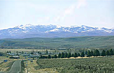
Jordan Valley was founded along the Skinner Toll Road. Among its earliest settlers was John Baxter, who established an inn, store, and post office in his cabin in 1867. The town served as a rest stop for miners journeying to nearby boomtowns like Silver City and DeLamar in present-day Idaho. Officially incorporated in 1911, Jordan Valley thrived while neighboring boomtowns dwindled after the mines faltered in 1875, thanks to its transition to cattle ranching. As of 2020, Jordan Valley has 179 residents.
Pelota Courts / ~ Mile 1
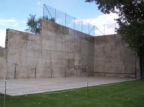
Originating from the Pyrenees Mountains in northern Spain and southwest France, Basque immigration to the U.S. peaked from the late 1880s to the mid-1920s. They brought with them their traditional games, customs, and celebrations, including the popular handball game, pelota. In Jordan Valley, Basque immigrants constructed this pelota fronton, or handball court, in the spring of 1915, using local stone. Restored in 1997 and commemorated with a Basque Fall Festival, this court stands as Oregon’s sole remaining Basque handball court today.
St. Bernard's Catholic Church / ~ Mile 1
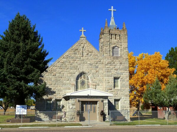
During its mining days in the late 1800’s, Jordan Valley did not have a church and only hosted visiting missionary priests from Boise and Baker. In 1914, Irish and Basque settlers began building St. Bernard’s Catholic Church from local stone. Oscillating between having an appointed priest and being a missionary church, St. Bernard’s has gone through a number of renovations, the most recent of which occurred in 2016.
Skinner Toll Road / ~ Miles 2 to 56
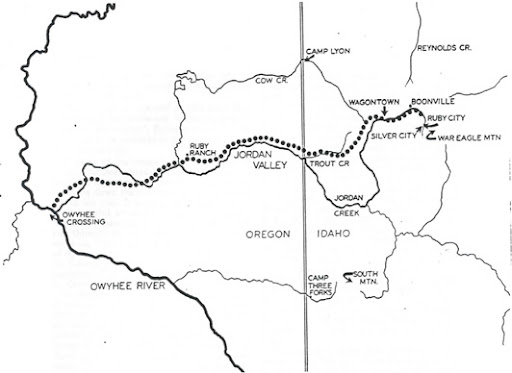
In 1865, Silas Skinner began constructing a toll road by hand, to aid in the transport of supplies for miners and the shipment of precious metals to the West Coast. The Skinner Toll Road, opened on May 19, 1866, linked to a route to Chico, California, and eventually to San Francisco, enabling freight to traverse between Silver City and Chico within a week. As traffic gradually shifted, more freight from Silver City traveled the Skinner Toll Road, leading to Chico via the Sacramento River, rather than the Columbia River route.
Jordan Creek / ~ Mile 15 to 41
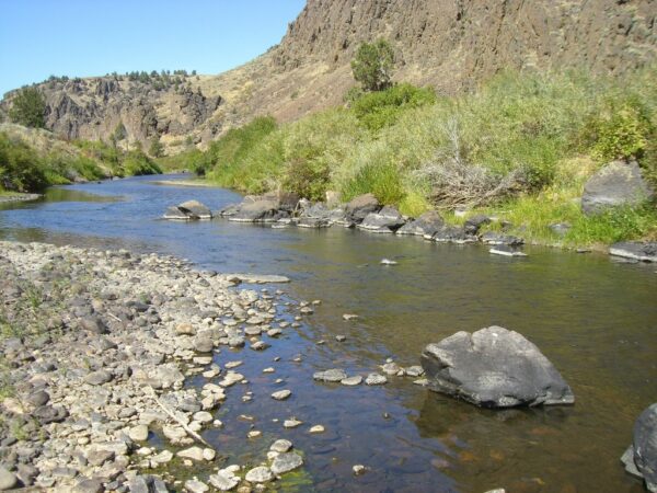
Jordan Creek is a 99 mile tributary to the Owyhee River. It was in this creek that the first gold placers were discovered in 1863, leading to the rush of growth in the area during the heyday of gold and silver mining. Today, Jordan Creek is used for irrigation for local ranches.
Aspen Tree Grove / ~ Mile 21
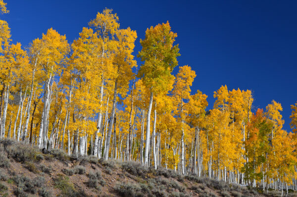
Aspens are the most widespread tree in North America. A grove of aspen is recognized to be one organism, meaning each tree is a genetic replica of all the trees in the group. In fact, one aspen grove in Utah is thought to be 80,000 years old, and is considered the heaviest living organism on earth. If you’re lucky to be on this route in the fall, keep your eyes peeled for the vibrant yellows and oranges that aspens are known for.
Ghost Town of Dewey / ~ Mile 22
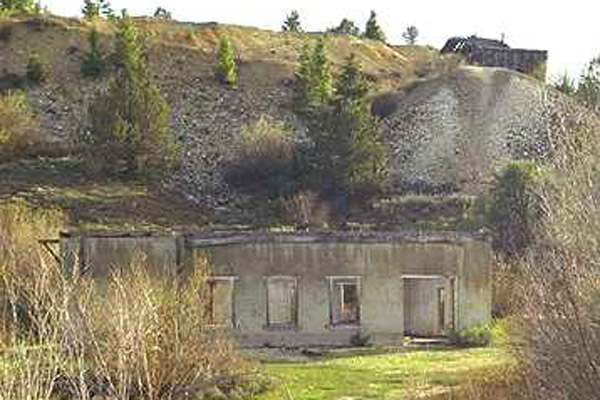
Only the cement power plant ruins and remnants of the mine stand as reminders of Dewey. Initially named Booneville, the town was purchased and rebuilt by Colonel W.H. Dewey in 1896. Renamed in his honor, Dewey flourished briefly with the construction of a grand three-story hotel, a post office, and a twenty-stamp mill. There was even talk of becoming the terminus for the Boise, Nampa, and Owyhee Railroad. However, the town declined as mining activity died, and the hotel succumbed to fire, ultimately leading to a ghost town.
Silver City & Cemetery / ~ Mile 25
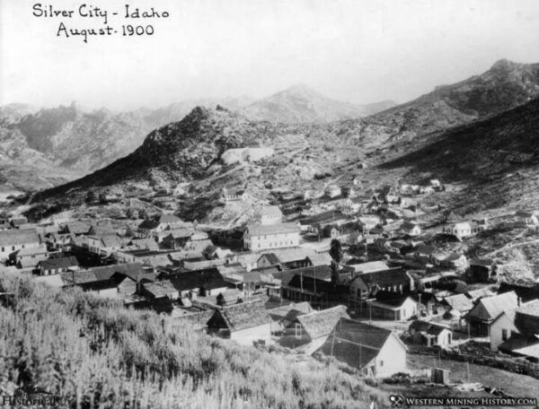
Today, Silver City is kept alive by tourism. Accommodations include a historic hotel, recently outfitted with indoor plumbing. Silver City has two prominent cemeteries—the Masons/I.O.O.F Cemetery and the Silver City Citizens Cemetery. A third cemetery, up Slaughterhouse Gulch hill, bears a simple sign reading “Cemetery,” serving as the final resting place for the town’s Chinese population. Chinese miners made up 21% of the population. Most of the Chinese graves in Silver City were relocated, leaving this Cemetery as a poignant reminder of the town’s overlooked Chinese residents amidst the romanticized tales of its mining heyday.
De Lamar Mine / ~ Mile 33
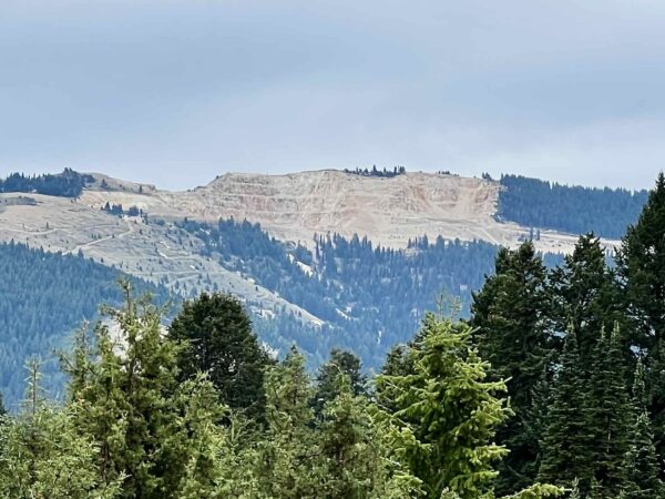
The DeLamar Mine, described as “the first modern open pit silver mine”, operated from 1977 to 1998. It has been reported that 625,500 ounces of gold and 45 million ounces of silver were produced over the life of the mine. In 2017, Integra Resources acquired the project and gold and silver mining is, once again, in active production in this area.
Split Rock Viewpoint / ~ Mile 47
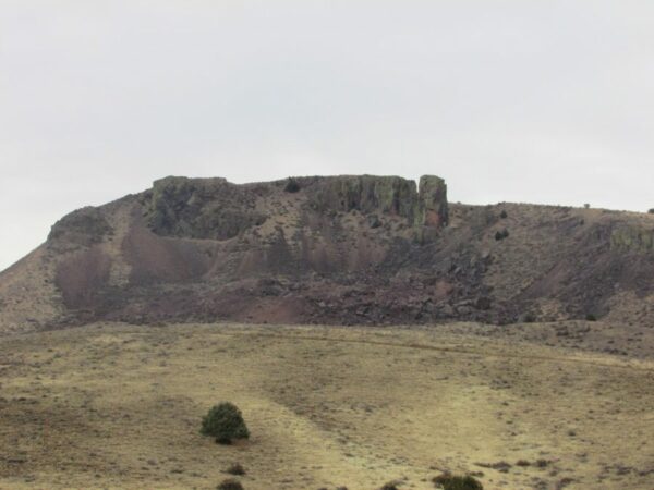
Located on a volcanic plateau, Jordan Valley was shaped by volcanic activity dating back approximately 150,000 years. Here, on the eastern edge of that plateau you will find, Split Rock. It has only 165 feet of prominence but impressive east and west faces that highlight the rock tower that is separated from the rest of the monolith.
When We Like to Ride This
This ride goes up to 6900 feet. Thus, expect a riding season from about May to October. If there is snow in the hills, the ride is a “no-go”. A really beautiful time to do this ride is when the trees are turning color in October.
The Silver City portion of this route, can be especially busy with cars (200+ per day) and tourists on summer weekends between Memorial Day and Labor Day. Weekdays are much less busy.
Terrain & Riding
Agricultural Lands Sector / Start to Mile 5
Initially leaving Jordan Valley you traverse through farming and ranch lands on the paved portion of the Skinner Toll Road which transitions to wide double-lane gravel road at mile 3. The road has been improved to provide access to the De Lamar mine. In front of you is a striking basalt ridge.
Long Ridge Sector / Miles 5 to 14
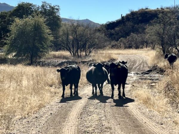
At mile 5, you leave Jordan Valley and climb up to Long Ridge via a gap in the rock. The traverse of Long Ridge is about 5.5 miles with a slight climbing gradient. The ridge is open and exposed with sage, scattered junipers, cows (open grazing) and vista views.
Jordan Creek Sector / Miles 14 to 22.5
At mile 14 you drop down to Slaughterhouse Gulch and enter a small canyon that parallels Jordan Creek. It is dotted with old mining structures in different states of disrepair. Some standing structures, some falling down, some with just a footing. Here is also where the double-wide gravel road narrows and becomes mostly single land. The terrain is grasses, junipers tucked into scattered rock outcroppings, and a mix of aspens and oaks along the creek.
At mile 18 you can take a small spur to the left that leads to an old cemetery. Lat/Long: 43.023760, -116.826724
Silver City Sector / Mile 22.5 to 27
At ~ mile 22.5, just after crossing through creek and 5900 feet, the terrain quickly changes to pines and aspens. The rock changes to smooth boulders from rocky cliffs and the soil changes to a white sand. On this sector you loop into Silver City and then exit and climb, 1 mile at 9%, to New York Summit.
Razr Loop / Mile 27 to 36
At mile 27, you go left on a small dirt road through a cattle fence. Get ready for the a big change in topography and terrain; much different than anything earlier in the day. Punchy, rugged, washed out. Metamorphic rock, pine trees, and occasional junipers. This portion of road / trail is used by OHVs, what we like to call Razr’s.
Usually can find a rideable line. But some sections will only be ridden by those with big power and exceptional bike handling skills. Others, may need to walk sections, no longer than 100 yards. Expect 15% pitches. 50 mm+ tires are a must. It is almost all rideable. However, it is Moab-esque; difficult and demanding.
Climb to 6800 feet. Here it is more forested trees with a lot of cool rock outcroppings. We really liked the beauty of this sector. At Mile 31 it gets much easier.
The loop comes back into stick just before Aspens grove that you passed on the way out.
The Return Along the Stick of the Lollipop / Mile 36 to Finish
Follow Jordan Creek back to Slaughterhouse Gulch. This is fun riding, slightly downhill. Quite scenic.
At Slaughterhouse Gulch, you encounter an ominous looking little climb, but in reality it is easier than it looks. 1.7 miles with an average gradient of 5%. Once you have gained Long Ridge it is undulating with downward trend. Split rock will come into view, and thereafter a quick descent to the valley floor and and easy spin back into Jordan Valley.
The Start
Jordan Valley City park. Flush toilets.
Lat / Long: 42.979466, -117.052892
Food & Water
- ~ mile 25.5 / Silver City
Route Notes
Open grazing and cows. Check out our resource page to learn how to pass by cows safely and without raising anxiety in the animals. Whooping and hollering is not the right thing to do.
We recommend a red blinky light with rear looking radar detector like a (i.e. Garmin Varia). The gravel roads along this route have some traffic, and it can be difficult to hear traffic approaching from behind. A Varia type of device really helps.
Route Options
- For a shorter and technically easier option check out the Silver City ride guide.
- For a shorter option including the Razr loop, start at the alternate start at Slaughterhouse Gulch at ~ mile 16 for a ride of 26 miles and 2500 feet of gain.
Love Where You Ride! Learn More
 Silver City is one of the few old mining towns that did not burn down or become commercialized into a modern city. Visiting Silver City is like going back into history. The Idaho Hotel is as it was 100 years ago with a few modern amenities. At Pat’s What Not Shop, books, souvenirs, local mineral samples are available. The Silver City Fire and Rescue Store provides art, antiques, gifts & backroom bargains. These are the only three public buildings within the city limits. All other buildings are private and part-time homes to many people. Please be respectful on your visit. Wave, stay on city streets (do not ask to tour someone’s private home!), and be respectful in the pictures you take.
Videos
The History of Silver City
Many miners struck it rich in Silver City, but it was also the site where a veritable war developed underground that took a militia to stop it. Learn more about this story and the history of Silver City in this 11 minute video.
Be Informed!
Keep it Local! Learn More
Ridden and Reviewed by:


Have you ridden this route? Got a question? Join the discussion!