









Dirty Freehub
Favorites Sign In Search
  • Search
  • Donate
  • Gravel Rides
    • Explore by Region
    • Explore by Route Type
    • Explore by Collection
  • Programs
    • All Access®
    • Dirty Roads Crew
    • Gravel Champs
    • Passport Challenge
    • Route Stewardship
  • Stories
    • Bike Life
    • Culture & History
      • Central Oregon
      • NE Oregon
      • Bend Trails
      • Death Valley
    • People & Places
    • Lands
      • Arizona
      • Central Oregon
      • NE Oregon
    • Love Where You Ride
  • Events
    • Rides, Races & More
    • Submit Your Event
  • Help
    • Route Types
    • The Route Development Process
    • How We Rate Routes
    • Using the Searchable Map
    • Loading a GPX File
    • GravelPlex Maps
    • Glossary
    • FAQs
  • About
    • The Team
    • Our Missions
    • Impact Reports
    • Jobs + Volunteer
    • Press
    • Sponsors
    • Contact Us
  • Store
    • Gravel Guides
    • Merch
  • Donate
  • Cart
  • Sign In
  • Favorites

Little Brother

5 Star (Quick Build) Route / ~ Bend, Oregon / Published: Jun 2025 / Updated: Oct 2026 / Directions
Save to Favorites Remove from Favorites
Leading out!
The parking area
*
Route:
Loop | 37 mi
*
Gain:
1,700 ft
*
Surface:
100% gravel
*
Technical Difficulty:
Moderate
*
Max Gradient:
+5% / -5%
*
Sustained Gradient:
5% over 0.8 miles
*
Climb Ratio:
0.5
*
Effort:
2 (out of 5)
*
Navigation:
Straightforward
*
Locale:
Remote
*
Tire Suggestion:
45 mm+
*
Options:
Longer

If you are looking for a gravel route that feels less like a simple bike ride and more like a pedal-powered time machine, this loop through the southern margins of Crook County is your holy grail. This ride is an immersive plunge into the silent, sun-bleached, and intensely beautiful soul of Central Oregon’s high desert. As the gravel crunches beneath your tires, you will trace the footsteps of 19th-century cattle barons, skim the borders of ancient super volcanoes, and ride alongside the vibrant wildlife and working livestock that call this rugged country home.

While the nearby gravel havens of Bend and Sisters offer riding on geologically “new” pumice dust and Cascadian pine forests, this southern Crook County loop plunges you into a starkly beautiful, multi-million-year-old landscape — one that rewards riders with speed, silence, and a story in every mile.

This loop is not just scenic — it is geologically and historically dense. You ride across ancient hardpack clay, volcanic silt, and gritty ranch roads that follow the margins of the Crooked River Caldera, the John Day Formation, and the broader high desert of Central Oregon. Compared with the younger pumice soils around Bend and Sisters, this route offers deeply weathered terrain, smoother hardpack when dry, and a far older volcanic story under your tires.

This route is part of the Brother series – Little Brother, Half Brother, Big Brother. All starting near the ghost town of Brothers, Oregon and looping into the Maury Mountains or in the case of this route, skirting the southern boundary of the Maury Mountains (part of the Ochoco National Forest).

Read More
Map
Brown = gravel / dirt road
Blue = single track
Red = paved road
Purple = paved bike path
GPX Download
(Version 0.1)

Caution! We do not provide turn-by-turn directions in our GPX files. Those are auto-generated by your bike computer and are usually less than 70% accurate. Learn more.

For help loading a GPX file onto your bike computer, go here.

Download

⚠️ GPX download won’t work in this browser

You’re viewing this in Facebook’s built-in browser, which blocks GPX file downloads. To download the file, use either of these options:

  • Tap the ••• (or ≡) menu in the top corner of the screen and select Open in External Browser.
  • Open the route guide directly in Chrome or Safari.

Once the route guide is open in your browser, tap the GPX Download button again.

Got it
Ride with GPS
(Open Route)

This is a new feature, and it will become a paid feature in the future as we pursue membership.

Open Ride With GPS
Learn More
Ride Details

When We Like to Ride This

Jan
Feb
Mar
Apr
May
Jun
Jul
Aug
Sep
Oct
Nov
Dec
Not Rideable
Possibly Rideable
Rideable

We like this route in late spring and early summer when the creeks are running full, the sage is intense green, the grasses are tall and the flowers are in bloom. The route rides well for the most part from mid-April to early November. If you go early or late in the riding window, check snow levels as the route peaks out at 5000 feet.

During the months of July and August, go early. The heat can be intense and there is little to no tree cover, you are exposed.

Avoid during windy days.

Terrain & Riding

You will experience rolling farmlands, desert sage, colorful rhyolite and basalt cliffs, and flowing creeks.

The Start

At the intersection of Camp Creek Road and Merrill Road.
Lat / Long: 43.87256, -120.48796

At the intersection of Camp Creek Road, where the pavement ends, and Merrill Road, approximately 12 miles northeast of Brothers, Oregon. Park on the side of the road, there is no formal parking area.

Notes & Options

Route Notes

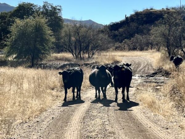
  1. You may come across cattle grazing freely along the route. Before you ride into the herd like a gravel cowboy, take a moment to check out our resource page on Cows—it’s full of tips for passing safely.

    A few things to consider before approaching: Is there a bull in the bunch? Any protective mommas with young calves? These factors matter.

    The worst approach? Charging through the herd while whooping and hollering like it’s a rodeo. That only stresses the animals and can lead to unpredictable (and unsafe) behavior. A calm, measured approach is best. Sometimes you may even need to stop, remove your helmet and sunglasses so you look more human, and walk your bike past the herd.

    Think about it: If a pack of six strange creatures with giant heads, bug eyes, and four spinning limbs (two wheels + two legs) came speeding toward you… wouldn’t you be tempted to run—or fight?

Route Options

Longer Options
Half Brother
55 miles / 3100 feet of gain / 100% unpaved / Loop

  • Route Map: View in Ride With GPS
  • GPX File: Download

Big Brother
71 miles / 4500 feet of gain / 90% unpaved / Loop

  • Route Map: View in Ride With GPS
  • GPX File: Download
Comments

Have you ridden this route? Got a question? Join the discussion!

This is a Quick Build Route Guide

A Quick Build route is a fully vetted Dirty Freehub route that meets the same high standards as our Premiere 5-Star routes. The difference isn’t the ride—it’s the route guide.

A Quick Build guide includes everything you need to confidently ride the route, but it doesn’t yet include all of the rich content found in a Premiere 5-Star guide, such as detailed ride stories, points of interest, local history, photography, community highlights, and expanded planning information.

Why do we publish Quick Build routes?

We’ve identified hundreds of exceptional 5-Star routes that deserve to be shared. Creating a full Premiere guide takes significant time and resources, and we don’t want great rides waiting behind a lengthy production process. By publishing Quick Build guides, we can make more outstanding routes available sooner while continuing to work toward their full Premiere editions.

Our goal is to upgrade every Quick Build guide into a Premiere 5-Star guide.

Why? Because a Premiere guide does more than help you navigate. It connects you to the places you ride—the landscapes, history, culture, businesses, and people that make each destination unique. Riders who engage with these stories are more likely to stay longer, explore more, and support local restaurants, lodging, bike shops, and other small businesses—creating a greater economic impact in rural communities.

Your donation makes that happen. Every contribution helps fund the writers, photographers, researchers, editors, and route specialists who transform Quick Build guides into immersive Premiere 5-Star guides.

If you believe in connecting people to great rides and strengthening rural communities, please donate today. Together, we can publish more world-class route guides and bring more exceptional gravel routes to riders everywhere.

Be Informed!

Cows in the road

Cows!

This route crosses through open grazing lands where you may encounter cows and cattle. Learn how to handle this situation the right way. Whooping and hollering are not it!!

Read More »

Explore Similar Routes:

Farm Lands Geology Historic Cemeteries pioneers
  • Route Views: 2,249
  • Route Downloads: 170

Sign Up for the Dirty Freehub Newsletter

info@DirtyFreehub.org
Terms of Service Privacy EEO Policy Our Values
Dirty Freehub is 501(c)3 non-profit organization.
©2026 Dirty Freehub :: Website Design
Cleantalk Pixel

WHY WE’RE DIFFERENT!

Eight scouting rides. Two community rides. More than a dozen mapped variations.

We just published the McCool route—but getting it ready took time. We rode it again and again, tested multiple options, and refined every mile before publishing it.

That’s the Dirty Freehub difference: routes that are vetted, curated, and maintained. If you value that kind of fieldwork, please support Dirty Freehub with a donation.

Donate Today