Elk River Ramble


Caution! We do not provide turn-by-turn directions in our GPX files. Those are auto-generated by your bike computer and are usually less than 70% accurate. Learn more.
For help loading a GPX file onto your bike computer, go here.
DownloadHighlights & Remarkable Spots
Cape Blanco Lighthouse / ~ Port Orford
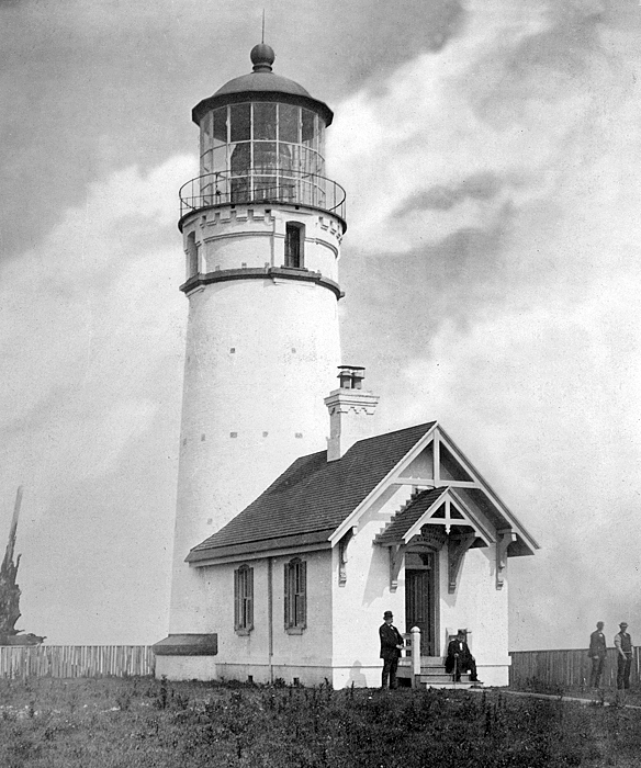
The lighthouse was first lit on December 20, 1870, and used a first-order Fresnel lens, which was a state-of-the-art technology at the time. It is at the westernmost point of Oregon and is the oldest remaining lighthouse on the coast. Made of brick with walls about 5 feet thick at the base, it stands 59 feet tall, but due to its position on a cliff, the light is approximately 245 feet above sea level.
Port Orford Lifeboat Station / Port Orford
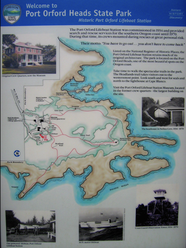
The Port Orford Lifeboat Station was constructed in 1934 by the Coast Guard to provide lifesaving services to the southern portion of the Oregon Coast until 1970.
“From a viewpoint on the Cove Trail, watch for remnants of the stairway to Nellies Cove where the old boathouse was located. It sheltered two 36-foot motor lifeboats, but unfortunately burned down in the late 1970s. You can still see its pilings and breakwater structures as well as portions of a rail-mounted carriage used to launch the boats into the cove.”
From the museum we hiked the Tower Trail to a viewpoint and then circled back in on the Cove trail. For the map, click on the image to the left.
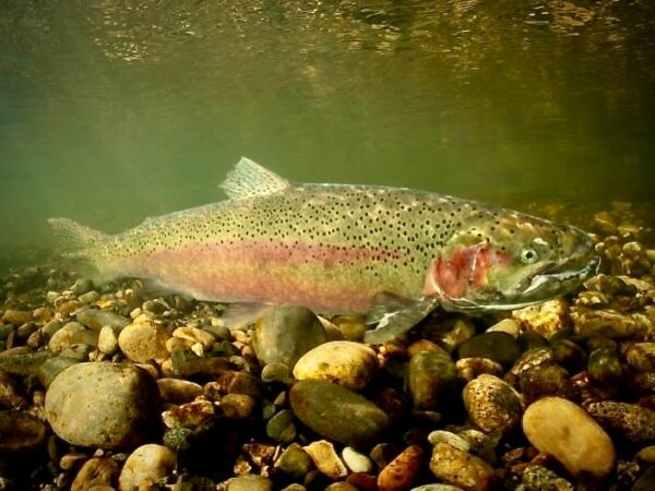
Elk River Fish Hatchery / @Start
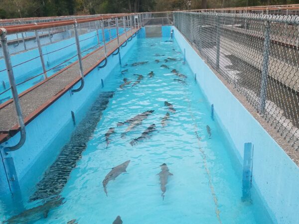
The hatchery was completed in 1971. It has 10 ponds and an intake. The hatchery raises steelhead and Chinook salmon.
The two best times of the year to visit the hatchery are during December and January and then again during July, August, and September.
Elk River Watershed / ~ Miles 0 to 3 and Miles 24 to 39
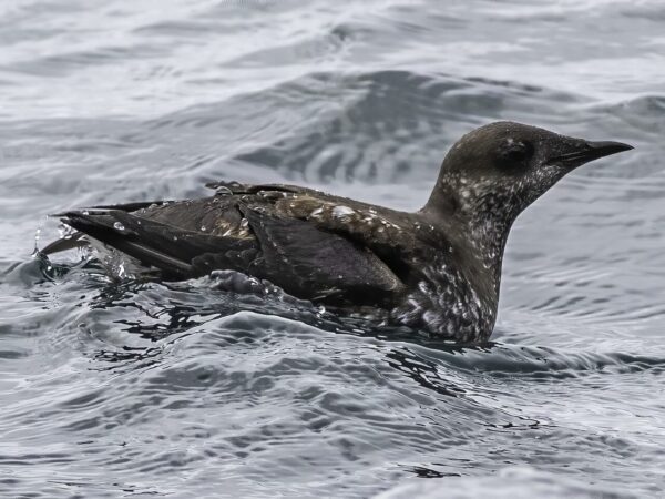
The Elk River Watershed is home to one of the largest Marbled Murrelet populations in the United States, a seabird that’s also a forest bird. The Marbled Murrelet fishes along the foggy Pacific Coast, then flies inland to nest in mossy old-growth trees. Mottled in milk-chocolate brown during the summer, adults change into stark black and white for winter. These stocky little birds dive for zooplankton and fish using their wings to “fly” underwater. Because they rely on old-growth trees for nesting, logging is a threat to their numbers. Though still numerous in Alaska, they are listed as threatened in Washington, Oregon, and California.
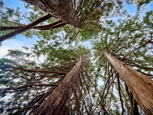
Old Growth Doug-Fir / Miles 7.5 to 8

60″+ in diameter.
Copper Salmon Wilderness / ~ Miles 20 to 28
The Copper Salmon Wilderness (to your right as riding) contains one of the nation’s largest remaining stands of low-elevation old-growth forest, with Douglas-fir trees as large as 10 feet in diameter and up to 300 feet in height. It also includes the North and South Forks of Elk River and the upper Middle Fork of Sixes River; one of the healthiest salmon, steelhead, and cutthroat trout runs in the continental United States.
Grassy Knob Wilderness / ~ Miles 28 to 39
Designated a wilderness in 1984. Here you will find rare stands of old growth Port Orford cedar with some trunks exceeding six feet in diameter. It has a very limited natural range, primarily found in a small region of southwest Oregon and northwest California.
Port Orford cedar has been prized in shipbuilding since the 1850s, with its use peaking in the early to mid-20th century. Shipbuilders valued for its strength to weight ratio, durability, water resistance and workability.
Credits & Acknowledgements
This ride guide was funded in part by the Oregon Coast Visitors Association.
When We Like to Ride This
This is a great ride spring through fall. In spring the creeks are running full and fast. But, look for a sunny day. In the summer it’s a great “beat the heat” route with all the shade cover. Get an early start, and when coming back in along the Elk River, find a swimming hole to jump in. In the fall, the colors explode.
Terrain & Riding
River Sector (Leading Out) / ~ Miles 0 to 3
- Tall trees. Mossy rocks. Darting sunshine. Rushing streams.
- Classic coast range forest. Doug Fir, Red Alders, Big leaf maples. Dense and mossy. Heavy tree canopy.
Purple Panther Sector / ~ Miles 3 to 18.5
- Traverse by Purple mountain and Panther Mountain.
- Purple Mountain climb.
- – Dense forest.
- – Climb starts out hard, 8% with pitches at 15%, then backs off. Christmas tree climb.
- – On this climb, numerous steep pitches of over 10%. Short, but many.
- – Mile 7.5 peak-a-boo views looking over Port Orford and Pacific Ocean.
- – Mile 7.5 to 8.0 whole set of old growth Doug-Firs, 200 to 500 years old.
- At top of climb begin a traverse. Much younger forest with many long vista views.
- Panther mountain climb
- The second climb.
- Not as long, not as steep. Feels more like a traversing ridge. Vista views.
- Bonus trees: Dogwoods.
South Fork Descent / ~ Miles 18.5 to 28
- The descent is more moderate than the climbs. The “true” descent is about 1900 feet of elevation loss, then a gradual 1 to 2% descending gradient.
- Expect some washout and ruts.
- Just before mile 20, there is a beautiful stand of tanoaks to the right.
- From mile 20 on, the route is bounded to the north (your right) by the Copper Salmon Wilderness and Grassy Knob Wilderness.
- At Laird campground the texture changes to lush green forest with red alders.
- At ~ mile 23 the North Fork of Elk River and South Fork merge. A number of small flowing creeks cross under the road.
- At ~ mile 28, when you intersect the paved road, go right several hundred yards the Butler Bar bridge over Elk river. This is a really beautiful viewing point.
River Sector (On Return) / ~ Miles 28 to 39
- We like to call this sector Waterfall Alley. As you ride back in there are a series of small waterfalls to your left. Super cool! Springtime is best.
- Rolling paved road.
- This is one of the most natural and wild rivers we have seen. Big rocks, canyons, tree fall, rapids, and an aqua, aqua blue color.
The Start
Elk River State Fish Hatchery. Dirt parking lot. Pit toilet.
Food & Water
- None
Route Notes
The elevation gain of 3600 feet listed in our guide is accurate. Some apps incorrectly show the gain exceeding 4200 feet, this information is not correct.
This is the Coast Mountain range. You should always expect logging traffic. Tell tale signs: CB channels posted, mile markers posted/painted on trees, truck tracks in the dirt, and a relatively good gravel road. Our recommendations are to ride single file, use a rear red blinky light and a front white blinky light and do not override your sight lines or be listening to music. One of the best ways to know if a truck is nearby is by sound. If meet a truck, on-coming or over-taking, stop and put a foot down. Do not try to ride through. And … a wave is always a nice gesture.
We recommend a red blinky light with a rear looking radar detector for the paved sectors of this route. Something like a Garmin Varia or Trek Car Back.
A really great way to do this ride is to arrive the evening before and camp at Cape Blanco state park. Take an evening walk or easy ride and visit the historic Cape Blanco lighthouse and the historic Hughes House.
Videos
The Ride! Elk River Ramble
A quick 2+ minute video of what to expect on your ride and a quick tour of the historic Coast Guard Lifeboat Station in Port Orford.
Port Orford Lifeboat Station
An ~ 7-minute video narration of the Coast Guard Lifeboat Station Museum in Port Orford, Oregon.
The Waters of Port Orford
An in-depth look at the waters of Port Orford and their importance to the community. A great 9-minute watch. Highly recommended!
Podcasts
Marbled Murrelet
Learn more about the Marbled Murrelet with Dr. Jim Rivers, a wildlife ecologist and researcher at Oregon State University specializing in avian ecology, forest management, and conservation biology. In this discussion, he explores the unique behaviors of this elusive seabird and its rare [...]
Keep it Local! Learn More
Related Guidebook
Ridden and Reviewed by:


Have you ridden this route? Got a question? Join the discussion!