Dropbar


Caution! We do not provide turn-by-turn directions in our GPX files. Those are auto-generated by your bike computer and are usually less than 70% accurate. Learn more.
For help loading a GPX file onto your bike computer, go here.
DownloadHighlights & Remarkable Spots
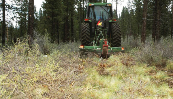
West Bend Forest Project / Miles 2 to 9
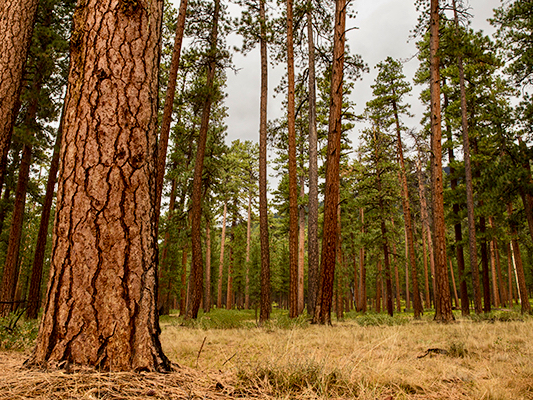
Along this section of trail you are riding through the West Bend Project, a 15-year forest management effort that includes tree thinning, brush mowing, and controlled burns. The project received Congressional funding through the federal Collaborative Forest Landscape Restoration Act. There are only 20 such demonstration sites nationwide. The goals of the Project are: to restore forest ecosystems, reduce the potential of high-severity wildfires, and provide economic and social benefits to local communities. See the resource page in the right sidebar (desktop) or towards the bottom of page (mobile).
Skyliners Lodge / ~ Mile 11
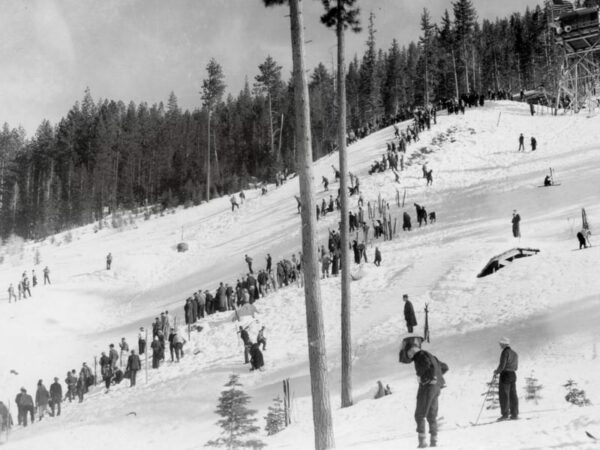
The lodge was completed by WPA workers in 1936 for the Skyliners Club, a group founded in 1927 to promote winter recreation in the central Oregon Cascades as well as provide search and rescue services. The lodge offered all the amenities needed for large competitions and the area featured two large ski jumps, an expansive cross-country trail system, and downhill skiing. [Bend Magazine]
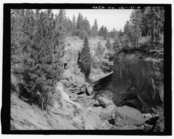
Bridge Creek Fire / ~ Miles 11 to 16
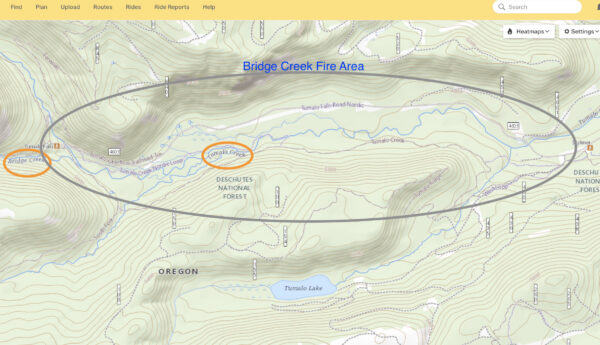
In 1979 an abondoned campfire exploded into a raging wildfire, burning 4,300 acres of old growth spruce and pine forest. In 1980 foresters removed all burned trees, both standing and fallen.Over the next 25 years, erosion carried 15,000 yards of cubic sediment downs Tumalo Creek severely impacting fish, wildlife, wetlands and water quality. In 2004 restoration efforts were begun. [See video in sidebar]
Tumalo Falls / ~ Mile 14
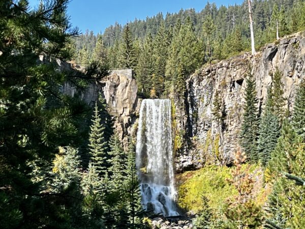
“The exact origin of the word Tumalo is not known. One possibility is that the original name may have been Tumallowa, which is said to mean icy water – an adjective that fits considering Tumalo Creek is fed by glacial melt. For years Tumalo Falls’ height was stated as 97 feet tall. However, in July 2010 the falls was measured at 89 feet. Where the original number of 97 feet came from is unknown, but because it stood unquestioned for so long, it likely stemmed from the early 20th century when the falls were first discovered.” [Northwest Waterfall Survey]
Columbia Southern Canal / ~ Mile 19
The Columbia Southern Canal was built to feed water from Tumalo Creek to the infamous Tumalo Reservoir. The building of the reservoir was key in creating a farming oasis and the subsequent settlement of Central Oregon. However, the reservoir soon failed due to lava tube leakage.
Bridge Creek Water Supply System / ~ Miles 14 to 26
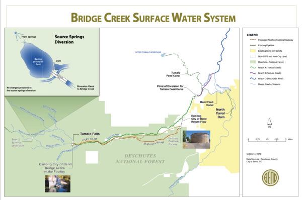
Bend has relied on groundwater and surface water to supply drinking water to local taps since 1926. These aging pipelines required replacement. The $70 million Bridge Creek Water Supply and Treatment Plant project (circa 2015) included a 10-mile-long, 30-inch pipeline installed underneath Skyliners Road. The intake at Bridge Creek, near Tumalo Falls, is the highest operating intake in the Northwest. The intake building addresses seismic risk and fire protection. Pumps send heated water to the intake screen to prevent frazil ice buildup—a design first in the state of Oregon. Intake controls allow the City to reduce diversion when water is not needed, helping to maintain healthy fish habitat. The new automated Outback Water filtration facility (near FS 4606 and Skyliners) guarantees 10 million gallons of water per day to City residents.
When We Like to Ride This
Recommended spring through late fall. This route is not subject to extreme moon dust like some other mountain bike trails in the dead of summer.
Terrain & Riding
A lot of fun to ride drop-bar single-track (ie. mountain bike trails rated easy to easy-intermediate). All of the trail can be ridden without putting a foot down. Gravel Girl walks two short sections of technical. The other surfaces are a 50 / 50 mix between primitive forest service dirt road and the wide double-lane gravel road. The gradients are rarely above 5%. This is an up-down route. You climb persistently to Tumalo Falls, and from there, you persistently descend back to town.
The terrain is mostly ponderosa pine forest with occasional vista views. At ~ mile 14.3 a “secret” connector brings you through a set of aspen trees that pop with color in the fall. This section can be wet in the spring and fall; but it is, oh so fun! You can re-route around this section by staying on the main gravel road leading to Tumalo Falls.
Food & Water
- None
Route Notes
Recommend a red blinky light with a rear-looking radar detector, like a Garmin Varia, for the paved sectors and the closer-to-town riding.
This is a really good route to work your technical skills on and a really good route to test your navigation prowess. The route is close to town, and there are many bail-out points back onto Skyliners road, which leads directly back to Bend.
The route has a significant amount of dropbar single-track. It is rated mountain bike easy+. Those with good technical riding skills will be able to ride it “clean”, others may have to put a foot down a couple of times.
Love Where You Ride! Learn More
![]() This route includes a significant amount of single-track trail. The Central Oregon Trails Organization (COTA) manages and maintains these trails for riding. Like Dirty Freehub, they are a non-profit. We encourage you to give back with time, money or talent to COTA or your local trails organization. It is easy to forget, that trails and routes require your on-going support.
This route includes a significant amount of single-track trail. The Central Oregon Trails Organization (COTA) manages and maintains these trails for riding. Like Dirty Freehub, they are a non-profit. We encourage you to give back with time, money or talent to COTA or your local trails organization. It is easy to forget, that trails and routes require your on-going support.
Videos
The Ride! Dropbar
A quick 2-minute video of what to expect on your ride!
The Story of Tumalo Creek
Learn about (3-minutes) the restoration of Tumalo Creek back to a healthy stream after the devastating Bridge Creek wildfire in 1979.
Podcasts
Single-Track Trail Etiquette (Who has the right of way?)
Ever wonder who has right of way on those single-track trails? Downhill rider? Uphill rider? The runner? Who? In this episode of The Connection, we speak with Emmy Andrews the Executive Director of the Central Oregon Trails [...]
Be Informed!
Keep it Local! Learn More
Ridden and Reviewed by:


 Behind every route is scouting, mapping, storytelling, and a whole lot of pedal power.
Have you ridden this route? Got a question? Join the discussion!