Bird Nerd


Caution! We do not provide turn-by-turn directions in our GPX files. Those are auto-generated by your bike computer and are usually less than 70% accurate. Learn more.
For help loading a GPX file onto your bike computer, go here.
DownloadHighlights & Remarkable Spots
Malheur Lake / @Start
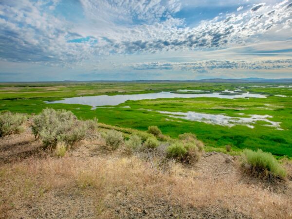
Looking out over the Refuge headquarters, you may see a vast lake or you may see no evidence of a lake at all. But Malheur is not an actual lake. It is one of the largest inland marshes in the United States varying dramatically in size from 500 to 110,000 acres, with up to a depth of 8 feet. The “lake’s” water level and size is determined by how much water it receives from the Blitzen and Silvies Rivers, the snowpack on Steens Mountain.
Meeks Wagon Train / Near the Start
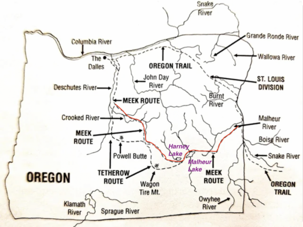
The Meeks Wagon Train of 1845, led by frontiersman Stephen Meek, was an ill-fated attempt to find a shortcut to the Willamette Valley in Oregon. Approximately 1,000 emigrants with 200 wagons departed from the main Oregon Trail near Vale, Oregon, and ventured into the uncharted high desert. As the wagon train entered the Harney Basin, finding water and feed for their livestock became critical. They camped near Harney and Malheur Lakes, but the alkaline water was unsuitable for humans or animals. The group eventually reached The Dalles, but not before enduring the harsh conditions of the high desert. Reports of deaths during the journey range from 23 to as many as 50. Click on map.
Steens Mountain / Recurring Views

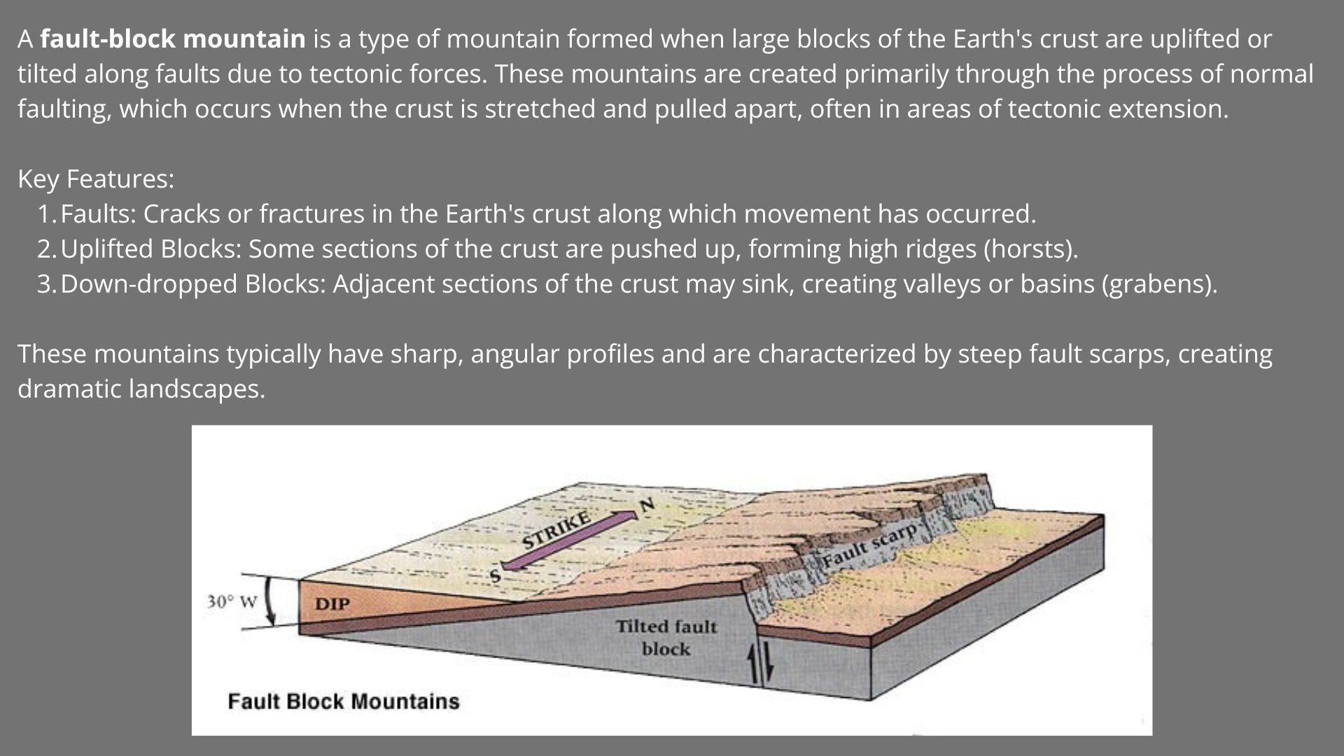
With a summit approaching 10,000 feet, it is a classic fault-block mountain, gently sloping on its west side, but dropping vertically a mile to the Alvord Desert on its east side. Snow melt from the broad western face is carried downhill by five major streams, which eventually merge to become the Blitzen River. Over the eons, the river has deposited many feet of sediment on the valley floor. These fertile soils, combined with the waters of the Blitzen River, provide an optimal foundation for the marshes and wet meadows of the Refuge.
Rattlesnake Butte / ~ MIle 10
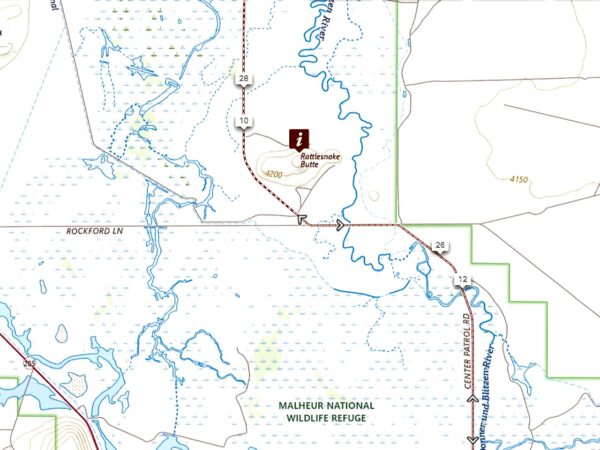
Rattlesnake Butte, which appears to your left, has been important to people since prehistoric times. Nearby, a rocky ledge extends across the Blitzen River providing the only natural crossing for miles. This point of access, along with the availability of water and a butte from which to survey the surrounding land, made this an important place for bands of Northern Paiute people who first occupied the Blitzen Valley as early as 9,600 years ago. Click on image to right.
Blitzen River Channelization / ~ Miles 14 to 16.5
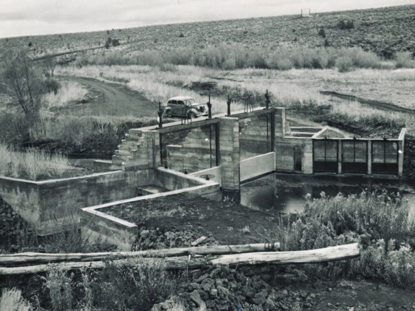
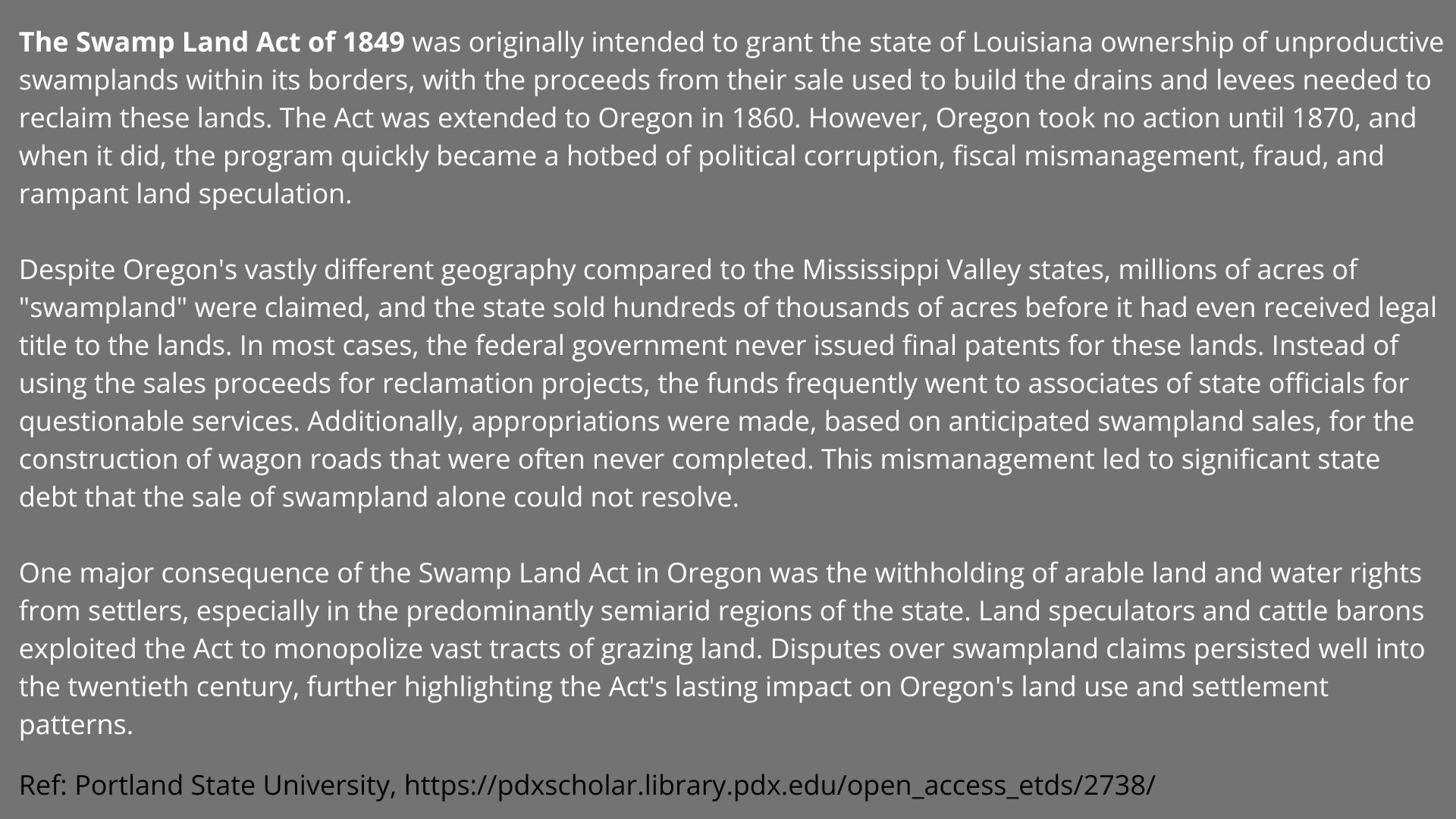
In this sector the river was straightened and channelized starting in 1872 with the arrival of John William “Pete” French, who established the P Ranch along the river’s lower course through what became known as the Blitzen Valley. French and his employees dug several ditches to drain the river’s wetlands—a hazard to rangeland cattle—and to increase grassland for grazing. This effort was tied to the Swamp Land Act of 1849, aimed to drain meadows for grazing and hay production. In Oregon the program was plagued by political corruption, fiscal mismanagement, fraud, and land speculation.
Buena Vista Overlook / ~ Mile 19
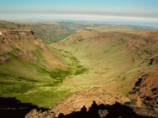
As you look southeast at Steens Mountain from here, you will see what looks like a rugged chasm on the north side. This is the famous Kiger Gorge, a classic U-shaped valley carved by ice age glaciers. Although the continental ice sheet did not reach this far south, Steens Mountain was high enough to develop its own glaciers, which left the mountain with five U-shaped gorges. Kiger and McCoy Creeks drain from the north side of the mountain, entering the Refuge through the Diamond Valley, the wide gap in the rimrock to your left. The image shows Kiger Gorge from north to south. From the overlook, you are looking into the gorge from the north (the top of the picture).
Sod House Ranch / ~ Mile 38
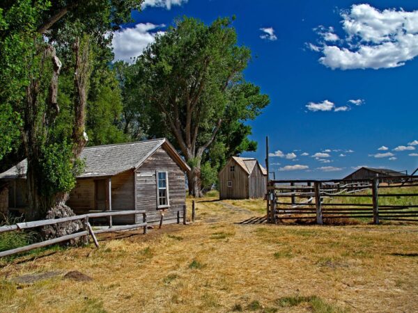
This ranch was the northern headquarters of the 140,000 acre cattle empire of Californian Hugh Glenn. When the Californian Legislature ended open range grazing in 1872, Glenn sent 23 year old Pete French to Eastern Oregon to establish a cattle ranch. French traveled from California with 1200 long horn cattle, six Mexican vaqueros (cowboys) and a Chinese cook to this remote corner of Oregon. Over the next 25 years French acquired property using a variety of methods in the Blitzen, Diamond, and Catlow Valleys to create one of the largest cattle ranches in the United States. The ranch is open to the public from August 15 through October 15. Explore this detailed guide to the ranch.
Credits & Acknowledgements
This ride guide is funded in part by a grant from Travel Oregon.

When We Like to Ride This
Spring to early summer (peak mid-May to mid-June) is especially spectacular at Malheur National Wildlife Refuge, with over 130 bird species nesting there and many others stopping to rest and refuel during their northern migration. We highly recommend checking out this Watchable Wildlife guide and this Spring Migratory Bird Arrival Dates guide by the US Fish & Wildlife Service for detailed information on when and where to spot specific birds.
Terrain & Riding
The route is primarily flat and 100% gravel roads. While it may seem like an easy ride on paper, there are a couple of factors to consider. Parts of the national refuge may have freshly laid gravel (especially in the spring after road maintenance), there may be sectors of washboard that slow you down and the area is subject to strong winds (go early!). However, I would not let any of these elements stop me from going to one of the best birding areas in all of Oregon.
We recommend that you download the auto route guide for more insights into your journey.
From the visitor center, head south into the refuge, affectionately called “Bird Nerd Alley.” Along the way, you’ll encounter expansive views, thousands of birds, rabbits, and antelope, as well as mostly smooth and easy riding. The route crosses the Blitzen River several times, offers up continuous views of Steens Mountain, and passes by vibrant wetlands and some active farmlands.
… scan the cottonwood trees for various songbirds, great horned owls, and porcupine. Other species in the area include the cinnamon teal, coyote, deer mice, gadwell, garter snake, great egret, great horned owl, long-eared owl, mallard, mule deer, Northern oriole, Northern shoveler, pied-billed grebe, porcupine, and trumpeter swan. [US Fish and Wildlife Service]
At approximately mile 21, turn right onto a gravel road that cuts through the Buena Vista ponds wetlands. Why you pass a set of buildings on your left, look for the road leading up to Buena Vista Overlook. This spot is worth the short climb, offering a sweeping bird’s-eye view of the refuge.
If you’re a bird enthusiast and visit during prime birding season, this route will undoubtedly provide an unforgettable adventure.
The Start
Malheur National Wildlife Visitor Center
Alternate Start
Lat/Long: 43.066441, -118.870059
Buena Vista overlook parking lot.
Food & Water
- None.
Route Notes
The road conditions can change significantly throughout the year depending on usage, maintenance, and time of year. When we rode this, there was little washboard but a heavy, thick, new gravel layer for several miles. However, we have had reports of heavy washboard. If this is of concern, we recommend contacting the the US Fish & Wildlife Service at Malheur (541) 493-2612 and inquiring about the road conditions and the last time the road was graded.
If you go during birding season, carry mosquito repellent with you … or move really, really fast!
At ~ mile 33.5, there is a left option to the historic Sod House Ranch. We only recommend this option when the ranch is open: from August 15 to October 1.
Explore the Malheur Wildlife Refuge website to access seven brochures featuring information on birdwatching, the auto tour route, wildlife, the historic Sod House, and more.
We would love to have pictures of the route, birds and animals from the cycling community. We think our picture deck is lacking! Thus, if you have some great pictures to share with us, send the to info@DirtyFreehub.org Please send in high resolution format, with route name, date, and your name.
Route Options
Shorter Options
- Blitzen River Bridge / Rattlesnake Butte from Malheur Visitor Center. 22 miles, and 250 feet.
- Blitzen River Bridge / Rattlesnake Butte from Buena Vista Overlook. 16 miles, and 250 feet. This option starts from the alternate parking area. Ride the route as mapped, using miles 19 to 27 followed by miles 11 to 19.
Love Where You Ride! Learn More
![]() The Friends of the Malheur National Wildlife Refuge are doing some awesome work on the Refuge. They’ve fixed up the Refuge Headquarters Historic Barn, built some cool bird-watching and nature trails, put up signs for the Blitzen Valley Refuge auto tour, and lots more. Plus, they run neat programs like the Artist in Residence-Youth Wildlife Art Program and do events like the National Wildlife Refuge Celebration week every October. If you’re into what they’re doing, think about throwing a few bucks their way. Every little bit helps, whether it’s $10, $25, or whatever you can spare.
The Friends of the Malheur National Wildlife Refuge are doing some awesome work on the Refuge. They’ve fixed up the Refuge Headquarters Historic Barn, built some cool bird-watching and nature trails, put up signs for the Blitzen Valley Refuge auto tour, and lots more. Plus, they run neat programs like the Artist in Residence-Youth Wildlife Art Program and do events like the National Wildlife Refuge Celebration week every October. If you’re into what they’re doing, think about throwing a few bucks their way. Every little bit helps, whether it’s $10, $25, or whatever you can spare.
Videos
Preserving the Harney Basin
This 5-minute video highlights the tremendous value of partnerships to enhance and preserve the Malheur National Wildlife Refuge and surrounding private lands in Harney Basin. The issues facing th Basin are larger than any one person, group or agency can address alone, but together, [...]
Podcasts
Deceptive Waters of Malheur Lake
Located in Harney Basin in eastern Oregon, Malheur Lake sits within the 187,000 acres of Malheur National Wildlife Refuge, an area that is an important wildlife habitat. Aquatic Biologist, [...]
Keep it Local! Learn More
Related Guidebooks
-

All Access Gravel Guide Eastern Oregon (Collector’s Edition!)
$12.50Now shipping! A 64-page pocket-sized gravel guide. Featuring gravel routes, art, culture and local history. A one of a kind…Add to cart -

All Access Gravel Guide Western Oregon (Collector’s Edition!)
$12.50Now shipping! A 64-page pocket-sized gravel guide. Featuring gravel routes, art, culture and local history. A one of a kind…Add to cart
Ridden and Reviewed by:


Have you ridden this route? Got a question? Join the discussion!