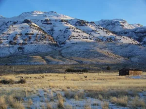
Barnhardy


Highlights & Remarkable Spots
Up the Barnhardy Stick / Primitive Dirt Road / ~ Miles 0 to 4
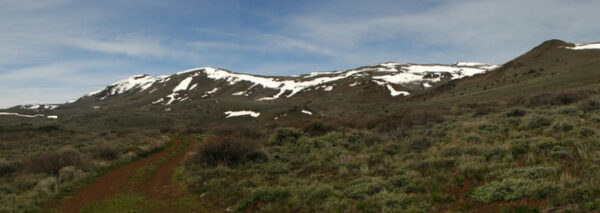
This is one of the most demanding and rugged starts that we have documented.
The first 3/4 of a mile, leading out of the parking lot, is relatively tame. Then … bam! The road kicks up and becomes rutted and gnarly.(Micro-video) It is all rideable, but with a strong effort. The pitches can be steep, nearing 15%.
But … don’t forget to look around. The beauty is amazing! A mix of willow and aspen trees. A small creek. Barren, grass-covered hills. And Warner Peak (to your right).
Mid-way through the first 4 miles, there is a slight downhill respite through Barnhardy Meadows. There may be a puddle or two. Then … bam! It kicks up again. Just after mile 4, you intersect Skyline road. Go left.
Skyline Drive / Primitive Dirt Road / ~ Miles 4 to 11
Skyline Road will continue to climb but at a much more moderate gradient. There will be a series of short bouldery rock gardens to navigate. All rideable, but with skill. Be sure to look back over your right shoulder; there are some amazing views to the south and west.
You will peak out at 7150 feet. In 0.5 miles, the road turns north, and the gravel becomes smooth and fine. Straight into the distance is Steens Mountain [elevation 9734 feet], and to the east is Beatys Butte [elevation 7896 feet]. To identify Steens Mountain, look for Kiger Notch (or Gunsight Notch as it is known to locals).
Steens Mountain is a large fault-block mountain stretching some 50 miles north to south, rising from the Alvord Desert (on the east) at an elevation of 4,200 feet to a summit elevation of 9,733 feet. It is sometimes confused with a mountain range but is a single mountain. [Wikipedia]
At mile 8.5, you are rewarded by a fast, swoopy downhill. But, be warned … when you see a cluster of Juniper trees dead ahead at the bottom of a grade … it is about to get steep, steep … at 15%. It is only for several hundred yards.
We stopped at the Juniper cluster. The trees are almost magical and make for some really cool and unique pictures. After this, drop a couple of hundred more feet and go right on Blue Sky road.
Blue Sky Road / Gravel / ~ Miles 11 to 20
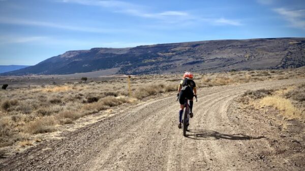
The next 8 miles roll up and down [gaining and losing 500 feet] on the most proper gravel road of the day. It is barren and harsh, a windswept high desert landscape dominated by sagebrush and a few Juniper trees.
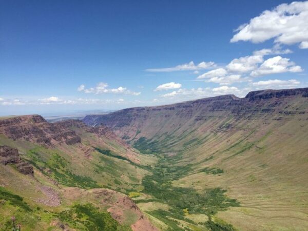
As you head further south, the grasslands of Spanish Valley and the Warner Mountains of northern California and Eagle peak come into focus. The Spanish Valley area is explored by the South Boundary route that we have documented.
The Warner Mountains are an 85-mile long mountain range running north-south through northeastern California and extending into southern Oregon. The range extends from the northeastern corner of Lassen County, California, through eastern Modoc County, California (east of Alturas), and northward into Lake County, Oregon (east of Lakeview). The highest peak in the range is Eagle Peak, with an elevation of 9,892 feet. [Wikipedia]
The flat topped ridge to the right of Spanish Valley is Hart Mountain.
Soon you will come to a gate with a sign marking a grave sight and a sign marking Barnhardy road. The spur left leads to a gravesite and the most likely spot to see elk within the refuge. It is a short detour. The road and all the spurs off it dead end, but the colors and texture are not to be missed.
This area is the site of historic Camp Warner, an old military outpost dating back to the mid-1800s. While no remnants of the outpost remain, there are the gravesites of two soldiers that are maintained and respected by visitors. [Wikipedia]
Barnhardy-Guano Creek Climb / Primitive Dirt Road / ~ Miles 20 to 22
Next up is the Barnhardy-Guano Creek climb [2.6 miles, 800 feet of gain]. It starts with a short 15% pitch on loose, rocky terrain. Luckily it ends quickly, and the climb becomes more moderate [4 to 6%]. The road is mostly a dirt double-track / jeep track. Guano Creek is to the right and lined with deciduous trees with leaves that glow with color in the soft fall light.(Micro-video) And bonus … there is a creek or two to cross; you can ride through most.
Down the Barnhardy Stick / Primitive Dirt Road / ~ Miles 22 to 26
You’re at the top when you see the sign for Skyline Road. Keep straight and repeat the stick of the lollipop. Some sections will be technical and demanding. But the views are outstanding. Take your time, and all will go well.(Micro-video)
Now, go jump in the hot springs! (This is just at the east side of the parking lot.)
Credits & Acknowledgements
By Kevin English and Linda English of Team Dirty Freehub.
When We Like to Ride This
Late September through mid-October, when the leaves are changing color.
If you pick another time to do the ride, the Barnhardy road segment (from the start at the hot springs to just past the campgrounds at Guano Creek) is only open to travel from August 1 to December 1.
Terrain & Riding
Before starting we recommend taking a look the official map of the area.
The Start
Hot Springs campground at Hart Mountain National Antelope Refuge. Note, the drive to the start, from Plush, involves 14 miles of gravel road (a true gravel road) that can be severely washboarded.
Lat / Long: 42.501856, -119.689726
Food & Water
- None.
Route Notes
For this route, you will want low gearing, something lower than 0.90 gear ratio, and wide rubber, something wider than 50 mm. Others may prefer a hardtail mountain bike versus a gravel bike.
The route rides well in both directions; the way we have mapped and documented the route is in the easier riding direction. The opposite riding direction (counterclockwise) is a bit more scenic. But … more of the climbing is backloaded, making for a longer, final descent (that is technical).
In our 2 days of riding in the refuge, we saw several herds of antelope, a couple of solo buck antelope, deer, and sage grouse.
If the fall, this is an active hunting area (bow and rifle). We recommend riding in a hi-viz kit. Check with the Hart Mountain headquarters for exact dates.
Route Options
For a shorter ride, remove the lollipop stick and start at Lookout Point (mile 11.4 on the original route). The route is then 18 miles with 1800 feet of gain. To access Lookout Point, use the Blue Sky road, a proper gravel road. At the viewpoint, there is a small turn around area where you can park. (Lat / Long: 42.481273, -119.632191)
For a longer ride, add in the South Boundary loop.
Love Where You Ride! Learn More
 Hart Mountain National Antelope Refuge was established on December 20th, 1936 by President Franklin D. Roosevelt to serve “…as a range and breeding ground for the antelope and other species of wildlife…” Today, management of the Refuge has broadened to include conservation of all wildlife species characteristic of this high desert habitat and restoration of native ecosystems for the public’s enjoyment, education, and appreciation. Even cooler, the oldest evidence of humans in North America may have been found near the Refuge.
Videos
The Ride! Barnhardy #4
A quick 2-minute video of what to expect on your ride!

Have you ridden this route? Got a question? Join the discussion!