Alder & Iron


Caution! We do not provide turn-by-turn directions in our GPX files. Those are auto-generated by your bike computer and are usually less than 70% accurate. Learn more.
For help loading a GPX file onto your bike computer, go here.
DownloadHighlights & Remarkable Spots
Fort Hoskins / @ Start
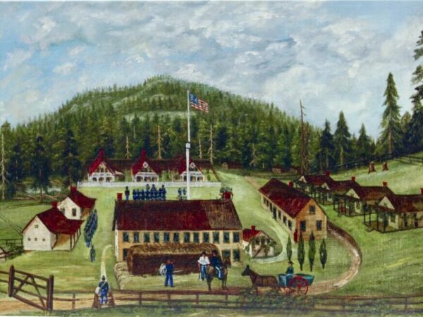
Established in 1856, the fort housed 200–300 troops tasked with two key missions: protecting the newly created Coast (Siletz) Indian Reservation to the west from settler encroachment and harassment, and confining and monitoring the tribes on the reservation. During the Civil War, the troops also worked to prevent the secessionist movement in the mid-Willamette Valley from escalating into armed conflict. The fort was closed in 1865.
From a soldiers diary: “”Wed. Mar. I, 1865. Rather cold all day. Snow covers the ground.
I am on guard. We have a large pot of coffee sitting by the fire, from which we draw now and then (near midnight). No drill in the snow. Had plenty to eat all day.” [Ref: on-site kiosk]
Hoskins (the town) / @ Start
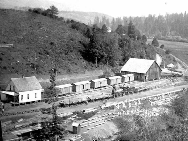
The town of Hoskins emerged in 1865 after buildings from Fort Hoskins were sold at auction following the fort’s closure. By 1891, the population had grown enough to establish a post office. The town thrived for a few decades as the headquarters of the Valley & Siletz Railroad, hosting diesel engines and passenger cars. However, as the timber industry declined, so did Hoskins. The post office closed permanently on December 31, 1958, and the railroad section through Hoskins was removed in 1979 after being sold to Boise Cascade. Today Hoskins is a ghost town.
Commander's Residence / Near Start
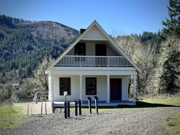
The Commander’s Residence is one of only two surviving military buildings from Oregon’s pre-Civil War era, making it one of the most historically significant houses in the state, according to Oregon State University archaeologist David Brauner. A classic example of its type, the house features a formal parlor and private quarters on the ground floor, with bedrooms upstairs and a rear section for the kitchen and service areas. It was first occupied by Capt. Christopher Colon Augur, who later had a distinguished military career, including serving as commandant of cadets at West Point and earning a promotion to general during the Civil War.
Hoskins School / Near Start
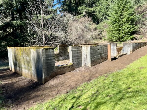
Constructed in 1915, this foundation once supported a schoolhouse abuzz with the spirited sounds of 20-25 children in grades 1 through 8. When the population of the area increased following construction of the Valley & Siletz Railroad through Hoskins, mill owner Samuel Frantz donated an acre of land for this school, which replaced the original schoolhouse built in 1875 across the river.
During rainy winters, it was often too muddy for children to make the trip to school, so the original academic year was only four months long, beginning in April. In the 1920s, the school adopted a standard nine-month academic year that began in September. [Ref: on-site kiosk]
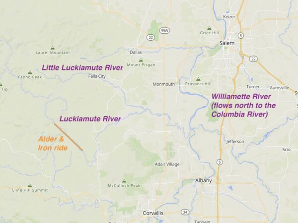
Luckiamute River / ~ Miles 5.5, 7.2, and 16.7
Interesting Facts:
– The river originates (about 2.7 miles north of the end of the ride) in the Coast Range and flows in a circuitous counterclockwise circle moving eastward before emptying into the Willamette River between Albany and Salem. Click on the map to left for an expanded view.
– The River has two main branches: the Little Luckiamute River (originating 9 miles west of Fall City) and the main Luckiamute River.
– The name “Luckiamute” is derived from the Native American Kalapuya tribe who lived in the region. The meaning of the name is unknown.
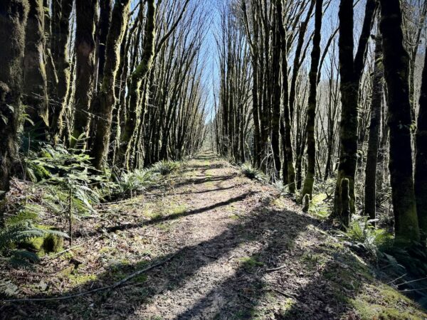
Red Alder Alley / ~ Miles 7.5 to 10
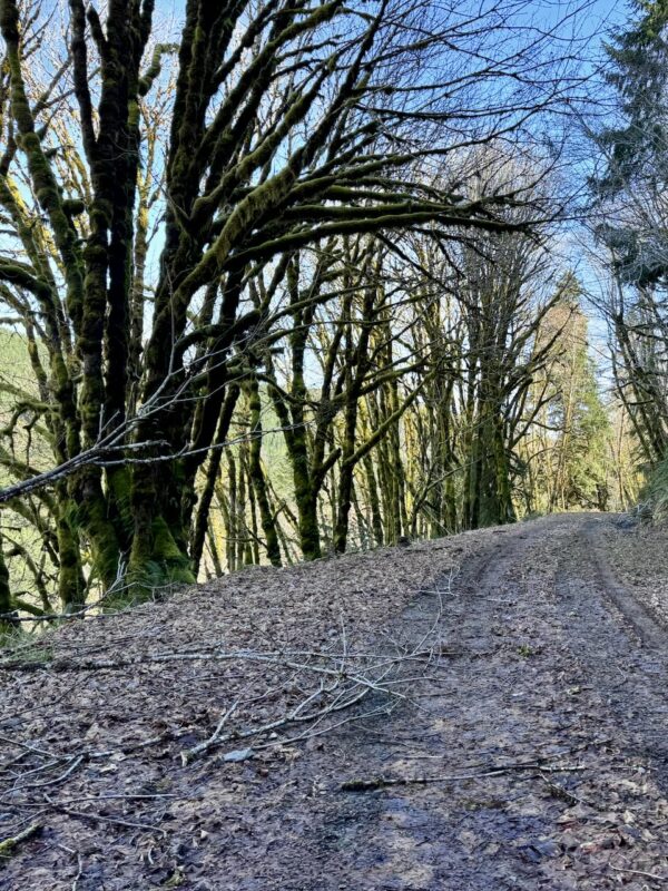
Red Alders are often some of the first trees to regenerate after clear-cut logging. Here’s why:
– Red Alder seeds are small, light, and easily carried by the wind, allowing them to spread quickly across disturbed areas like clear-cuts.
– These trees thrive in open, sunny conditions that clear-cuts provide. Their rapid growth enables them to outcompete slower-growing species in the early stages of forest regeneration.
Red Alders don’t typically dominate a forest for the long term (due to their shorter lifespan of 50–100 years), they play a vital role in restoring the ecosystem after clear-cut logging, paving the way for more complex, conifer-dominated forests like Douglas fir, Sitka spruce, and western hemlock to re-establish over time.
This area has most likely not been re-logged due to being sensitive wetland habitat.
Valley & Siletz Railroad / ~ Mile 10.5
Take a careful look to your right at mile 10.5 as riding and you’ll spot this old railroad grade—once part of the Valley & Siletz Railroad. Constructed between 1912 and 1917, this 40.6-mile railroad operated from 1912 to 1978. It served as a critical connection between Independence, a city along the Willamette River (to the east of here), and Valsetz, a logging community deep in the Oregon Coast Range. The line closely followed the Luckiamute River and the path of this ride. Hoskins was the operational hub of the railroad during its active years.
Fun fact: The name “Valsetz” is a portmanteau, a blend of two words, “Valley” and “Siletz.”
Frantz-Dunn House / Near Finish
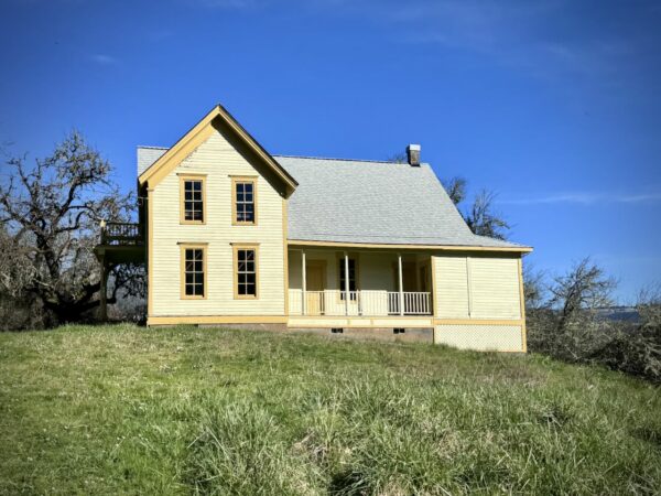
In November 1866, Samuel and Mary Frantz arrived in Hoskins, Oregon, with their seven children after traveling by wagon from Iowa. Using lumber from the local Hoskins mill, Samuel built this Gothic Revival-style home around 1869. The house features a T-shaped design, typical of Gothic Revival architecture from that period, but its asymmetrical front elevation makes it unique. Remarkably well-preserved with minimal alterations since its construction, this house stands as one of the finest examples of Gothic Revival architecture in Benton County. Despite its impressive style, the home originally lacked interior plumbing.
Credits & Acknowledgements
This route guide was funded in part by a grant from Travel Oregon.

When We Like to Ride This
This route is ridable nearly year-round, with a peak elevation of just 600 feet. If conditions are good in the Willamette Valley, they’re likely good here too.
We especially love riding it in the spring, when everything is lush and green and the river runs high. Fall is also a favorite, with vibrant foliage adding color to the landscape.
The only time to avoid this ride is right after heavy rains in the valley, especially during the winter. The route is likely to be muddy and difficult to ride.
Terrain & Riding
The terrain is a mix of Coast Range forest and farmlands. In the forested sections, you’ll ride beneath a canopy of Douglas-fir, western red cedar, and bigleaf maple, with stands of red alder thriving in the wetter lowlands. The understory is lush, especially in spring, with sword ferns, vine maple, salal, and Oregon grape. Moss-draped branches and lichen-covered trunks give the forest a quiet, ancient feel, while seasonal wildflowers like trillium and oxalis bloom along the roadside.
The surfaces are a mix of quiet paved roads, champagne gravel, and hard-packed gravel logging roads. For the most part, the route follows the path of the old railway, thus the gradients for the most part are less than 2%. There are two exceptions to this, leaving and entering Fort Hoskins State park and one small hill at ~ mile 11.
There are 3 excellent spots to view the Luckiamute River, at:
– mile 5.5 when cross over the river on a steel bridge
– mile 7.2, the optional short turnaround point and the beginning of Red Alder Alley
– mile 16.7 at Hoskins Road
At mile 17, just as you re-enter the park, there is a gate to pass around. Yes, you do have permission to go around the gate.
The Start
Fort Hoskins State park. Parking fee, can be paid on-site. Flush toilets and water.
Food & Water
- None.
Route Notes
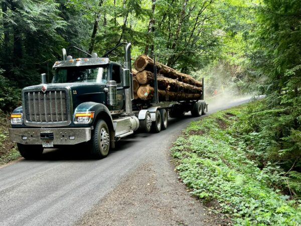
This is the Coast Range, where logging activity is common—so always be alert for logging trucks. Signs that trucks may be nearby include posted CB radio channels, mile markers painted on trees, fresh truck tracks, and well-maintained gravel roads.
We recommend riding single file, using a red rear blinky light and a white front blinky light, and avoiding earbuds or music so you can hear approaching vehicles. One of the best ways to detect a nearby truck is by sound. If a truck approaches—whether coming toward you or overtaking—stop and put a foot down. Don’t try to ride through. And remember, a friendly wave goes a long way.
For more information on this, check out our Timberlands Riding Etiquette page.
Route Options
Short Option
Turn around at the bridge at mile 7.2. Total distance: 14.5 miles. Total Elevation Gain: 650 feet.
Red Alder Alley + View Option
From the turn around point at mile 8.6, continue, climb and circumnavigate to a high point. In 1.3 miles you will climb 750 feet with an average gradient of 10.5%. We have not done this, but have mapped it. If you give it a go, take a picture, and let us know how the views are.
Long Option (Valsetz)
Ride out to the site of the historic logging town Valsetz (Valley + Siletz railroad). There are few remains of the town, but the ride is terrific. 47 miles, 3000 feet of gain. 80% gravel, 20% paved.
- GPX File: Download
Videos
The Ride! Alder & Iron
A quick 2+ minute video of what to expect on your ride.
Podcasts
Red Alder Trees
If you’ve ever cycled through Oregon, you might have passed under the canopy of Red Alder trees. In this episode, we chat with Glenn Ahrens, an extension forester from Oregon State University, about everything related to alders and conifers. We’ll also explore various tree [...]
Be Informed!
Keep it Local! Learn More

Related Guidebooks
-

All Access Gravel Guide Eastern Oregon (Collector’s Edition!)
$12.50Now shipping! A 64-page pocket-sized gravel guide. Featuring gravel routes, art, culture and local history. A one of a kind…Add to cart -

All Access Gravel Guide Western Oregon (Collector’s Edition!)
$12.50Now shipping! A 64-page pocket-sized gravel guide. Featuring gravel routes, art, culture and local history. A one of a kind…Add to cart
Ridden and Reviewed by:


Have you ridden this route? Got a question? Join the discussion!