Alto Ruins


Highlights & Remarkable Spots
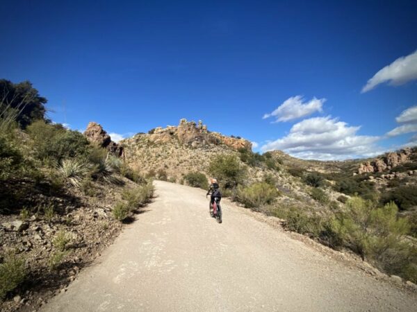
Miles 0 to 3 / Sonoita Creek / Gravel (mostly)
From the parking area, the lead-out is along a few paved side streets of Patagonia. Soon the pavement turns to hard-pack with fast, flat riding. Tall, burly oaks loom over you from above, tall grasses snuggle in from the sides. Along the way, you will pass by the Paton Center for Hummingbirds and the Patagonia-Sonoita Creek Preserve — “home to one of Arizona’s few permanently flowing streams, endangered fish, butterflies, and birds.”
In a verdant floodplain valley between the Patagonia and Santa Rita Mountains of southeastern Arizona, within the watershed of Sonoita Creek, lies some of the richest of the remaining riparian (streamside) habitat in the region. One of a few remaining permanent streams, it provides for a wide array of diverse species from endangered fishes to butterflies and birds.
The 873-acre preserve protects a magnificent example of the rare Fremont cottonwood-Goodding willow riparian forest. Some of the trees are among the largest (more than 100 feet tall) and oldest (130 years old) Fremont cottonwood trees in this country. This is one of the few remaining sites in Arizona where this once-common forest type persists. Arizona black walnut, velvet mesquite, velvet ash, netleaf hackberry, and various willows are found in slightly different habitats throughout the preserve.
Miles 3 to 13 / Hard Packed and Rolling / Gravel
Just after mile 3 and after a hard right, the route kicks up, and the terrain opens up. The landscape is of rolling hills, scattered trees, and high desert grasses. Then, the route drops down a bit, and after Hard Luck ranch at mile 4.4, it parallels a wash for just over a mile.
The route continues to climb until mile 7.5. Most of the climbing is moderate, but a one-mile stretch averages just over a 7% gradient. Be mindful that you are passing between private lands and public lands.
The next 4.5 miles trend downhill with several wake-up rollers [elevation loss 660 feet, gain 200 feet]. The route splits the south hills of the Santa Rita mountains [to the right] and the Grosvenor Hills [to the left], and directly in front of you is Mt. Hopkins with a white dot atop, the Fred Lawrence Whipple Observatory.
Much of this section is through the Salero Ranch. The roads are hard-packed and fast. At times … there is a bit of inlaid rock, giving the cobblestone ride feeling. At mile 12, the road pitches up for the climb to the ruins, 2.3 miles / 500 feet of gain.
Salero Ranch is a 16,000-acre cattle ranch, sandwiched between the Santa Rita Mountains to the north and Coal Mine Canyon and Sonoita Creek State Natural Area to the south. The Salero was part of the controversial Baca Float No. 3 land grant authorized by Congress in 1863 and has been privately held since that time; it also contains the ruins of some of the oldest silver mines in North America, dating back to the early 1700s or perhaps earlier. The current ranch owners run 200 head of cattle and have plated two-thirds of the ranch into 36-acre custom home sites.
Miles 13 to 14.4 / Rugged & Loose / Gravel
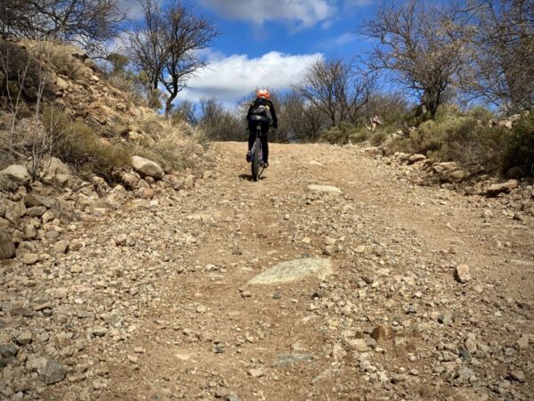
At mile 13, as you cross into the Coronado National Forest, the road quality deteriorates remarkably. It is steep, loose, and gnarly with cobbled rock.
Along the way, you will see signs to the right warning of No Trespassing – Mine Hazard area. From 2014 to 2016, there was a significant clean up by Asarco. “Remediation and reclamation activities included closing adits that were discharging acid rock drainage, remediating and reclaiming waste rock areas, closing evaporation ponds, and removing the acid rock drainage pipeline” [Reference: on-site signage]. At mile 14.4, veer left to the Alto Ruins. The destination!
Alto is a ghost town in Santa Cruz County, Arizona. In 1875 Joseph Goldree opened the Gold Tree Mine in the Alto area, which led to the establishment of a mining camp at the foot of the mountain. Apache raids were a constant threat in the early years, and as a result, it wasn’t until after the turn of the century that a town really began to take shape. A post office was first opened in 1907 in the home of a local pioneer named Josiah Bond, who was a former mining engineer, the local justice of the peace, school teacher, and poet. The adobe ruins of the Bond home and post office, which closed in 1933, are all that remains of Alto, apart from a small family cemetery and mine waste that was dumped over the mountainside.
Miles 14.4 to Finish / The Return / Gravel
Now reverse what you just did. Down the rugged and gnarly. Stop, look at the gravesite [~ mile 14.7 to the right]. Ride the fast, hard-packed roads through Salero ranch, splitting the Grosvenor Hills and the Santa Rita mountains. Climb the short steep pitch at mile 21. Descend into Patagonia with the big views of the Patagonia Mountains in the distance. And … finish up with 3 miles of fun, fast riding flats along Sonoita Creek. Then … go experience the town of Patagonia and drop some coin. Help keep these great gravel riding towns in business!
When We Like to Ride This
Fall through spring. Patagonia is a favorite area of ours on a warm winter day.
Terrain & Riding
There are several short steep pitches (over 10%). They can be walked and are not long. Near the end of the route, as you come to the Alto Ruins, the terrain becomes more loose and rocky.
The Start
Along McKeown Avenue which is adjacent to Patagonia Town Park. Flush toilets at the south end of the park.
Lat / Long: 31.538540, -110.756218
Food & Water
- None
Route Notes
This is mostly a 40 mm tire route. The last 1.4 miles to Alto Ruins is more rugged and loose. Doable on 40 mm tires with skill and confidence.
We recommend a red blinky light with rear looking radar detector (i.e. Garmin Varia)


Have you ridden this route? Got a question? Join the discussion!