Water & Lava


Caution! We do not provide turn-by-turn directions in our GPX files. Those are auto-generated by your bike computer and are usually less than 70% accurate. Learn more.
For help loading a GPX file onto your bike computer, go here.
DownloadHighlights & Remarkable Spots
Old Haul Road / ~ miles 1.5 to 5
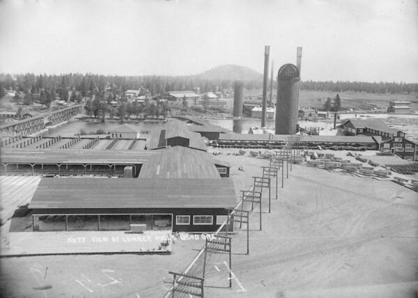
These miles follow along the old haul road, a historic railroad logging route that was used to transport logged trees to the Brooks-Scanlon and Shevlin-Hixon mills, located along the Deschutes River near the Old Mill shopping area today. The rail lines were used in place of the river on this segment due to the number of cascades and falls. Picture – Shevlin-Hixon Mill on the west bank of the river. [Old Mill District]
Deschutes River (Lava Island Falls to Benham Falls) / ~ miles 1.5 to 7
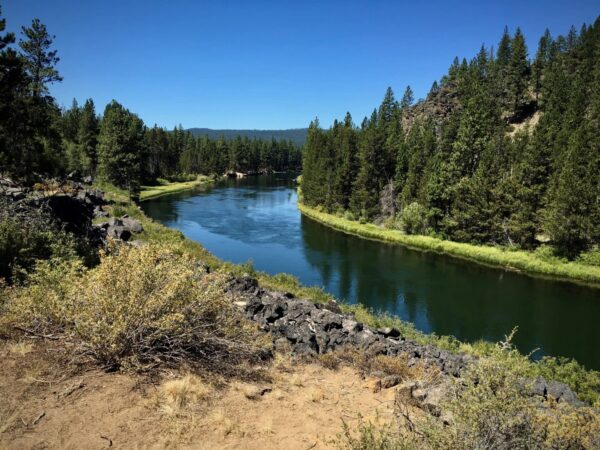
“The Deschutes River is a major tributary of the Columbia River. The river provides much of the drainage on the eastern side of the Cascade Range in Oregon, gathering many of the tributaries that descend from the drier, eastern flank of the mountains. The Deschutes provided an important route to and from the Columbia for Native Americans for thousands of years, and then in the 19th century for pioneers on the Oregon Trail. The river flows mostly through rugged and arid country, and its valley provides a cultural heart for central Oregon.” [Wikipedia]
Ryan Ranch Meadow / ~ mile 4
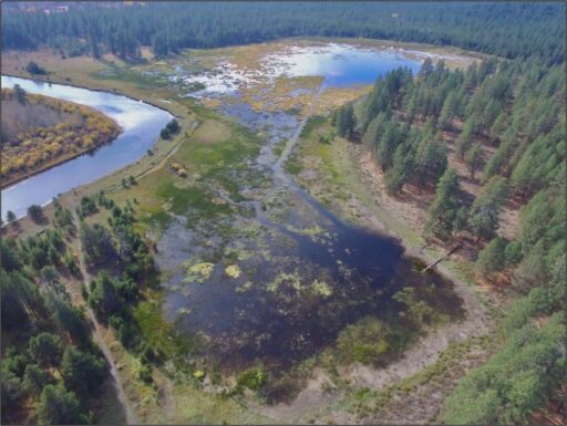
“Ryan Ranch is a historic slough floodplain of the Deschutes River that has been drained and isolated from the river for over 90 years. The area was used historically by Native Americans and more recently as pasture after being homesteaded in the late 1900’s. The Forest Service acquired Ryan Ranch in 1946 and continued grazing on site as part of a federal grazing allotment until 1989. The full ecological potential of the slough, including historic habitat for the Oregon spotted frog, has been limited by a berm that prevents the river from inundating the floodplain on a regular basis. Reconnecting the river with Ryan Ranch will benefit a wide range of terrestrial and aquatic species, including migratory and nesting waterfowl, amphibians and ungulates.” [USDA]
Benham Falls / ~ mile 7
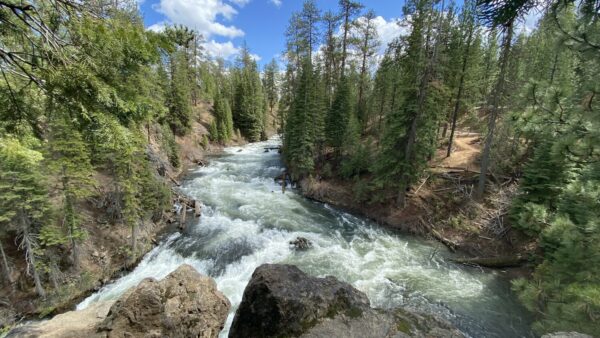
Benham Falls are rapids of the Deschutes River located between Sunriver and Bend, Oregon. With a pitch of 22.5°, they are rated Class 5 for watercraft and are the largest falls on the upper Deschutes. The falls were created by the eruption of nearby Lava Butte approximately 6,000 years ago, as the lava flow dammed the Deschutes, forming a lake known as Lake Benham. The river eventually flowed over the dam, draining the lake and thus forming Benham Falls. Around 1885, J. R. Benham attempted and failed to file a land claim near the falls, though they were later named for him. [Visit Bend]
Lava Butte / ~ mile 13
Lava Butte is a cinder cone in Central Oregon, between the towns of Bend and Sunriver. It is part of a system of small cinder cones on the northwest flank of Newberry Volcano, a massive shield volcano that rises to the southeast. The cinder cone is capped by a crater that extends about 60 feet deep beneath its south rim, and 160 feet deep from the 5,020-foot summit on its north side. [Wikipedia]
Deschutes River Viewpoint / ~ mile 23
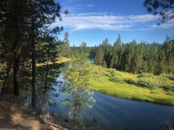
Below Sunriver, the vegetation changes to old-growth ponderosa and aspen, and shorelines vary from marshy meadows to basalt bedrock. Flows fluctuate less because of tributaries, and the river features many deep pools, a more stable bank, and a rocky in-stream structure. [ US Forest Service]
Credits & Acknowledgements
This ride guide is funded in part by Visit Bend.

When We Like to Ride This
The exceptional times are spring when the flowers bloom and the river runs full and fast and fall when the leaves are changing color. But, do not forego this ride if you visit in the summer. Some of the paths will be a bit busier, but it is still very worthwhile, especially for a family.
Terrain & Riding
A fun out and back ride that starts close to town. Don’t let the proximity to civilization fool you – once you’re out there, you’ll feel like you’re miles away from civilization. We have even seen owls, elk, deer and coyotes in this area!
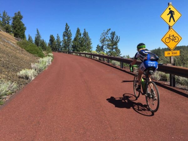
With a good mix of single track, double track, gravel roads, and paved bike paths, this route is perfect for anyone who wants to experience a variety of terrain types. The terrain is open ponderosa pine forests with views of the river, including basalt columns and marshy meadows, and a short, steep climb up to Lava Lands Visitor Center that is well worth the 1 mile of 8% grade!
The Start
The Cascade Lakes Welcome center on Cascade Lakes Highway. Water & toilets.
Food & Water
- ~ mile 12 at Lava Lands Visitor Center. Fodd, water, & flush toilets. Open seasonally.
Route Notes
We recommend a red blinky light with rear looking radar detector (i.e. Garmin Varia)
Route Options
Family Friendly Vesion
For a family friendly version of the ride, start at the Aspen Day Use area. From here, ride out to the Lava Lands Visitor Center and then retrace your way back to the start. This will give a ride of just over 15 miles, with 600 feet of total elevation gain. You will need a Forest Service parking permit for the Aspen Day Use area which can be purchased at the Cascade Lakes Welcome Center at the intersection of the Cascade Lakes Highway and Conklin Road (FS 41).
– Aspen Day Use area Lat / Long: 43.969807, -121.415205
– Cascade Lakes Welcome center Lat / Long: 43.998223, -121.405697
Longer Version with More Bike Path
For a longer version of the route, start at the Loge on Century Drive. Take the paved bike path from the Loge to the Cascade Lakes Welcome center. This adds 6.4 miles and 250 feet of gain (in total). The Loge has an excellent cafe for a pre-ride coffee and a pastry, and it also has a taproom for that after ride beer!
Avoid the Single-Track
All of the single-track on this route can be avoided.
- Miles 0 to 0.6: Use Conklin Rd / NF-41 and then go left on the gravel road towards Lava Island Day use area to intersect the route at mile 0.6.
- Miles 2.1 to 3.0. At mile 2.1, go left on the gravel road. At the very next intersection, go left again to intersect the route at mile 3.0.
- Miles 18.3 to 22.8. Delete this section of the course. Instead, at mile 18.3, continue straight and back across the wooden bridge over the Deschutes river.
More Single-Track
If you want more single-track, we recommend the Black Rock Trail. It parallels the paved path from miles 8.3 to 11.5. (Change to the RWGPS view in the upper right of the map to see this alternative.) Some like to ride up this trail in lieu of the paved bike path; others like to ride down it instead of the paved road. (That is Captain O’s preference.)
Sunriver Option with Coffee (or beer!)
When you reach the northern edge of Sunriver, there is an option to get a coffee (we recommend Brewed Awakenings) or to get lunch (we recommend Cafe Sintra). This adds an additional 11.5 miles with 250 feet of gain. Good luck navigating the roundabouts to the main plaza, but we have put together a map for you. (GPX File / TCX File) The route we have chosen loops you through Sunriver on the most scenic bike paths. We have not included turn-by-turn directions as there are a zillion turns and roundabouts in Sunriver. Also, stay on the bike paths and control your speed. Do not ride the roads, and if you do, risk that infamous ticket.
Love Where You Ride! Learn More
 This route really highlights the upper Deschutes River, a natural jewel in the heart of the Central Oregon community. But many of us are unaware that the river upstream of Bend is in big trouble. Its ecology is at a tipping point and showing steep declines in fish, wildlife and vegetation. We must act now before it is too late. Take a moment to learn more on the Deschutes River Conservancy website.
Videos
Act Now to Save the Deschutes River
A 2-minute video detailing the threats to the river and what we can do to help. Get educated and advocate!
Podcasts
Ryan Ranch Meadows
Ryan Ranch area was homesteaded in the 1890s. In the 1920s a berm along the Deschutes River was constructed to keep the river from flooding valuable pasture land. Prior to this, the area historically functioned as an emergent freshwater marsh that was connected to surface flows from the [...]
Keep it Local! Learn More

Outfitters
Ridden and Reviewed by:


 Behind every route is scouting, mapping, storytelling, and a whole lot of pedal power.
Have you ridden this route? Got a question? Join the discussion!