Discovery


Highlights & Remarkable Spots
Gnomes on the E.L.V. Trail / ~ Mile 6
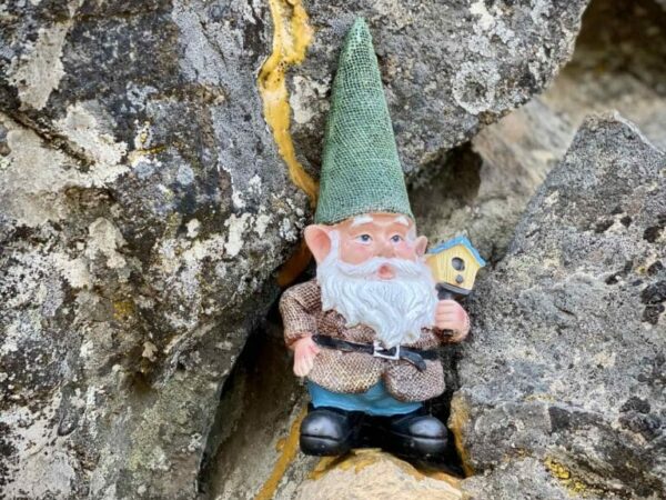
E.L.V. is the mountain biking trail named after Eric L. Vickers, past president of COTA. Eric originally built the E.L.V. trail and upon completion wanted to include an elf statue along the trail to protect future riders. Unable to find an elf anywhere in Bend, a friend stumbled upon an 18lb concrete gnome in a thrift store in Portland and brought it back to Eric who then secured it to a stump along E.L.V. The gnome stood guard on the trail for a few years until the Forest Service decided to remove it. Afterwich local riders began to hide multiple smaller gnomes all along the trail. By our last count, there are more than 10 along the trail, how many can you find??
The Flaming Chicken / ~ Mile 7.5
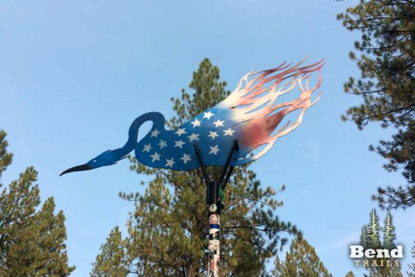
The artwork known as “Phoenix Rising,” created by Frank Boyden in 2002, has become a significant landmark in Bend’s history of public art installations. Although the artist intended for it to be referred to as “Phoenix Rising,” the local community has affectionately adopted the moniker “Flaming Chicken,” originating as an insult but now widely embraced. A miniature version of the piece, frequently adorned with Mardi Gras beads, can also be seen at a prominent intersection (KGB, Phil’s Trail, and Expressway) within the Phil’s Trail complex. This unique piece stands as a testament to the evolution of public perception and the enduring impact of public art.
Phil's Trails / ~ Mile 9.5
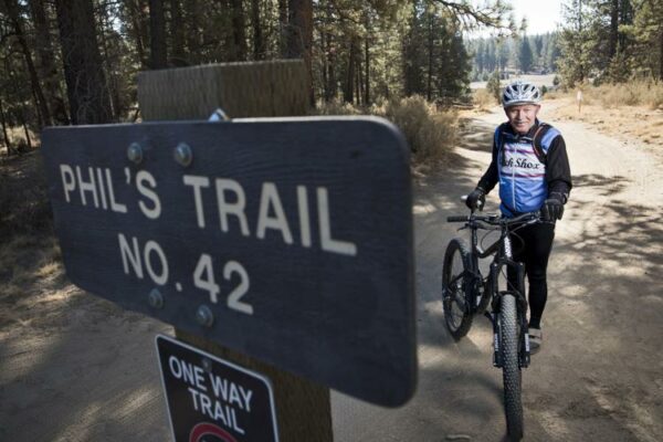
Phil’s Trails are a nationally renowned mountain biking destination. It began as a simple deer trail in the late 1970s and early 1980s, discovered and ridden by pioneers of mountain biking in Central Oregon, including Phil Meglasson. Today, the Phil’s Trail Network is maintained by the Central Oregon Trail Alliance and comprises a wide variety of singletrack options, attracting over 10,000 mountain bikers annually. Phil’s Trail serves as a testament to the persistence and hard work of early mountain biking pioneers and COTA who transformed USFS and BLM land into a world-renowned biking destination.
Bridge Creek Water Supply System / ~ Mile 11.8
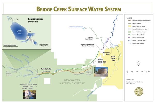
Bend has relied on groundwater and surface water to supply drinking water to local taps since 1926. These aging pipelines required replacement. The $70 million Bridge Creek Water Supply and Treatment Plant project (circa 2015) included a 10-mile-long, 30-inch pipeline installed underneath Skyliners Road (which you’ll be crossing over at mile 15). The intake at Bridge Creek, near Tumalo Falls, is the highest operating intake in the Northwest. The intake building addresses seismic risk and fire protection. Pumps send heated water to the intake screen to prevent frazil ice buildup—a design first in the state of Oregon. Intake controls allow the City to reduce diversion when water is not needed, helping to maintain healthy fish habitat. The new automated Outback Water filtration facility (near FS 4606 and Skyliners) guarantees 10 million gallons of water per day to City residents.
Women of Discovery Mural / ~ Mile 16.5
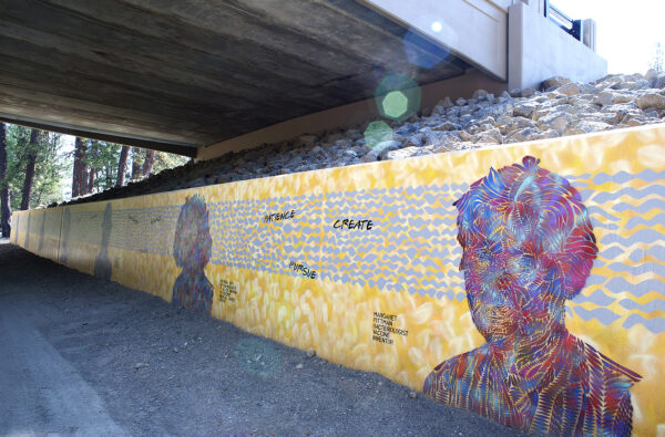
A hidden gem of Skyline Ranch Road, where local artist Douglas Robertson has added a brilliant touch to the retaining walls under the bridge. Doug’s imaginative mural “Women of Discovery” showcases his intricate stencil work, vibrant color choices, and expert spray painting technique. Take a strop along the trail and be inspired by the trailblazing women of history who grace the walls. Fun little fact, all the women featured in the mural, are also honored with street names of the surrounding housing development.
Discovery Park Community Garden / ~ Mile 16.7

In 2019, the Community Garden at Northwest Crossing’s Discovery Park became a valuable asset of the Bend Park and Recreation district. The garden is sustained by the expertise of the Oregon State University Extension Service and OSU Master Gardeners, who provide personalized support and a range of classes to gardeners throughout the growing season which begins in April. The 51-bed garden offers a rare opportunity for individuals with limited space to cultivate their own flowers and vegetables, and to become a part of the larger gardening community. This area represents a unique and enriching resource for the local community.
When We Like to Ride This
Mid-spring thru late fall. Spring and fall conditions are best, the ground is still retaining moisture, and the trails are tacky, giving good grip. In summer, the dirt can take on the texture of moon dust, making for loose corners.
Terrain & Riding
The route starts in Discovery Park and consists of a mixture of paved roads, bike paths, double-track, single-track, and forest service roads. The first mile of the route is paved road and bike path leading to the Cascade Highlands connector, a wide gravel/dirt path that is fun and easy to ride but be careful as there are other users on the path. (Share the trail and remember that cyclists give way to all other users.)
At ~ mile 2.7, connect into the Phil’s network of single-track trails for 9 miles, which are fun, fast, and flowy — a great gravel bike experience. And as Gravel Girl would say, “a sneaky way” to work those technical skills. The route is Marvin’s Garden to ELV to Lower Phils to Bens. By connecting the trails in this sequence, you have a bit of up, a bit of down, and a bit more of up. It is all rated mountain bike easy to easy-intermediate and completely rideable on a gravel bike. There are a few short technical sections with a bit of rock. It is absolutely ok to put a foot down or walk the 10 yards.
Along the ELV section, look for the elves / gnomes along the trail. How many did you find? There are way more than 10! And … what is the difference between an elf and a gnome?
The last 5 miles use a variety of trails and paths to connect back to Discovery Park, including a single-track trail through a small canyon, an old decommissioned forest service road, and the “Nordic Sue” single-track connector. The last segment includes a short, challenging 8% ascent connecting with a paved path, followed by a dirt trail back to Discovery Park.
The terrain is mostly pine forest with some peek-a-boo mountain views.
The Start
Discovery Park pavillion. Flush toilets and water nearby. On-street parking.
Food & Water
- None.
Route Notes
For current single-track trail conditions, see the Bend Trails page. (They do a bang-up job with trail conditions!)
Many of the trails along the route are multi-use. Walkers, those with little kids, etc., have priority. Be courteous. Stop and put a foot down if need be. Do not ride off the side of the trail as this widens single-track into double track. A no-no! Also, uphill riders have the right of way. Downhill riders must give way. In general, if you are heading east towards the parking lot, you are going downhill.
Love Where You Ride! Learn More
 Near the end of the ride, there is a mural along the paved path titled Woman of Discovery. We would encourage you to stop and really take a close look at the piece. Hopefully, it will inspire you. To learn more about public art in Bend, check out Art in Public Places.
Videos
The Ride! Discovery
A quick 2-minute video of what to expect on your ride!
Podcasts
ELV and Those Gnomes
Have you ever wondered about the backstory of the gnomes on the ELV trail in Bend, Oregon. Eric L Vickers talks a bit about how this all happened. Did you make the connection? ELV. Eric L Vickers.
Phoenix Rising or Red Chicken
We all know about the iconic psuedo “Red Chicken” sculpture within the Phil’s Trail System which is a mountain biking area in Bend, Oregon. But … do you know the story of the actual sculpture, the Phoenix Rising, located at Galveston and 14th street? And what’s [...]
Women of Discovery (The story of a mural)
Hear from the artist Douglas Robertson who created the mural of Women of Discovery near Discovery Park on the west side of Bend, Oregon. What was the inspiration for the piece? How was the work done? Where can you [...]
Be Informed!
Keep it Local! Learn More

Ridden and Reviewed by:


Have you ridden this route? Got a question? Join the discussion!