Ruby South
The ghost town of Ruby is now closed to public access as of June 2024. The ride as documented still “goes”.


Caution! We do not provide turn-by-turn directions in our GPX files. Those are auto-generated by your bike computer and are usually less than 70% accurate. Learn more.
For help loading a GPX file onto your bike computer, go here.
DownloadHighlights & Remarkable Spots
The Atascosa Highlands / ~ Mile 5
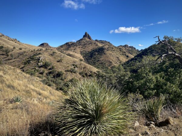
The Atascosa Highlands is an area of incredible biological diversity located within one of the most ecologically rich regions on the planet. Taking up less than 1% of Arizona’s overall landmass, the Atascosas host at least half of the state’s total bird species and approximately one-quarter of its flora, including several species which are found nowhere else in the United States. [Atascosa Borderlands Project]
The Ghost Town of Ruby / ~ Mile 15
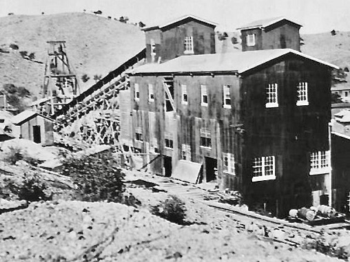
The first Europeans to visit the Ruby area were Spanish conquistadors in the late 1500s. In the 19th century, the region was referred to as “Oro Blanco,” or white gold, after a distinctive light-colored strain. Later, as colonists moved west, there was an influx of adventurers, mountain men, ranchers and miners. The first strike in the Montana’s vein was in the late 1870s, and by the turn of the century, the town of Ruby had become the largest mining camp in the area. Ruby was once the largest lead and zinc producing mine in the state of Arizona. [More info]
Mexican Free Tail Bats / ~ Mile 15
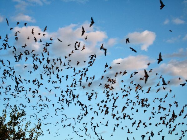
A colony of Mexican Free Tail Bats inhabits Ruby’s abandoned mine shafts from May to September each year. Estimates of the colony range from 90,000 to as high as 150,000 animals, representing a nightly appetite for up to a 1/2 ton of insects. This is considered a maternal colony, and they produce their young in June and leave for parts south in late August. Contact the caretaker at Ruby to make arrangements to see this sight.
When We Like to Ride This
Late fall to early spring when the skies are clear and the temps are moderate. We would avoid this route in summer as it is very exposed to the sun. Wind could also make this route brutal. Do the route when the ghost town of Ruby is open for touring, otherwise the turn around point will feel a bit anticlimactic.
Terrain & Riding
Leading out, the route quickly crosses Pena Blanca wash and then wastes no time in climbing up and out of Alamo Canyon, with grades of 6 to 12%. Alamo Canyon slowly disappears to your left while you continue to gain elevation in an attempt to “top” the ridge amongst dispersed and jagged walls of rock to your right. The riding is never “easy”; there is washboard, some rock-cobbled sections, and short downhills requiring your attention.
We loved the plant life: blooming yuccas and open grasslands. (Thorn-scrub and Pinyon-Juniper woodlands of the Sonoran desert.) Once the ridge is attained, you will have an eagle’s view of the whole area and layered views of distant mountain ranges to the north and south. Immediately to the north are the Atascosa Mountains, and immediately to the south are the Pajarito Mountains. Roll along on the ridge, enjoy the views, then pop down, down into large oak and sycamore trees, cross a wash. This is the entrance to Sycamore Canyon.
Now climb again, more grand open views, with “loads” of steep-faced rock formations. At ~ mile 9, the terrain becomes less mountainous, replaced by rolling grasslands with Bear Valley to your right. Then, unexpectedly, the road twists and turns. Montana Peak appears to your left, and road drops down (again!) to the town of Ruby, where hopefully you have been smart enough to reserve a time to tour the place.
The way back is about equal to the way out, with 300 feet less elevation gain but a steeper climb to the high point (a consistent grade of 8% for 950 feet of gain). The only real surprise was somehow, we thought at mile 23 or so that we were done climbing. Not the case. You wind, wind down … but for grins, there are a few poppers that jump you back to 8%. Let’s just say you have been warned, and we do hope you find the humor in these short segments.
The Start
White Rock Campground. Pit toilets.
As your drive in, with the lake in sight, there is a sign for camping to your left. This is the gravel road for your ride; don’t keep going down to the lake. Park at the campground, the campground is a round circular lot. To start your ride, continue west on the gravel road (FS 39 / Ruby road) when leading out, it will feel like you are cutting through the back of the campground. Your not. In a few hundred feet, you will realize that “yes, indeed” you are on a road that goes somewhere. To Ruby!
Food & Water
- None
Route Notes
This route has a completely different character than Ruby (North). Ruby (North) is much more of an exploration of washes, canyons, and gulches. Ruby (South), this route, is tucked up alongside the Atascosa Mountains and has wide, sweeping views for most of the day. We strongly recommend both routes. And … if your into “big”, give Big Ruby a go. It takes in the best of both routes.
Regarding Border Patrol. When we come across them for the first time in the day, we stop and ask if “there’s anything we should be aware of,” and we also gave them our route for the day. With us Border Patrol has always been professional, helpful and polite.
45 mm tires are about the minimum for this route. 650b’s with 50 mm tires or a 29’er with 2.1’s would be our preferred choice.
Route Options
For a slightly longer ride, start at Calabasas group campground on Highway 289. This will add 6 miles (total) of rolling pavement with an extra 825 feet of gain. Lat / Long: 31.387898, -111.051128
Love Where You Ride! Learn More
This ride entirely within the Atascosa Highlands COA (Conservation Opportunity Area). These region has been identified by Arizona Game & Fish for its significant ecological value, where targeted conservation efforts can effectively preserve and enhance biodiversity. The Atascosa Highlands COA encompasses three mountain ranges—Tumacacori, Atascosa, and Pajarito—located just west of Nogales, Arizona.
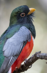
Within the COA are Sycamore Canyon and California Gulch. Sycamore Canyon boasts up to 95 breeding bird species, one of the highest breeding bird diversity concentrations in Arizona. California Gulch is unique with quality thornscrub habitat, a dense shrub layer on its steep sides, and a perennial spring-fed stream. Both canyons support several Mexican species that are rare in the United States, such as elegant trogon and Rivoli’s hummingbird. This area is also an important dispersal area for Mexican breeding populations of jaguar.
We ask that you treat this area with the utmost respect: tread lightly and watch from a distance!
Ridden and Reviewed by:


 Behind every route is scouting, mapping, storytelling, and a whole lot of pedal power.
Have you ridden this route? Got a question? Join the discussion!