Old Blewett


Caution! We do not provide turn-by-turn directions in our GPX files. Those are auto-generated by your bike computer and are usually less than 70% accurate. Learn more.
For help loading a GPX file onto your bike computer, go here.
DownloadHighlights & Remarkable Spots
The Historic Town of Blewett / Just North of Mile 0
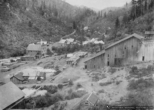
As you drive north of the start by 1.6 miles on Highway 97, there is roadside kiosk on the east side of the road marking the site of the old ghost town of Blewett.
In 1860 gold was discovered in the nearby creeks. Soon 200 to 300 people lived and worked in the narrow valley. By early 1874 placer mining had played out, but veins of gold had been found. This brought a boom of hard rock mining with thousands of feet of tunnels burrowed into the hills. By 1879 the mining district was connected to the outside world via the Blewett Pass road.
The town (originally named Warner) tooks its name after Edward Blewett of Seattle, whose gold mining company controlled many of the claims. Buildings included a school, a two-story hotel and boarding house, stores, saloon, and a telegraph station. [Western Mining History]
Old Blewett Pass / ~ Mile 6
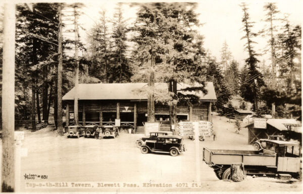
This is the original pass and roadway connecting Cle Elum to Peshastin / Wenatchee. The summit of the old Blewett Pass highway was a popular stop for travellers in the 1920s. This 1922 photo shows the Top-O-the-Hill Lodge that offered ice cream and cold drinks. The old section of road (part of which you ride) has over 57 turns, steep hillsides, lack of guard rails and narrow width. [Sunset Highway]
Mt Stuart & Enchantments / ~ Mile 15 & Mile 20
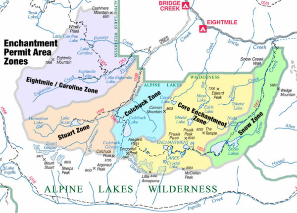
Mt. Stuart is the second tallest non-volcanic peak in the state at 9,415 feet and said to be a solid chunk of granite. The combination of high elevation, good rock, and steep faces makes it one of the most popular multi-pitch rock climbs in the state. In the middle of the Stuart range is a high alpine plateau called the Enchantment Basin, home to about ten small lakes that are frozen most of the year. Surrounding these lakes are several high peaks, known as the Enchantment Peaks including Colchuck Peak, Dragontail Peak, Prusik Peak, and Little Annapurna. [Mountain Zone]
Lion Gulch Meadow / ~ Mile 15.8
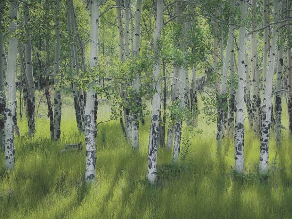
To your right you will see an open, high-alpine meadow with some mature aspen trees. Aspen is noted for its ability to regenerate vegetatively by shoots and suckers arising along its long lateral roots. Root sprouting results in many genetically identical trees, in aggregate called a “clone”. All the trees in a clone have identical characteristics and share a root structure. Aspen clones can be less than an acre and up to 100 acres in size. Even though the individual aspen trees may not very be old, aspen clones can be hundreds of years old. The oldest known aspen clone has lived more than 80,000 years on Utah’s Fishlake National Forest. [US Forest Service]
Diamond Head / ~ Mile 18
Diamond Head with its majestic western ledges and towers over Blewett Pass and is noted as the trademark of the pass. The north and south summit have amazing views of the Enchantments to the west and the more rounded Wenatchee Mountains to the east. In fall this is the ideal peak for fall colors because there are large amount of larch in the area that change in October. [Summit Post]
Blewett Pass (Swauk Pass) / ~ Mile 20
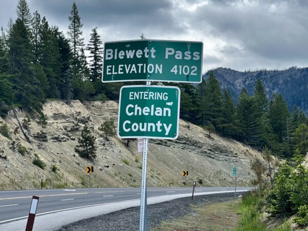
In the 1956, the old 1920s roadway highway was rerouted over Swauk Pass 4 ½ miles east of Blewett Pass. The pass was 30 feet higher, 4071 feet vs. 4102 feet, but the grade was much less. Thus, the highway no longer crossed Blewett Pass. From ~1960 on, the crossing was confusingly referred to in print, and in highway signage, as Swauk-Blewett Pass, or Blewett-Swauk Pass. In 1990, to end the confusion, WSDOT officially changed the name to Swauk Pass. That was when the U.S. Board on Geographic Names got involved and took formal action. In 1992 Swauk Pass was officially renamed Blewett Pass, and what had been Blewett Pass officially became Old Blewett Pass. [Kiro News Radio]
Mining Claims / ~ Miles 22 to 28
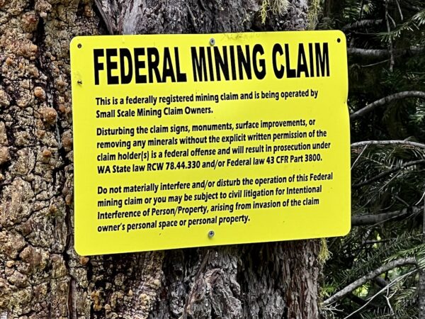
Along this sector of the route you will see a number of different mining claim signs tacked onto trees. Within the Blewett Mining District there are 96 nearby claims — 72 active and 24 closed — and 112 nearby mines. In the 1860s through the 1870s there was a gold rush to this area which first started as placer mining and eventually moved into tunneling and hard rock mining. Today, the area is mined by individuals and private mining clubs like the Bedrock Prospectors.
Pat King Gravesite / ~ Mile 26.5
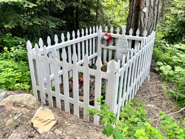
The historical legend most often told is that Pat King was providing supplies to the nearby miners via wagon. When the rear axle of the wagon broke, he jacked it up via long poles and propped it up by blocks to commence repairs. The wagon slipped off the blocks, pinning King underneath, crushing him to death. [Wenatchee Area Genealogy Society]
When We Like to Ride This
Spring after the snow melts out (the peak elevation of the route is 5000 feet) through fall. We like early summer for the creeks running full, the green grasses, and wildflowers. Fall offers up a spectacular change in colors with the mix of deciduous and pine trees.
Terrain & Riding
THE TERRAIN
This ride is up and down and around the Wenatchee mountains, a major sub-range of the Cascades. The terrain is forested with numerous mountain meadows and creeks. There are variety of pine trees including Ponderosa, Douglas Fir, Grand Fir, Western White Pine, and Western Larch. Along the meadows, there a pockets of poplars. (To learn more about the tree types make sure to do the Swauk Discovery hike — see the sidebar “Love Where You Ride”).
There will be vista views, some of which have opened up due to logging and fire. The rugged granite peaks of the Enchantments will show several times along the ride including including Mt. Stuart (which our co-founder Kevin English has climbed).
THE RIDING
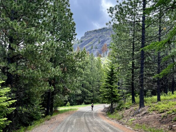
Miles 0 to 10 are on the old Blewett highway, expect a rough, beaten, narrow paved road that has seen little upkeep over the years. Perfect for a gravel bike! There are dips, gravel potholes, wide cracks and possibly some rock and tree debris. The climb up is 1500 feet in 6 miles. The up and down gradients do not vary much, usually in the range of 4 to 6%. Use caution when descending and be careful not to override your sight line.
Miles 10 to 20 are on hard-packed Forest Service dirt road. The up gradient is a bit steeper than that of the Old Blewett Highway (at 4 to 8%), but again very consistent. The climb is also a bit longer, at nearly 2000 feet of gain. The descent back to Highway 97 is a bit more undulating with several “flats”, but never much steeper than 8%.
Miles 20 to 27 are on Scotty’s Road, the most primitive road of the day. It is mostly single-lane, dirt and gravel rock, steep in spots (10% down gradient), and the upper third being rutted from winter runoff. This will be the most technical riding of the day.
You will cross Highway 97 twice. At ~ miles 10 and 20. It is a direct 90 degree crossing. Be patient and use caution.
The Start
There are a number of dirt pull-outs on Old Blewett Pass road as you exit of Highway 97. We like the first one on your right along the river before the bridge.
Food & Water
- None
Route Notes
Recommend riding in the direction as mapped and documented here (counter-clockwise). The reverse direction has a longer sustained initial climb on a road that is more primitive, rutted and loose. 2600 feet of gain over 11 miles.
Exercise patience and caution when crossing Highway 97.
The Swauk Discovery Trail could use some Trail Love. If you are interested in working with us to restore signage along the route and to update the information brochure to reflect current forest management practices, send us an email.
Route Options
- This route can be combined with the Liberty route (guide coming soon!) to make for a big loop of 58 miles and 8100 feet of gain. GPX Download
- If you’re looking for an option with more gravel, give the Shaser Option a try. Instead of climbing Old Blewett road it climbs Shaser road. You still descend from Old Blewett Pass on pavement. 30 miles and 4000 feet of gain. (GPX Download)
Love Where You Ride! Learn More
 The more we ride, the more we want to know about the lands we are riding through. The plants. The trees. The mountains and hills. At ~ mile 20 along the ride there is the Swauk Discovery Trail. It is an interpretive trail detailing the different pine trees of the forest.
This associated brochure that goes with the trail (print or save to your phone) also details the “best” forest management practices of the 1990s. The science and research may have changed since then, and these practices may no longer be the “best practices”, but historically it is important to understand past practices in the larger context of current forest management.
We encourage you to do this simple 3-mile hike the day before or after your ride, or even make it part of your ride.
Videos
The Ride! Old Blewett
A quick 2-minute video of what to expect on your ride!
The Astonishing Underground Life of Aspen Trees!
The Aspen Tree. The coolest tree ever? Groves clone themselves! Groves can be hundreds, if not thousands of years old. This 7-minute video explores the uniqueness of the Aspen Tree via the Pando clone in Utah that is approximately 80,000 years old.
Keep it Local! Learn More

Ridden and Reviewed by:


 Behind every route is scouting, mapping, storytelling, and a whole lot of pedal power.
Have you ridden this route? Got a question? Join the discussion!