Dirty Freehub
Favorites Sign In Search
  • Search
  • Donate
  • Gravel Routes
    • Explore by Region
    • Explore by Type
    • Explore by Collection
  • All Access®
  • Stories
    • Bike Life
    • Culture & History
      • Central Oregon
      • NE Oregon
      • Bend Trails
      • Death Valley
    • People & Places
    • Lands
      • Arizona
      • Central Oregon
      • NE Oregon
    • Love Where You Ride
  • Events
  • User Guide
    • Route Types
    • How We Rate Routes
    • Using the Map
    • Loading a GPX File
    • Glossary
    • FAQs
  • Inside DF
    • The Team
    • Our Missions
    • Impact Reports
    • Press
    • Sponsors
  • Store
    • Gravel Guides
    • Merch
  • Donate
  • Cart
  • Sign In
  • Favorites

Klickitat Trail

5 Star Route / Hood River, Washington / Published: Mar 2021 / Updated: May 2025 / Directions
Save to Favorites Remove from Favorites

The Swale Canyon segment of the Klickitat Rail Trail is closed annually from ~ June 21 through October 8 for fire season. See Notes & Options tab for alternative rotue.

Gravel Girl leading out on the Klickitat Trail near Lyle, Washington.
Leading out! The Klickitat River segment. / March 2021
Cyclists overlooking the bridge at Fischer HIll Trestle.
The Fischer Hill Trestle / Bridge, ~ mile 1.6
The view downriver of the Klickitat from the Fischer HIll Trestle near Lyle, WA.
Cyclist on the rough railroad bed rock of the Klickitat Trail.
At ~ mile 2, the route gets more chunky and burly.
Gravel Girl riding over a bridge near the Klickitat River.
Woman cyclist on single track portion of the Klickitat Trail.
Gravel Girl on the single track near the Klickitat River.
The double-track portion of the Klickitat Trail approaching the town of Klickitat.
Cyclists passing through one of the several gates along the Klickitat Trail.
There are several gates along the way. Please close as marked.
Grassy path with gravel cyclists near Lyle, Washington.
Sign for the town of Klickitat.
The town of Klickitat, ~ mile 13.
Cyclist on Highway 142 just north of the town of Klickitat, but paralleling the river.
The beginning of the Swale Canyon portion of the trail.
The beginning of the Swale Canyon sector, ~ mile 16.5
Cyclists crossing over an old railroad trestle bridge on the Klickitat Trail.
Woman cyclist on the rough section of the Swale Canyon trail.
One of the filled in trestle bridges along the Swale Canyon trail near Goldendale, WA.
Cyclists on the section of the Swale Canyon trail nears Harms road.
A group of gravel cyclists on Harms road near Centerville, Washington.
Onto good gravel, Harms Rd, ~ mile 28.
Cyclist riding on the Centerville Highway near High Prairie.
The Centerville Highway sector, miles 29 to 44.
Woman cyclist climbing a small hill along the Centerville Highway near High Prairie, Washington.
An old rustic barn along the Centerville Highway in Washington.
Two women cyclists about to descend the Centerville Highway into Lyle, WA.
Get ready for the long continous downhill. Fun!
Expansive view from cyclists perspective as descending the Highway 142.
Mt Hood
A view of the confluence of the Klickitat and Columbia Rivers.
The parking lot in Lyle for the Klickitat Trail.
The parking area.
Gravel Girl's ride metrics for the Klickitat Trail route on Dirty Freehub.
Gravel Girl's ride metrics.
*
Route:
Loop | 44 mi
*
Gain:
2,400 ft
*
Surface:
60% gravel / double-track, 40% paved
*
Technical Difficulty:
Moderate
*
Navigation:
Attention Required
*
Locale:
Rural
*
Tire Suggestion:
50 mm+
*
Options:
Longer

This route is a fascinating blend of history, environment, and stunning views; it includes a river-hugging, rocky trail that uses an old railroad bed (no whining!), rolling farmland, and a rip-roaring paved downhill with a bird’s eye view of the Columbia River. Some of you will love it, some of you will hate it. It all depends on how well you can tune out the rocky sections and focus on the amazing scenery.

To fully appreciate the route, we hope you study up: good ole Lewis and Clark on one of their famous expeditions bumped into about 700 Klickitat Indians living in this area during their 1805 expedition. There was the Klickitat Pop Company which made carbonated beverages … and then, of course, the railroad (now the trail) that was put in during 1903.

This is a must do ride for the history and beauty, but it is not a ride that we would venture out onto more than once every several years due to the rough texture.

Read More
Map
Brown = gravel / dirt road
Blue = single track
Red = paved road
Purple = paved bike path
GPX Download   Version 1.0

Highlights & Remarkable Spots

Wild & Scenic Klickitat River

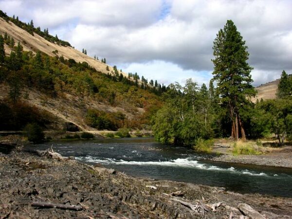
The lowermost 10.8 miles of the Klickitat River, from Wheeler Creek to the confluence with Columbia River, are designated as a Wild & Scenic River. This stretch of river begins as a broad canyon with rolling hills that drops at a steady gradient of 26 feet per mile before cascading into a Class V gorge around river mile 2 with an unrunnable entrance feature.

The Yakama Nation have been dip-net fishing continuously in this area for generations to catch salmon and steelhead. Please share the river with respect. [US Forest Service]

The Railroad

Seattle Portland Railway

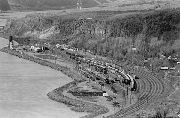
In 1903 the Spokane, Portland, and Seattle Railroad built the original railroad linking Lyle and Goldendale to transport crops, lumber, and livestock. Passenger service existed for several years during the 1920s between Portland, Oregon and Goldendale, Washington. Lumber was king, and the railroad was an important part of its transport until the 1980s. It was discontinued in 1992 following the decline of the lumber mill in the town of Klickitat and the mill in Goldendale. The railroad right of way was purchased in 1993 by the national Rail-to-Trails Conservancy…. [Kiosk at the Wahkiacus trailhead]

Klickitat Mineral Springs

Klickitat Mineral Springs

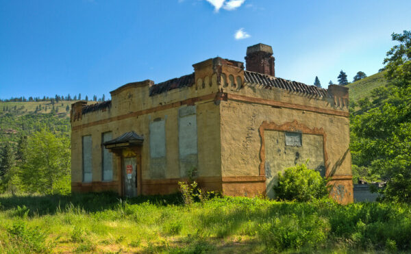
Several miles north of the town of Klickitat, carbonated mineral water bubbles to the earth’s surface through mysterious concrete pillars. You can identify the site by a strange, old stucco building on the east side of the river. The Klickitat Indians used the water from these springs for healing and sweat lodge ceremonies. In 1902 a summer bathhouse and resort was built here that soon failed. In 1908 a soda bottling plant was built with drinks like “Klickitat Mineral Water”, “Klickitat Pop” and “Mineral Ale”. But the business failed during the Great Depression. [Kiosk Wahkiacus trailhead.]

Ride Details

When We Like to Ride This

Jan
Feb
Mar
Apr
May
Jun
Jul
Aug
Sep
Oct
Nov
Dec
Not Rideable
Possibly Rideable
Rideable

Mid-spring thru early summer when the flowers are in bloom, and the rivers and creeks are running full. The Swale Canyon section is usually closed mid-June through October due to fire danger.

Terrain & Riding

The first 28 miles of the route are along the Klickitat – Swale Trail, a non-motorized multiple-use trail that follows an old railroad corridor that once linked the towns of Lyle and Goldendale. The gently graded trail starts in the town of Lyle, Washington, at the confluence of the Klickitat and Columbia Rivers, follows the nationally designated Wild and Scenic Klickitat River 13 miles through oaks and pines(Micro-video) to the old mill town of Klickitat, and then after a few paved miles, turns up Swale Creek at the Wahkiacus trailhead into the remote and beautiful Swale Canyon,(Micro-video) ending in the high, open ranch country of the Goldendale Plateau.

The trail is unpaved, with a packed fine gravel surface for the first 2 miles from Lyle to the Fisher Hill Trestle.(Micro-video) The rest is primitive, with dirt and larger gravel.(Micro-video)

The next 15 miles are along the Centerville Highway, a quiet country road. The first 5 miles undulate and climb an additional 500 feet. At mile 33, the route turns downhill with some undulations at first, but by mile 38.3, it is straight downhill — a 5% average grade for 5 miles.(Micro-video)

At the sweeping s-curve at mile 42, there is a small pull-out that is worth the stop. If you look up the canyon, you may get a glimpse of slackliners tightrope walking high above the river on a fine thread of rope. And, looking to the south, there is a majestic view of the confluence of the Klickitat and Columbia Rivers is backdropped by Mt Hood.

The Start

Lat / Long: 45.696619, -121.290136

Klickitat trailhead in Lyle, WA. Flush toilets, water.

Food & Water

  • ~ Mile 13: The town of Klickitat
Notes & Options

Route Notes

  1. Recommend a red blinky light for the Centerville Highway section.

  2. Personally, we recommend 50+ mm tires due to gnarly railroad grade gravel. But … we have heard of people doing it on 40 mm also.

  3. Please note that most of the land adjacent to the trail is private, and it is important to respect private property by staying on the trail. Adjacent landowners have poultry and livestock, and there is open-range grazing of cattle and sheep, especially in the section from the Fisher Hill Trestle to Pitt and in the Harms Rd.

Route Options

Alternative – Klickitat Gravel

This alternate route avoids all sections of the Klickitat Trail, following gravel roads instead. It covers 47 miles with 4,900 feet of elevation gain (a lot more gain than the Klickitat Trail version) and is rideable throughout the summer and much of the rest of the year.
Map: Klickitat Gravel
GPX File: Download

Comments

Have you ridden this route? Got a question? Join the discussion!

Get Involved!

The highlight of this route is the Klickitat Trail. If you’re looking for a way to give back (time, talent, or money), and we hope you are, take a look at the Klickitat Trail Conservancy.

Ridden and Reviewed by:

KevinE

KevinE / Team Dirty Freehub

He should have “Never Stop Exploring” tattooed on his chest! He loves adventures on bikes and is a Co-Founder of Dirty Freehub.

LindaE (aka Gravel Girl)

LindaE (aka Gravel Girl) / Team Dirty Freehub

She loves a good day of gravel, like most people like a good book. She’s always amused by the outdoors and the wild adventures. Gravel Girl is a Co-Founder of Dirty Freehub.

Explore Similar Routes:

Trains

Sign Up for the Dirty Freehub Newsletter

info@DirtyFreehub.org
Terms of Service Privacy EEO Policy Our Values
Dirty Freehub is 501(c)3 non-profit organization.
©2025 Dirty Freehub :: All Rights Reserved :: Website Design
Cleantalk Pixel

We Need Your Support!

Dirty Freehub is a 501(c)3 nonprofit funded by generous donations from riders like you!

  • $25 Keeps the lights on (web hosting, technology tools, insurance, etc.)
  • $50 Keeps lights on + up to date route conditions
  • $100 Continued route development
  • $200 Fully documented route guide
  • $200+ Gravel Girl giggle of gratitude

Donate Today