Deadman Willis


Caution! We do not provide turn-by-turn directions in our GPX files. Those are auto-generated by your bike computer and are usually less than 70% accurate. Learn more.
For help loading a GPX file onto your bike computer, go here.
DownloadHighlights & Remarkable Spots
~ Miles 0 to 4.5, Wahkiacus Hill / Paved
After a few hundred yards on the flats, the route starts out with a bang! Wahkiacus (Walk – e – ah – cus) Hill. It climbs 1000 feet in 2.5 miles with grades at 8 to 10%; luckily, it is paved!
~ Miles 4.5 to 16, The Timberlands / Gravel
The next set of miles are through actively managed timberlands. Some of it has been recently logged; some of it is new growth forest. The upside is that you get great views west and of Mt. Adams.
The terrain is mostly undulating, and the road surface varies widely — hard-packed, to pea gravel, to course and chunky, to sandy, to moderate washboard. This sector is the least rewarding of the ride – after this, it is dynamite good!
~ Miles 16 to 27.5, Deadman Willis Sector / Gravel & Dirt Double-Track
This is the crux sector of the day! The riding is mostly primitive double-track road that can be rocky, littered with pine cones, grassy, and a bit overgrown. The terrain is much different than that before, mostly woodlands with oak and pine with little evidence of recent logging activity. This sector is not fast going, and you must keep your Happy Face on! If you like rugged, remote, and scenic … you will love it.
Miles 16 to 23 are along Dead Canyon, to the rider’s right. At mile 23.5, you come to a small red out-building. If you go to the plateau’s edge and look down, you can see one of the Glenwood Valley timber mills. You will ride by that mill at mile 37.5.
From here, the red out-building, you still have about 4 miles of rugged until you intersect a good gravel road and head downhill.
~ Miles 27.5 to 30.5, Glenwood Descent / Gravel
This is a short sector but a very welcome sector after the ruggedness of the Deadman Willis sector. You get good gravel with a great view of Mt. Adams and a Cadillac gravel descent off the ridge.
~ Miles 30.5 to 57, Glenwood-Goldendale Highway / Paved
As much as we don’t like the word “highway” to describe the road being ridden, this is a great road for riding. It has little traffic, big views, a European-style road climb, and a kick-in-the-butt descent.
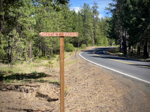
After making the right-hand turn onto the highway at mile 30.7, in a short distance, look left for a handmade wooden sign to Outlook Falls. Go! This is worth the detour and a bit of exploring. But, be warned, the trails are steep, and bike shoes make the walk even more treacherous. (If you make it all the way down to the base of the falls, please send us your GPS track.)
After leaving Outlook Falls, there is a second pullout to the left marked “viewpoint”. This is also worth the excursion and will give you views of the protected Klickitat Canyon.
“I always tell people Klickitat Canyon is the most beautiful part of Washington that they’ve never been to”, said Ulrich (the Columbia Land Trust’s conservation lead for the East Cascades and Columbia Plateau). “It’s a region characterized by its rugged remoteness and its gorgeous galleries of basalt canyons.”
The canyon’s unique transitional landscape offers a vital wildlife migration corridor, connecting oak-pine woodlands and grasslands to subalpine forests and meadows. The area is a wildlife haven for black bears, black-tailed deer, elk, sandhill cranes, owls, hawks, and elusive golden eagles. [Columbia Land Trust]
At mile 33.3, make a cowboy exit from the highway onto the old railway grade road just to the right. This road was used to bring uncut logs to the Glenwood Valley timber mill, ahead in 4 miles. We liked the history and experience of riding this old road.
At the mill, go back onto the highway; the road leading straight is a dead end and no-go!
Note that this is the same mill you saw high above at the little red house at mile 23.5. We don’t exactly know the connection between the two, and if you happen to know, please send us a note.
From here on, the riding is all on the highway. Drop and cross the Klickitat river (need to cool off, go for a quick swim!) and then begin the moderate but sustained Stitson climb to the top of the Columbia Plateau. This climb feels almost European – twisty roads with guard rails, open views down into the valley, little traffic, etc.
From the summit, ride the flats of the plateau for 6 miles and then finish with an exhilarating twisty descent on a nearly one-lane road back down to the Klickitat River. It’s only an 800-foot drop, but it averages 6.5%.
For the last 3.5 miles, spin on the flats along the Klickitat River and reminisce about a great day!
Credits & Acknowledgements
By Kevin English and Linda English of Team Dirty Freehub.
When We Like to Ride This
This route “will go” most of the year. The peak elevation is 3000 ft. We particularly like this route in the spring when the flowers are in bloom and the river is running fast. It is also a good option for when the winds are gusting in the Columbia Gorge as it is mostly protected.
Also, early in the season when the Gifford Pinchot National Forest routes are still covered in snow.
The Start
Swale Canyon Trailhead. Pit toilets.
Food & Water
- None.
Route Notes
Recommend a red blinky light for the Glenwood-Goldendale Highway section.
Route Options
To eliminate the demanding double-track of the Deadman Willis sector, stay left at mile 20 on the Spur 27 road. This will eliminate some of the best scenery but will make for a better bunch ride. RideWithGPS: Deadman Willis Spur 27 Option
Get Involved!
 The Klickitat Canyon section of the route (miles 32 to 42) is a very special and scenic area. Recently, the Columbia Land Trust completed an 11,000 acre acquisition of lands within the canyon. We encourage you to learn more about their work and contribute back with time, talent or money.
Also, this route would not be possible without the the recreation access granted by Hancock Forest Management. We also encourage you to call Hancock Forest Management (503-838-1610) expressing your support for recreational land use by bicycles. (Use the term bicycles not bikes, bikes can be mistaken to mean motor bike.)
Videos
The Ride! Deadman Willis
A quick 2-minute video of what to expect on your ride!

 Behind every route is scouting, mapping, storytelling, and a whole lot of pedal power.
Have you ridden this route? Got a question? Join the discussion!