Billy Lyle


Caution! We do not provide turn-by-turn directions in our GPX files. Those are auto-generated by your bike computer and are usually less than 70% accurate. Learn more.
For help loading a GPX file onto your bike computer, go here.
DownloadHighlights & Remarkable Spots
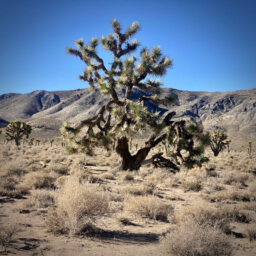
Lee Flat Joshua Tree Forest / Start to Mile 4
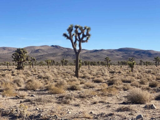
The finest stands of tree-sized yuccas in the park grow in this mountain-rimmed valley. The Joshua tree is a species of the yucca, one representative of the lilly family, which includes onions, asparagus, tulips, and the common lilly.
Mormon pioneers, seeing the outstretched limbs of these bizarre plants, thought of the prophet Joshua pointing the way to the Promised Land. [National Park kiosk]
Panamint Valley Viewpoint / ~ Mile 7.7
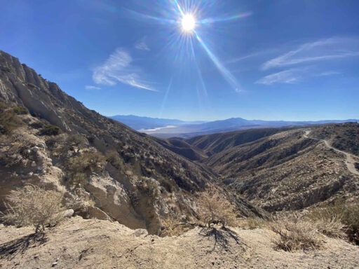
The Panamint Valley is a north-south, 65 mile-long and 10 mile-wide, basin formed between the Argus and Slate ranges along the west, and the Panamint Range on the eastern side.
“The Valley is part of the traditional homelands of the Newe (Western Shoshone) and Northern Paiute Tribes. Local tribes, such as the Timbisha Shoshone Tribe of Death Valley, continue to value the area and engage in traditional uses there.
The Valley is home to many species, including the iconic desert bighorn sheep, western snowy plover (a California Department of Fish and Wildlife Species of Special Concern) and rare plants such as the polished blazing star and Death Valley sandpaper-plant. The area contains unique desert wetland communities including mesquite bosques and freshwater and saltwater marshes. Endemic fairy shrimp occur in Panamint Lake, which is the remains of a Pleistocene lake that was originally 700 feet deep. The Lake encompasses two major springs, Warm Sulphur Springs and Post Office Springs.” [California Wilderness Coalition]
Hunter’s Cabin / ~ Mile 13.5
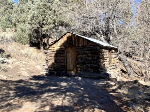
“The ranch area as far as can be ascertained was primarily used for grazing of the mules and horses that Hunter used in his pack trains or supplied to the army. [10] It is doubtful that it was ever occupied for any extended period of time, but was instead used mostly as a line camp.” For more on Willaim Lyle Hunter, give a read to this Historical Resource Study.
Picnic Rock / Mile 17
This is a cool stopping point on the return, looking towards the Palisades in the Northwest. “The peaks in the group are particularly steep, rugged peaks and contain the finest alpine climbing in California.”[Wikipedia]
When We Like to Ride This
October to April, when the temperatures are reasonable. Note, the route starts at 5300 feet and climbs to 7200 feet. Be aware that temps could be 15 to 35 degrees cooler than Furnace Creek. Temperatures drop 3 to 5°F (2 to 3°C) with every thousand vertical feet gained(approx. 300m).
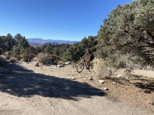
Terrain & Riding
Hilly and undulating riding through 3 distinct zones ecological zones. The first is the Joshua Tree forest, then a transition zone with scrub pines and Juniper, and then a higher elevation alpine zone in the Cottonwood Mountains with bigger trees, rocky boulders, and a more green landscape.
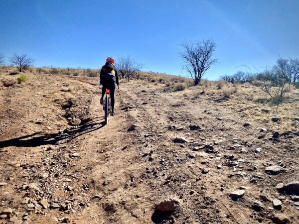
The riding is mostly open and exposed, through foothills and mountainous terrain, with some fabulous distant views of mountain ranges and the Panamint Valley. The grades are mostly moderate at 4 to 6%, but there are several shorter steeper pitches at 10 to 15%.
The roads are a mix of wide gravel roads (in the start) and single-lane dirt roads (the majority of the ride) that challenge you with embedded rock, baby heads, and some wash sand, more like a cheap box wine than champagne gravel. The rough feel is not that noticeable on the climb out, but it is more evident on the return. And … don’t expect the return to be all downhill, it is not!
The Start
Dirt pull-out at the intersection of Saline Valley Road and White Mountain Tack Road. Approximately a 12-mile drive north from Highway 190 on a dirt / broken pavement road.
Food & Water
- None.
Route Notes
We recommend checking the National Park Service’s road conditions page before your ride. Many roads in Death Valley National Park have been affected by weather and flooding in recent years.
Death Valley is classic Southwest desert riding with more of a jeep road feel than a classic gravel road; it can vary from hard-pack with embedded rock to loose and course to soft wash sand and washboard. The surfaces are ever changing based on based on maintenance, rains, and time of year. Thus, error on the side of too much tire, rather than not enough. We Recommend 50 mm (2.1”) tires or larger and an adventure gravel bike versus a more traditional all road gravel bike.
For a bit more information see our post, Riding in the Desert Southwest.
We rode this on a Salsa Cutthroat adventure bike with Rene Herse Fleecer Ridge 2.2″ tires with CushCore inserts.
After mile 17 we dropped air pressure by 3 to 5 psi for comfort.
Route Options
Start at the intersection of Highway 190 and Saline Valley Road and ride in.
Lat / Long: 36.364246, -117.626135
Love Where You Ride! Learn More
“The Joshua tree, has and will continue to feel the stress of hotter temperatures and drought conditions. By 2099 under the highest emissions scenario forecasted, the average annual temperature inside the park could increase by 8℉ (5℃). Research suggests that under these conditions, it could eliminate nearly all suitable habitats for Joshua trees in the park and reduce habitat in the Southwest by 90 percent. Even with lower emission scenarios, nearly 80 percent of suitable habitat in Joshua Tree could be lost.
The good news is there is still time to make a difference. We can prevent the most catastrophic consequences if we choose to drastically reduce our greenhouse gas emissions. It will require bold changes to how humans live on planet earth. This can be accomplished in many ways:
- Convert to renewable energy sources (wind and solar) to power our homes and industries
- Use more fuel-efficient transportation and electric vehicles
- Utilize more energy-efficient appliances and heating/cooling systems
- Reduce consumption, reuse goods, and recycle
- Buy locally sourced food, reduce meat consumption, and cut down on food waste
- Unite the global community in the effort to combat climate change
Will you help be part of the change?”[National Park Service]
Videos
The Ride! Billy Lyle
A quick 2-minute video of what to expect on your ride!
Be Informed!
Ridden and Reviewed by:


 Behind every route is scouting, mapping, storytelling, and a whole lot of pedal power.
Have you ridden this route? Got a question? Join the discussion!