Wolf & Bear


Caution! We do not provide turn-by-turn directions in our GPX files. Those are auto-generated by your bike computer and are usually less than 70% accurate. Learn more.
For help loading a GPX file onto your bike computer, go here.
DownloadWhen We Like to Ride This
Mid spring through mid summer when the creeks are flowing and the flowers are in bloom.
Terrain & Riding
The ride starts at in the town of Paulina (population ~ 150), a ranching community 50 miles removed from Prineville. The first 12 miles are glorious pavement rolling up and down. The traffic is light, mostly ranchers and farm hands. Most people wave. The long sweeping ridge directly in front of you is Wolf Mountain.
At mile 11 make a soft left onto NF 42, a single lane paved road. In a mile or so, at the junction with NF 3810 and just past Salter’s cabin, the road becomes gravel. The next 9 miles climb 1600 feet. The climbing is quite moderate, the upper section of the climb is the steepest averaging 5%. Near the summit, you are in the southern shadow of Bear Mountain.
Salter’s cabin was originally a house located at the mill site in Paulina. In the 1930’s the building was moved to its current location … a horse pasture within the Ochoco National forest. The salter was a man employed each year to maintain fences, salt cattle, and change pastures on the stock animals.
Just after mile 21, the terrain opens up and the riding becomes more rolling in nature, with a downward trend. You will pass by grassy fields, small meadows, Little Summit Prairie and a grove of Aspen trees. Then back into the Ponderosa forest.
At mile 33 (“Cruelty Corner”) you’ll think you’re home free. But, you’re not! Pavement lies in front of you, but you go left. Up a pitch. Then down. The forest changes over to grasslands with a few scattered trees, but the road is still good. That is, until mile 37.5. (The next 5 miles are the crux of the ride.) The “good” road goes left, the route goes straight. It is rugged and rocky. But it also offers up some big views. The large butte in the distance is Maupin Butte. (No, it is not close to the town of Maupin.)
In several miles the rock gives way to loamy soil underneath big trees. The road can be deeply rutted. On a wet day, this 2 mile segment could be a muddy mess. There is also a stream crossing or two on this segment. Maybe ankle deep. Rideable.
By weight, the mineral composition of loam soil is about a 40–40–20% concentration of sand–silt–clay, respectively. These proportions can vary to a degree, however, and result in different types of loam soils: sandy loam, silty loam, clay loam, sandy clay loam, silty clay loam, and loam.
At mile 39.4 you leave the National Forest. The road is public access, but there may be signs posted with private property warnings. You are on a public right of way. At mile 42, the Paulina Valley comes into view. Through the middle of the valley runs Paulina creek. This is the 6 mile “Easy Street” segment. The gravel is flat and fast!
At mile 48 comes the Sabre Ridge bump. A 1 mile pitch gaining a couple of hundred feet. Near the summit it is the steepest. Then comes the fun descent back into Paulina. This will put a smile on your face and have you wishing all rides finished this way.
The Start
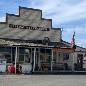
Dirt pullout at the intersection of Highway 380 and Paulina Valley road. No services. However, just across the street is the Paulina General store.
Food & Water
- None
Route Notes
We recommend a red blinky light with rear looking radar detector (i.e. Garmin Varia)


 Behind every route is scouting, mapping, storytelling, and a whole lot of pedal power.
Have you ridden this route? Got a question? Join the discussion!