Westside Tour


Caution! We do not provide turn-by-turn directions in our GPX files. Those are auto-generated by your bike computer and are usually less than 70% accurate. Learn more.
For help loading a GPX file onto your bike computer, go here.
DownloadHighlights & Remarkable Spots
Drake Park / ~ The Start
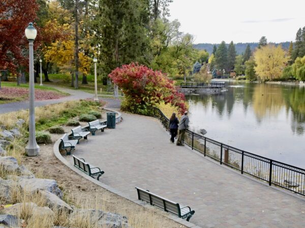
In 1910, Alexander M. Drake purchased the land that currently encompasses the Drake Park Neighborhood Historic District, with plans to subdivide and develop. After disposing of his vast assets in Central Oregon and leaving town, the land that is now Drake Park sat idle for 10 years, waiting for future endeavors (potentially as another lumber mill).
In 1921, May Arnold and the Women’s Civic Improvement League initiated a campaign to acquire the riverfront property, ultimately collecting 1,500 signatures and a $21,000 bond to finance the city’s purchase of the land. The bond measure passed and the City of Bend purchased the 11-acre riverfront property which would later become known as Drake Park. [Deschutes History]
Pioneer Park / ~mile 0.7
On your left is Pioneer Park. In the 1850s immigrant trains of pioneers used this spot to ford the Deschutes River on their trek to western Oregon. This spot was known as Farewell Bend and it is from this origin that the city of Bend derived its name. [on-site kiosk]
Buried Irrigation Canal / ~ miles 2-5

Under this section of trail is an irrigation diversion for the Tumalo Irrigation District. Prior to the early 2000s, this was an open irrigation canal. Piping projects like this significantly conserve water lost due to seepage and evaporation compared to an open canal and also provide for greater recreational infrastructure. This was a collaborative project between the Tumalo Irrigation District and Bend Parks and Rec. [on-site kiosk]
Milky Way / ~ mile 7
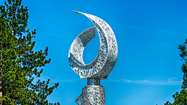
The Milky Way is a stainless steel sculpture that is located at Shevlin Park Road and Mt Washington Drive. Check out this podcast to hear Pete Stein interview Devin Field, the artist behind this fun piece. Listen in as we learn about how the art was commissioned and then how it was designed and built. Also, The Milky Way is lit by solar power; learn about why this is an important part of the art and the challenges of keeping it lit.
Shevlin Park / ~ mile 9
Long before European Americans arrived in Central Oregon, the land that is now known as Shevlin Park was of great significance to the Warm Springs, Burns Paiute, and Klamath tribes. Then, in the mid-1800’s, European-American fur trappers looking for beaver visited the region. The area thus played host to early explorer camps, logging mills, railroads, fish hatcheries, and more throughout its history. In December of 1920, Shevlin Park was generously gifted to the City of Bend. The official transfer of ownership took place in January 1921. At its inception, the park encompassed 350 acres, but it has since grown to approximately 1,000 acres. [Bend Park & Recreation]
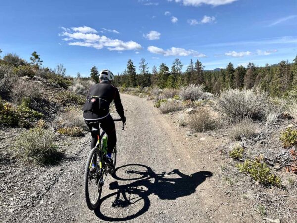
Phil's Trails / ~ mile 14
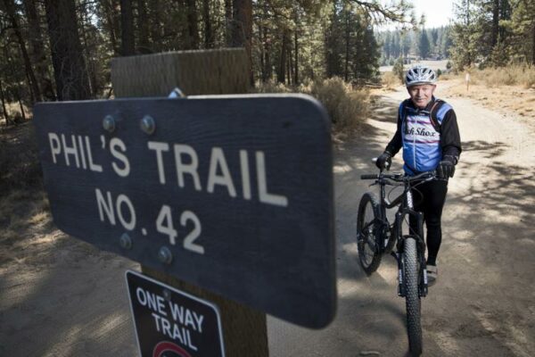
Phil’s Trails is one of the most well-known mountain biking trail networks in the area. The trail system is named after Phil Meglasson, a local mountain biking enthusiast who, along with other riders, helped to develop the trail network. Phil’s Trails offers numerous interconnected loops and trails, making it possible to customize your ride depending on your skill level and desired distance. In addition to mountain biking, the trails are also used for hiking and trail running, particularly during the warmer months. [Travel Oregon]
Old Haul Road / ~ miles 19.5 to 21.5 to
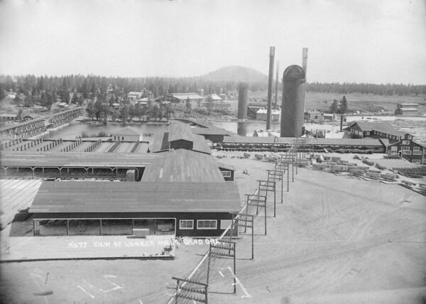
These miles follow along the old haul road, a historic railroad logging route that was used to transport logged trees to the Brooks-Scanlon and Shevlin-Hixon mills, located along the Deschutes River near the Old Mill shopping area today. The rail lines were used in place of the river on this segment due to the number of cascades and falls. Picture – Shevlin-Hixon Mill on the west bank of the river. [Old Mill District]
Sound Garden Art / ~ mile 22.5
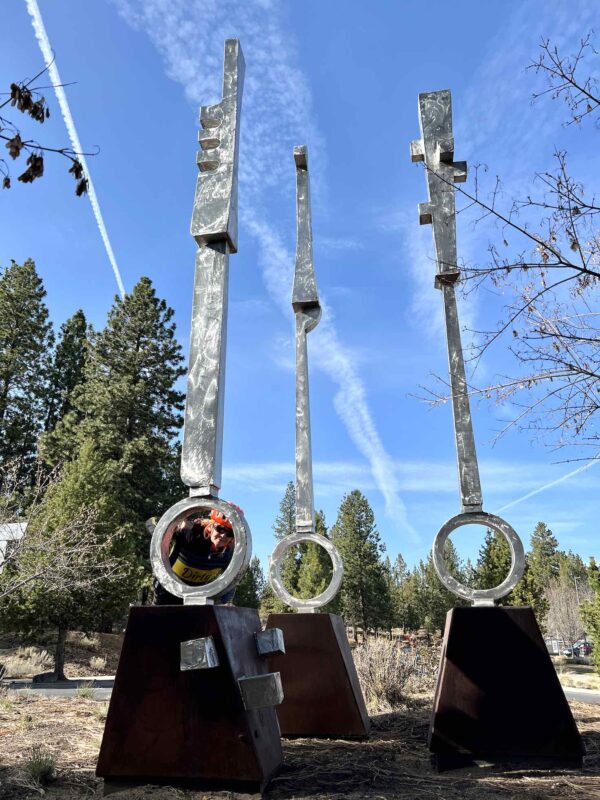
“Sound Garden was made by award-winning Portland artist Lee Kelly in 2010. This piece leveraged his 50+ years of sculpting experience to create Sound Garden, a stainless steel representation of organic musical notes rising above native plants and trees.” [Visit Bend]
Centennial Logger & Centennial Planter / ~ mile 23
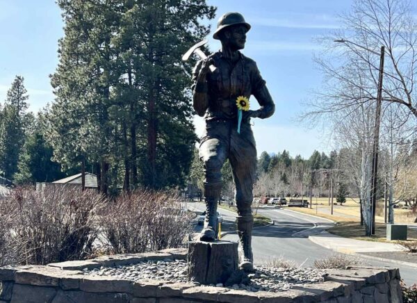
Residing in the two roundabouts on Reed Market Road west of the Bill Healy Memorial Bridge (across the river from the bike path), the Centennial Planter and Centennial Logger bronze statues were created by Bend-based artist Jerry Werner to commemorate the City of Bend’s 100th anniversary, and represent the cycle of life. [Visit Bend]
Dragon Mural / ~ mile 23.5
“Yuya Negishi is a Japanese visual artist based in Minneapolis, Minnesota. His work combines his extensive background in the classical Japanese techniques of calligraphy and SUMI with Japanese pop culture images such as koi, dragons and Buddha’s. Yuya approaches his work in the spirit of play often exploring new ideas and mediums. His newest graffiti-style art mural, a Dragon, can we viewed from the Deschutes River trail walking path just behind The Gap — or check it out when you ride by!” [Old Mill District]
Spring Bird & Flowers Mural / ~ mile 24
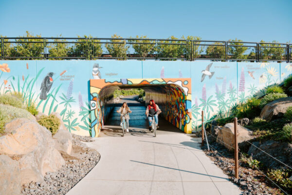
As you ride by the tunnel under the Colorado Bridge, take a moment to check out the Spring Bird and Flowers mural, painted by artist Sandy Klein. You’ll see numerous birds and flowers! Including the kingfisher, red winged blackbird, osprey, tree swallow, and more. In case your ornithology is a bit rusty, there are labels next to each bird to help you out. [Old Mill District]
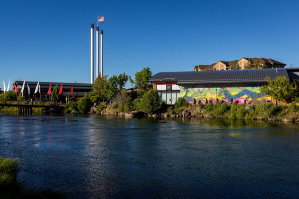
Old Mill District / ~ mile 23.5
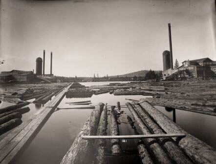
In the early 1900s, the Brooks-Scanlon Lumber Company established a large sawmill in this area, taking advantage of the abundant timber resources of Central Oregon. At their peak, the Brooks-Scanlon and Shevlin-Hixon operations were two of the largest pine sawmills in the world, running around the clock and employing more than 2,000 workers each. The mills operated for several decades, but eventually closed in the 1990s as the demand for lumber declined. The site was abandoned for several years, but in the early 2000s, a redevelopment plan was initiated to transform the area into a mixed-use shopping, dining, and entertainment district. The old brick powerhouse buildings and their three towering smokestacks still stand, silently testifying to the district’s colorful past. [Old Mill District].
For more, check out the podcasts on the sidebar!
Miller's Landing Park / ~ mile 24

In 1877, the land that is now Miller’s Landing Park was claimed by Stephen Staats. Over the years, the park was used as a ranch, as well as the site of a hotel and one of Bend’s earliest post offices. In 1924, the land was purchased by Harry Miller, the owner of Miller Lumber Company. In 2010, The Trust for Public Land (TPL) spearheaded a community-wide fundraising effort to purchase the land from its then-owners, the Miller family and Brooks Resources Corporation, with the goal of preserving the land as a community park for all to enjoy in perpetuity. TPL led a campaign to raise $700,000 to assist the Bend Parks and Recreation District in acquiring the land that is now Miller’s Landing Park. [Bend Parks and Recreation]
When We Like to Ride This
This is a go to route for us Bend locals. It goes most of the year, except when we there is snow in town. We like this route outside of tourist season. If done during the summer, an early start is recommended (prior to 8 am).
And if the weather is touch and go, this is a perfect route. It is really easy to bail out and be back to town in a flash.
Terrain & Riding
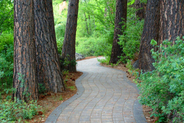
The route is fun, close to town, and relatively flat. It is a mix of urban and national forest paths, gravel and paved roads, and a “smidge” of single-track. There are scenic river and mountain views.
Expect to encounter others on the trails, and remember to be courteous and share the trail!
Be ready to test your navigation skills. There are a number of tricky turns that are easy to miss, so have your navigation device zoomed into super detail!
The Start
Drake park near the historic green “wagon wheel”.
Food & Water
- ~ mile 0: downtown Bend.
- ~ mile 20.5: the cafe at the Loge Bend.
- ~ mile 24: the Old Mill.
Route Notes
We recommend a red blinky light with rear looking radar detector (i.e. Garmin Varia).
Many of the trails along the route are multi-use. Walkers, those with little kids, etc., have priority. Be courteous. Stop and put a foot down if need be. #ShareTheTrail
The “High-Wheel” logging skidder, at the start, is currently undergoing refurbishment and is not in place. As of spring 2025.
Love Where You Ride! Learn More
Following the creation of the initial roundabouts in the late 1990’s, the question arose as to what to do with the vast, unoccupied space at their centers. That’s where Art in Public Places, a Bend-based nonprofit organization funded by the Bend Foundation, stepped in. Since 1973, this organization has generously donated public art installations throughout the city, including in the center of the roundabouts. We have them to thank for the “stimulating, unexpected, and uplifting way to experience Bend.” [AIPP].
Videos
The Ride! Westside Tour
A quick 2-minute video of what to expect on your ride!
Podcasts
Roundabouts in Bend (A short history)
In this podcast, we talk with Mike Hollern, the Chairman of the Board for Brooks Resources, about the early days of roundabouts in the city of Bend. Learn about the first roundabout, some of the challenges in building [...]
History of the Old Mill
Learn about the history of the Old Mill, how it influenced the name of the town of Bend, Oregon and what it looked and felt like when the mills were operating. Joining us is Kelly Cannon Miller, the Executive Director of the Deschutes Historical Museum and Vanessa Ivey the Manager of the [...]
Logging in the Old Mill: Local Cyclist Tells the Story
Bend, now a town of outdoor enthusiasts, microbreweries, and technology, used to be the center of timber production. The Old Mill District was the heart of this activity, with two active mills, one on the east bank of the river and one on the west bank. In the 1950s, over 50 rail cars per [...]
Keep it Local! Learn More

Ridden and Reviewed by:


 Behind every route is scouting, mapping, storytelling, and a whole lot of pedal power.
Have you ridden this route? Got a question? Join the discussion!