Tygh My Shoes
Closed to public access from Dec 1–Mar 31 due to wildlife winter-range protection.


Caution! We do not provide turn-by-turn directions in our GPX files. Those are auto-generated by your bike computer and are usually less than 70% accurate. Learn more.
For help loading a GPX file onto your bike computer, go here.
DownloadHighlights & Remarkable Spots
Larch Creek Fire / ~ Mile 0.5 to 7.5
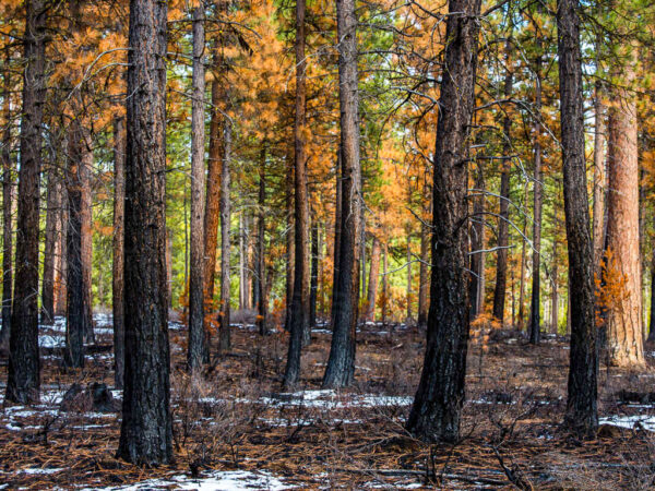
In this sector, you will see evidence of the 2024 Larch Creek Fire. Look for the low-intensity burn areas, which you can identify by: most large trees remaining standing with green, intact crowns, and only a few showing light browning at the top. This pattern—trees alive, upright, and with largely unscorched canopies—is the clearest sign of a cool, healthy fire.
Low-intensity fires play an essential role in forest health. They reduce built-up fuels, preventing future high-severity wildfires, and they open the canopy, allowing more sunlight to reach the forest floor. This renewed light and space stimulates the growth of native grasses, flowers, and shrubs, restoring the natural, open structure of ponderosa forests.
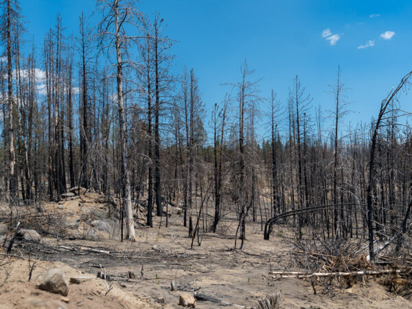
These fires also create a burst of opportunity for wildlife. New growth provides nutrient-rich forage for deer and elk, the thinned understory offers easier movement corridors, and lightly burned trees create snags for cavity-nesting birds such as woodpeckers, bluebirds, and owls. Increased insect activity and improved soil nutrients further support a thriving post-fire ecosystem.
At left, we show a low-intensity burn, and below that, a high-intensity burn. Click on images for expanded views.
Tygh Valley Pioneer Cemetery / ~ Mile 1
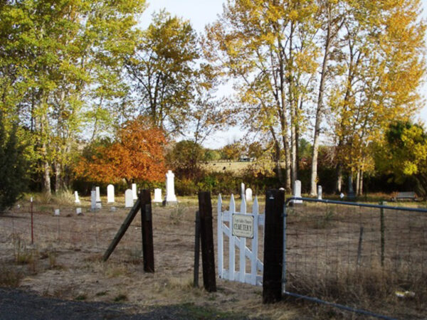
Pioneer cemeteries like this one serve as a record/marker of Oregon’s early settlement. Anchored to frontier communities and aligned with wagon roads and trade routes, they trace the spread of homesteads across Wasco County. Weathered markers record 19th-century families who built farms and ranches here, revealing patterns of migration, land ownership, and kinship. Nearby sites like the Tygh Valley IOOF Cemetery mirror this landscape of small, community-based burial grounds that quietly map Oregon’s settlement history.
Oregon White Oak Trees / ~ Miles 2 to 10
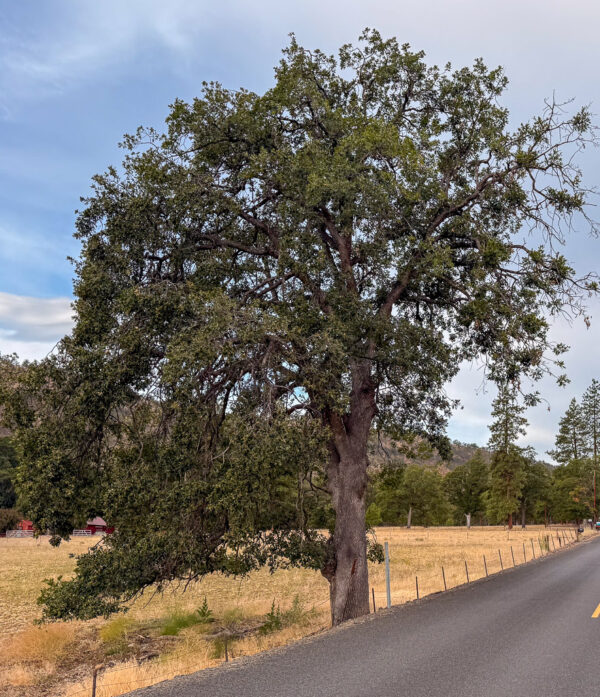
Here you will see the Oregon white oak. At one time, oak savannas covered these hillsides. Today, less than 10% of its historic range remains because of several overlapping human and ecological changes:
Fire suppression: Historically, periodic wildfires kept the savanna open by clearing conifer seedlings and dense shrubs. When settlers began suppressing fires in the late 1800s, Douglas-fir and other trees moved in, shading out the oaks.
Agricultural conversion: Many oak savannas occupied gentle slopes and fertile soils—the same areas ideal for wheat, orchards, and pasture. Clearing for farms drastically reduced oak habitat across Wasco County and the Columbia Plateau.
Competition from invasive species: Grasses like cheatgrass and medusahead replaced native understory plants, altering soil chemistry and fire behavior, further hindering oak regeneration.
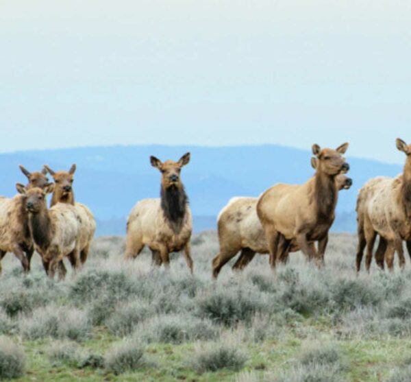
White River Wildlife Area / ~ Miles 4 to 10
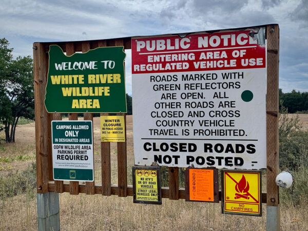
Established in 1953, this 30,760-acre wildlife area was created to protect winter range for black-tailed deer and Rocky Mountain elk. It’s a mix of oak, pine, and fir forests, along with meadows and small creeks. The Wildlife Area helps minimize damage deer and elk might otherwise cause to nearby private agricultural lands — a practical benefit that balances wildlife conservation with human land use. The varied habitat supports one of northern Oregon’s largest wild turkey populations.
Old Apple Tree / ~ Mile 4.2
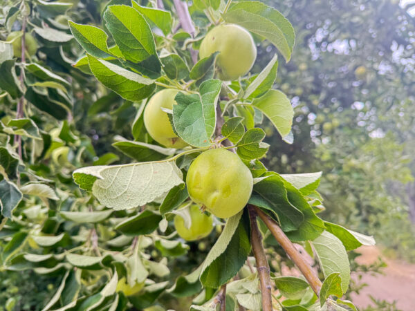
Just past the creek crossing, a lone apple tree stands beside the road, a sign that this area may have once held a small homestead. Old orchards often survive long after buildings disappear. The open field nearby also suggests past clearing. Easy access to water and the presence of an old road (this one) further support the idea that a family once lived and worked here.
Up the road by another mile or so, you will see the remaining remnants of a chimney structure. Possibly another early homestead. (Mile 8.7 as ridden)
Friend School / ~ Mile 10.7
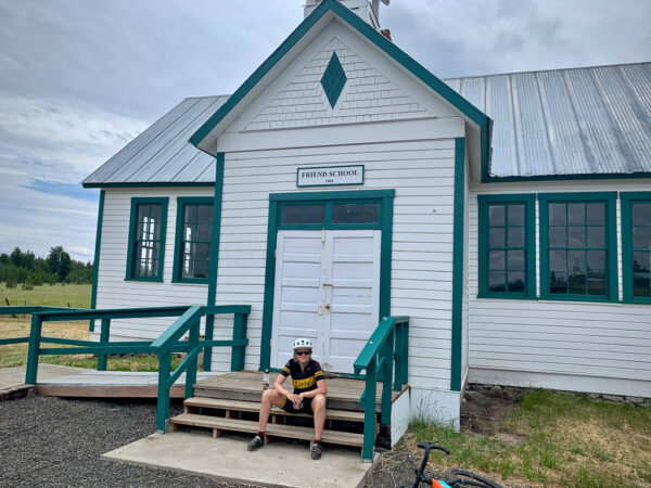
The Friend School is a small, historic one-room schoolhouse and one of the last remaining buildings from the old railroad and farming community of Friend. The town once served as the end of the Great Southern Railroad line, which connected The Dalles and Dufur to this remote farming district. When the railroad shut down in the 1930s, Friend declined to near-ghost-town status, and the schoolhouse remains one of the few tangible reminders of that era.
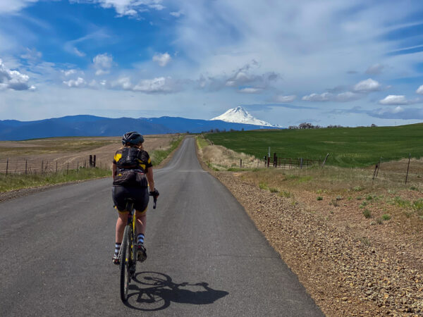
Mt Hood Viewpoint / ~ Mile 12
Folklore has it that long before these peaks were stone and snow, they were people.
Two brothers, proud and strong.
Wy’east, the fiery one—quick to laugh, but quicker to rise in anger.
Pahto, quieter, heavier in thought, but no less fierce.
And between them lived a maiden, Loowit, graceful as moonlight on still water.
Click through to read the rest of the tale (~ 1 to 2 minutes).
Badger Creek Wilderness / ~ Miles 16.5 to 21.5
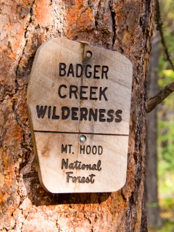
Badger Creek Wilderness spans 29,057 acres. Unlike wilderness areas that are strictly alpine or strictly dry-forest, Badger Creek covers a full east–west environmental gradient, ranging from subalpine ridges to dry pine-oak grasslands. This breadth of ecosystems within one protected area is uncommon, supporting plant and animal species adapted to very different conditions and preserving a corridor of varied habitats.
Additionally, Badger Creek safeguards old-growth and mature forests within a transitional landscape that was historically more susceptible to logging because of its accessibility and lower elevation. This context makes the wilderness especially significant from a conservation standpoint.
Tygh Valley Viewpoint / ~ Mile 17.2
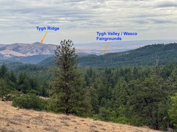
Around 1850, Tygh Valley became part of an alternate route to the main Oregon Trail corridor along the Columbia River. Instead of risking the dangerous river passage from The Dalles, some emigrant wagon trains turned south toward Tygh Valley, crossing Tygh Ridge and descending into the broad valley floor—near where the Wasco County Fairgrounds stand today. This overland route, known as the Tygh Valley Cutoff, offered a safer but rugged path that connected with the Barlow Road, the final stretch across the Cascades into the Willamette Valley. For many settlers, Tygh Valley marked the turning point between the perilous Columbia route and the promise of Oregon’s western farmlands.
Basalt Rock Cliff Bands / ~ Mile 28
Look for stair-stepped cliffs edging the hillsides—these are ancient basalt layers, frozen remains of one of Earth’s greatest lava floods. Between 17 and 14 million years ago, immense fissures in eastern Oregon erupted again and again, releasing molten rock that flowed hundreds of miles and stacked into sheets thousands of feet thick. As each layer cooled, it cracked into hexagonal columns, creating the striking formations you see today.
Erosion by the White River (and its tributaries like Tygh and Badger Creek) carved deep canyons through the hardened flows, revealing cross-sections of this immense geologic history.
These cliffs belong to the Columbia River Basalt Group—one of the largest continental lava events on the planet, rivaling those found in India’s Deccan Traps and Siberia’s flood-basalt fields.
When We Like to Ride This
Spring through fall. Summer can be hot! Early spring can have a significant stream crossing and could possibly be muddy. The section of the White River Wilderness area that the route goes through is closed December 1 to March 31st for black-tailed deer and Rocky Mountain elk migration.
Heart of summer, can get a bit dry and dusty on primitive road. In the spring time will have several wet stream crossings, 6 to 12 inches deep.
Terrain & Riding
We love the terrain on this route. It is a mix of farmlands and grasslands, oak savannah, Ponderosa forest, basalt cliffs and meandering streams.
The start is at the Wasco County Fairgrounds. It has parking, flush toilets and camping with hookups. Heading north and then east out of Tygh Valley, you come across small cattle farms with lovely, open grazing areas. Instead of cattle, we spotted lots of deer resting in the shade of the pine trees. Also, look carefully, and you will see a number of oak trees.
At mile 3.9 is where your adventure begins. There’s a tricky turn to your right. Yes, it is the smallest of the roads, and it appears to be someone’s driveway. The road is primitive and demanding for the next 6 miles. See the slide/picture deck for more information.
The road climbs through and out of a canyon, eventually leading to views of the river to your right. At mile 5.6, there is a path that leads down to the swimming hole. It is easy to miss … but if you see a large dirt “parking area” to your left, you have gone beyond the swimming hole trail. Also, at mile 6.4, there is a trail to the right to a hidden waterfall.
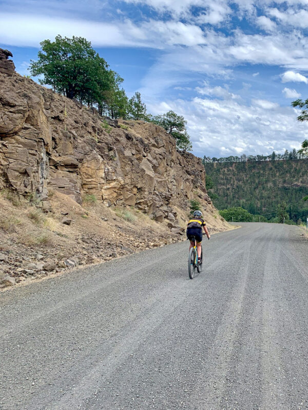
From here and beyond, it’s a zig-zag journey on rough gravel until you reach Friend. Sometimes you have open views, sometimes you are making your way through a smattering of trees, and sometimes it is tall grass all around you.
The historic Friend schoolhouse does not appear to be locked. We stepped inside to get more of the history and to place our fingers on the old piano, that was just ready for an impromptu concert.
Leaving the ghost town of Friend and heading west, you get a small dose of paved road followed by a wide and fast rolling gravel road. Soon, you make a left-hand turn onto a single-lane paved Forest Service road that hugs the eastern edge of the Badger Creek Wilderness area. For the first 6 miles, the road rolls up and down, with no net gain in elevation. At mile 20, the downward descent into Tygh Valley begins. Use caution on this sector. There are dips, cracks, and sections of broken pavement. For us, in the tighter turns, rocks and small boulders had washed down onto the road.
At mile 23, make a left onto the gravel road. For us, this section of gravel was moderately to heavily washboarded, but a smooth line could usually be found towards the road edges. Interestingly, and unexpectedly, the closer we got to Tygh Valley, the better the road conditions became. And to finish things off on a high note, you get some really scenic vista views near the end of the descent. When the pavement returns, it is just a few clicks back to the Fairgrounds.
At mile 26.9, you make a left onto a two-lane gravel road that can be washboarded. If you have suspension (squish!), turn it on! If your tires are over-inflated washboard like this can be brutal on the hands.
How to ride washboard downhill:
– Be discerning! Look for smooth lines and steer into them.
– Get your butt off the saddle
– Place your pedals at 3 and 9, dip your heels, and point your toes upwards
– Put your hands into the drops, use a loose group, and bend at the elbows. Do not over-grip!
– Do not brake (or try to brake in corners). Grab your brakes strongly before severely washboarded spots, not in the washboard.
The Start
Camping with hookups. Flush toilets and water. More information.
Food & Water
- None.
Route Notes
May prefer 50 mm tires for the wildlife refuge sector.
Love Where You Ride! Learn More
![]() Discover South Wasco — a place where community spirit is thriving, not just surviving. The South Wasco Alliance is at the heart of a grassroots movement that’s nurturing the region’s unique culture, natural beauty, and local grit. This is a community on the rise — scrappy, collaborative, and full of quiet momentum. It’s not about replacing what’s here, but about building on the rich foundation that already exists: honoring local voices, landscapes, and traditions while sparking sustainable economic growth.
Discover South Wasco — a place where community spirit is thriving, not just surviving. The South Wasco Alliance is at the heart of a grassroots movement that’s nurturing the region’s unique culture, natural beauty, and local grit. This is a community on the rise — scrappy, collaborative, and full of quiet momentum. It’s not about replacing what’s here, but about building on the rich foundation that already exists: honoring local voices, landscapes, and traditions while sparking sustainable economic growth.
Dirty Freehub riders, you know the value of places that feel real — unpolished, authentic, and still a bit undiscovered. South Wasco is that kind of place. When you roll through our gravel roads, you’re not just riding — you’re witnessing a region in motion. Help us carry the word, return often, and become part of the story we’re writing together.
Podcasts
All About Basalt with the Rock Doctor
You will find these rocky columnar cliffs in Eastern and Central Oregon, but what exactly happened to form these unique structures? In this podcast, we talk with our resident rock doctor, Dr. Kim Ely.
Be Informed!
Keep it Local! Learn More
Ridden and Reviewed by:


 Behind every route is scouting, mapping, storytelling, and a whole lot of pedal power.
Have you ridden this route? Got a question? Join the discussion!