Townie


Caution! We do not provide turn-by-turn directions in our GPX files. Those are auto-generated by your bike computer and are usually less than 70% accurate. Learn more.
For help loading a GPX file onto your bike computer, go here.
DownloadHighlights & Remarkable Spots
Greetings From Mural/ @ start
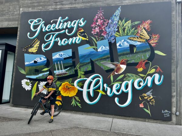
Bend’s “Greetings From” mural, covered in colorful wildflowers and butterflies, grassy plains, and snow-topped peaks, is part of the Central Mural Oregon Trail. Sponsored by Visit Central Oregon, similar murals can be found in towns big and small across the central part of The Beaver State. Painted by artists Katie Daisy and Karen Eland, the murals take inspiration from vintage postcards and predominantly feature natural elements — such as flowers and animals — that are unique to the region. The murals are painted on MDO panels and covered with a special varnish/sealer to protect them from the elements. [DF Connection podcast]
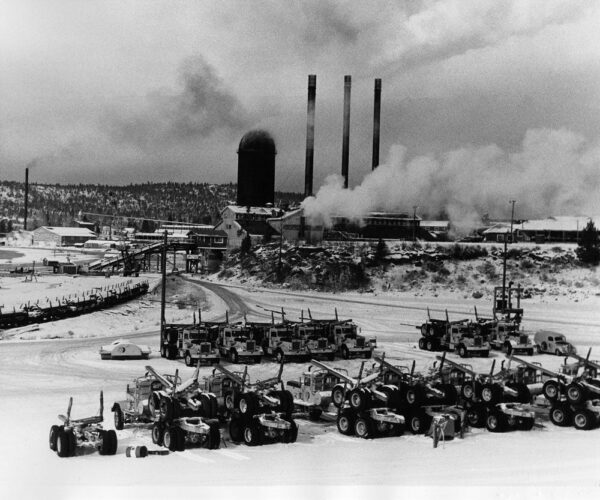
Logging History Kiosk / ~ Mile 0.5
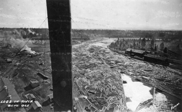
“This stretch of the Deschutes river was filled with logs waiting to be processed. To keep the log pond full, 80 to 95 rail cars carried harvested trees from the woods to town daily, unloading them into the river just below the present site of the Bill Healy bridge.” [On-site kiosk]
[Photo: OSU Special Collections & Archives]
Centennial Logger / ~ Mile 0.5
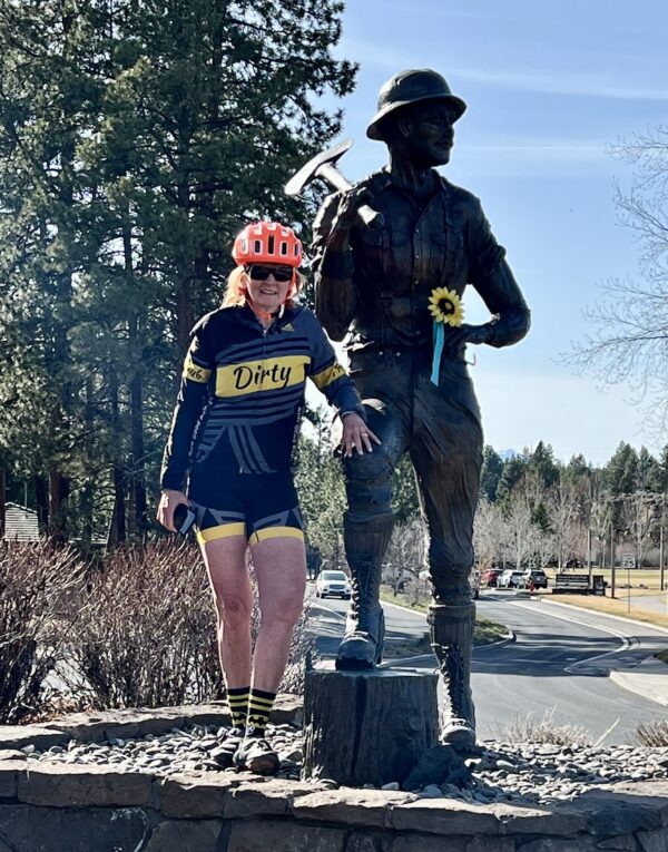
Centennial Logger, along with Centennial Planter, was created by long-time Central Oregon artist Jerry Werner to commemorate the City of Bend’s 100th anniversary. The sculpture is installed close to an old log deck along the Deschutes River as a tribute to the region’s deep roots in the logging industry. The two sculptures represent the cycle of life from birth to death. Werner begins his bronze pieces as clay sculptures, which allow him to better capture the smallest of details. [Visit Bend]
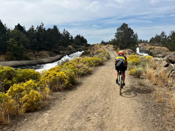
Central Oregon Canal / ~ Mile 2.5
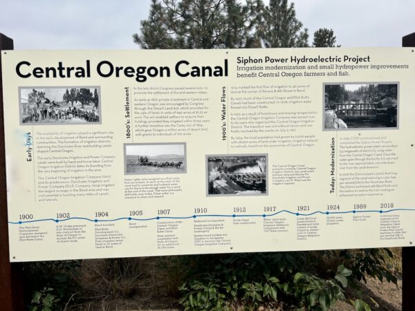
Irrigation Districts, which were responsible for damming the river and building canals along the Deschutes, played a significant role in the development of Bend. Early canals were built by hand, with the assistance of horse power. “Water rights were assigned on a first come, first-serve basis. A ranch at the start of the canal had to conserve and husband water use for there to be enough water for a ranch at the end of the canal. That same philosophy still holds sway today. Clean water is a resource to share and respect.” [On-site kiosk]
Larkspur Community Center / ~ Mile 5.0
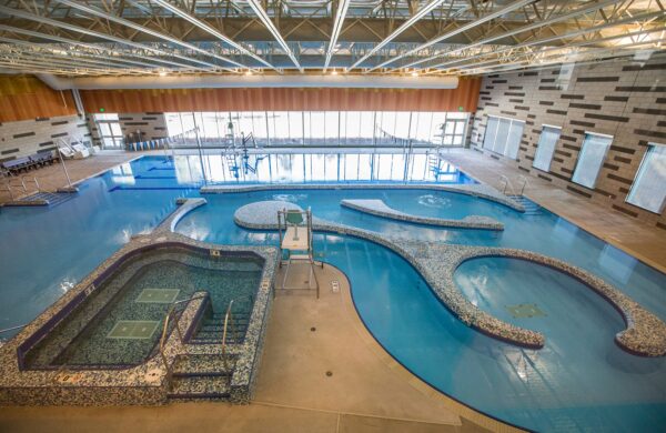
The former 14,000 square foot Senior Center was remodeled and expanded into a new community center that more than doubled its original size. Opening in 2021, the new Larkspur Center remains a great place for seniors, but now it’s a great place for folks of all ages, too! The center includes two dedicated functional fitness spaces; a 5,000 square foot fitness center with a walk/jog track, state-of-the-art equipment, and stunning Cascade views; a 4,000 square-foot aquatics center featuring a 135,000-gallon recreation and leisure pool with current channel and hot tub; several classrooms; and more! The pools, as featured in the picture, are a ton of fun! [Bend Park & Recreation District]
Larkspur Trail / ~ Mile 5.5
The Larkspur Trail, which guides you through the center of the Larkspur neighborhood, highlights the risks of unplanned development. Like much of Bend’s east side, large portions of Larkspur developed before the area was brought within the city limits. Since then, development has primarily taken place on smaller parcels of land. Because developers do not have to create a master plan for projects under 20 acres, small clusters of houses are scattered throughout the neighborhood with few routes to the main roads. [Bend Bulletin]
Pilot Butte Airport / ~ Mile 5.5
In the 1960s, local aviation enthusiasts built the Aerospace Acres residential neighborhood on what was then the outskirts of Bend. The neighborhood included the Pilot Butte Airport, which consists of an airstrip and a few hangers. The airport was built in the middle of two streets aptly named Cessna Drive and Airpark Drive. As Bend grew, other neighborhoods built up around Aerospace Acres. Today the airport sits in the middle of a large swath of residential neighborhoods. Nine residences have property that abuts the airstrip. Only residents of these nine properties are eligible to use the private airstrip. [Bend Source]
Pilot Butte / ~ Mile 8.5
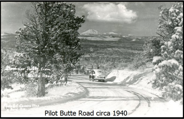
In 1922, Bend Press began raising funds to construct a road to the summit of Pilot Butte. It was estimated that it would take two weeks and $500 to construct the road. Within the month, the paper acquired sufficient donations, and the road was constructed. Bicyclists were quick to discover the joys of the new road. From an article in the July 31, 1922 Bend Bulletin: “Coasting down the new Pilot Butte road is the latest thrilling sport adopted by Bend boys who own bicycles. Of course, it’s a long way up to take a wheel, but where else can one coast steadily for so long a distance? A number of wheels were seen at the top of the Butte Saturday night.” [Deschutes Historical Museum]
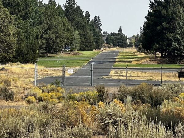
North Unit Canal Trail (Proposed) / ~ Mile 12.0
The North Unit Canal Trail will soon be a 10-feet-wide multi-use trail consisting primarily of gravel surfaces with occasional asphalt. Phase I of the project, estimated to be completed Summer 2025, will run between Canal Row Park and the Yeoman Road extension in NE Bend. There is talk of continuing to develop the trail west towards Highway 97. We encourage you to help support this trail development project. Read “Love Where You Ride!” to learn more. [Bend Park & Recreation District]
Deschutes River / ~ Mile 14.0
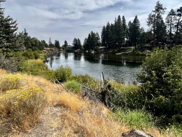
During the 1800s, settlers began to populate the region around Bend. Recognizing that the river was a valuable resource, they established communities along the Deschutes River. Along with developing buildings, roads, and farms, settlers constructed an extensive network of irrigation canals. While these changes were crucial for the area’s growth, they had adverse effects on the river’s ecosystem, modifying the river’s course and affecting fish, birds, and mammals residing in and along the river. Non-native fish species were introduced into the river, further jeopardizing the native fish populations in the river, including Redband and Bull trout. Efforts are currently underway to restore the river’s delicate ecosystem, returning the habitat and water quality to their original state. [On-site kiosk]
Old Swimming Pool / ~ Mile 15.0
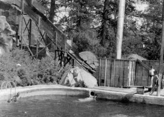
During the 1920s, Bend reportedly boasted the state’s most extensive outdoor swimming pool, located on the banks of the Deschutes River just downstream from Pioneer Park. The “Kirstis Tank” was a steel tank pool that measured 50 by 150 feet and held a staggering 330,000 gallons of water. The water for the tank was drawn directly from the Deschutes River, heated by a burner that utilized sawdust from Bend’s sawmills, and then returned to the river. To learn more, watch this cool video . Now, all that exists of the colossal swimming tank is a kiosk commemorating its historic existence. [Deschutes History]
Farewell Bend @ Pioneer Park / ~ Mile 15.0
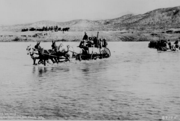
“In 1851, immigrant trains used this spot to ford the Deschutes River on their trek to Western Oregon. Upon departing, the earliest known wagon train named it Farewell Bend, and it is from this origin that the present city of Bend derived its name.” [On-site kiosk]
Old Powerhouse / ~ Mile 15.0
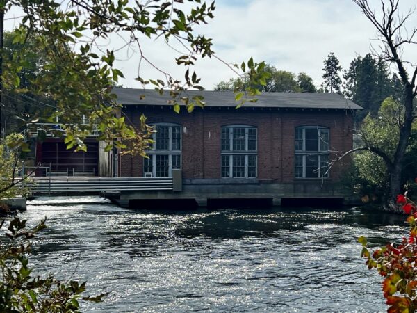
“The dam and powerhouse were built in 1910 and 1913 respectfully by the privately-owned Bend Water, Light and Power Company and were subsequently sold to the Pacific Power and Light Company (the current owner). The dam, which holds back the waters of the Deschutes River to form Mirror Pond, is 252 long, 14 feet high, and essentially unaltered since its completion. A 150-foot concrete gravity wall connects the dam to the powerhouse. The powerhouse contains three turbines that have a combined generation capacity of 1,110 kilowatts (still generating electricity today!). Like the dam, the powerhouse has undergone few changes since it completion in 1913 and is one of the oldest surviving buildings in Bend.” [Historical Marker Database]
Boardwalk / ~ Mile 15.5
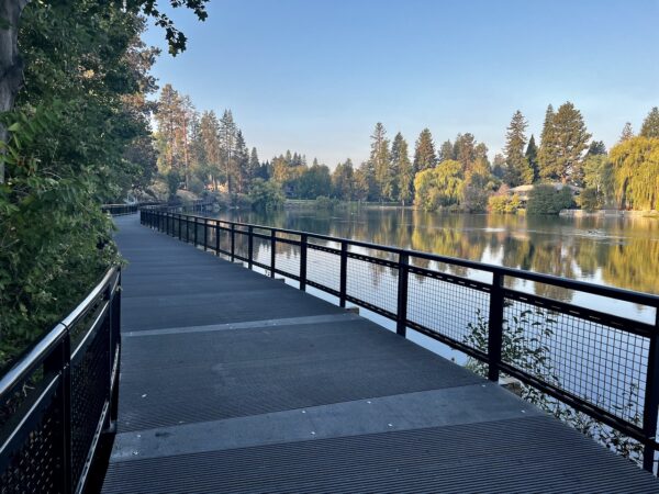
Completed in the summer of 2023, this boardwalk is part of a $7.3 million dollar upgrade to Drake Park by Bend Park & Recreation. The new boardwalk was constructed to replace an unsafe old boardwalk, address environmental issues, and complete connection of the trail from Pioneer Park to Drake Park. This is just one example of the leadership and great work by Bend’s park district. [Bend Park & Recreation District]
Whitewater Park / ~ Mile 16.5
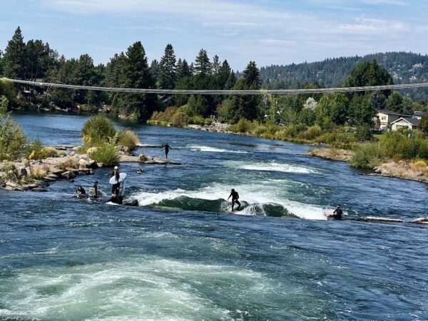
Whitewater Park is one of the best-known, human-engineered river-surfing wave parks in the country. It is open every day of the year from 5 am to 10 pm. Managed and owned by Bend Park & Recreation District, the park features four separate waves, more than 20 inflatable bladders that control the flow and change the shape and size of the waves, and three distinct channels. The Fishladder Channel provides a safe passage for those seeking a mellow float, the Whitewater Channel provides rapids for thrill-seeking kayakers and surfers, and the Habitat Channel provides a river environment essential to local and migratory wildlife. Watch the video in the sidebar to learn more about the Whitewater Park. [Visit Bend]
Mill A Building / ~ Mile 16.5
“The Old Mill District formerly housed two competing lumber mills. In 1916 the Shevlin-Hixon Lumber Company built a mill on the west bank of the Deschutes River, and Brooks-Scanlon Lumber Company built the ‘Mill A’ complex on the east bank. For the next 78 years, the mills dominated Bend’s economy, pumping money and business into the town. At their peak, the companies were two of the largest pine sawmills in the world, running around the clock, employing more than 2,000 workers each and turning out more than 500 million board feet of lumber a year…By 1950, the forests’ depletion led to the decline of Oregon’s logging industry…Brooks-Scanlon bought the Shevlin-Hixon mill in 1950 and closed it just four months later. The Brooks-Scanlon Mill A closed in 1983.” The Mill A building is now an office complex. [Wikipedia]
3 Smokestacks / @ Finish
The three smokestacks from the old city powerhouse are nearly all that remains of a mill that gave the revitalized Old Mill District in Bend its name. Two of the three smokestacks were originally erected in 1922, and the third stack was added in 1933. All stacks stand just over 200 feet in height. The powerhouse was gutted and renovated in the early 2000’s and currently houses an REI store. [Wanderlust Tours]
"No Caulks Allowed" Sculpture / @ Finish
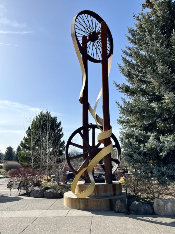
No Caulks Allowed was sculpted by artist Roger Fox in 2001. “The large steel wheels in this sculpture once ran the bandsaw or head rig in the Brooks Scanlon Lumber Mill, formerly on this site. Cut marks in the wheels show where the saw blade broke and cut into the steel. The title for the sculpture makes reference to the loggers who worked at the mill. They once wore spiked soled boots called ‘caulks of corks,’ and in an effort to keep their floors intact, restaurants, taverns, and retailers posted ‘No Caulks Allowed’ signs on their front doors.” [On-site kiosk]
When We Like to Ride This
This route goes most of the year, except when there is snow in town. We like this route outside of tourist season when the area is less busy. If ridden during the summer, we recommend an early start (prior to 8 am) to minimize exposure to heat and crowds.
Terrain & Riding
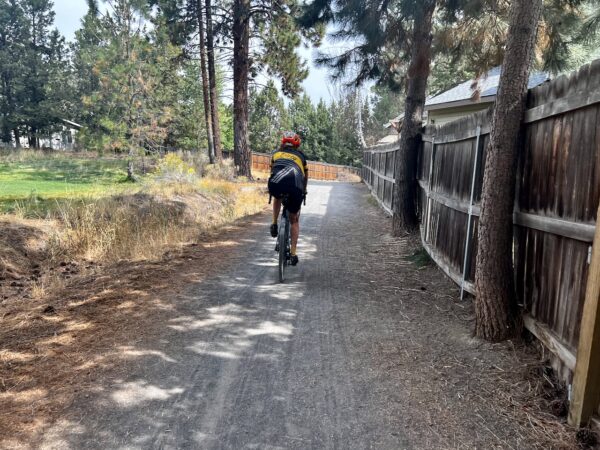
The ride starts in The Old Mill District near Strictly Organic coffee shop and the footbridge across the river. From there, ride the walking / bike path on the east side of the Deschutes River. Go slowly and enjoy the views. (Remember that little kids on bikes with handlebar streamers have the right of way!) After a mile or so, go under the Reed Market Bridge, wind your way through a bit of single track, and then “pop up” a hill and find your way up to a gravel canal road. (The canal is now buried below ground). The canal road will take you under Highway 97.
When you reach 3rd Street, there’s a new cross walk to guide you across four lanes of traffic. The trail then dodges behind a few businesses, where you end up paralleling Reed Market. After you navigate through Bend’s only double roundabout (we recommend you stick to sidewalks on this section), continue on the Lark Spur Trail that starts at the Bend Senior Center. This trail will jet you over to Pilot Butte through quiet neighborhoods. The route climbs to the top of Pilot Butte where you get terrific views in all directions. And … at the top there are several informational kiosks on the area geology. You can skip this part, but it is special!
Buzzing back toward the center of town, wiggle through an industrial area on gravel. Make a right turn onto Butler Market road, which after a little car dodging, intersects with the River Trail. This trail winds you back to Drake Park and Mirror Pond. From here, pedal by the Whitewater Park (perhaps you will see big wave surf legend Gerry López surfing the rapids), and head back to the Old Mill.
The Start
The wooden footbridge at the Old Mill District.
Food & Water
- As the ride takes you around town, there are numerous opportunities for refreshments along the route.
- Water & toilets are available at Larkspur Center (mile 4.7).
- Toilets are available at summit of Pilot Butte (mile 8.5).
Route Notes
As you will be traveling on multi-use paths with other cyclists, walkers, joggers, and recreationists of all ages, please limit group size to 4 or fewer riders.
This is an urban ride. You will encounter traffic, and in several cases, you will ride alongside automobiles. For this reason, we recommend using a red blinky light with a rear-looking radar detector, such as the Garmin Varia.
For safety, ride the sidewalks in the areas we have indicated on the map. Also, use the signals at crosswalks to cross busy intersections.
Route Options
If you wish to reduce the elevation on this route, you can skip the climb to the top of Pilot Butte at mile 7.2. In this case, the ride is mostly flat with a minimal elevation gain of 600 feet, with one short pitch of 6% on pavement. Keep in mind, though, that if you skip out on Pilot Butte, you will miss out on great views and information kiosks about Oregon’s geology. Even if you have to walk, we highly recommend making the trek to the top of the butte.
If you wish to increase mileage, you can combine this ride with the Westside Tour. Nearly all of the pedaling would be within the city limits of Bend, giving you a ride total of 34 miles. To tack on the Westside Tour, go right onto the River Trail at mile 13.8. You will intersect the Westside Tour route at mile 1.9.
Love Where You Ride! Learn More
 Bend Park & Recreation is doing a marvelous job expanding bike-friendly infrastructure in Bend. Part of this Townie route includes a section of the proposed North Unit Canal Trail. We encourage you to submit comments via email (info@bendparksandrec.org) to the park district in support of future trail development. If you want quick’n’easy verbiage to submit, consider copying and pasting the following: “I am a cyclist who loves to ride in Bend. I very much appreciate and support Bend Park & Recreation’s efforts to expand the community’s bicycling infrastructure, allowing for more miles of safe and enjoyable riding. Thank you for all that you do.”
Videos
The Ride! Townie
A quick 2-minute video of what to expect on your ride!
Bend Whitewater Park
This video explores Bend's Whitewater Park. Take a peak at the computer controlling the 20+ inflatable bladders that provide the park's thrilling whitewater waves. Also get a glimpse of the historical dam as well as the present-day engineering marvel that allows for three distinct river channels.
Podcasts
"Greetings From" Murals ... Fun Art Across Central Oregon
The retro “Greetings From” murals across Central Oregon bring back fond memories of the postcards that were a huge hit with tourists in the mid-20th century. These playful murals are part of The Central Oregon Mural Trail and were created by Karen Eland and Katie Daisy for [...]
Keep it Local! Learn More
Ridden and Reviewed by:


 Behind every route is scouting, mapping, storytelling, and a whole lot of pedal power.
Have you ridden this route? Got a question? Join the discussion!