Tom Rock


Caution! We do not provide turn-by-turn directions in our GPX files. Those are auto-generated by your bike computer and are usually less than 70% accurate. Learn more.
For help loading a GPX file onto your bike computer, go here.
DownloadHighlights & Remarkable Spots
The Climb / Gravel (mostly) / ~ Miles 0 to 15.5
The route begins just outside of Mill City, Oregon. Mill City was founded in 1886 and named after the Santiam Lumber Company’s mill which is still on the current city’s site.
Outside of Mill City, where the gravel beings, the road initially pitches up at 7-9% and then settles into more moderate grades of 4-6% at mile 5. The climbing is through a dense forest with pines, maples, oaks, and undergrowth of thick ferns and blackberry bushes.
The Santiam State Forest is ~47,000 acres in the Northern Cascades and was heavily logged between 1880-1930. When most of the trees were harvested, timber companies let the lands go back to the counties and the counties gave much of the land to the state. Oregon state forests or “working forests” often make profits for the local communities and community programs, providing Oregonians with various economical, environmental, and social benefits. Although state forests are “publicly-owned timberland”, the forestry permits hiking, biking, horseback riding, and camping in most forests. You can explore more of Oregon’s state forests here.
Between miles 8.8 and 9.7 there are several small ridge viewpoints looking north to the North Santiam State Forest where you can see the devastation of the 2020 Labor Day fires. Historic drought conditions worsened by climate change, in combination with historic winds caused the fires to grow from 500 acres to over 130,000 acres in just 24 hours. You can read more about Restoring the Santiam State forest here.
At ~ mile 10 you swing around the ridge going from a westerly direction to an easterly direction. The views are now to the south (while the first 11 miles of views are to the north.) This is a very unique feature of this route.
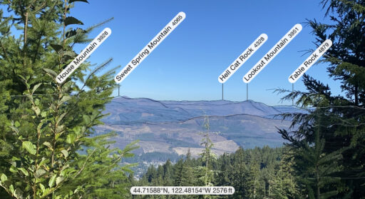
Tom Rock Viewpoint / ~ Mile 15.4
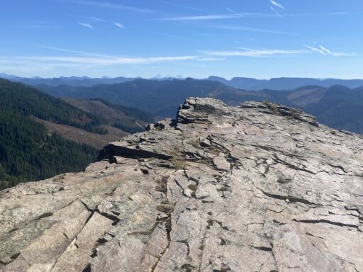
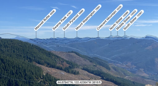
At mile 15.4, the high point of the day, look carefully for where the track goes out to your right a little bit. It can be hard to find the trail, but it leads out to Tom Rock. It is so worthwhile! You get views of the Three Sisters, Mt Washington, and Three Fingered Jack.
Note, on the ESRI and USGS maps Tom Rock is labeled as High Rock. But … this is spot all the locals consider as Tom Rock.
The Descent / Gravel (mostly) / ~ Miles 15.5 to 31
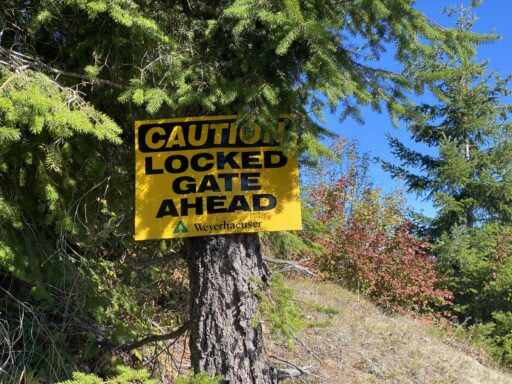
Just after Tom Rock, the route exits the Santiam State Forest and enters Weyerhauser’s private property. This is marked by a gate. Bike and walk-in access are allowed.
At mile 16.2 there is a tricky turn. Stay left when in doubt. This marks the beginning of a short (mile 16.2 to 17.6), steep, sketchy connector “road”. It has several drainage ditches cut across it, some off-camber turns, and larger, sharp flint-type rocks. Some riders may want to walk / hike this section. This is the most technical sector of the day.
~200 yards down the east side of descent, you will pass a gate. After the gate, the technical demand increases as the section traverses through a recently logged area. The road becomes more primitive and there are l ~Mile 17-17.5 are the most technical, steep, and demanding sections of the day.
Once you’re done with the technical section [mile 17.5], the ride transitions back into the forest for great riding on hard-packed gravel again. Gradings return to more moderate ranges of 3-4%. This portion of the descent is much more undulating than it appears in the elevation profile. You will pedal, quite a bit!
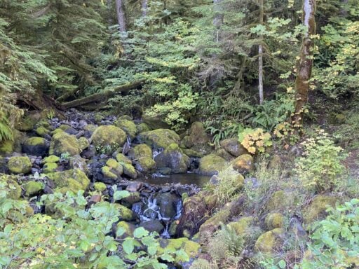
At ~ mile 22, Look carefully as there is a hidden waterfall on your left. The descent has some really cool streams you cross over and ride next to for a while.
Just before mile 26, you begin the last pitch down through the forest. It is steep! You’re grabbing the brakes with both hands and squeezing hard. There are spots where it is 17-19% downhill.
When back on pavement it mellows and you get a nice spin of the legs to cool down.
When We Like to Ride This
On a day with clear skies and good visibility. Spring through fall.
In the summer, an early morning start on a hot day could make for a great ride as you get into the climb quickly so you can climb when it is cool and descend more in the heat of the day.
Do not do this ride when it is wet. It could be a slippery, muddy mess.
Terrain & Riding
Overall this route is a good honest effort, the sustained climb will work you!
Warning: Right after the high point of Tom Rock is a dicey, rugged downhill. It’s hardly long enough to whine about, maybe 3/4 of a mile where those mountain biking skills will come in handy. You roadies will be walking for sure. Five bucks say you’ll miss the turn for the downhill.
You will like this route if you like sustained climbing, vista views, lush forests, and a long descent.
The Start
The start of the route begins at Kimmel Park in Mill City; a beautiful little park on the Santiam River surrounded by trees and mountains just a few minutes off Highway 22. The park has a nice picnic area, flush toilets, and water on site. This would be a good post-ride picnic spot!
Food & Water
- None.
Route Notes
45 mm tires or larger or possibly a hardtail mountain bike. The technical section will be tough on almost any bike.
Ride the route in the direction as mapped, the opposite way could be brutal due to the technical section.
We recommend a red blinking light with rear locking radar detection. There is some light traffic leading out on the road.
If you are riding in the fall, wear brighter colors as you will come across hunters in the area.
Route Options
This option avoids the technical descent but still includes the Tom Rock viewpoint. However, out to Tom Rock is a short out and back leg. This version adds 3.2 miles and 400 additional feet of climbing.
Videos
The Ride! Tom Rock
A quick 2-minute video of what to expect on your ride!
Keep it Local! Learn More

Ridden and Reviewed by:


 Behind every route is scouting, mapping, storytelling, and a whole lot of pedal power.
Have you ridden this route? Got a question? Join the discussion!