The Pawn
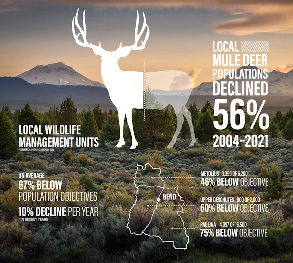
This area is winter migration habitat (December 1 to March 31) for mule deer and elk. Please limit your group size to 4 or less. Dusty during the summer.


Caution! We do not provide turn-by-turn directions in our GPX files. Those are auto-generated by your bike computer and are usually less than 70% accurate. Learn more.
For help loading a GPX file onto your bike computer, go here.
DownloadHighlights & Remarkable Spots
Sisters (the town) / ~ The Start
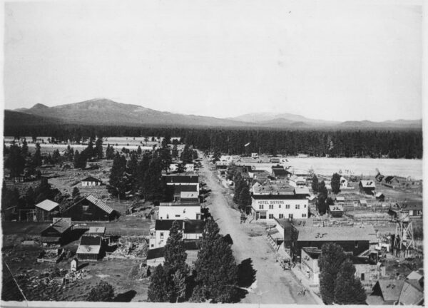
The 1st Oregon Volunteer Infantry in 1865 established Camp Polk three miles northeast of present-day Sisters. Camp Polk was a military camp intended to protect miners and settlers from Native Americans but lacking actual conflict, it was soon abandoned. The area was subsequently homesteaded in 1870 with a store and post office, the latter being moved 3 miles south. The city grew from a sheepmen supply station to a lumber town and was officially founded in 1946. The lumber industry dried up in the 1960s and Sisters transitioned to retail and recreational tourism as an economic driver. History buffs might enjoy this virtual tour of historically significant sites in Sisters.
Black Crater / ~ Mile 7
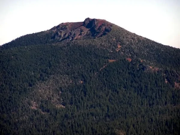
Black Crater is a steep-sided shield volcano in the Cascade Range. Ice age glaciers carved a large cirque into the northern flank of the mountain making the shield volcano somewhat difficult to recognize. From here you get one of the best looks of Black Crate in Central Oregon.
A shield volcano is a type of volcano named for its low profile, resembling a warrior’s shield lying on the ground. It is formed by the eruption of highly fluid (low viscosity) lava, which travels farther and forms thinner flows than the more viscous lava erupted from a stratovolcano. Repeated eruptions result in the steady accumulation of broad sheets of lava, building up the shield volcano’s distinctive form. [Wikipedia]
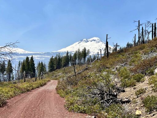
Pole Creek Fire / ~ Mile 10
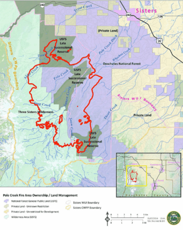
On September 9, 2012 lightning struck the surrounding areas burning about 41 square miles, the largest Central Oregon fire in 2012. The area remained closed until mid-May 2013, when enough of the downed trees were cleared to re-open the trails. Pole Creek was known as an area thick with lodgepole pines and subalpine firs, not very scenic because the thick cover blocked distant views. Today, the mountain views from the area are jaw-dropping.
Three Sisters Viewpoint / ~ Mile 21
Around mile 21, the route starts to descend a wide gravel road alongside a cliff with BIG views of Tam McArthur rim and North Sister. This is about the start of the descent so it is worth stopping for a moment to see the views from the top before descending back into some covered areas.
Whychus Creek / ~ Mile 23
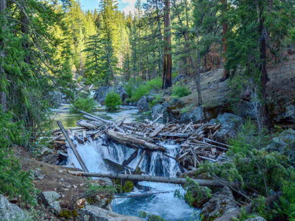
Prior to the arrival of American settlers in the Upper Deschutes Basin in the late 1800s and early 1900s, Whychus Creek was a source of fish and water for the native tribes who lived and traveled through the region. Then settlers came. Irrigation diversions were established and the summer months would see the creek occasionally run dry as irrigation demands increased. By 1912, a dry creek was a regular occurrence. Between 1960 and 1999, two out of every three years saw the creek run dry in summer.
In 1999, changes in the way the creek was viewed led a collaboration of farmers, government officials, and conservation organizations to start working together to bring back summer streamflow to the creek. That was the beginning of a massive effort spanning the next 20 years to restore the creek to health in order to support the reintroduction of fish migrating up river from the ocean to spawn in freshwater. [The Nugget Newspaper]
Skyline Forest / ~ Miles 30 to 32
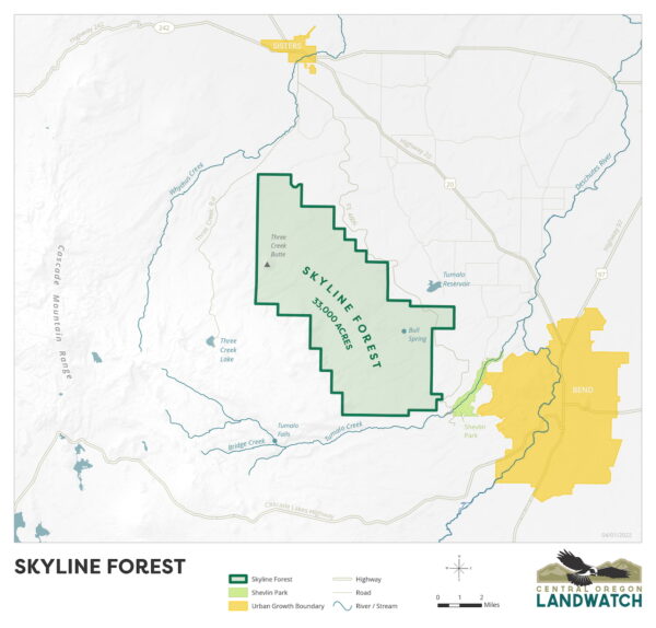
Without access to Skyline Forest, this route as is would not be possible. Skyline Forest is under threat of development. Listen to the podcast in the right side panel to the to learn more or give this a read.
Rooster Rock Fire / ~ Mile 32
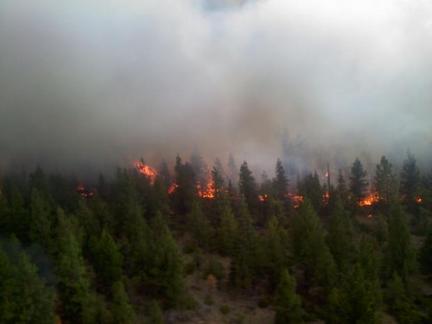
The 2010 Rooster Rock Fire burned 6,134 acres south of Sisters primarily on private land in the Skyline Forest, then owned by Fidelity National Timber Resources. Nearly 1,000 firefighters worked to contain the blaze. While hotspots still smoldered after containment, the U.S. Forest Service and Oregon Department of Forestry began restoration efforts on the affected public land, limiting efforts on the private land to repairing damage due to fire suppression efforts.
Peterson Ridge Trail System / ~ Miles 26.8 & 36.8
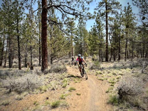
Caution! It is easy to miss these turns into the Peterson Ridge Trail System. It is quite shaded through the trees and low in technical difficulty. But flowy, slightly downhill, and fun! “The Peterson Ridge Trails in Sisters were originally constructed in 1989 as a mountain bike trail network consisting of a combination of single-track and old forest service roads. In 2008, a major expansion of the network increased the amount of single track to over 20 miles and included signage and trail markers to aid riders in navigation.” [Bend Trails]
When We Like to Ride This
Late spring through early June, when the peaks are still snow-covered. However, the ride can be done until the first snow of winter, but from mid-June on, the route gets more rugged, beaten up and sandy. Not the best time to ride.
Terrain & Riding
You start on a small section of pavement before turning onto a narrow dirt road that winds its way up on soft, loose red tuft with open sightlines. At mile 8, you regain a proper gravel road and continue to climb on moderate grades through forest and old burns. Miles 13 to 17 are the most rugged and demanding of the day, old Forest Service track. This can be skipped, see the Notes & Options tab.
The descent has a few rugged and steep sections, including a mile-long chunky rock section at ~ mile 22.3 and two sectors (beginning at miles 27 and 37) of flowy, fun(!) single-track before returning to town on pavement. Watch your navigation carefully for the turns onto the single-track; they are easy to miss!
What do you get for efforts? Big mountain views with some of the best views of Tam McArthur Rim in the entire Central Oregon area.
The terrain is a mix of pine forest and recent burns. The burns provide exceptional views.
The Start
Village Green Park. Picnic area, restrooms with running water, and a covered gazebo. It is just a few blocks from downtown Sisters, Oregon.
Food & Water
- None
Route Notes
We recommend a red blinky light with rear looking radar detector (i.e. Garmin Varia) for the initial paved sector and for several of the proper gravel roads along the route. On gravel we find it difficult to hear traffic approaching from behind and a Varia device really helps.
Route Options
- There may be an option to pick up the single-track trail at the high school at mile 1.4 and then connect to the original route at mile 3.6. If you give this a go, please let us know what you find by leaving us a comment below. Or better yet, send us your GPX file with a comment.
- You can skip the rugged 4-mile sector by keeping straight at mile 12.7 and reconnecting with the original route at mile 20. RideWithGPS map. Download GPX File.
Love Where You Ride! Learn More
 A short but important sector of this route is within the Skyline Forest, private land open to limited recreation use (including bikes). However, there is the possibility and threat that this land could be built out and no longer be accessible to the public. Central Oregon Land Watch has taken a leading role in working to protect this forest and keep it open to the public. We encourage you to take a few minutes to learn more.
Videos
The Ride! The Pawn
A quick 2-minute video of what to expect on your ride!
Trail Etiquette (Horses, Hikers & Bikers)
Whether you like to hike, bike, or ride a horse, we all want to enjoy our trails safely. Learn how to share the trail respectfully!
Podcasts
Skyline Forest (It’s not public land?)
What! It is not public land? Ben Gordon, Executive Director of Central Oregon Land Watch, joins us to discuss a large area of private land called Skyline Forest and what the future entails for this 33,000 [...]
Be Informed!
Keep it Local! Learn More
Ridden and Reviewed by:


 Behind every route is scouting, mapping, storytelling, and a whole lot of pedal power.
Have you ridden this route? Got a question? Join the discussion!