Dirty Freehub
Favorites Sign In Search
  • Search
  • Donate
  • Gravel Routes
    • Explore by Region
    • Explore by Type
    • Explore by Collection
  • All Access®
  • Stories
    • Bike Life
    • Culture & History
      • Central Oregon
      • NE Oregon
      • Bend Trails
      • Death Valley
    • People & Places
    • Lands
      • Arizona
      • Central Oregon
      • NE Oregon
    • Love Where You Ride
  • Events
  • User Guide
    • Route Types
    • How We Rate Routes
    • Using the Map
    • Loading a GPX File
    • Glossary
    • FAQs
  • Inside DF
    • The Team
    • Our Missions
    • Impact Reports
    • Press
    • Sponsors
  • Store
    • Gravel Guides
    • Merch
  • Donate
  • Cart
  • Sign In
  • Favorites

South Junction

5 Star Route / Madras, Oregon / Published: Apr 2022 / Directions
Save to Favorites Remove from Favorites
Lower Deschutes River
South Junction
South Junction
*
Route:
Out & Back | 23 mi
*
Gain:
2,300 ft
*
Surface:
100% gravel
*
Technical Difficulty:
Moderate
*
Navigation:
Straightforward
*
Locale:
Remote
*
Tire Suggestion:
40 mm
*
Options:
---

The highlights of the South Junction include the majestic views of the meandering Deschutes River and the fascinating history of the railroad wars. But there’s even more! Traversing the high desert covered with grasses, bush, and scattered Juniper trees, you’ll see amazing views of the Cascade Mountains, ranging from Mt. Bachelor in the south to Mt Hood in the north.

As you make your way towards the Deschutes River on this out & back route, you’ll drop down into the Deschutes River Canyon, a deep rimrock-lined canyon that ranges from 900 feet to 2,600 feet in depth. You’ll pass steep basalt cliffs that are stunningly beautiful! Once you arrive at the Deschutes River, you’ll see waters that are truly wild and scenic, as the Deschutes River was designed a National Wild and Scenic River in 1988.

Created by Congress in 1968, the National Wild and Scenic Rivers System was enacted “to preserve certain rivers with outstanding natural, cultural, and recreational values in a free-flowing condition for the enjoyment of present and future generations.” The goal is to protect and preserve the unique character and attributes of these the nation’s most pristine rivers while balancing recreation, water quality, fish and wildlife, and other values. [Oregon Wild]

Once at the river, you’ll get a taste of the old railway history.

The Deschutes Railroad War began in 1908 when two competing railroad companies, the Deschutes Railroad and the Oregon Trunk Railway, started racing to build a line from the mouth of the Deschutes River across central Oregon. The Deschutes Railroad, a Union Pacific subsidiary, was owned by Edward H. Harriman and the Oregon Trunk was owned by James J. Hill.

Harriman was the first to begin construction and, after surveying the area, he decided that the eastern side of the river would be the best route. Soon after, Hill began building his own line on the western side. Later on, however, in the Deschutes River Canyon, the two roads actually ran side-by-side or shared the same rails and terminals. Over the following years, there were multiple legal disputes to decide which company should have sole access to the canyon, but railroad workers went even further. Competing construction crews would often blow up the other side’s supplies by igniting their black powder stores. They also dumped boulders onto camps below and engaged in small gunfights. Casualties remained light though and by 1912 the two railroads were operating on mostly separate lines, thus removing the cause for hostility. [Wikipedia]

As you return from whence you came, enjoy the changing views as you experience them from the opposite direction.

Read More
Map
Brown = gravel / dirt road
Blue = single track
Red = paved road
Purple = paved bike path
GPX Download
(Version 1.0)
Learn More

Highlights & Remarkable Spots

Shaniko Flats / ~ Mile 1.0 & 22.5

Hotel Shaniko

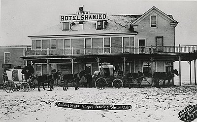
The route begins high above the Deschutes River in the southwest corner of the Shaniko Flats. The flats were named after the nearby town of Shaniko. “No town in Oregon has seen more rapid growth and decline in a single decade than Shaniko. From 1901 to 1911, the town went from being the Wool Capital of the World to the liveliest ghost town in the state. Shaniko, incorporated in 1901, was at one time the fifth largest city in Wasco County, shipping millions of pounds of wool and carloads of grain and livestock to market each year.” [Oregon Encyclopedia]

Rattlesnake Fire / ~ Miles 8.0 - 15.0

South Junction

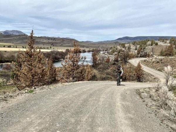
In the vicinity of South Junction, you’ll notice trees bearing scars of a wildfire. In 2021, the Rattlesnake Fire consumed 5000+ acres of grass and shrubs, with a mix of sparse Juniper trees. The fire burned on both sides of the Deschutes River. [Central Oregon Daily]

South Junction / ~ Mile 10.0

South Junction

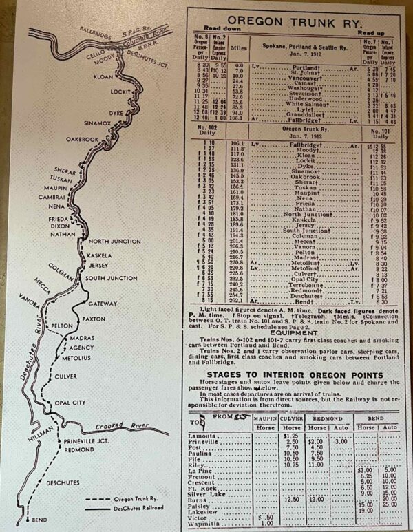
In 1908, construction of two competing railroads commenced at the junction of the Deschutes and Columbia Rivers — the Deschutes Railroad and the Oregon Trunk Railroad. The two railroads faced legal disputes as both competed for access to some of the same ground. The disagreements quickly turned into a railroad war, marked by rival construction crews blowing up each other’s supplies and engaging in gun battles, which resulted in injuries and even deaths. Despite the conflicts, by 1910, the two companies began operating on mostly separate railroads on either side of the river. [The Oregon Trunk and Deschutes Railroads]

South of this point by ~ 1 mile is one of the points where the Oregon Trunk Line and the Deschutes Rail line split. The Oregon Trunk Line stayed along the river whereas the Deschutes Rail line started to head inwards and east towards Gateway.

For the full history of the railway war, check out “The Deschutes River Railroad War” by Leon Speroff.


Lower Deschutes River / ~ Mile 10.0 - 13.0

Lower Deschutes River

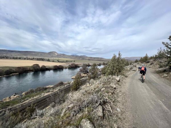
This section of the Deschutes River is protected by the National Wild & Scenic River Act. “Protection under the National Wild and Scenic River Act includes the prohibition of damming or otherwise altering the river in any way including dams, bank alternation, as well as any mineral, gas, or oil extraction. It also includes a buffer corridor that can be either 1/4 or 1/2 mile on either side of the river. Within this buffer activities that would degrade the values for which the river was designated are not allowed – potential values include fish, wildlife, recreation, scenery, geology, cultural, etc.” [Oregon Wild]

Ride Details

When We Like to Ride This

The best riding times are spring, fall, and on a warm, sunny winter day. You want to do this ride when you have clear skies, the mountain views are stunning. Summer can be hot, hot, hot! No parking permit required.

Terrain & Riding

The terrain is classic high desert, with grasses, bush, and scattered Juniper trees. The roads are hard-packed with an overlay of loose gravel.

At ~ Mile 8, you being the descent of the Deschutes Canyon to the river. The gradients are 6 to 10%, but on the descent, it does not feel that steep, more like 5%.

The route ends in a Y. The left branch brings you to the rail crossing, near the site of the historic South Junction. The right branch of the Y brings you to the South Junction campground and some beautiful river views.

Overall, there is a lot of elevation gain for the mileage. The climb out of the river is more demanding than appears.

The Start

Lat / Long: 44.920628, -120.947696

A dirt pullout on the west side of Highway 97 just at the intersection of Highways 97 and 197.

Food & Water

  • None.
Notes & Options

Route Notes

  1. This is an out & back route that ends where private property signs are located. Please respect property rights and do not go past the posted signs.

Comments

Have you ridden this route? Got a question? Join the discussion!

Love Where You Ride! Learn More

The lower Deschutes River (which you see on this ride) is protected by as a National Wild & Scenic River. To learn more about Wild & Scenic rivers, give a watch to the video below. It is quite good!

Videos

The Ride! South Junction

A quick 2-minute video of what to expect on your ride!

Wild & Scenic Rivers

Learn about how the Wild & Scenic River designation came about and why it is so important today. A must watch!

Deschutes Driftwood

A historic (~ 1916) Hollywood video telling the story of a hobo along the tracks of the Deschutes rail line. The video, produced by the American Educational Film Corporation, has excellent scenic footage! (Caution: This film contains insensitive and racial content indicative of the era.)

Keep it Local! Learn More

Beverage

Madras & Maupin

After your ride, there’s a good chance you’ll pass through either Madras or Maupin as you head on to your next destination. Consider dropping some coin to support one of local brewpubs or eateries. Both Madras Public House (Madras) and Mt Hood Brewing Company (Maupin) are great choices.

Ridden and Reviewed by:

KevinE

KevinE / Team Dirty Freehub

He should have “Never Stop Exploring” tattooed on his chest! He loves adventures on bikes and is a Co-Founder of Dirty Freehub.

LindaE (aka Gravel Girl)

LindaE (aka Gravel Girl) / Team Dirty Freehub

She loves a good day of gravel, like most people like a good book. She’s always amused by the outdoors and the wild adventures. Gravel Girl is a Co-Founder of Dirty Freehub.

Explore Similar Routes:

Trains

Sign Up for the Dirty Freehub Newsletter

info@DirtyFreehub.org
Terms of Service Privacy EEO Policy Our Values
Dirty Freehub is 501(c)3 non-profit organization.
©2025 Dirty Freehub :: All Rights Reserved :: Website Design
Cleantalk Pixel

We Need Your Support!

Dirty Freehub is a 501(c)3 nonprofit funded by generous donations from riders like you!

  • $25 Keeps the lights on (web hosting, technology tools, insurance, etc.)
  • $50 Keeps lights on + up to date route conditions
  • $100 Continued route development
  • $200 Fully documented route guide
  • $200+ Gravel Girl giggle of gratitude

Donate Today