Shaniko!


Caution! We do not provide turn-by-turn directions in our GPX files. Those are auto-generated by your bike computer and are usually less than 70% accurate. Learn more.
For help loading a GPX file onto your bike computer, go here.
DownloadHighlights & Remarkable Spots
The Dalles - Canyon City Wagon Road / ~ Miles 0 to 8
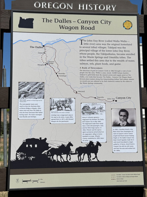
The first eight miles of this route follow a section of the 185-mile Dalles–Canyon City Wagon Road, a major freight and stage route built in the 1860s to link the Columbia River port of The Dalles with the booming gold mines of Canyon City (near present-day John Day) in eastern Oregon. Much of the road operated as a toll route, with different companies charging wagons, livestock, and stagecoaches for use.
The town of Antelope served as a stagecoach stop along the way to the mines, and a post office was established there in 1873, with Howard Maupin serving as the first postmaster.
Click the image to zoom in.
Antelope / ~ Mile 8
In the early 1980s, Antelope underwent one of the most dramatic transformations of any small town in the American West. The Rajneesh movement purchased the nearby 64,000-acre Muddy Ranch and founded the commune of Rajneeshpuram, drawing thousands of followers to the remote region. As members moved into Antelope and registered to vote, they gained political control of the town. A 1982 attempt by longtime residents to disincorporate Antelope failed, and in 1984 the town was officially renamed Rajneesh, Oregon, placing it at the center of national and international attention.
A series of criminal revelations—including a bioterror attack and broader conspiracies orchestrated by commune leaders—led to the downfall of Rajneeshpuram in 1985. That November, the remaining residents voted unanimously to restore the town’s original name, and by 1986 Antelope reclaimed its identity. For a more in-depth look at this history, see the Rajneeshee Dirty Freehub ride guide.
Priday Ranch / ~ Mile 13 to 16
About three miles to the southwest lies Priday Ranch Preserve, highlighted in this two-minute video.
Priday Ranch is a 4,973-acre preserve that protects roughly 11 miles of Trout Creek, Antelope Creek, and Ward Creek. Trout Creek alone contributes up to 25% of all steelhead production in the Deschutes River. The preserve also hosts more than 80 beaver dams and lodges (listen to our beaver podcast), along with scattered populations of the rare hedgehog cactus along the canyon rim.
Click the image to zoom in.
Mt Jefferson / ~ Mile 20.1
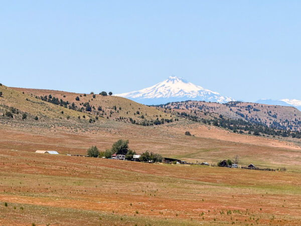
Folklore has it that the summit of Mt. Jefferson is exactly where Linn, Jefferson, and Marion counties meet, making it a triple point in Oregon’s political geography. But that is not true!
The summit is entirely within Jefferson County, with Linn and Marion county lines crossing nearby ridges and flanks, not converging precisely at the very top.
The peak was named by the Lewis and Clark Expedition in 1806 in honor of President Thomas Jefferson.
Eagle Valley Ranch / ~ Mile 21.5
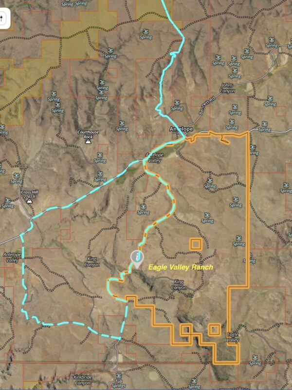
Eagle Valley Ranch is a fourth-generation, 11,000-acre cow–calf operation running roughly 700 head of cattle.
Ranches in this region, including the Muddy Ranch just a few miles away, were first established in the late 1800s by livestock companies that grew into vast sheep and cattle empires, using home ranges here and summer pastures in the Ochoco Mountains. During the early 1900s, Antelope thrived as a major freight and wool-shipping hub before declining as rail and highway routes shifted toward Shaniko and other towns.
Within this broader history, Eagle Valley Ranch stands out as one of the area’s enduring privately owned operations—steadily working through the booms, busts, and cultural upheavals that have shaped central Oregon’s ranching country.
Click the image to zoom in.
Cascade Volcanic Arc Viewpoint / ~ Mile 30
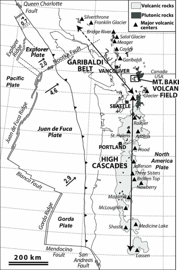
On a clear day, you can see a sweeping arc of volcanic peaks—Mt. Bachelor, Broken Top, the South and North Sisters, Mt. Washington, Three Fingered Jack, Mt. Jefferson, Mt. Hood, Mt. St. Helens, and Mt. Adams. These mountains form the spine of the Cascade Volcanic Arc. Their activity is driven by the small Juan de Fuca Plate, located just off the coasts of Oregon and Washington, which is slowly being forced beneath the North American Plate. This subduction melts rock deep underground, producing magma that fuels the Cascade volcanoes and has led to powerful eruptions, including the 1980 eruption of Mt. St. Helens.
Click the image to zoom in.
Credits & Acknowledgements
This ride guide is funded in part by Visit Central Oregon.
When We Like to Ride This
We really like this route in late spring and early summer, when the fields are green, and the flowers are in bloom.
Do not ride when wet or muddy. Do not ride when it’s windy; this route is exposed—high ridgelines and open prairies. Summer can be hot!
Terrain & Riding
The beginning of the ride (all paved, quiet road) is big and open. Rolling grasslands. Sage. Views for miles. It is rolling and undulating, gaining ~ 380 feet over 4 miles.
At mile 4.5, you drop into a super cool winding descent (with switchbacks!) into Antelope Valley. It is take your hands off the brakes and let it rip kind of riding! Drop 1000 feet over 4 miles, the steepest gradient being 5%.
In Antelope Valley, you have farm and ranchlands. Antelope Creek to the left and basalt rock outcroppings to the right. Look for hawks. Where it is not irrigated, it is sagebrush.
At mile 13.5, you turn left onto Tubb Springs Road. Expect a change of character: creeks, hidden canyons, and chunkier, more rugged hills. Initially, you climb, getting big views to the north and east over Antelope Valley.
At mile 18.5, turn left onto Upper Tubb Springs Road. This is the crux of the ride. A seldom-used county road that can be sandy, chunky, and rutted. It really depends on when it was last graded. This sector lasts 2.5 miles until you return to a proper gravel road. The end of the sector is noted by the Eagle Valley Ranch entrance to your right.
At mile 25, return to the pavement. Air up! Spin into Antelope. Climb the hill (Antelope grade) that was so fun to descend on the way out. From the crest of the climb, descend gradually back to Shaniko. Enjoy the distant mountain views.
Don’t forget the last little popper hill (small), just before Shaniko!
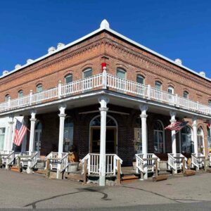
The Start
Park near the Shaniko Hotel on E Street. Public restroom nearby.
Food & Water
- ~ miles 8 and 26.5 / Antelope Market
Route Notes
There is a lot of pavement on this route, quiet paved roads, but you are sharing the road with cars. Thus, keep your group size small. Ride in a tight formation so it is easier for cars and trucks to make a pass around your group. Ride with a red blinky light like a Garmin Varia. And give a wave!
This is one of those routes where we recommend making air pressure adjustments. Start the ride with tire pressures suited to road riding on fatter tires, something like 40 psi+. At the beginning of the gravel sector, air down to your preferred gravel pressure, most likely something at or below 30 psi. And then, when back on pavement, air up to road-riding pressure levels. This may sound tedious, but it makes the ride so much more enjoyable!
We have rated this route as technically demanding due to the Upper Tubbs Springs road sector, which is 2.5 miles long and starts at mile 18.5.
Note that the Upper Tubb Springs road is a public road, used mostly to move farm machinery and wrangle cattle. It is a dirt road, not a proper gravel road. It can have sections of sand. It is seasonally closed by a gate at Eagle Valley Ranch when it is too muddy for vehicle traffic.
Also, watch out for goatheads in this area. They’re most common in late summer and fall.
Goatheads are those prickly, hard thorns that puncture your tire and then stick in your tire. We have found that the best solution to riding in goat head country is to:
– Use tubeless tires
– Top off your tire sealant before the ride
– Use a tire insert like CushCore
– Carry extra sealant and a valve core removal tool, to add more sealant to the tire
– Carry something like Dynaplugs for those holes that do not seal quicklyGoat heads are invasive, and your tires will spread them if you ride with the head inserted into the tire for a distance.
We recommend riding the route in the mapped direction only. This way, through the rugged Upper Tubbs Springs road sector, the route is mostly downhill and much less strenuous. Going the opposite direction (north to south) would mean tackling a steep, rocky, sandy, and very difficult climb.
Route Options
Shorter / Antelope Start
- 19 miles with 1,500 feet of gain, ~ 65% gravel
- Park at the Antelope Market and RV Park on Main Street. Noted on the map with the “P” icon. Self-serve snacks, lodging, showers, bike stand and more.
- Start Lat/Long: 44.910689, -120.723320
Love Where You Ride! Learn More
 In Antelope, one person is quietly reshaping the way riders experience this tiny high-desert town: Brandie McNamee. When the old café—once the community’s gathering place—sat abandoned for years, Brandie stepped in with a vision to bring Antelope back to life and make it a true stopover for cyclists. She and her family purchased the old property and began transforming it into the Antelope Market & RV Park, a warm, functional hub for riders rolling through the valley.
Brandie has chased grants, partnered with local tourism groups, and worked with Dirty Freehub to build real cyclist-friendly infrastructure: showers, restrooms, shaded gathering areas, tent sites, A-frame cabins, and accessible “bike camp” lodging designed with touring riders in mind. She’s even advocating for Dark Sky certification to give visitors a night-sky experience unlike anywhere else.
Because of Brandie’s work, Antelope is no longer a ride-through town—it’s a place that welcomes you to pause, rest, and connect. And the best way to keep amenities like this alive is simple: stop in, stay overnight, and spend a little—your support keeps Antelope rolling.
Videos
Shaniko – past and present
The story of Shaniko - past and present. In this 7-minute video, learn how residents are re-capturing and preserving Shanikos' past. "In its heyday, Shaniko was a bustling hub of commerce. The Columbia Southern Railroad terminated here, bringing wool buyers from all over the globe. At its [...]
Discover Priday Ranch – why it is special and important!
In this two-minute video, learn about one of the Deschutes Land Trust’s newest conservation projects: the 4,500-acre Priday Ranch. The property features three creeks, outstanding wildlife habitat, hills of native bunchgrasses, and canyon walls that are home to golden eagles.
Podcasts
All Things Beavers
Curious about beavers: Where do beavers live? What’s their impact on other wildlife? How do they impact the surrounding property where they live? When should we reintroduce them? Can you relocate a beaver? Are they a protected species in Oregon? How have the laws recently changed about [...]
Keep it Local! Learn More
Ridden and Reviewed by:


 Behind every route is scouting, mapping, storytelling, and a whole lot of pedal power.
Have you ridden this route? Got a question? Join the discussion!