Over the Rainbow


Caution! We do not provide turn-by-turn directions in our GPX files. Those are auto-generated by your bike computer and are usually less than 70% accurate. Learn more.
For help loading a GPX file onto your bike computer, go here.
DownloadHighlights & Remarkable Spots
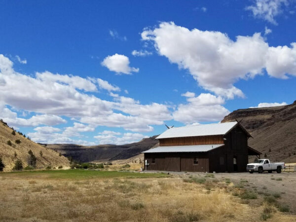
Erickson Aircraft Collection / @ Start & Finish
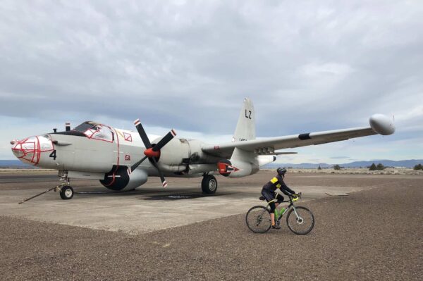
“The Erickson Aircraft Collection is one of the top privately-owned aircraft collections in the world. The Collection was started by Jack Erickson in 1983 and proudly displays vintage aircraft that are still in flying condition such as the P-38 Lightning, P-51 Mustang, Ki43 Hayabusa and B-17 Flying Fortress.” For hours and admissions call (541) 460-5065. [Erickson Aircraft Collection]
Oregon Trunk Railroad / ~ Miles 3.0 - 9.0

In 1908, construction of two competing railroads commenced at the junction of the Deschutes and Columbia Rivers. The Deschutes Railroad, a subsidiary of Union Pacific, was the first to survey and construct along the east bank of the Deschutes River, while the Oregon Trunk Railroad, incorporated by investors from Seattle, began its own surveys and construction along the west bank of the river.
The two railroads faced legal disputes as both competed for access to some of the same ground. The disagreements quickly turned into a railroad war, marked by competing construction crews blowing up each other’s supplies and engaging in gun battles, which resulted in injuries and even deaths. Despite the conflicts, by 1910, the two companies began operating on mostly separate railroads on either side of the river. [The Oregon Trunk and Deschutes Railroads]
For the full history of the railway war, check out “The Deschutes River Railroad War” by Leon Speroff.
Lake Simtustus & Pelton Dam / ~ Miles 9.0 to 11.0
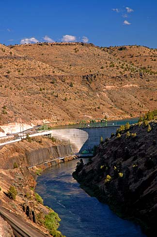
Portland General Electric owns and operates Pelton Dam, a hydroelectric facility on the Deschutes River. This dam was constructed in 1958 and features a concrete arch design. The dam is 204 feet high from the bedrock and has a width of 965 feet at its crest. It generates 110 megawatts of electricity.
Located upstream to the south, Pelton Dam impounds the waters of the Deschutes River, creating the deep Lake Simtustus in a relatively narrow canyon. The lake extends approximately 7 miles upstream to the 1964 Round Butte Dam. [Wikipedia]
Lake Simtustus is named after Pipsher Simtustus (1839-1926), a famed warrior from the Warm Springs tribe who served as a scout for the US army in 1867 and 1868. [Lake Simtustus Resort]
Old Oregon Trunk Railway Tunnel / ~ Mile 17.0
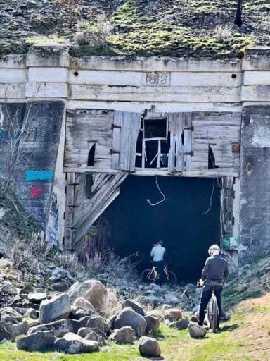
“The Oregon Trunk abandoned its line between South Junction and Metolius in 1923, and began using the Deschutes Railroad track from South Junction into Madras and Bend under a trackage rights agreement. This abandoned section had three tunnels, one of which still exists today and can be easily explored.” The Willow Canyon sector (miles 3 to 9) is part of this abandonment. This is where the old Oregon Trunk Railroad left the Deschutes River and began to head east towards Madras. [The Oregon Trunk and Deschutes Railroads]
Lower Deschutes River / ~ Miles 18.0 to 25.0
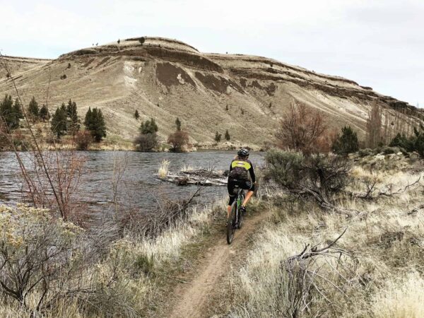
“The Deschutes River begins high in the Cascade Mountains and travels 252-miles north to the Columbia River. The last 100 miles of the river’s path are known as the Lower Deschutes River, which is designated as both a Federal Wild and Scenic River and an Oregon Scenic Waterway.
The Lower Deschutes has a rich cultural history, providing sustenance for thousands of years to the Warm Springs and Wasco people moving seasonally through the area. In the 1800s, due to increasing pressure from settlers, many moved to the lands now known as the Warm Springs Reservation, which borders much of the west side of the Lower Deschutes. Members of the Confederated Tribes of Warm Springs retain their fishing rights and can be seen dip net fishing the traditional way on platforms over the river just below Sherars Falls.” [Recreation.gov]
Trout Creek Ranch / ~ Mile 27.5
“Trout Creek Ranch was first homesteaded in the 1890s, with its primary use being sheep ranching. The property was actively grazed until 1993. [Portland General Electric] purchased the property in 2000 and is currently managing its wildlife and fisheries resources. Completed habitat enhancement projects include flood plain reconnection, rehabilitation of old farmed fields and noxious weed treatments.
Approximately 30% of the summer steelhead run of the Deschutes River system is produced in the Trout Creek Watershed. The ranch and surrounding area are home to mule deer, Rocky Mountain elk, bobcat and cougar. Numerous birds and small mammals also call the ranch home.” [Portland General Electric]
Photo Credit: Portland General Electric
Town of Gateway / ~ Mile 30.0

“Gateway is nine miles north of Madras. It is located in a naturally eroded valley that provides a gate from the Deschutes River to the upper plateau. When railroads first entered Central Oregon from the north along the Deschutes River the Deschutes Railway used this pathway to emerge to the uplands. A post office was established on March 12, 1913. A railroad station and stockyards were built at Gateway and the site became an important shipping point.” [Mecca Grade]
Photo Credit: Mecca Grade
Gateway Grade / ~ Mile 31.0
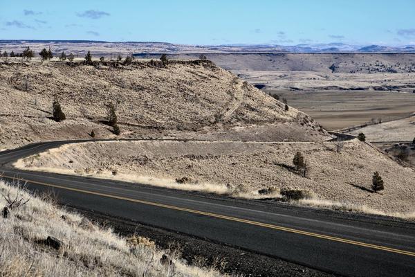
“This road grade is located just west of Gateway and descends down from Agency Plains to Mud Springs Valley. The steep grade was first built to allow Agency Plains farmers a route to get their harvested wheat from the Plains down to the railroad depot at Gateway for shipment to market. It currently is a paved road and the main access from Gateway to Agency Plains.” [Mecca Grade]
Photo Credit: Mecca Grade
Agency Plains / ~ Miles 32.0 to 40.0
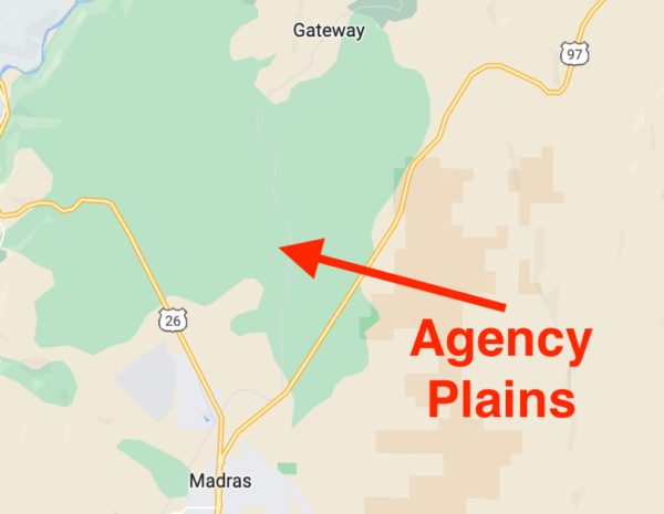
Agency Plains is a plateau just north of the city of Madras. Approximately 250 feet in elevation above the east side of the Deschutes River, the area is within the “Madras Y” (the Y formed by Highway 97 to the east and Highway 26 to the west). The area consists of arable land on which a variety of seed crops are raised, but that was not the case for early settlers who were challenged by dryland farming. Edith Smith, who maintained a family home on the Agency Plains in the early 1900s, recalls: “…there were a lot of flying ants, sage rats and sagebrush to contend with. [We] had to haul water to the homestead as there was no water source nearby.” [The Madras Pioneer]
When We Like to Ride This
The route offers spectacular beauty most of the year. As late summer can be notorious for “Goat Heads,” we recommend riding the route from early-March through late-July. Look for relatively dry conditions; the early March “go date” will depend on winter snows and spring rains.
Terrain & Riding
From the start of the ride at the Erickson Aircraft Collection in Madras, head south for a short bit on paved roads, then meander through double-track gravel that turns into an old railroad grade. (Note: You are one hell of a good cyclist if you make it through the short, crash-inducing rocky bits without playing “hike a bike” or foot dabbing. Over time, this section has gotten easier as it has become more well-traveled.)
Hug the pristine Lake Simtustus shoreline until you reach Highway 26. This is when you sing Over the Rainbow (twice) for a quick two-mile buzz downhill on wide shoulders to the Rainbow Market just outside of Warm Springs.
The next 10 miles are dirt roads, single track, and an old railway grade along the Deschutes River.
Eventually, you end up at Trout Creek campground, where you leave the river and wind up alongside Trout Creek to the main gate for Trout Creek Ranch.
From here, zip through the one-lane tunnel, up a steep 15% grade, recover with a short intermediate respite at Gateway, and then head onto the rim summit via the Gateway grade where you get booming views of the mountains to the west. From here it is a nearly straight line paved route, through farming country, back to the flight museum.
The Start
Erickson Aircraft Collection / Museum. Park in the dirt lot on the north side of the building. Flush toilets and water. There are no parking permits or fees.
Food & Water
- ~ Mile 10: Dockside Cafe & Grill (seasonal)
- ~ Mile 16: Rainbow Market
Route Notes
This route can be notorious for “Goat Heads” (see the When We Like to Ride This block in the “Map & Details” tab). They will stop you in your tracks. Come prepared with tubeless tires topped off with fresh sealant. For a bombproof setup, consider using CushCore gravel inserts.
Note that in the springtime, at mile 2.9 there may be a creek crossing. Usually you can find some rocks to hop without getting your feet wet.
Route Options
Longer
You can add in an additional seven miles of out and back by going out to Trout Creek Ranch (at ~ mile 27.5). Trout Creek Ranch was initially settled in the 1890s and was mainly used for sheep ranching. The property was grazed until 1993. In 2000, Portland General Electric (PGE) acquired the property and began managing the ranch’s wildlife and fisheries resources. PGE has completed several projects to enhance the habitat, such as reconnecting flood plains, rehabilitating old farmed fields, and treating noxious weeds. The Trout Creek Watershed produces about 30% of the Deschutes River system’s summer steelhead run. [Portland General Electric]
Read the signs to determine if access is currently allowed. If so, hop the gate and give it a go. It’s a beautiful ride with rocky gravel.
In Reverse
If it is a windy day, we strongly recommend doing the route in the reverse direction, counterclockwise. Otherwise the last 10 miles will be brutally difficult.
If you do the route in reverse, a couple of notes:
- At mile 22.6 stay right along the river, do not ride pass the blue house. If you have done so, you are going the wrong way.
- In this direction your riding time on Highway 97 will be longer. It starts flat and then climbs 220 feet over 1 mile, a 4% average gradient. Total distance on the highway is ~ 2.5 miles. Use caution. Use a red blinky light.
- Use this GPX file. Do not take the as mapped file and reverse it in Garmin Connect or directly from a Wahoo device. It will not load correctly.
Love Where You Ride! Learn More
 The route starts and ends at the Erickson Aircraft Collection / Museum just to the north of Madras. Consider setting aside an hour before or after your ride to tour the museum, which features over twenty rare aircraft, most of which are still in flying condition.
Videos
The Ride! Over the Rainbow
A quick 2-minute video of what to expect on your ride!
Deschutes Driftwood
A historic (~ 1916) Hollywood video telling the story of a hobo along the tracks of the Deschutes rail line. The video, produced by the American Educational Film Corporation, has excellent scenic footage! (Caution: This film contains insensitive and racial content indicative of the era.)
Keep it Local! Learn More
Ridden and Reviewed by:


 Behind every route is scouting, mapping, storytelling, and a whole lot of pedal power.
Have you ridden this route? Got a question? Join the discussion!