Poke the Bear
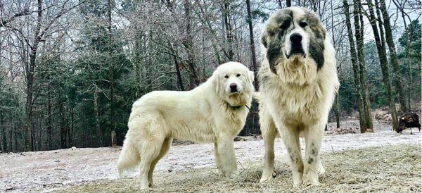
Caution: Livestock guard dogs may be present. Learn how to handle encounters.


Highlights & Remarkable Spots
Hay Creek Ranch / ~ Mile 10.0
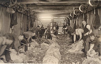
Hay Creek Ranch and its headquarters will be to your right. For over a century, Hay Creek Ranch has been one of the largest ranch holdings in Oregon and has played a prominent role in the history of central Oregon. The ranch was established in 1873 as the Baldwin Sheep and Land Company. The Dalles-Prineville freight and stagecoach lines ran through the ranch headquarters until about 1912. [Oregon Encyclopedia]
Poke the Bear / ~ Mile 31.5
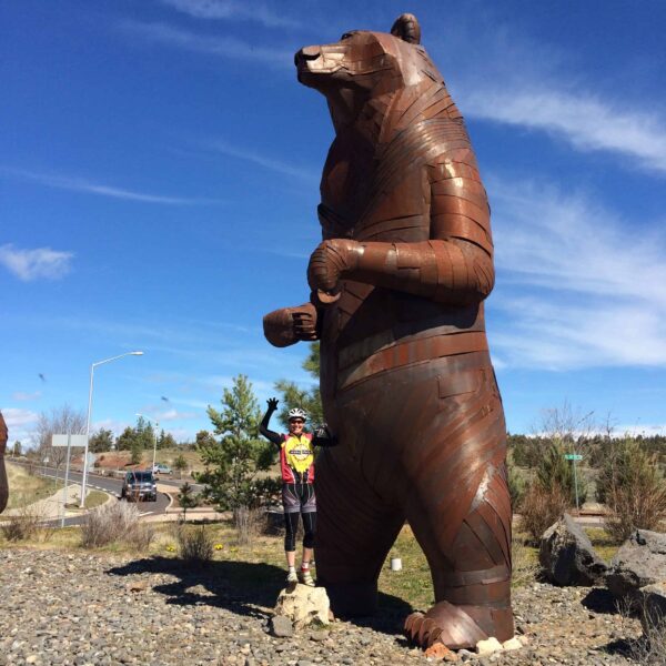
The grizzly bear sculptures in this roundabout were created out of hammered rusted steel by Chris Buffalo Folsom. The sculptures consist of four grizzly bears — a mother and three cubs. The mother bear, who stands on her hind legs, is 27-feet tall. The cubs range in height from 8 to 12 feet, depending on their pose. [The Oregonian]
Listen to the podcast in the sidebar to hear the artist talk about his sculpture.
Red Tail Sculpture / ~ Mile 32.0
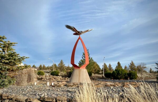
This roundabout sculpture called, “Red Tail,” was created by Eastern Washington resident Miles Pepper, an artist who creates kinetic sculptures for public places. This hawk, which sits above a 25-foot steel sculpture shaped like an arrowhead, has a wingspan of 15 feet. The sculpture is a weather vane, as the hawk’s wings move in the wind. [The Bulletin]
When We Like to Ride This
The best time to ride is in the spring when the creeks flow full and the flowers are in bloom. Or ride on a cool, sunny fall day when the trees are changing colors. Or, on a winter day, when the air is cold, and the ground is frozen. It is best to avoid this route when wet or muddy as the mud can really stick to your bike. Trust us, we have pushed, walked, and carried our bikes through ankle-sucking mud for at least a mile … which felt like an eternity.
Terrain & Riding
The route starts on the northeastern edge of Madras at Juniper Hill Park. The route climbs for the first 1.25 miles on pavement, then dips down just as far. Pick up the gravel and roll up and down through the Baldwin Hills for the next 5 miles.
Catch the sweeping left banking descent that leads down to Hay Creek Ranch, passing by the pastures where Great Pyrenees dogs carefully guard herds of sheep.
After the ranch, you will encounter some punchy hills and then begin a long, gradual climb for the next 8.5 miles. You will pass by the Brewer Reservoir on your left. Just after this, the road becomes a bit more primitive. If it is muddy, turn around! It will not get better, only worse. Trust us!
Just past mile 18, make a hard right onto Grizzly Road, where you will pick up the “Gravel Super Highway.” Once you crest the final gravel kicker, you’ll start to buzz your way back to town with big views. Crest the final gravel kicker for the day, then start to buzz your way back to town.
The Start
Juniper Hills park. Flush toilets. No parking permit or fees required.
Food & Water
- None
Route Notes
Around Mile 10, where the road becomes more primitive, be on the lookout for mud. If you see mud, immediately turn around, as it will get MUCH worse. We can’t emphasize this enough!
Please give a listen to the podcast Tractors, Bulls, and Lycra before giving this ride a go. It is short, about 8 minutes, but important. It discusses rural riding etiquette and what we can do as cyclist to be good visitors.
We recommend a red blinky light with rear looking radar detector, such as a Garmin Varia. This is super helpful on gravel where it is hard to hear cars approaching you from behind.
The route rides great in both directions, some would say better in the opposite direction than what we have mapped. By Dograngerdanger: “Rode on Aug 3 2023. Actually prefer riding this route in reverse (CCW) but amazing views either way you do it!”
You may encounter Livestock Guardian Dogs at the Hay Creek Ranch, at approximately mile 10. Learn how to handle this encounter by reviewing our resource page on Livestock Guardian Dogs.
Love Where You Ride! Learn More
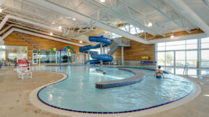 About a mile from Juniper Hills Park, the start of the route, is the Madras Aquatics Center. Known to locals as “The MAC,” the aquatic center is an oasis in the middle of the high Oregon desert. The building itself is stunning, offering panoramic views of the Cascade mountain range through its floor-to-ceiling windows. But what’s even better is a post-ride shower and a soak in a hot tub. After your ride, consider using The MAC’s hot tub and shower. This will cost you a day pass, but it goes to a good cause not only for the community, but for your well-being, too.
Podcasts
The Bear of Steel Sculpture
How do you make a 27 foot tall steel bear for the town of Madras, Oregon? Dial in with Chris Buffalo Fulsom who talks about the inspiration for the mother bear with her three cubs. You’ll find this amazing sculpture on Dirty Freehub’s [...]
Tractors, Bulls and Lycra
In this podcast, we talk with Daarla K who is a rancher and farmer in northeast Oregon. She and her husband operate a 1000-acre farm that has been in his family since 1886. Learn how to safely pass by big tractors and combines, how to get through a cattle drive, and what aggressive behavior [...]
Be Informed!
Keep it Local! Learn More
Ridden and Reviewed by:


Have you ridden this route? Got a question? Join the discussion!