Creek to Peak


Caution! We do not provide turn-by-turn directions in our GPX files. Those are auto-generated by your bike computer and are usually less than 70% accurate. Learn more.
For help loading a GPX file onto your bike computer, go here.
DownloadHighlights & Remarkable Spots
Peter Skene Ogden Trailhead / ~ Mile 3
Peter Skene Ogden was a fur trader and early explorer of the Pacific Northwest. In 1825, he led a contingent of the Hudson’s Bay Company on the first recorded voyage into Central Oregon. He is credited for exploring the Deschutes River, discovering Mt Shasta, and rescuing the survivors of the Whitman Massacre. He is also known for having occasional violent run-ins with the native people, though some view his behaviors as a necessary part of residing in the west at the time.
Island and Pipeline Falls / ~ Miles 5 to 9
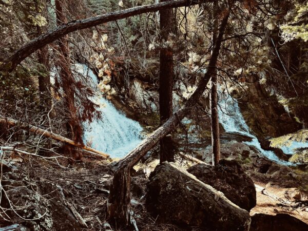
Beginning at the Peter Skene Ogden Trailhead, you’ll follow Paulina Creek to its source at Paulina Lake. There, water from the lake finds drainage at its lowest point, flows down the west side of the Newberry Volcano, and follows the creek until it eventually feeds into the Little Deschutes River. As you pedal, you will come across numerous falls — such as the Island and Pipeline Falls at — that become more dramatic as the canyon walls gain in pitch.
Paulina Lake Lodge / ~ Mile 11
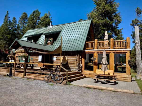
Just a short distance off-route is the Paulina Lake Lodge. The lodge was built in 1929 inside the Newberry Caldera on the shores of Paulina Lake. Offering a general store, a restaurant, and lodging for year-round recreation, the lodge has retained its rustic charm over the years. You may recognize the lodge from the movie “Wild.”
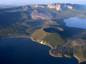
Paulina Lake / ~ Mile 11
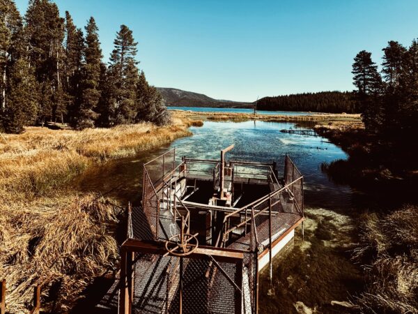
Eruptions at Newberry Volcano began more than 500,000 years ago. Over thousands of years, the eruptions emptied the volcano. Then, about 75,000 years ago, the center of Newberry Volcanco collapsed, creating a caldera. Water collected in the low points, forming two lakes. Paulina Lake, one of the deeper lakes in Oregon, is one of these twin crater lakes situated inside of Newberry Crater. The primary inflow to Paulina Lake is seepage from its twin lake, East Lake, which sits 40 feet higher and one mile to the east. Other sources of water include rain, snowmelt, and a lakeside group of geothermal hot springs that are heated by deep underground magma. The lake was devoid of fish until July 1912, when local citizens stocked both Paulina and East Lakes. The largest brown trout on record in Oregon was caught at Paulina Lake in 2002; the fish weighed 28 lbs, 5 oz. [Wikipedia and Paulina Lake Lodge]
Paulina Peak / ~ Mile 15
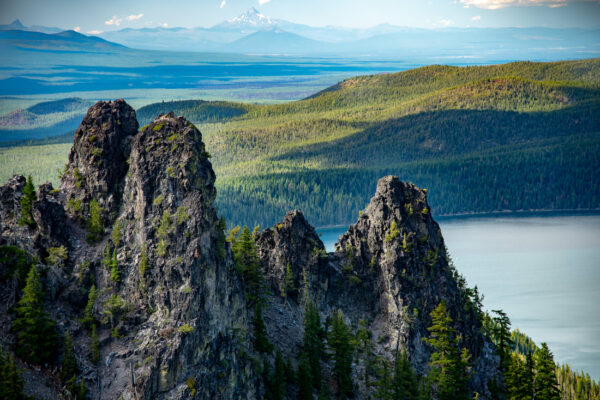
Newberry Volcano is a shield volcano, meaning that it is a broad-domed volcano with gently sloping sides. Paulina Peak (7,984 ft) is the highest point of the volcano. As you ascend, keep your eyes out for the endangered whitebark pine. The tree is important for many reasons, one being that its broad crowns collect and shade snow. This helps pace snowmelt, which in turn helps provide consistent water flow to the area. On a clear day, the peak offers a panoramic view of the Newberry Caldera, the south and west flanks of the Newberry Volcano, and the numerous peaks of the Cascades, including The Sisters, Broken Top, and Mt Hood. [Wikipedia]
Paulina Falls / ~ Mile 20
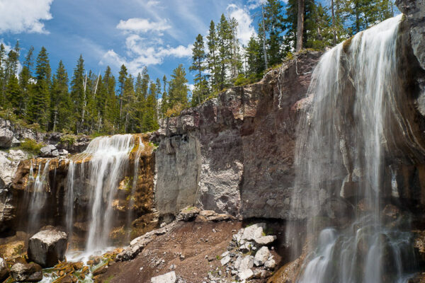
As water drains from Paulina Lake, it cascades 80 feet down Paulina Falls. The double falls are split by a small island that sits at the edge of the volcanic cliffs.
To get to the falls, you will need to stop and make a small excursion into the Paulina Falls Day Use Area. This is just before the real descent (paved) begins. Do it!
When We Like to Ride This
In the late spring / early summer after the snow melts out or early fall after some moisture has made its way back into the ground. The single track section of the route can become loose and dusty and difficult to ride without moisture.
It is best to ride this course on a weekday — not a weekend — as the gravel road to the summit can become busy with cars.
Terrain & Riding
The ride begins with a 2-mile, slightly uphill, paved section. This makes for a nice opportunity to warm up the legs. At ~ 2.5 miles, make a left hand turn onto a gravel road with a sign to Ogden Group camp. Follow the road to the right and look for the Peter Skene Ogden trail sign, about 20 yards off the parking lot. This is a remarkably scenic trail, with little use, that is mostly in the woods and shaded.
Follow the single track, mixed-use trail (hikers, horseback riders, and mountain bikers) for the next 9 miles. This is a mountain bike trail, rideable on a gravel bike, but requires some technical skill through soft sand, around rocks, and over tree roots. It also requires some power and fortitude as it climbs 2100 feet and has short pitches in excess of 10%. As a mountain bike trail, it is of easier+ / moderate- difficulty. Also, the trail is one-way, uphill for bike riders.
The single track follows Paulina Creek for its entirety. About half-way (~ mile 7.7), there is a neat split waterfall. Just before and just after the split falls, the trail is the most technical.
The single track ends at Paulina Lake. Paulina Lake Lodge is just off-route to the left. The route continues to the right on the paved road. Spin out your legs because the climbing is about to begin again very shortly (~0.3 miles).
Make a right turn towards Paulina Peak and begin climbing. The route is paved for just a short bit, then a gravel road leads to the summit. The gravel climb is a steady 8% grade with few breaks for recovery. On the road going uphill, you can find good lines without washboard. Going down, it is more difficult to pick a good line due to speed, thus expect some washboard stutter.
From Paulina Lake back to the parking lot is a paved road descent. Sometimes you can tuck and go. Other times, you will (or can) peddle to keep up speed. Like the start, the last 2.5 miles is flat-ish. Sit up, spin the legs, and cool down.
The Start
There is a paved parking lot at the northeast corner of Highway 97 and Forest Service road 21. There are no services at the parking lot. No parking permit required.
Food & Water
- ~ Mile 11: Paulina Lake Lodge (seasonal; call to verify)
Route Notes
The single track is a multi-use trail. Bikes can only travel uphill. It can be dusty at times and churned up if it has seen horse traffic.
Paulina Peak, the turn around point, is at 8000 feet. Be prepared for significantly cooler temps than at the start.
We have rated this route for effort as 3 out of 5. Yes, it is 32 miles with 3800+ feet of gain, but a better way to think of it is, as 16 miles with 3800+ feet of gain, and 16 miles with 3800+ feet of descent. Also, the course is over 50% paved, but less than 30% of your ride time will be on pavement.
The single-track also has several technical sections with roots, hops, and sharp turns. All but the best technical riders will need to hike-a-bike for few minutes.
Route Options
A shorter option would be to ride the Peter Skene Ogden Trail to Paulina lake and then return down the paved. This takes out the climb to the top of Paulina Peak. 22 miles / 2100 feet of gain.
Love Where You Ride! Learn More
 Check out the Newberry National Volcanic Monument for a look at 500,000 years of Central Oregon history. Spread across the monument’s 57,400 acres are dozens of explosive attractions. Begin with a visit to the Lava Lands Visitor Center for an overview of the area. Then go explore each of the area’s unique features—including the iconic Lava Butte cinder cone, the eerie Lava Cast Forest, the mile-long Lava River Cave, the massive Newberry Caldera, the other-worldly Big Obsidian Flow, and the impressive 80-foot Paulina Falls.
Watch the video below for a fantastic overview of the Newberry National Volcanic Monument.
Videos
The Ride! Creek to Peak
A quick 2-minute video of what to expect on your ride!
The Newberry National Volcanic Monument
This video explains the volcanic history of and science behind the Newberry National Volcanic Monument.
Podcasts
The Mysteries of the Newberry Caldera
Discover the mysteries of the Newberry Caldera and its volcanic activities spanning half a million years. Whether you are riding Creek to Peak or looking for thermals, Ranger Randy and Dr. Daniel McKay of University of [...]
Be Informed!

Keep it Local! Learn More
Ridden and Reviewed by:


 Behind every route is scouting, mapping, storytelling, and a whole lot of pedal power.
Have you ridden this route? Got a question? Join the discussion!