Murderers Creek
Closed: February 1st to April 14th for wildlife migration. More information in the Ride Details tab.


Caution! We do not provide turn-by-turn directions in our GPX files. Those are auto-generated by your bike computer and are usually less than 70% accurate. Learn more.
For help loading a GPX file onto your bike computer, go here.
DownloadHighlights & Remarkable Spots
John Day River / @Start
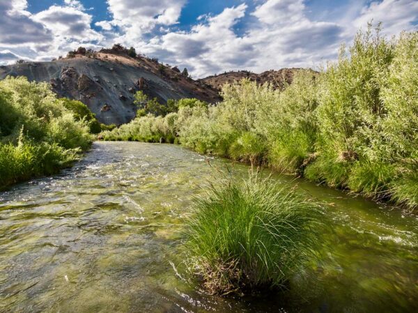
Dayville marks the confluence of the John Day River and the South Fork of the John Day River. The John Day is the longest undammed river in the contiguous United States, flowing freely for 284 miles to its confluence with the Columbia River. This unimpeded flow creates vital spawning and rearing grounds for wild steelhead and Chinook salmon, both of which are listed as threatened under the Endangered Species Act. The absence of dams allows these fish to complete their life cycles without facing migration barriers, a critical factor in maintaining their populations.
2014 South Complex Fire / ~ Miles 10 to 28
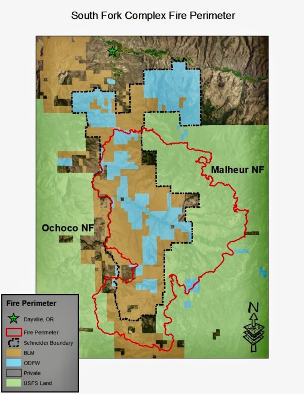
In 2014, the South Fork Complex Fire, a lightning caused wildfire burned more than 65,000 acres of State, Bureau of Land Management, U.S. Forest Service and private property within the South Fork of the John Day River watershed. This stand-replacing wildfire severely altered or removed more than 29,650 acres of remnant sagebrush steppe habitat in critical to mule deer. (Click on map to left for expanded view.)
Phillip W. Schneider Wildlife Area / ~ Miles 4 to 35
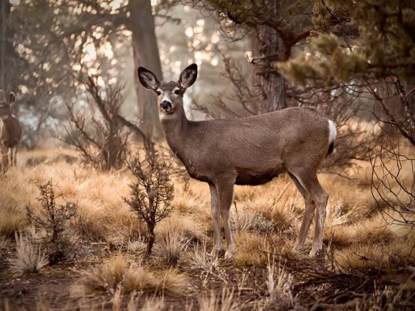
The Phillip W. Schneider Wildlife Area (map) was established in 1972 by the Oregon Department of Fish and Wildlife. Encompassing nearly 52,000 acres along the lower stretch of the South Fork John Day River, its primary objectives are to protect and restore winter range habitat for mule deer and elk. Mule deer populations in Oregon have experienced a significant decline over the past several decades. In 1981, the population peaked at approximately 306,000 individuals. By 2022, estimates indicated a reduction to around 162,600 mule deer, marking a decrease of nearly 47% over 41 years.
Black Canyon Wilderness Area / ~ Mile 12
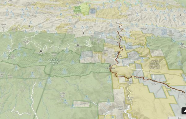
The trailhead to the west leads into the Black Canyon Wilderness, a rugged 13,000-acre area in the Ochoco National Forest. Known for its deep canyons, high ridges, basalt cliffs, and diverse ecosystems, it is protected under the Wilderness Act of 1964 to preserve its natural state. Wilderness areas are free from significant human development, with no roads or permanent structures, and prohibit activities like logging, mining, and motorized vehicle use to maintain ecological integrity and support thriving natural ecosystems. (Click on map to left for expanded view.)
Juniper Reduction Program / ~ Miles 15 to 24
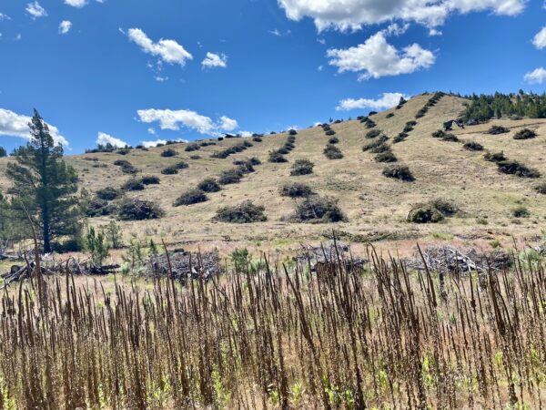
In this area, you may encounter the deliberate removal of western juniper trees as part of a reduction program aimed at restoring soil moisture, increasing water flow, and promoting the recovery of natural grasses. Studies have shown that juniper removal can significantly boost water availability, with some reporting a 225% increase in late-season spring flow. However, there are concerns that cutting juniper may inadvertently encourage the spread of invasive grasses and lead to more juniper saplings growing under felled trees. The ultimate goals are to restore key habitat for species like the greater sage-grouse, mule deer, and other wildlife dependent on the sagebrush steppe. Begin to learn more here.
Murderers Creek Ranch / ~ Mile 19.5
Folklore has it that Murderers Creek received its ominous name from a violent incident in the mid-1800s. One story suggests that a group of 8 prospectors exploring the area for gold encountered members of the Northern Paiute tribe. The confrontation turned deadly, resulting in the death of several prospectors. Another version of the tale claims the violence occurred during a raid by settlers against local Native Americans in retaliation for perceived threats or earlier altercations.
The name, Murderers Creek, serves as a stark reminder of the conflicts and struggles for control over resources and land during Oregon’s settlement era.
Credits & Acknowledgements
This ride guide is funded in part by a grant from Travel Oregon.

When We Like to Ride This
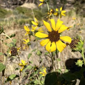
This is a ride that “goes” mid-spring through late fall. In the spring you get the creeks running full, flowers blooming and green fields. But … with the creeks running full you will need to take the high road options along Murderers Creek. In the fall you get the trees changing color and beautiful light.
The Murderers Creek sector of this route [miles 14 to 25] is closed February 1st through April 14th for wildlife migration within the Phillip W. Schneider Wildlife refuge.
Terrain & Riding
It’s all on relatively easy pitches …. There is washboard in the first few miles that quiets down quickly when you reach the national forest just a few miles out of Dayville. Overall, this is gold mine of a route, one that left us grinning for days. (We saw TWO cars on our four hour adventure!)
The views here are colorful, striking, and unique. Basalt outcrops, Ponderosa pine, and Douglas and white fir intermix with juniper, sagebrush, and native bunchgrasses to create a distinct pattern on the rugged canyon slopes.
County Road 42 / Gravel (mostly) / ~ Miles 0 to 9
From the parking area cross the John Day Highway [Hwy 26] and pick up Grant County Road 42 [paved]. The road is lined by farms with hay fields and grazing cattle. Hills pop up to your left and right and the South Fork of the John Day River is to your left. We saw a gang of wild turkeys here.(Micro-video)
“This gravelled Back Country Byway parallels the Wild and Scenic South Fork John Day River through its incised canyon for a distance of 50 miles from its northern terminus at Dayville to the northern border of Malheur National Forest to the south. This drive takes visitors through deep canyons of Columbia River Basalts, through stands of old growth ponderosa pines, Douglas and white fir, and willows that line the road. The river itself contains beautiful rapids and the Izee Falls, which drops 56 feet vertically.
Along the way, you’ll pass the Aldrich Mountain Wilderness Study Area as well as the Black Canyon Wilderness, two areas with ample opportunities for hiking, hunting and wildlife viewing. The Murderer’s Creek area has plentiful wildlife, including deer, elk, black bear, coyotes, bighorn sheep, and upland birds.” [Bureau of Land Management]
At ~ mile 1.5 the road turns to gravel. It is wide, two lanes, with some loose gravel overlay. This sector of the ride probably sees the most traffic due to the ranch houses and thus, is a bit washboarded. With a bit of effort you can usually, not all the time, find a good line.(Micro-video) The road gradually climbs as it is heading up river.
Black Canyon / Gravel / ~ miles 9 to 14
Just after mile 9, the road splits. County Road 42 goes to the right and NF 17 goes left. Go left, climb a short pitch. The road surface changes dramatically. It is now a hard packed brown, clay based road with just a smattering of gravel. No washboard. The riding is fast and scenic.
Soon you enter a box canyon with black rock walls jutting up on both sides of you.(Micro-video) The road twists and turns following the river. At mile 12 is a trailhead leading into Black Canyon Wilderness area.
“A remote 13,400 acre wilderness offering solitude and hillsides dominated by mixed conifer and stands of park-like ponderosa pine. Ridge-tops are predominantly open sagebrush with some mountain mahogany. Deer and elk are common year round. The lucky observer may also see bear, coyote, mountain lion, or possibly wolverines! Beware of rattlesnakes, especially in stream bottoms.” [US Forest Service]
Murderers Creek Basin / Gravel / ~ Miles 14 to 20
At mile 14.5, make a 90 degree left onto a single lane dirt road. The turn is marked by a sign for the Phillip W. Schneider Wildlife Area (Murderers Creek access). Initially the road hugs Murderers Creek and is bounded by steep walls of several hundred feet high.(Micro-video) A fire swept through the area in 2011, as marked by many of the trees being charred black.
“The Phillip W. Schneider Wildlife Area provides winter range for mule deer populations and year-round habitat for elk, deer, and bighorn sheep. Native habitats include sagebrush shrubland, riparian, ponderosa pine forest, western juniper woodland and mixed conifer. The riparian areas along the South Fork John Day River and Murderers Creek provide excellent habitat for many birds.” [Phillip W. Schneider Wildlife Area]
About a mile in, there is junction. The roads re-join is 0.5 miles. The left hand road [the one that climbs] is the safe bet in the spring as it avoids several seasonal creek crossings. The right hand road, is our road of choice in the fall. Just after this first option, there is a second. The same logic applies.
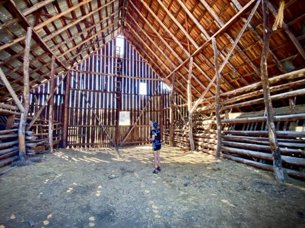
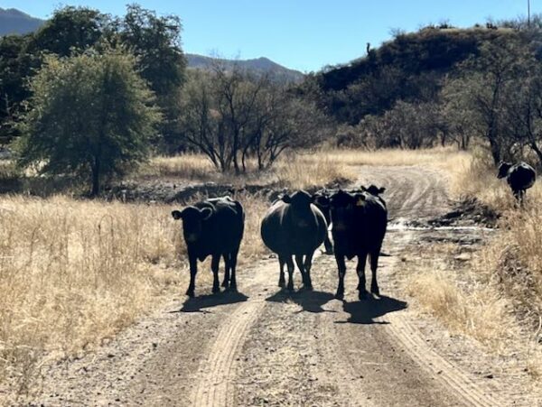
After the roads come together again, the steep looming walls move out and away revealing a large flood plain, Murderers Creek Basin. Trees are scarce and the riding is in the open and exposed … but gorgeous! It is 3 more miles to the Murderers Creek Ranch. As you get close to the ranch, you pass through a gate. Be sure to close it, and keep the cattle in the appropriate grazing areas. [Yes,there are cattle on this ride who may want to share the road with you!(Micro-video) At the ranch, be sure to sure to explore the out buildings. The inside texture and light is special.
Get re-fueled and ready to turn around.
The Return / Gravel (mostly) / ~ Miles 20 to Finish
The ride back out goes like this … lumpy, rock terrain, more than you remember riding in on … the awesome Black Canyon section … and the last 9 miles of scenic county road with some annoying washboard [it really isn’t that bad!].
The Start
Dayville City park. Flush toilets and water. A donation is suggested, we offered up $10. Well worth it!
Alternate Start / All Access
Lat/Long: 44.366660, -119.549470
Just past the intersection of South Fork Road and NF-47 / South Fork John Day Road. Take South Fork Road southwest for 0.25 miles. Just after crossing the South Fork of the John Day river, there will be a turnout to your left back to the river.
Food & Water
- None.
Route Notes
40 mm tires work well for 75% of the ride. For miles 17 to 22 some may prefer 50 mm tires. We did the route on 40 mm and 38 mm tires.
You may encounter cows and open grazing on your ride. Do not whoop and holler to move the cows along! This only increases anxiety in the herd and puts you at more risk. The key things to do are:
- dismount from your bike,
- take of your helmet and sunglasses,
- talk calmly to the herd,
- walk by.
See our resource page for a lot more information on this.
If the fall, this is an active hunting area (bow and rifle). We recommend riding in a hi-viz kit.
This area is likely goathead / puncture vine territory, those thorny things that stick in tires and cause flats. We had no issue with goatheads until we explored beyond the ranch. Our recommendation, keep your bike on the main roads, when you stop keep your bike on the road, not at the side of the road.
Route Options
Shorter / All Access
Start at the 9 mile mark where Grant County 19 and NF 47 split. This will shorten the ride to 21 miles with 950 feet of gain.
Love Where You Ride! Learn More
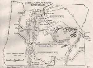 The Dalles Military Road, (click on the map to the right) also known as The Dalles–Boise Military Wagon Road, was a mid-19th-century project intended to connect The Dalles, Oregon, to Fort Boise in Idaho. Constructed between 1868 and 1870 by The Dalles Military Road Company, the endeavor aimed to facilitate military logistics and encourage settlement in the Pacific Northwest. However, the company’s efforts were minimal; they spent approximately $6,000 and received nearly 890 square miles of public land, yet much of the route consisted of pre-existing trails and rudimentary paths. The company’s claims of building a substantial wagon road were significantly exaggerated, leading to public dissatisfaction and legal scrutiny. Despite these issues, the road played a role in the region’s development by providing a transportation link during a pivotal period of westward expansion.
The fraction of the route used by a stage line, that passed through Dayville, that began operation in 1864, is referred to simply as The Dalles – Canyon City Wagon Road in the Dictionary of Oregon History which says “numerous freight wagons, pack trains and tramping feet of miners moving to and from the John Day Valley, gradually hammered it into a fairly good road.” Points along the road included Sherars Bridge, Burnt Ranch, Antone, and Braggs Ranch, in addition to Mitchell and the end points.
Podcasts
Controversial Juniper Trees
The juniper tree is an iconic tree across Central and Eastern Oregon and yet, in some places they are being removed. Find out the real scoop about this unique tree from Gena Goodman-Campbell who is the Stewardship Director at ONDA (Oregon Natural Desert Association) where she works to engage [...]
Be Informed!
Keep it Local! Learn More
Related Guidebooks
-

All Access Gravel Guide Eastern Oregon (Collector’s Edition!)
$12.50Now shipping! A 64-page pocket-sized gravel guide. Featuring gravel routes, art, culture and local history. A one of a kind…Add to cart -

All Access Gravel Guide Western Oregon (Collector’s Edition!)
$12.50Now shipping! A 64-page pocket-sized gravel guide. Featuring gravel routes, art, culture and local history. A one of a kind…Add to cart
Ridden and Reviewed by:


 Behind every route is scouting, mapping, storytelling, and a whole lot of pedal power.
Have you ridden this route? Got a question? Join the discussion!