Ludlum House


Caution! We do not provide turn-by-turn directions in our GPX files. Those are auto-generated by your bike computer and are usually less than 70% accurate. Learn more.
For help loading a GPX file onto your bike computer, go here.
DownloadHighlights & Remarkable Spots
McVay Rock State Recreation Area / Start
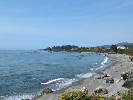
McVay Rock Recreation Area offers stunning 180-degree ocean views, making it a prime spot for whale watching. Each year, gray whales migrate past Curry County on their journey between the warm waters of Baja California and the icy seas of Alaska. Brookings has two peak seasons: October to mid-January, when whales head south to give birth, and mid-January to late April, when they return north to feed on shrimp and krill.
McVay Rock / ~.1 Mile
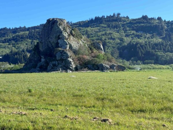
Located near the entrance to McVay Rock State Recreation Area on the eastside of Oceanview Drive is McVay Rock, a remnant of ancient volcanic activity or tectonic uplift that characterizes much of the Oregon coast. Over millions of years, the ocean’s relentless wave action shaped the rock into its current form.
The landmark was named in honor of William R. McVay, who settled in the area in 1861. While detailed records of his contributions are scarce, it is known that his homestead was located nearby.
Harbor Brookings Bench / ~ Miles 0.1 to 1.5

Nestled along the Pacific Coast at the Oregon-California border lies the Easter Lily Capital of the World. It is here that over 95% of the world’s potted Easter Lily bulbs are grown. This unique region, spanning the Harbor-Brookings bench in Oregon and Smith River in California, became a hub for lily cultivation after Louis Houghton introduced hybrid bulbs in 1919. World War II disrupted Japan’s dominance in Easter Lily exports, cutting off U.S. supplies, and local growers stepped in. The region’s ideal climate and rich soils proved perfect for cultivation. Today, ten dedicated farms continue to grow these iconic trumpet-shaped flowers, brightening homes worldwide.
J.P. Wheeler gravesite / ~ Mile 9.5
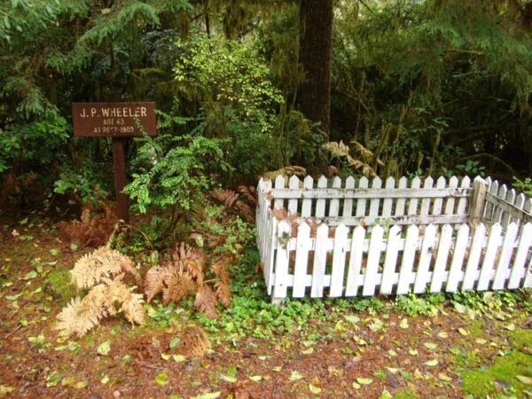
Here lies the gravesite of J.P. Wheeler, one of the first white settlers in the Winchuck Valley. Wheeler passed away in 1903 at the age of 63. His homestead was located several miles northeast of this site, across Wheeler Creek from the present-day Ludlum House. The homestead’s location is now marked by an old apple orchard.
Ludham House / ~ Mile 11.5
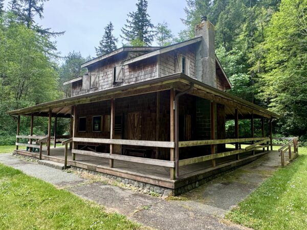
Named after the Ludlum family, who purchased the home and property in 1943, the original Ludlum House is believed to have once been a boarding house in early Brookings before being disassembled and relocated. Peggy Ludlum bought the house and property while her husband, Robert, was serving in World War II as an intelligence officer for General MacArthur and Admiral Nimitz in the Pacific campaign.
In the 1960s, the Forest Service acquired Ludlum House and its property. Due to deterioration, the original structure was replaced in 1999 with a new lodging that remains true to the original design and is available for rent year-round.
Wheeler Creek & Winchuck River / ~ Miles 2.3 to 12.8
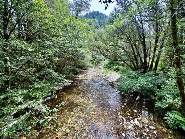
The picturesque Winchuck River winds through the lush landscapes of southern Oregon, carving its path through Curry County and the Rogue River-Siskiyou National Forest. Stretching roughly 21 miles, it meets the Pacific Ocean just south of Brookings, Oregon. Along the way, at mile 12.8 of this ride, the river merges with Wheeler Creek—a pristine tributary renowned for its crystal-clear waters and dense, towering forests. This creek serves as a vital habitat for salmon and trout, while the surrounding riparian zones teem with wildlife. Black-tailed deer, black bears, river otters and eagles all thrive here, making this region a haven for nature lovers and outdoor enthusiasts alike.
Credits & Acknowledgements
This route was funded in part by a grant from the Travel Oregon.

When We Like to Ride This
Options:
- Late spring when the rhododendrons are in bloom and the creeks are flowing.
- Fall with all its vibrant colors.
- Early summer mornings when coastal fog lifts and sunlight streams through the tree canopy. However, be prepared for increased tourist traffic then.
This ride can be enjoyed nearly year-round. Look for a sunny day with light coastal winds.
Terrain & Riding
Overall, this ride is slightly more demanding than the elevation profile would indicate.
Harbor Brookings Bench Sector / Mile 0 to 1.6
This sector is flat and on smooth pavement. The road does not have a shoulder but when we rode it there was very little traffic. This sector is filled with farm fields and frequent coastal views.
Winchuck Road Sector / Miles 1.6 to 9.9
Similar to the first sector, Winchuck Road has good pavement, no shoulder and light traffic. This entire sector is rolling with little climbs and descents, all the while gaining slightly in elevation. You will have frequent views of the Winchuck River to the right as you ride past farm pastures and into the woodlands.
Rogue River-Siskiyou National Forest Sector / Miles 9.9 to 12.8
Turn left and begin a short climb—the steepest of the ride—with the gradient exceeding 6%. The road starts out paved but transitions to gravel/dirt in 0.4 miles. The gravel is hard-packed but potholed. There is a brief 0.1-mile paved stretch at mile 11.
Beyond the Ludlum House, the road becomes rougher, we recommend 45mm tires or wider. This section, from the Ludlum house out to the second bridge, is a favorite part of the ride for us. It showcases moss-covered trees and ferns thickly blanketing the ground.
This entire sector is within the Rogue River-Siskiyou National Forest. You’ll encounter Douglas fir, red alder, cedar, and deciduous trees like bigleaf maples and white and black oaks. The forest features a mix of mid-growth and old-growth trees.
The Start
McVay Rock State Recreation Site. Pit toilets. Also has a small path to the beach with great views!
Food & Water
- None
Route Notes
Winchuck road is an access road to the Rogue River-Siskiyou National Forest. As with all rides in the Coast Range Mountains, you should expect logging truck traffic. However, we have ridden this route several times and did not encounter any logging trucks.
A couple of things to keep in mind:
- Hauling log trucks always have the right of way!
- Move to side of road. Stop, put a foot down. Wave!
- Use lights. A flashing white front light and a red flashing rear light.
- Do not override your sight lines.
- Keep your group size small and together; reducing your riding footprint.
- Listen and be observant.
We recommend a red blinky light with a rear-looking radar detector for this ride. Something like a Garmin Varia or Trek Car Back.
Route Options
Shorter
The route can be shortened by about 2.5 miles and 150 feet of gain by making the Ludlum House the turn-around point.
Love Where You Ride! Learn More
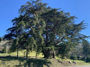 Did you know that the Chetco Valley is home to the largest Monterey cypress in Oregon? Just a mile north on Highway 101, at the Chetco Valley Museum, this towering giant has stood since the 1850s, planted by early settler Harrison G. Blake. While Monterey cypress trees are native to California’s central coast, this one has flourished for over a century, growing into a record-breaking landmark and now listed as an Oregon Heritage Tree.
But the tree isn’t the only piece of history here—the museum itself is a treasure. The museum is housed in the historic Blake House, built in 1857 and recognized as the oldest standing residence in the Chetco Valley. Once a stagecoach stop and trading post, the Blake House sits atop a hill overlooking the Chetco Valley and Pacific Ocean.
Listen to our podcast (below) and discover the stories rooted in Oregon’s landscape.
Podcasts
Monterey Cypress
In this podcast, we dive deep into the history of the Monterey Cypress with Nancy Appling Salucci of the Heritage Tree Committee and Beth Dehn of Oregon Travel Information Council. What makes this unique tree so special, and why did it stand out in a world of towering giants? We explore its [...]
Keep it Local! Learn More

Related Guidebooks
-

All Access Gravel Guide Eastern Oregon (Collector’s Edition!)
$12.50Now shipping! A 64-page pocket-sized gravel guide. Featuring gravel routes, art, culture and local history. A one of a kind…Add to cart -

All Access Gravel Guide Western Oregon (Collector’s Edition!)
$12.50Now shipping! A 64-page pocket-sized gravel guide. Featuring gravel routes, art, culture and local history. A one of a kind…Add to cart
Ridden and Reviewed by:


 Behind every route is scouting, mapping, storytelling, and a whole lot of pedal power.
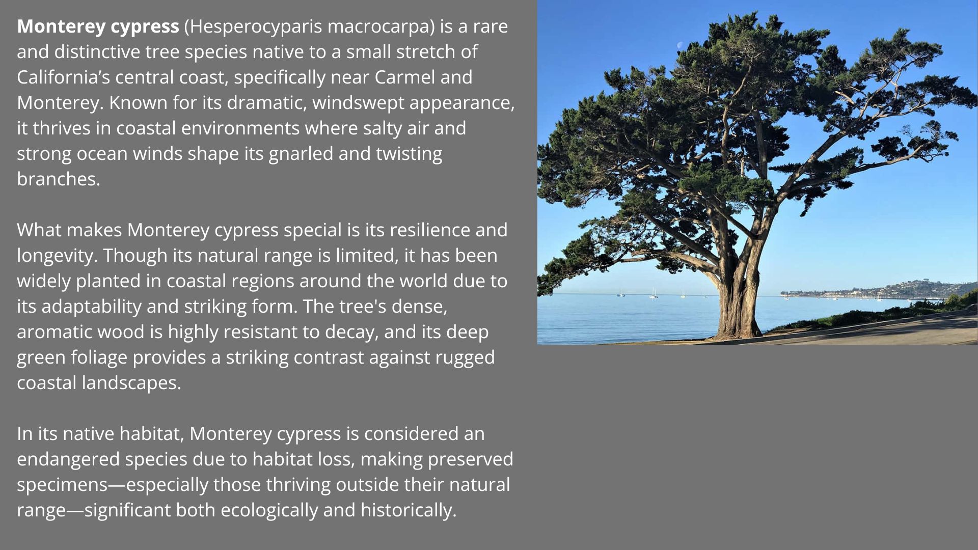
Have you ridden this route? Got a question? Join the discussion!