Lost Wagon Train


Caution! We do not provide turn-by-turn directions in our GPX files. Those are auto-generated by your bike computer and are usually less than 70% accurate. Learn more.
For help loading a GPX file onto your bike computer, go here.
DownloadHighlights & Remarkable Spots
Crooked River National Grasslands / ~ Mile 0.5 - 6.0
Homesteaders first settled the area in the 1880s, constructing more than 700 homes. By the 1930s, insufficient rainfall and unfavorable economic conditions led to farm failures and land abandonment. By 1935, about 35% of the homesteads were foreclosed upon by federal and private mortgage banks. The government repurchased the land from the remaining homesteaders. The Crooked River National Grassland was created by Congress in 1960 to improve range management and the forage resource. The grasslands, which cover 173,629 acres, include two National Wild and Scenic Rivers: the Deschutes and the Crooked. There are 20 national grasslands across the country, but Crooked River National Grassland is the only national grassland in the Pacific Northwest. [Ochoco National Forest]
Richardson's Rock Ranch / ~ Mile 17.0
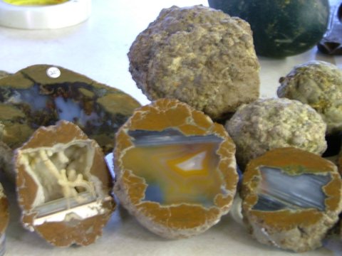
Richardson’s Rock Ranch is well known by rock hounds all across the globe. The shop sells an impressive collection of rough and finished stones — including fossils, geodes, and polished spheres — from all over the world, including Morocco, Madagascar, Brazil, India, China, Indonesia, Africa and beyond. The shop used to allow customers to dig in the Kennedy and Priday agate beds, but digging was permanently closed in 2019. The shop still digs for and sells thundereggs, the Oregon state rock. These are gorgeous nodule-like, agate-filled rocks formed within rhyolitic volcanic ash layers. [Richardson Rock Ranch]
Photo Credit: Richardson Rock Ranch
Agency Plains / ~ Miles 20.0 - 35.0
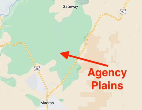
Agency Plains is a plateau just north of the city of Madras. Approximately 250 feet in elevation above the east side of the Deschutes River, the area is within the “Madras Y” (the Y formed by Highway 97 to the east and Highway 26 to the west). The area consists of arable land on which a variety of seed crops are raised, but that was not the case for early settlers who were challenged by dryland farming. Edith Smith, who maintained a family home on the Agency Plains in the early 1900s, recalls: “…there were a lot of flying ants, sage rats and sagebrush to contend with. [We] had to haul water to the homestead as there was no water source nearby.” [The Madras Pioneer]
Meek's Wagon Train Tragedy / ~ Mile 24.0
Meek’s Wagon Train tragedy refers to an incident that occurred in 1845 during the westward migration on the Oregon Trail. Stephen Meek, a mountain man and guide, led a group of 200 emigrants on an alternate route to the established Oregon Trail. The group faced multiple obstacles, including a lack of water and difficult terrain, which resulted in the loss of many oxen and horses.
As the group became increasingly desperate, Meek convinced them to abandon their wagons and attempt to cross the Cascade Mountains on foot. The journey was treacherous, and the group suffered from starvation, hypothermia, and exposure. By the time they reached the Willamette Valley, only 48 of the original party survived. This tragedy is considered one of the deadliest incidents on the Oregon Trail and is often cited as an example of the dangers of traveling westward in the mid-19th century. [Wikipedia]
Town of Gateway / ~ Mile 26.0

The town of Gateway earned its name because it is located in a naturally eroded valley where a depression in the terrain provides a natural gateway from the Deschutes River to the upper plateau. When railroads first entered into Oregon from the north along the Deschutes River, one of the rail lines used this pathway to emerge to the uplands. The presence of the railroad helped grow the Gateway community into one that could support a school, a church, a railroad depot, and a store. Many of the settlers’ ancestors still live in the area today, but the community is no longer the thriving metropolis it once was. [Mecca Grade]
Photo Credit: Mecca Grade
Lake Simtustus & Pelton Dam / ~ Miles 42.0 - 45.5
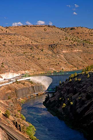
Portland General Electric owns and operates Pelton Dam, a hydroelectric facility on the Deschutes River. This dam was constructed in 1958 and features a concrete arch design. The dam is 204 feet high from the bedrock and has a width of 965 feet at its crest. It generates 110 megawatts of electricity.
Located upstream to the south, Pelton Dam impounds the waters of the Deschutes River, creating the deep Lake Simtustus in a relatively narrow canyon. The lake extends approximately 7 miles upstream to the 1964 Round Butte Dam. [Wikipedia]
Lake Simtustus is named after Pipsher Simtustus (1839-1926), a famed warrior from the Warm Springs tribe who served as a scout for the US army in 1867 and 1868. [Lake Simtustus Resort]
Bear Sculpture / ~ Mile 56.5
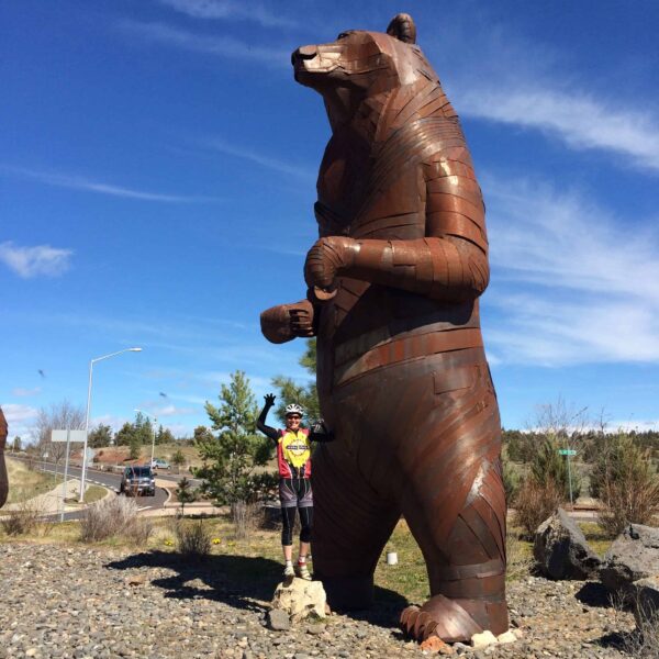
The grizzly bear sculptures in this roundabout were created out of hammered rusted steel by Chris Buffalo Folsom. The sculptures consist of four grizzly bears — a mother and three cubs. The mother bear, who stands on her hind legs, is 27-feet tall. The cubs range in height from 8 to 12 feet, depending on their pose. [The Oregonian]
Listen to the podcast in the sidebar to hear the artist talk about his sculpture.
Red Tail Sculpture / ~ Mile 57.0
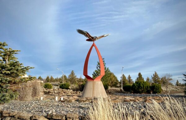
This roundabout sculpture called, “Red Tail,” was created by Eastern Washington resident Miles Pepper, an artist who creates kinetic sculptures for public places. This hawk, which sits above a 25-foot steel sculpture shaped like an arrowhead, has a wingspan of 15 feet. The sculpture is a weather vane, as the hawk’s wings move in the wind. [The Bulletin]
When We Like to Ride This
In the spring when the fields are green and the grassland flowers are in bloom. The route rides well most of the year, even in the winter. Look for times when the snow levels are high and the desert is dry. On hot summer days or windy days, avoid this route as it is too exposed.
Terrain & Riding
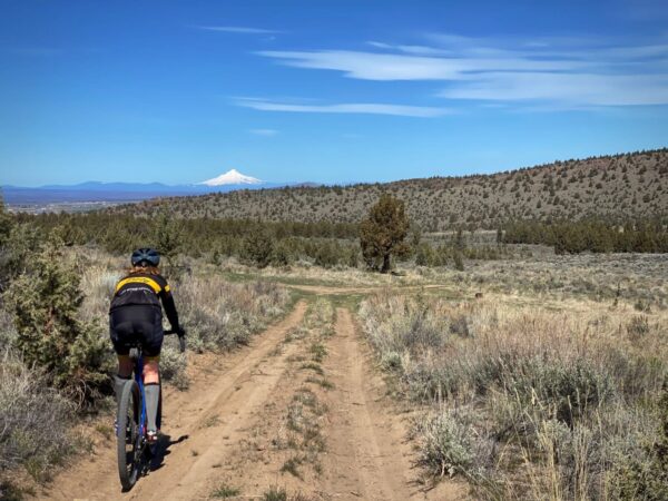
The route starts at the Madras Aquatic Center. After leaving the aquatic center, you’ll roll on pavement for a couple of miles. Then a quick, speedy downhill will deliver you into a long, 15-mile stretch of gravel. The riding is through the scenic Baldwin Hills and skirts the National Grasslands. It is up and down (more down than up), with some technical bits.
At ~ mile 26, make a left on the edge of the farming community of Gateway and then climb one of the Gateway grades, a hill of less than a mile at 5% gradient. From here it is relatively flat for the next 11 miles with the exception of one bump at mile 31. This is your chance to spin and rejuvenate your legs. The crux of the ride is yet to come.
The sign for Barry Ranches (Herefords & Angus) marks the end of the farming flats. Get ready for a moderately steep gravel descent with a couple of big sweeping S-turns with great photo opportunities. As you bottom out, the road becomes more narrow and passes between a set of buildings and a house. It will feel almost as though you are on a private drive to a home. You are not! You are on a public road. (Just in case somebody stops you, consider showing them the attached photo that shows the road as a public right away.)
Soon, the gravel ends with a left-hand turn onto Pelton Dam road. Enjoy the short, winding section along Lake Simtustus as you are about to be smacked by the crux of your ride day. Fourty-five miles into the ride, you’ll encounter a steep, short kicker hill, the Pelton Hill Climb. The climb is 1.3 miles-long with an average gradient of 11% and a long false flat climb to the junction with Belmont Lane.
From there it is more downhill than up, with a drop through Dry Canyon as you head west to east through Madras.
The Start
Madras Aquatic Center. Flush toilets. Water. No parking permit or fee required.
Food & Water
- ~ Mile 0.0 / Madras Aquatic Center (when open)
Route Notes
The route starts at the Madras Aquatic Center. Let the front desk know you are doing a Dirty Freehub gravel bike route and they will usually allow you access to the locker rooms without a fee. After the ride, consider using the hot tub and taking a shower. This will cost you a day pass, but it’s well worth it.
Some of the roads see little traffic and little upkeep. The route is suitable for a road bike, but much more fun and comfortable on a gravel bike.
Even though the route is more pavement than gravel, larger width tubeless tires are a must for this route as punctures and sidewall cuts can happen. 40 mm tires work great. 35 mm is doable with good bike handling skills.
Love Where You Ride! Learn More
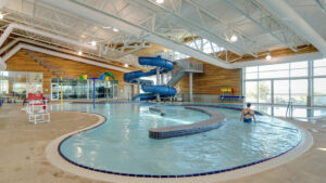 The Madras Aquatics Center, known to locals as “The MAC,” is an oasis in the middle of the high Oregon desert. The building itself is stunning, offering panoramic views of the Cascade mountain range through its floor-to-ceiling windows. But what’s even better is a post-ride shower and a soak in a hot tub. The Lost Wagon Train begins and ends at The MAC. After your ride, consider using The MAC’s hot tub and shower. This will cost you a day pass, but it goes to a good cause not only for the community, but for your well-being, too.
Podcasts
The Bear of Steel Sculpture
How do you make a 27 foot tall steel bear for the town of Madras, Oregon? Dial in with Chris Buffalo Fulsom who talks about the inspiration for the mother bear with her three cubs. You’ll find this amazing sculpture on Dirty Freehub’s [...]
Keep it Local! Learn More
Ridden and Reviewed by:


 Behind every route is scouting, mapping, storytelling, and a whole lot of pedal power.
Have you ridden this route? Got a question? Join the discussion!