Klamath Marsh


Caution! We do not provide turn-by-turn directions in our GPX files. Those are auto-generated by your bike computer and are usually less than 70% accurate. Learn more.
For help loading a GPX file onto your bike computer, go here.
DownloadHighlights & Remarkable Spots
The Stick (going south) / Dirt Road / ~ Miles 0 to 7
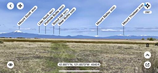
From the parking area, head south on the dirt road. The first 2.5 miles are jaw-dropping gorgeous. Open views of the Klamath March are backdropped by the Cascade Mountains. From south to north, the dominant peaks are Mt McLoughlin, Mt Scott, Mt Bailey, and Mt Thielsen. Each of these mountains is 8000+ feet.
Just after mile 4, there is a signed turnout to a canoe launch. Take this turn. It will bring you to the edge of the water and with some more fantastic views.
Miles 4 to 7 hug the marshland, but the dirt road is just deep enough in the woods that the views are very limited.
This entire sector is a one-lane dirt road that we would classify as primitive but not technically demanding.
Wocus Loop / Gravel & Dirt Roads / ~ Miles 17 to 19
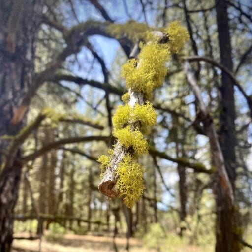
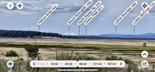
The next 12 miles loop around Wocus Butte in a counter-clockwise direction with the Klamath Marsh to the outside. You dance along on small roads darting out to the marsh and back into the forest. At times it almost feels like you are riding a flowy mountain bike trail — but this is all double-track or dirt road. The Ponderosa trees are red and tall. Green wolf moss hangs downs from the limbs of trees.
The Stick (going north) / Dirt Road / ~ Miles 19 to Finish
The next 7 miles are the reverse of the first 7 miles. It starts with a pedal free descent on a wide red cinder road, then a left turn back onto NF 690. Wooded at first and then an explosion of views (again!) — wetlands backdropped by the Cascade Mountains.
When We Like to Ride This
May through June when the marsh is full of water, and the grasses are green. Birding season is from February through June.
Terrain & Riding
“The Klamath Marsh National Wildlife Refuge was established in 1958 ‘… as an inviolate sanctuary … for migratory birds.’ The refuge primarily consists of 40,000 acres of wet meadows and open water wetlands. With a backdrop of the Cascade Mountain Range, this large natural marsh encompasses the upper reaches of the Williamson River. It provides important nesting, feeding, and staging habitat for waterfowl and sandhill cranes. The refuge also appears to be one of the last remaining strongholds of the spotted frog, a candidate for the endangered species list. This refuge, along with the 15,000 acres of wetlands on the nearby Upper Klamath Refuge, has a rich cultural heritage. It includes part of the historic lands and former reservation used by the Klamath tribes.” [US Fish & Wildlife Service]
A couple of notes before you begin the ride: please stay on route and respect any seasonal closures the Fish and Wildlife Service and / or the Forest Service put in place for wildlife nesting or deer/elk calving/overwintering. This is also an important area for The Klamath Tribes; please do not disturb any artifacts. And lastly, if you see any illegal activity, please report it promptly to the local Sheriff’s office.
The Start
A makeshift dirt pull-out at the intersection of Silver Lake Road (Highway 676) and NF 690.
Food & Water
- None.
Route Notes
The RideWithGPS elevation profile is a bit misleading. It looks as if the route is jagged with steep ups and downs; it is not! Remember, for the 26 miles; there is only 1000 feet of gain. The ride has one significant hill of about a mile in length with an average gradient of 4%.
Most of the roads along this route are dirt roads, not proper gravel roads, thus our recommendation for 45 mm tires or larger. Later in the season, these roads will become sandier and a 50 mm tire may be a better choice.
Get Involved!
![]() To learn more about the Klamath basin and the associated wetlands we would encourage you to check out Oregon Wild. Oregon Wild works to protect and restore Oregon wildlands, wildlife, and waters as an enduring legacy for future generations.
To learn more about the Klamath basin and the associated wetlands we would encourage you to check out Oregon Wild. Oregon Wild works to protect and restore Oregon wildlands, wildlife, and waters as an enduring legacy for future generations.
Videos
The Ride! Klamath Marsh
A quick 2-minute video of what to expect on your ride!
Birds of the Klamath Basin
Ridden and Reviewed by:


 Behind every route is scouting, mapping, storytelling, and a whole lot of pedal power.
Have you ridden this route? Got a question? Join the discussion!