Keating with Love & Virtue!


Highlights & Remarkable Spots
Virtue Mine District / Mile 1 to 5
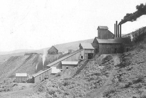
In this area, there were a number of gold & silver mines in the late 1800s and early 1900s including the Flagstaff, Virtue, and Friday mines. The Virtue mine reached 1000 feet deep and a length of 10,000 feet. The total production from the mine is estimated at $2,189,000. In the year 1897 the yield of gold from 313 gold mines and claims in the area, in all stages of development, was estimated at $3,000,000. [Western Mining History]
James W. Virtue
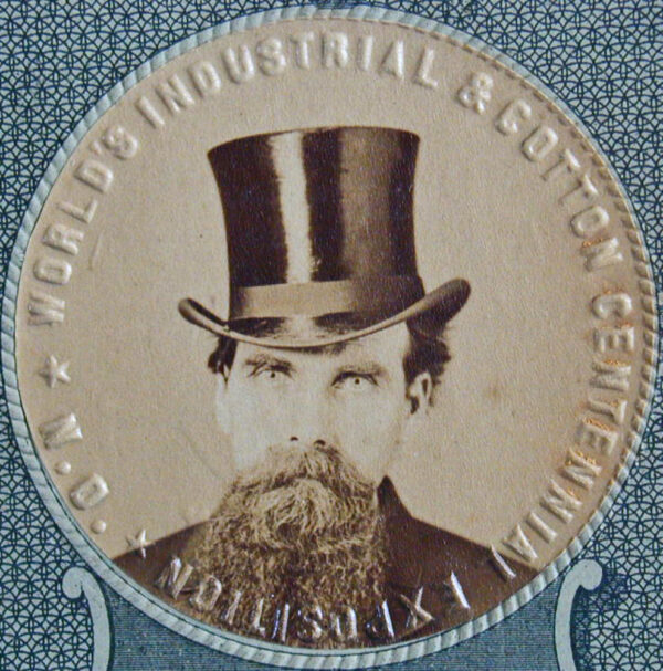
“As early as 1871, James William Virtue—one-time sheriff of Baker County—was recognized nationally for his expertise as a miner when President Ulysses S. Grant appointed him U.S. centennial commissioner. His charge was to help plan “an international exhibition of arts, manufactures, and products of the soil and mine,” to be held in Philadelphia in 1876 as part of the centennial celebration of American independence.At one time, Virtue was considered the richest man in eastern Oregon, but he suffered financial disaster when his bank failed during the Panic of 1893.” [Oregon Encyclopedia]
Wallowa Mountains / ~ Mile 8
The Wallowa Mountains are known as the “Alps of Oregon”. They are composed of metamorphic rock and granitic rocks of the Wallowa Batholith. The Batholith formed when huge blobs of magma were injected into the rocks of the exotic terranes about 130 million years ago. Because the magma was injected many miles below the surface, the molten rock cooled slowly, allowing the characteristic coarse salt and pepper crystal texture of granite to form. However, the hills around the valleys surrounding the high-Wallowas are made up of Columbia River Basalt. [Cycle Oregon]
Keating / ~ Mile 14
Keating and the Keating Valley are home to productive farms and ranches today. The “town” is named for “Uncle Tom” Keating, a former British sailor and early settler and investor in land. A post office opened December 1880 and remained active until January 1975. In 1870 there was an attempt to alter the course of the Oregon Trail by leaving the traditional route near Durkee and cutting across the hills to the Lower Powder River valley (near Keating) and thence to Pondosa and Telocaset. (If you have know of more historical information, please drop us a note.) [Wikipedia]
Widman Hunting Preserve / ~ mile 30
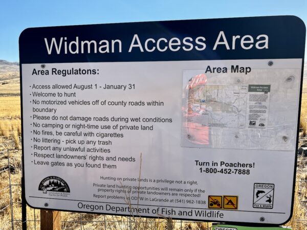
The Widman Access Area is a cooperative program between a private landowner and the Oregon Department of Fish & Wildlife. The goal is to maintain public hunting access on private lands and increase access to public land. The lands provide habitat for deer, elk, pronghorn antelope, Hungarian partridge, chukar, and quail. The ranch has also been active in habitat improvement projects aimed at treating invasive annual grass and re-establishing perennial grass. [on-site kiosk]
Love Reservoir / ~ Mile 32
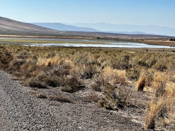
Walter S. Love’s sons homesteaded land between Kelley Creek and Ritter Creek. He built the Love Reservoir around 1900 to furnish irrigation water for this land. This reservoir was fed by ditches that brought water from Love, and Ritter Creeks. When full, it covered 120 acres, but now with the higher dam, it covers 160 acres. [Baker County Oregon Geneology and History]
When We Like to Ride This
Spring and Fall, when temps are more moderate. Very exposed. When windy and hot, no go! If do this in the summer pick a “cooler” day or get an early start. In the spring and fall, the afternoon light is just gorgeous.
Terrain & Riding
The roads. A mix of maintained gravel county roads (with a little pavement) and dirt BLM roads. The terrain. Farm and ranch lands. Rolling hills. Valleys and distant mountain ranges. Grasslands and sage.
Sector 1 / Stick of Lollipop / Virtue Flats & Ruckles Creek / Miles 0 to 10
Downhill at 1 to 2%, hard-packed, double lane road, some washboard. Hunt for a smooth line. Rolling hills, grasslands, Ruckles Creek and a small canyon.
Sector 2 / Keating / Miles 10 to 24
This is what we call the north loop. From the highway to Keating back to the highway. Rolling hills through farming and ranch country.
Sector 3 / Widman Ranch & Love Reservoir / Miles 24 to 38
Rugged, exposed (the most demanding terrain of the day). Views that go on for miles and miles. With the longest climb of the day (4 miles, 900 feet, average gradient of ~ 4%). Expect some loose river rock and river rock cobblestone.
Sector 4 / Stick of Lollipop / Virtue Flats & Ruckles Creek / Miles 38 to Finish
The reverse of sector 1. Surprisingly, this sector is not as demanding as one would expect. A 1 to 2% uphill grade, with the steepest climbing being back up to the Oregon Trail Interpretive Center.
The Start
Oregon Trail Interpretive Center. Paved parking lot. Water. Flush toilets.
Food & Water
- None
Route Notes
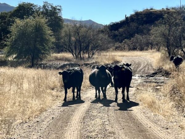
Please ride with respect! Portions of this ride are through rural working ranch and farming country. Please give way to trucks, tractors, and combines. That may mean stopping as a group and letting a large combine pass, or it may be as simple as riding in a tight single file line when an oncoming truck with trailing is approaching. To help alert you to traffic from behind, we recommend a rear-looking radar detector like a Garmin Varia. Also, give a listen to our podcast with a local rancher who talks about the challenges cyclists create for them and how we can be better visitors.
Route Options
There is a shorter and longer option. The shorter option, Keating with Love, starts at the alternative parking area, just off Highway 86, at mile 11 of this route. This option is a loop of 30 miles with 1800 feet of gain.
The longer option is the “Rough & Rowdy (GPX File)” version. It tackles a segment of dirt road that is more primitive and demanding, starting at mile 25. 58 miles and 4000 feet of gain. Go prepared!
Love Where You Ride! Learn More
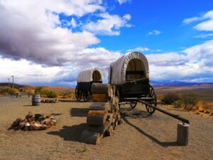 If you have any feel for history whatsoever, the Oregon Trail Interpretive Center is well worth an hour of your time (located at the start of the ride). Situated on a hill overlooking the historic Oregon Trail, there is just something about it. The models of wagons, carts, mules, horses, buffalos and coyotes are so realistic. The Center tells the story of Oregon Trail pioneers, explorers, miners and settlers of the frontier west. The 500-acre site includes remnants of the historic Flagstaff Gold Mine, actual ruts carved by pioneer wagons, and magnificent vistas of the historic trail route.
Videos
The Ride! Keating with Love & Virtue
A quick 2-minute video of what to expect on your ride!
Life on the Oregon Trail
What was life really like on the Oregon Trail? Learn about the risks and dangers of being on the trail, what a day in the life of a pioneer was like, and what equipment and supplies were used. This video is really worth 14 minutes of your time!
Podcasts
Tractors, Bulls and Lycra
In this podcast, we talk with Daarla K who is a rancher and farmer in northeast Oregon. She and her husband operate a 1000-acre farm that has been in his family since 1886. Learn how to safely pass by big tractors and combines, how to get through a cattle drive, and what aggressive behavior [...]
Be Informed!
Keep it Local! Learn More
Ridden and Reviewed by:


Have you ridden this route? Got a question? Join the discussion!