Honeyman
Caution: There is a landslip at ~ mile 41. We have noted this in Ride Details tab. Also, see the Comments.


Caution! We do not provide turn-by-turn directions in our GPX files. Those are auto-generated by your bike computer and are usually less than 70% accurate. Learn more.
For help loading a GPX file onto your bike computer, go here.
DownloadHighlights & Remarkable Spots
Woahink and Siltcoos Lakes / ~ Mile 2 & Miles 10 to 15
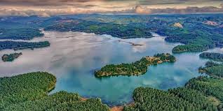
Woahink and Siltcoos lake are ancient parts of what used to be the Siltcoos River delta, dating back to before the Last Glacial Maximum, which occurred between 20,000 and 26,000 years ago. These lakes were created as a result of the glaciers melting, which led to a rise in sea levels. This rise in sea levels submerged the lower parts of coastal rivers, preventing them from carrying away sediments from the Coast Mountains. Consequently, sand dunes were formed by the actions of wind, currents, tides, and waves. These dunes obstructed the original outlets of rivers and creeks. Lakes, including Woahink and Siltcoos, eventually formed behind these dunes.
Lane Line of SP Railroad / ~ Miles 5 to 15
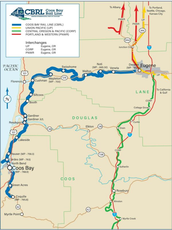
This marks the first occurance of the historic Lane Line of the SP Railroad. The Line runs from Eugene to Coquille (just past Coos Bay).
From 1914 to the mid 1960’s the line hauled lumber out of the area and visitors into the area. Events on the trains sponsored by the Independent Order of Odd Fellows were weekly occurrences. Dances in Siltcoos Hall during the winter months maintained a steady flow of people from the Willamette Valley.
The Port of Coos Bay reopened the line in 2011. Today the Coos Bay Rail Line transports approximately $460 million worth of freight in and out of the region per year. About 89% of the product moved on the rail line is related to the timber industry.
Siltcoos Station / ~ Mile 11
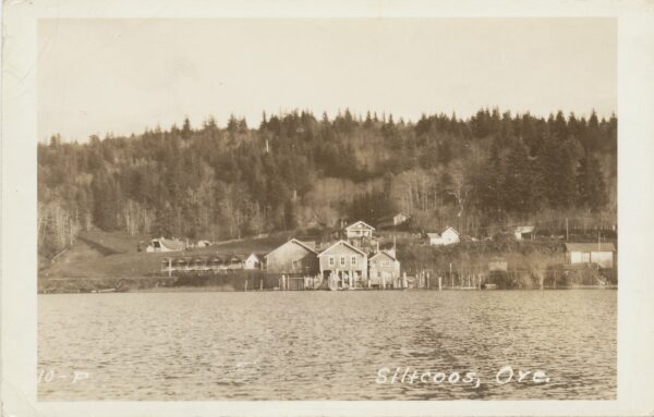
Danish immigrant, Neal Christensen, homesteaded the area known as Siltcoos in 1892, settling under the National Timber and Stone Act. He and his sons built docks and piers to enable the shipment of supplies to build the Lane line of the SP Railroad. They created a ferry system of barges between neighboring lakes that connected the roadway to the railroad construction area. The areas between the lakes were connected via stagecoaches and small gauge rails. In 1914, the rail was completed including a railroad switch and stop in front of what became Siltcoos Station. As a result of the rail, lumber mills and fishing resorts started to flourish and the lake population grew. The stagecoach road built by Christensen that connected part of the road between Woahink lake and Siltcoos lake became known as Siltcoos Station Road.
SP Railroad Bridge Views / ~ Miles 12 to 14
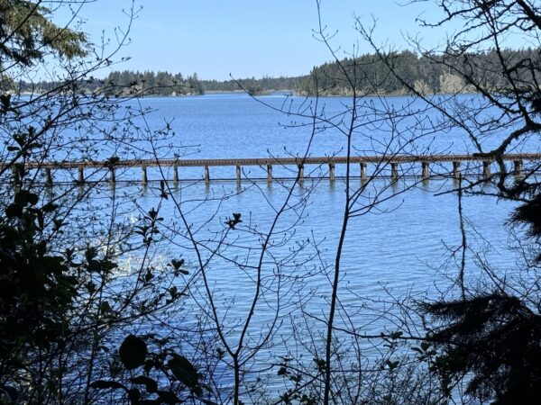
Along miles 12 to 14, there are broken views of two bridges carrying the rail line.
In total, the Coos Bay Rail Line traverses 121 bridges between Eugene and end of line in Coquille. The bridge structures vary in type and configuration, but include three steel swing span bridges, a variety of steel truss, through plate girder, and deck plate girders spans, concrete box spans, and a multitude of timber trestles. Many of the structures were first built when the line was constructed in 1914 through 1916, and many of the steel structures are now more than 100 years old.
Ada / ~ Mile 18
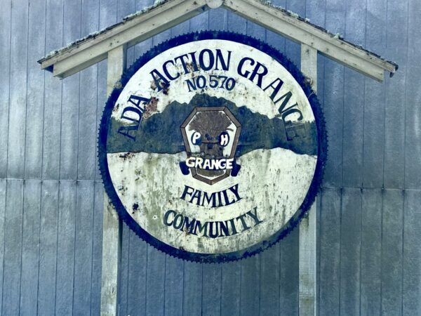
Ada is an unincorporated community that is unique in several ways. (1) It is one of Oregon’s rare place names attributed to a first name. The community was named for Miss Ada Wilkes, daughter of Benjamin and Jaretta Wilkes, longtime residents of the area. (2) It is an Oregon palindromic place name, a name that reads the same forward and backwards.
Dunes Viewpoint / ~ Mile 20
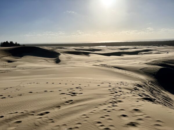
The sand in the Oregon Dunes is from the Coast Mountain Range, which is sedimentary rock that was uplifted 12 million years ago. As rock was moved downstream by rivers, it tumbled and abraded itself into sand. The present shoreline stabilized 6,000 years ago. Tides, wave action and strong coastal winds moved sand up to 2.5 miles inland for thousands of years. This area of dune development rests on a gently sloping terrace of solid marine sandstone called the Coos Bay Dune Sheet. This low rock surface stretches 56 miles from Heceta Head to Cape Arago and contrasts with steep headlands found on most of the Oregon coastline, which prevent inland movement of sand.
Cartilage Lichens / ~ Mile 22.3
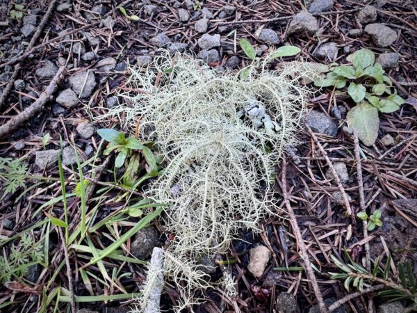
Lichens are sensitive to pollution and can highlight the quality of the surrounding air. More delicate beard-like ones are mostly found in locations with cleaner air. Mature and old growth forests are particularly important for lichen as they provide an undisturbed environment where lichen can thrive. Lichens need this as they take a long time to develop, growing only 1-2 mm a year.
Mature Trees / ~ Mile 26.5
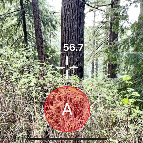
Mature or old-growth forests are important for several reasons:
Biodiversity: These forests provide habitat for a wide range of plant and animal species, some of which are rare or endangered and can only thrive in such environments.
Carbon Sequestration: Mature trees and forests play a crucial role in carbon sequestration, acting as significant carbon sinks. By absorbing carbon dioxide from the atmosphere, they help mitigate the effects of climate change.
Water Regulation: Old-growth forests help maintain water quality by filtering rainwater and reducing runoff, thereby preventing soil erosion and water pollution.
Sweet Creek Falls Trailhead / ~ Mile 32
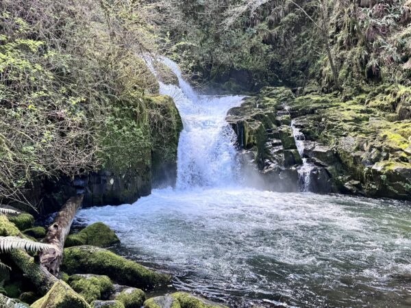
Stop and do this hike! It is wonderful. The hike is ~ 1 mile round-trip. We did it in mountain bike shoes (i.e., flatter soles than road shoes).
This waterfall has multiple tiers, but it’s impossible to see them all at once. If you stay on the trail, you’ll actually only see the bottom falls. Keep following the trail up, and a very short distance, to a viewpoint of one of the upper tiers. Note that there are seven different waterfalls in this area.
Salmon Culvert / ~ Mile 47.3
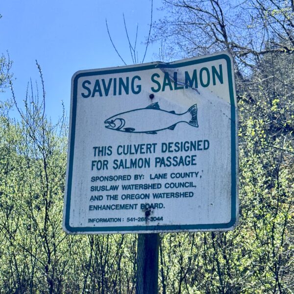
Along the route you will several signs like this. Older designed culverts often do not allow fish to pass. The downstream end of the culvert may be too far above the water’s surface for upstream migrating fish to enter. Water in the culvert may be moving too swiftly, or be too shallow for fish to pass in either direction. Debris may also collect in the culvert, blocking fish passage.
Culvert improvements typically involve lowering the downstream end of the culvert to the water’s surface, reducing the steepness of the culvert, and making design modifications to reduce water velocity and increase water depth in the culvert.
The Bathhouse / @ End
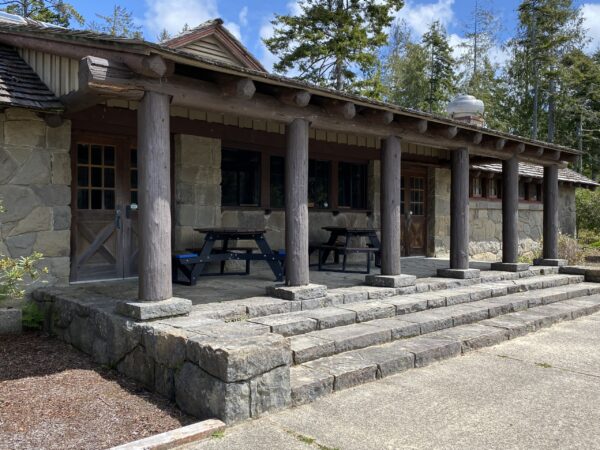
As you look across the water from the dock (the finish!), you will see the Cleawox Lake Bathhouse. From 1936 to 1941, the Civilian Conservation Corps (CCC) developed Honeyman State Park. Their work includes the stone and log Cleawox Lake bathhouse (1938); the park caretaker’s house and garage (1936-37), now the park office; and several rustic kitchen shelters (1937). The Civilian Conservation Corps was a work relief program that operated from 1933 to 1942 in the United States, providing young men with jobs related to the conservation and development of natural resources in rural lands owned by federal, state, and local governments, as part of the New Deal efforts to combat the Great Depression.
Credits & Acknowledgements
This ride guide was made possible in part by funding from the Oregon Coast Visitors Association.
When We Like to Ride This
We really like this route in the spring (~ late March to early June) when the flowers are starting to bloom, the trees are budding out, and the creeks are running full.
The route can be ridden most of the year. The maximum elevation is 1400 feet. Thus, on a sunny winter day in the mid 40s it is a possible go for the more “hard-core” rider.
Terrain & Riding
The route is a mix of rural, remote, and very remote areas. The remote sectors are Popo Road and NF 24/Maple Creek. See below for more detail.
The route also shows as 70% paved, but 23 of the 38 paved miles are single-lane paved logging roads. They are usually heavy chipseal, rutted, cracked, and debris strewn with branches, twigs, pine needles, etc. They are roads that you prefer to have more than a road bike tire on.
The Stick Sector of the Lollipop / Miles 0 to 6
This is a very deceptive sector. It starts out super fun on some wide single-track trail through the park that is forested with big old trees. But when you gain the road proper, thinking it will be easy, it is not. You gain and lose 500 feet in first 2 miles. Expect some short steep gradients of 10%.
Siltcoos Lake Sector / Miles 6 to 19
This is a not to be missed sector! The road is narrow, winding and quiet; all the while following Siltcoos Lake through a canopy of big mossy trees and roadside ferns. The elevation profile is deceptive. It looks flat, but is is very up /down, never gaining more than 100 feet in a single roller, but pithing up to 16% at times. 2.5 miles along the lake are gravel.
As you roll into Ada, the sector becomes “flatish” winding along Fiddle Creek and past wetlands. At the Ada grange you go left and climb on paved road through a recently logged hillside. Grunt it up! This marks the end of the sector, but not the climb.
Popo Road Sector / Miles 19 to 30
At ~ mile 19, turn right onto Popo Road (Po-Po, not Pop-o!) and continue climbing.The total climb is ~ 2 miles and 750 feet of gain, making for an average gradient of just over 6%. The Popo road is a single-lane logging road; chip sealed, broken in spots, with sunken grades, cracks and tree debris. This road is seldom traveled.
At ~ mile 20, you enter Siuslaw National Forest and second growth forest. Here, you begin on an undulating ridge climb (from mile 20 to 30) that dips up and down a lot, but continues to gain elevation. This is classic Coast Range timberlands. Steep embankments, mossy trees, ferns, and prickly bush.
At ~ mile 22 Popo road becomes gravel. Hard-packed and single lane.
At ~ mile 28 there is a bail-out option. It is gravel road (NF-2480) that reconnects to the original route just before mile 40. It “saves you” 7 miles and 1000 feet of elevation gain.
Sweet Creek Sector / ~ Miles 30 to 34
This is deeply forested downhill descent that follows Sweet Creek. Fun! The upper section is a logging truck paved road (i.e., rutted, cracked, broken, etc.) As you approach the falls, expect a bit more traffic. The very end of this sector is a proper county road with a painted dividing line down the middle. Along the way, you pick up many small creeks feeding into Sweet creek, something you did not have on the Popo sector.
Make sure you do the hike to the falls!! It is at ~ mile 32, about two-thirds the way down the descent. The hike is about 1 mile round trip. Expect vibrant colors, cascading waterfalls, old growth trees covered in moss and lichen, ferns, flowers, and more.
NF 24/Maple Creek Sector / Miles 34 to 48
The sector begins with a two-stepped climb up the NF-24 road. The lower steep is the steepest, at average gradient of 8.6% with a maximum gradient of 13%. The upper step averages out to 7.5%. There is a nice respite between the steps, a little over a mile long. Total elevation gain is 1150 feet.
At ~ mile 39.5 where the bail out road comes in, take the “less paved” road to the right. This road section sees little traffic as it is impassable by motorcycle, car, or truck due a landslip (not a landslide!) at mile 41.5 It is relatively easy to get through, but be cautious and patient. The drop is about 10 to 15 feet, some may butt slide down it as Gravel Girl did. It would be super cool if someone found a simpler go-around for the landslip. Something just above or below the old road.
At ~ mile 42 begin a gravel descent. It has some steeper pitches at 8 to 11%, but the average gradient is 7%. This section is not highly technical. At the end of descent, ~ mile 45, you begin to follow Maple Creek, spinning easy past meadows and green farm fields.
The Return on the Stick of the Lollipop / ~ Miles 48 to Finish
Yes, it is paved but deceptively difficult. It has two short punchy climbs, pitching up to 9%. Once you reach the lakes, it is super easy and fun riding back in on the single-track and paved path. You finish out the you ride by zipping out to the end of the dock. Look across the lake to see the historic bathhouse. Now, eat and refresh … and go hike the dunes!
The Start
Honeyman State park, sand dunes parking area. Flush toilets. Water. Parking permit required, available on-site.
Food & Water
- None
Route Notes
We recommend a red blinky light with a rear looking radar detector, something like a Garmin Varia. Several sectors of the ride are rural with traffic — the lakes and near Sweet Creek Falls.
Log trucks. This is the Coast Mountain range, a region where logging trucks are commonly encountered. Signs indicating logging activity include CB channels posted, mile markers, truck tracks in the dirt, pink ribbon, thinning activity, and a well-maintained gravel road. For safety, we recommend riding single file, using a rear red blinking light, and a front white blinking light. It’s important not to exceed your sight lines, and avoid listening to music, as hearing is crucial to detecting approaching trucks. If you encounter a truck, whether it’s coming towards you or overtaking, stop and place a foot on the ground instead of trying to ride through. Additionally, a friendly wave to the truck driver is always appreciated.
There are several options for camping:
- Honeyman State park (limited cell reception).
- Port of Siuslaw Campground near Old Town.
- Lane County Park (Harbor Vista) on north side of jetty.
- Along with several private campgrounds.
Route Options
Shorter
Skip the Siltcoos Lake Sector. This eliminates 9 miles and 400 feet of gain. At mile 9 continue straight, rejoining the original route approximately 1 mile later. 45 miles / 4900 feet of gain.
Bail Out. At ~ mile 28 there is an option to bail on the Sweet Creek Sector. Go north on the gravel road (NF-2480) This is a will eliminate 7 miles and 1000 feet of elevation gain.
Sweet Creek Falls Start. Start the ride from the Sweet Creek Falls trailhead, ~ mile 23 on the route map, and ride just the loop proper. About 32 miles with 3900 feet of gain.
Love Where You Ride! Learn More
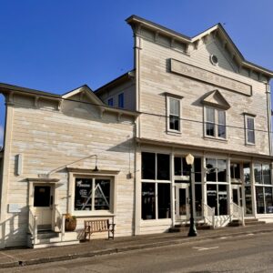
 Florence captivates us with its natural beauty and rich history, offering various ways to immerse in each. To experience its natural allure, consider hiking through the dunes at Honeyman State Park or exploring the Siuslaw River jetty from the parks located on both its north and south sides. For a taste of history, take a leisurely walking tour of Old Town. Here, you can visit unique shops, stroll through charming pocket parks, admire local art, and learn from informative kiosks. Additionally, don’t miss the opportunity to visit the Siuslaw Pioneer Museum, just a block away from Old Town.
Videos
The Ride! Honeyman
A quick 3+ minute video of what to expect on your ride (2 minutes) and things to do in Florence (at the end, 1 minute).
Beauty out of Chaos: Sand Dunes
Learn all about sand dunes! How they form. How they move. What sand is. This is a fascinating and informative watch. 16 minutes.
Podcasts
Oregon Sand Dunes
Dr. Win McLaughlin, a geology professor at Southwestern Oregon Community College, provides us with a deep understanding of the geology, history, and ecology of the Oregon coast. The Oregon coast is filled with unique geology which is characterized by its young age and the presence of sand [...]
Keep it Local! Learn More
Related Guidebook
Ridden and Reviewed by:


 Behind every route is scouting, mapping, storytelling, and a whole lot of pedal power.
Have you ridden this route? Got a question? Join the discussion!