Hauling Lava


Caution! We do not provide turn-by-turn directions in our GPX files. Those are auto-generated by your bike computer and are usually less than 70% accurate. Learn more.
For help loading a GPX file onto your bike computer, go here.
DownloadHighlights & Remarkable Spots
Old Haul Road / ~ Miles 0 to 2.5
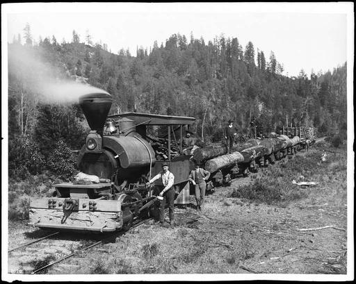
The Haul Road Trail follows the path of Bend’s old mill railroads, once used to haul ponderosa and douglas-fir logs from the surrounding forests to the Brooks-Scanlon and Shevlin-Hixon mills along the Deschutes. At their peak in the early 1900s, these mills operated one of the most extensive private rail networks in Oregon, running for nearly 70 years. The system supported not just trains, but entire portable towns on rails—complete with bunkhouses, schools, commissaries, and even a movie theatre—that could move deeper into the forest as the timber was cut. [Ref: The Old Mill]
Upper Deschutes River / ~ Miles 0 to 5
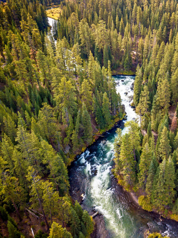
The Upper Deschutes once ran with remarkable stability, its spring-fed flows fluctuating less than 8 inches across the seasons. Today, irrigation storage at Crane Prairie and Wickiup reservoirs has transformed that rhythm. Winter flows can plunge to 100 cubic feet per second (cfs), while summer releases surge above 2,500 cfs to meet farm demand. This artificial pattern scours banks, degrades water quality, and leaves sediment deposits in places like Bend’s Mirror Pond. Wildlife adapted to steadier conditions—such as redband trout and Oregon spotted frogs—struggle with these rapid swings. To address the damage, the Deschutes Basin Habitat Conservation Plan (a multi-party collaborative plan) advocats for winter flows to rise gradually, reaching 300 cfs by 2028 and 500 cfs by 2033. Conservation groups, irrigation districts, and the ranching/farm communities are also pursuing canal piping, farm efficiency upgrades, and water banking to return a measure of balance to this altered river system.
Big Rock! / ~ Mile 0.2
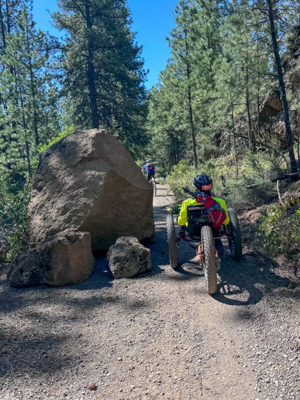
Several winters ago, this giant rock came crashing down from the hillside above (to your right). It brought with it three smaller boulders with it—which we’ve since moved aside—but this one was far too massive to budge.
Nature set the stage for this dramatic fall. Over many years, water seeped into tiny cracks in the rock embankment. Each freeze and thaw cycle acted like a wedge, slowly prying the rock loose until one final push sent it tumbling downhill.
How big is it? Our staff geologist, Kim Ely, estimates its weight at about 25,000 pounds—that’s as heavy as eight mid-sized cars or five full-grown elephants!
Ryan Ranch Meadow / ~ Mile 1.3
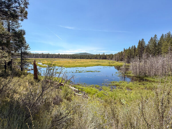
Ryan Ranch was once a vibrant wetland connected to the Deschutes River, but in the 1920s ranchers built a berm to keep floodwaters out and create pasture. The change dried the marsh into a meadow, cutting it off from the natural river cycle. Nearly a century later, the Forest Service is reversing that decision. A pilot restoration project has opened culverts in the berm, allowing seasonal flows to return and re-flood the basin. Over 65 acres of wetlands are being revived, transforming the landscape back toward its original form.
Benham Falls / ~ Mile 4.1
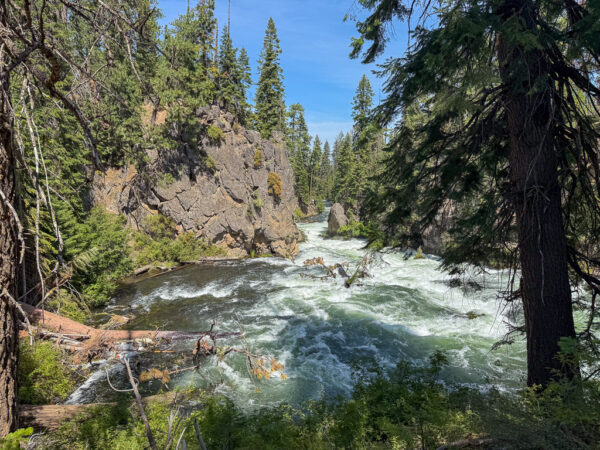
About 7,000 years ago, a massive lava flow from nearby Lava Butte dammed the Deschutes River, forming a temporary lake. When the river finally overtopped the hardened basalt, it carved a new channel through the rock, creating the tumbling cascades we see today. With a 25-foot drop across a 40-foot span, Benham Falls is the largest and most dramatic waterfall on the upper Deschutes. Its swift, frothing waters are rated Class V for whitewater.
Lava Flow / ~ Miles 6 to 9
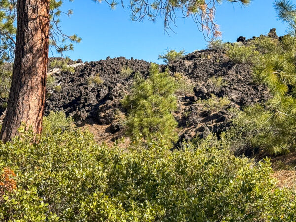
As you ride along the trail, look to your left to see the Lava Butte flow. It started as pāhoehoe (pah-HOY-hoy) lava, a smooth, ropy type of lava that spread out easily and formed tubes. As it cooled and released gas, it changed into ‘a‘ā (AH-ah) lava, which is jagged, blocky, and made of broken chunks that knocked down trees and other obstacles. This shift from pāhoehoe to ‘a‘ā is an important sign of how eruptions can change over time. The rough boulder fields to your left are the remains of the ‘a‘ā lava. Click here to learn more!
Lava Lands Visitor Center / ~ Mile 9
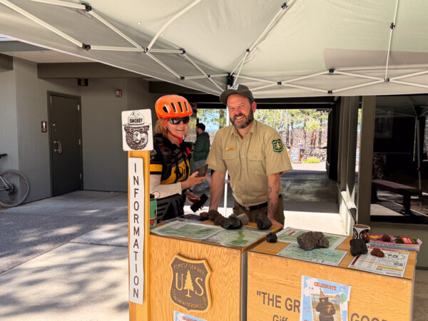
Make sure to visit the Lava Lands Visitor Center, where learning isn’t passive—it’s immersive and hands-on. A giant 3D map shows the size of the Newberry National Volcanic Monument, including its lava flows and cinder cones. Interactive exhibits let you test the weight of different rocks. You will learn about different types of lava and the rocks they create. Cultural displays trace over 10,000 years of people living in this volcanic region, with examples of obsidian tools and artifacts. Rangers are on hand to answer questions, and daily films offer deeper insight into the area’s geology, ecology, and history.
Lava Butte / ~ Mile 9+
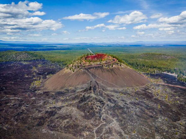
Lava Butte is a cinder cone that formed about 7,000 years ago in a single eruption. That event sent a lava flow across 9 square miles, blocking the Deschutes River and briefly creating a lake upstream. Rising 500 feet above the surrounding plain, Lava Butte’s summit holds a crater 150 feet deep. Its rugged, alien-looking terrain caught NASA’s attention: in 1963, Apollo astronauts trained here for lunar missions, learning to recognize volcanic features and practice sample collection.
Credits & Acknowledgements
This ride guide was funded in part by a grant from the Deschutes Trails Coalition.
When We Like to Ride This
This route rides well from spring through late fall. It is at a bit higher elevation than Bend, so it tends to hold more snow in the spring. But, once the snow has melted out, the route drains free and clear of water quickly.
In the spring, we love the roaring waters of the Deschutes River and the green grasses and blooming wildflowers. In the fall, we love the change of colors and the soft light reflecting off the river and between the trees.
In the summer time, between Memorial Day and Labor Day, segments of the trail can be busy. Go slow, be courteous, wave and say hello, and just take in nature. This is not a time of year to make your best Strava time.
Terrain & Riding
The ride begins on the old haul road, once a railroad bed for logging, now a wide dirt and gravel trail. The tread alternates between firm, smooth single-track (over 38 inches wide) and a broader gravel path measured in feet rather than inches. This sector is closed to vehicles. At ~ mile 2.6, the route shifts onto a double-wide gravel road for 1.6 miles leading to Benham Falls. Here, expect occasional car traffic. From there, the ride continues on a paved multi-use path for about five miles to the Lava Lands Visitor Center. You’ll share space with hikers but not motor traffic.
The grades are gentle with no big hills, making the ride accessible to many types of bikes and riders. Adaptive athletes on trikes and quads have successfully completed the route. There is one gate with tight clearance at ~ mile 1, where most adaptive riders will need help passing through. We’re working with the Forest Service to improve this pinch point and invite adaptive riders to share feedback in the ride guide comments.
Tall ponderosa pines frame the ride, while manzanita and snowbush fill the understory. We love how their red bark glows when caught in dappled light. The Deschutes River slips in and out of view, sometimes glassy and calm, sometimes spilling in lively cascades. Watch for flashes of black rock through the green—remnants of lava flows.
At the start, drop down to the water’s edge if you can. This is a serene pocket, often busy with rafters launching into the current. Yet the calm belies the river’s true power: the haul rail line was built here to skirt the many falls and rapids between Benham Falls and Bend’s Old Mill District.
The Start
Dirt parking lot. Pit toilets. Forest Service Recreation pass required. Not sold on-site, purchase in advance.
Food & Water
- ~ mile 9 / Lava Lands Visitor Center (seasonal)
Route Notes
There are two main ways to view Benham Falls:
- At mile 4.1 (parking area): A hiking-only trail, about 100 yards long, leads to a viewpoint where you can look upstream at the falls. This trail is not recommended for those using adaptive bikes.
- Just past the parking lot (along the wide dirt trail): Several viewpoints provide a chance to see the cascading falls from above. Many people prefer this perspective.
At the Lava Lands Visitor Center(seasonal—check hours), visitors can arrange to take a bus to the top of Lava Butte. Or you can also walk or bike up the butte. It is about 1.25 miles, with a one mile long climb averaging 8% grade.
Route Options
Longer
If you’d like a longer ride, try Water & Lava—a more technical and extended variation of Hauling Lava.
Love Where You Ride! Learn More
 This route really highlights the upper Deschutes River, a natural jewel in the heart of the Central Oregon community. But many of us are unaware that the river upstream of Bend is in big trouble. Its ecology is at a tipping point and showing steep declines in fish, wildlife and vegetation. We must act now before it is too late. Take a moment to learn more on the Deschutes River Conservancy website.
Videos
Act Now to Save the Deschutes River
A 2-minute video detailing the threats to the river and what we can do to help. Get educated and advocate!
Podcasts
Ryan Ranch Meadows
Ryan Ranch area was homesteaded in the 1890s. In the 1920s a berm along the Deschutes River was constructed to keep the river from flooding valuable pasture land. Prior to this, the area historically functioned as an emergent freshwater marsh that was connected to surface flows from the [...]
Keep it Local! Learn More

Outfitters

Related Guidebooks
-

All Access Gravel Guide Eastern Oregon (Collector’s Edition!)
$12.50Now shipping! A 64-page pocket-sized gravel guide. Featuring gravel routes, art, culture and local history. A one of a kind…Add to cart -

All Access Gravel Guide Western Oregon (Collector’s Edition!)
$12.50Now shipping! A 64-page pocket-sized gravel guide. Featuring gravel routes, art, culture and local history. A one of a kind…Add to cart
Ridden and Reviewed by:


 Behind every route is scouting, mapping, storytelling, and a whole lot of pedal power.
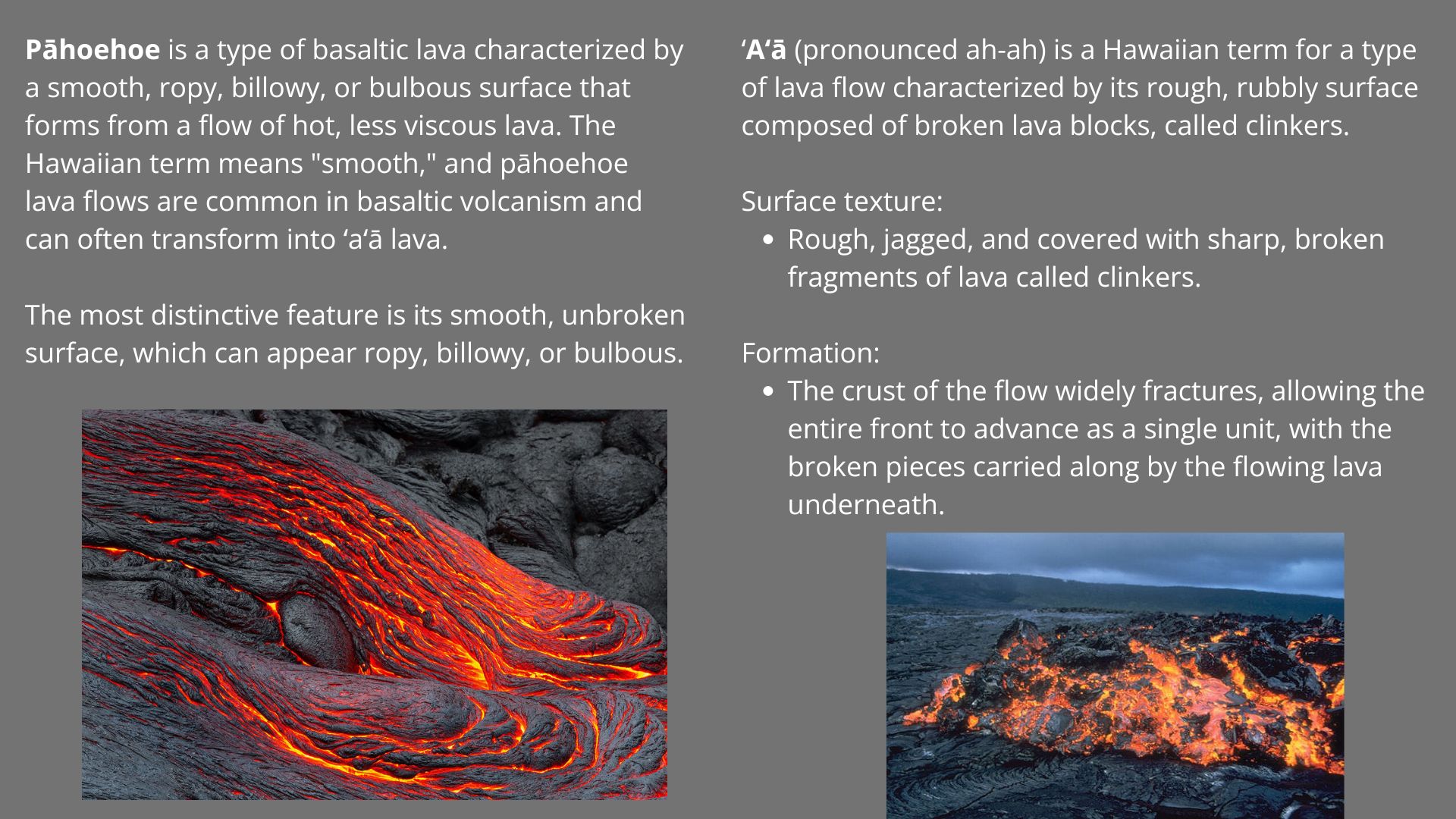
Have you ridden this route? Got a question? Join the discussion!