Gummy Lick
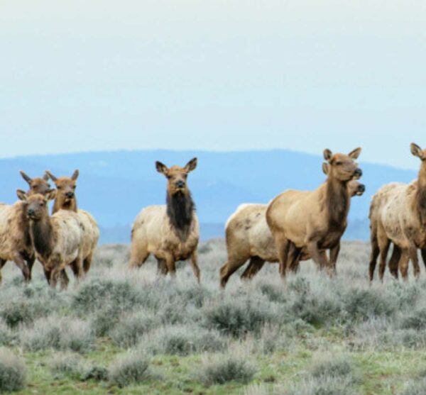
To minimize your impact on wildlife, please limit your group size to 4 or fewer. Learn more!


")


Caution! We do not provide turn-by-turn directions in our GPX files. Those are auto-generated by your bike computer and are usually less than 70% accurate. Learn more.
For help loading a GPX file onto your bike computer, go here.
DownloadHighlights & Remarkable Spots
Lick Creek Guard Station / ~ Mile 2
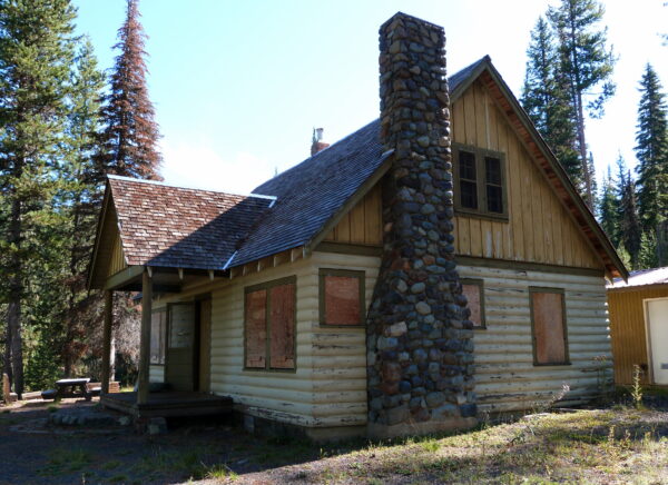
The Lick Creek Guard Station was built by the Civilian Conservation Corps during the Great Depression. The Civilian Conservation Corps (CCC) was a voluntary government work relief initiative in the United States, active from 1933 to 1942. Targeting unemployed, unmarried men aged 17–28, it aimed to alleviate the employment challenges faced by families during the Great Depression. Part of President Franklin D. Roosevelt’s New Deal, the CCC provided manual labor jobs focused on conserving and developing natural resources in rural areas owned by federal, state, and local governments. [Wikipedia]
Gumboot Creek Fish Interpretive Site / ~ Mile 10
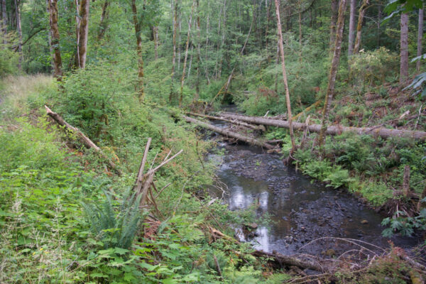
The Gumboot Creek Fish Interpretive Site provides information about the benefits of logs in streams for fish habitat. Large woody debris serves several crucial functions in stream ecosystems. It slows down water flow and aids in retaining gravel, vital for salmon and steelhead in building redds and laying eggs. It helps regulate water temperature and offers hiding places for fish, protection from predators, and traps organic matter, nourishing insects and invertebrates that serve as fish food. [Deschutes Land Trust].
Imnaha River / Miles ~ 15-20
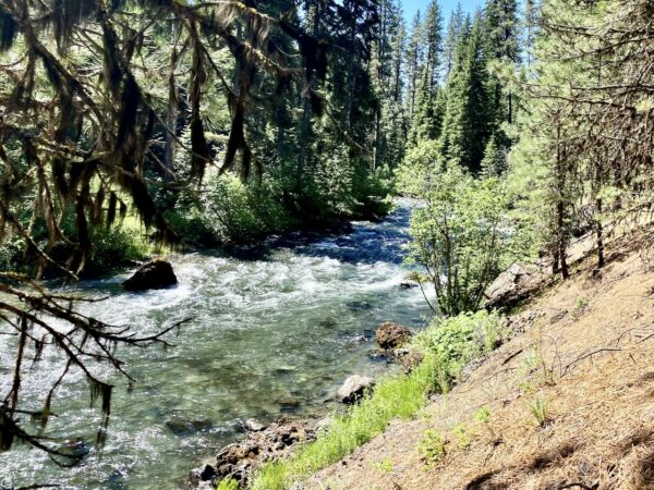
The Imnaha River flows 77 miles to the Snake River and traverses a blend of Forest Service-managed and privately-owned lands. The river corridor supports a distinctive array of plant communities and a wide spectrum of ecosystems, spanning from an elevation of 8,000 feet to 950 feet. The Imnaha River Canyon serves as a testament to the economic and social history of the area. It reflects the adaptability of the Nez Perce and subsequent Euro-American settlers to the region’s climatic and geographic conditions. Moreover, it preserves the traditional Western farm and ranch lifestyle, which remains vibrant and active in the present day. [Rivers.gov]
Seven Devils Mountain View / ~ Mile 27.5
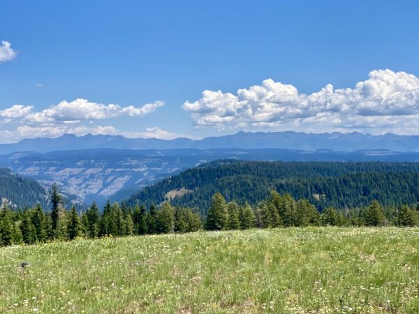
Across the Snake River and the Oregon/Idaho border lie the Seven Devils Mountains. An extinct volcanic range, the Seven Devils comprise the western most chain of the Rocky Mountains. With peaks as high as 9300 ft, the Seven Devils hold mountain goats, spectacular summer wildflower blooms, and over 90 alpine lakes. You can see these snow-capped peaks from this route. [US Forest Service]
Eagle Cap Wilderness / ~ Mile 31
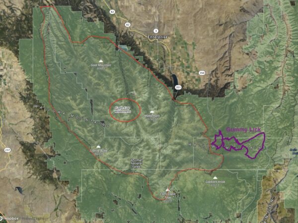
The Eagle Cap Wilderness is situated within the heart of the Wallowa Mountains and is characterized by high alpine lakes and meadows, rugged granite peaks and ridges, and valleys shaped by ancient glaciers. At 359,991 acres of designated wilderness, it has a rich history, having been initially inhabited by the ancestors of the Nez Perce Indian Tribe around 1400 A.D., followed by the Cayuse, Shoshone, and Bannocks. In 1930, the Eagle Cap was designated as a primitive area, later gaining wilderness status in 1940. The Wilderness Act of 1964 incorporated it into the National Wilderness Preservation System. Click on map for full screen view. [US Forest Service]
Lick Creek Bridge / ~ Mile 32
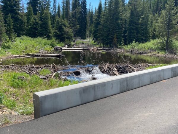
Prior to 2015, the road crossed Lick Creek here via a culvert. The culvert crossing was recognized as an impediment to young salmonids in the mid-2000s and was replaced with a bridge in 2015. This project effectively opened passage for various species: 2.5 miles of spawning and rearing habitat for steelhead, 1 mile of rearing habitat for young spring Chinook salmon, 5 miles of spawning and rearing grounds for bull trout, and approximately 2.5 miles of spawning and rearing habitat for Pacific lamprey. [Grande Ronde Model Watershed]
Lick Creek Trailhead / ~ Mile 35
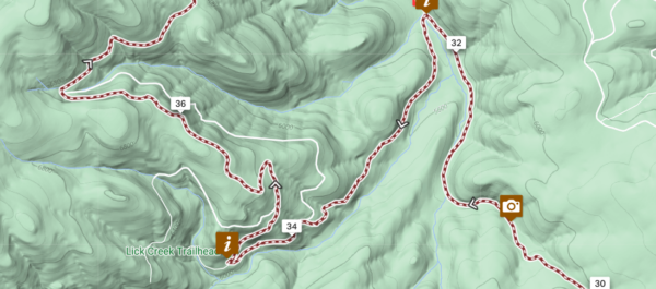
Lick Creek Trailhead offers visitors a small information board, limited parking, and is an entrance into the Eagle Cap Wilderness. [US Forest Service]
When We Like to Ride This
Prime time to ride this route is mid June to early August. Wait until after the snow melts, and the flowers are in full bloom, with strong running creeks and snow still on the mountain peaks. Note that the road is closed by snow from late October through late May or early June and is not passable with motor vehicles.
Terrain & Riding
This is a ride that is more forested than open. There are some beautiful ridge top views of the Seven Devils Mountains and the Eagle Cap Wilderness peaks. You will pass through forests of spruce, mountain hemlock, Douglas-fir, western larch, and lodgepole pine with wildflowers like Indian paintbrush, sego lily, larkspur, shooting star, and bluebell. Another highlight of the route are the flowing rivers and creeks: Lick creek, Gumboot Creek, Skookum Creek, and the Imnaha River.
Miles 0 to 2 / Lick Creek Sector
The ride starts out immediately beautiful, following Lick Creek on a double-track OHV road. There are open meadows and wildflowers and an cool wooden bridge crossing of the creek.
Miles 2 to 15 / Gumboot Creek Climb & Descent
This sector is all paved and easy riding. The initial climb is 1.7 miles at a 5% gradient followed by a descent of 2000 feet over 10.5 miles. You start high above Gumboot creek and descend with several S-turns to the creek itself.
Miles 15 to 20 / Imnaha River
This sector gently climbs at 1% through mature ponderosa pine forest with lush grasses and the river to the left. Exquisitely beautiful (and easy!).
Miles 20 to 32 / Skookum Creek
This is the beginning of the “real” gravel for the day. Immediately you kick into a climb begins with an 8% average gradient for 2.5+ miles. The surfaces are variable – from fast hard-packed gravel, to slower, more technical rock cobble. But … along the way you get some terrific views of the Seven Devils Mountains.
Miles 32 to Finish / Lick Creek Loop
Do not skip this loop, it is so, so scenic! Maybe the highlight of the ride. But it is not easy. The first 4 miles climb 1200 feet. At the hard-right turn at the Lick Creek Trailhead (mile ~34.5), the road turns primitive, the most primitive of the day. Expect double track with a grass strip down middle of the track. You are rewarded with grand vista views. You peak out at a max elevation of 6800 feet. From here, it is a 3.5 mile drop of 1000 feet on rugged road. A tough end to the day, but so worth it!
The Start
Small dirt pull-out on the north side of Forest Service Road 39.
Food & Water
- None
Route Notes
Much of this ride is within the Hells Canyon Recreation Area and Wallowa-Whitman National Forest, a super special place for wildlife. As a rider of this route, you will have an impact on the wildlife even if you don’t see the wildlife! (And, in most cases you won’t.) To minimize your impact, there are a couple of simple things you can do:
- Limit your group size to 4 or fewer and keep your group together (no more than a 100 yard distance from the first rider to last rider).
- If you see big game wildlife like deer, elk, bear, or mountain goats stop and put a foot down. Let the animals check you out and let them move on when they are ready. This is a great time to get pictures and watch. But, do not try to approach closer to get a better picture. Give the animals there distance and space.
- Minimize your noise signature. Do not whoop and holler. Keep everthing to a conversational voice.
We have a resource page on Wildlife Impact that goes into a lot more detail, check it out here!
We recommend a red blinky light with a looking radar detector for the paved sectors of this route. Something like a Garmin Varia.
Regarding tire choice, no matter what you choose, part of the day will have too much tire and part of the day too little tire. 40 mm tires are doable, 50 mm tires will be more comfortable.
Route Options
Shorter Options:
- At ~ mile 28, go right on NF 3950 and return to the route at ~ mile 4 and return on paved to the start. Route: 35 miles, 3100 feet of gain.
- At ~ mile 32 continue straight on Cloverdale Road instead of turning left. Reconnect with NF 39 (paved) and follow it back to the start, about 2 miles. Route: 35 miles, 3100 feet of gain. More gravel than the option #1.
Love Where You Ride! Learn More
 The Wallowa-Whitman National Forest spans 2.4 million acres across northeastern Oregon and western Idaho. With diverse ecosystems ranging from alpine peaks like the Wallowas, Elkhorns, and Seven Devils ranges (up to 9,843 feet), to the stunning grasslands and canyons around the Snake River (down to 875 feet), this area boasts ten Wild and Scenic Rivers, four Wilderness Areas, and the renowned Hells Canyon National Recreation Area.
In 2021 the US Department of Agriculture granted $3 million to the Northern Blues Collaborative Forest Landscape Restoration Proposal. With a 10-year timeline, partners will mitigate the risk of severe wildfires on approximately 900,000 acres of National Forest, Tribal, State, and private lands. One of those partners, The Northern Blues Forest Collaborative, has a vision to provide a place for respectful dialogue, where people from historically antagonistic circles such as forest contractors, environmental advocates, tribal governments, local government and community, private property owners and recreationists can listen to and learn from each other. To learn more about the collaborative process necessary between people from such a breadth of society, visit the website of the Northern Blues Forest Collaborative.
Videos
The Ride! Gummy Lick
A quick 2-minute video of what to expect on your ride!
Podcasts
Thinning, Mowing and Fire (Making our forests healthy again!)
“What happened here?” That is a common reaction many have after seeing the immediate impact of the tree thinning and forest mowing work in the Phil’s network of trails. In this podcast, we talk with Melanie Fisher from the Deschutes Collaborative Forest Project to discuss [...]
Be Informed!
Keep it Local! Learn More
Ridden and Reviewed by:


 Behind every route is scouting, mapping, storytelling, and a whole lot of pedal power.
Have you ridden this route? Got a question? Join the discussion!