Greenwaters


Caution! We do not provide turn-by-turn directions in our GPX files. Those are auto-generated by your bike computer and are usually less than 70% accurate. Learn more.
For help loading a GPX file onto your bike computer, go here.
DownloadHighlights & Remarkable Spots
Middle Fork of the Willamette River / ~ Start
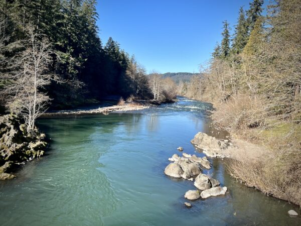
The Middle Fork of the Willamette River is approximately 100 miles long, originating at Timpanogas Lake, about 40 miles southeast of Oakridge. It joins the Willamette River near Springfield, just outside Eugene. Along its course, the river is dammed three times: Hills Creek Dam (furthest upstream), Lookout Point Dam, and Dexter Dam.
These dams are essential for for flood control, hydroelectric power, and water storage. However, they also disrupt fish migration and the river’s natural flow. Efforts are ongoing to balance human needs with ecological restoration along the river. (Map)
Bull Trout / @ The River & Reservoir
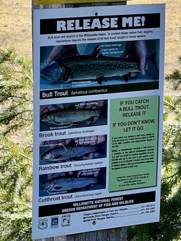
The Middle Fork of the Willamette River is one of the few places where the threatened bull trout continues to thrive.
Native to Oregon, bull trout are protected under the Endangered Species Act and serve as an indicator species of a healthy, cold, and clean water ecosystem. Their survival depends on well-oxygenated water below 55°F year-round. (That’s cold!) Bull trout also thrive in the Metolius, McKenzie, Malheur, John Day, and Imnaha Rivers.
As top predators, bull trout primarily feed on other fish. Migratory individuals can grow over 30 inches long and weigh more than 10 pounds, making them one of Oregon’s largest native trout species.
To protect these rare fish and the ecosystems they represent, strict catch-and-release regulations are enforced in Oregon waters.
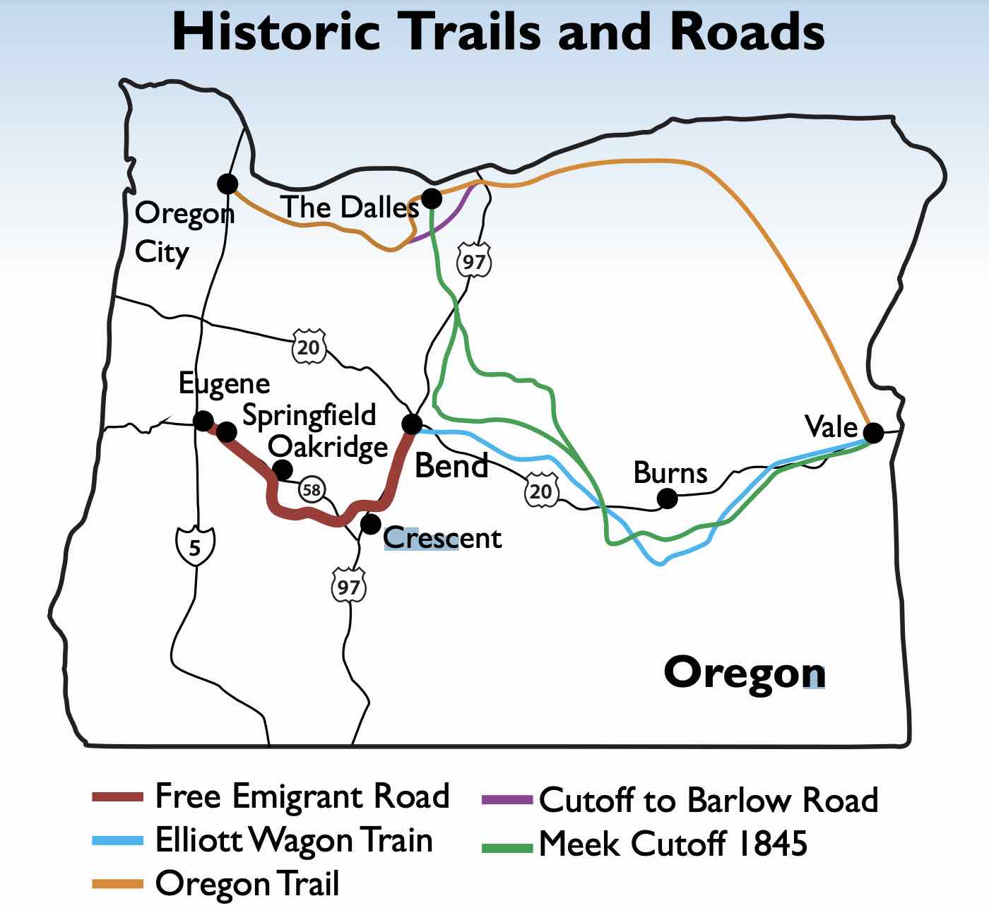
Free Emigrant Road / ~ Miles 12 to 26
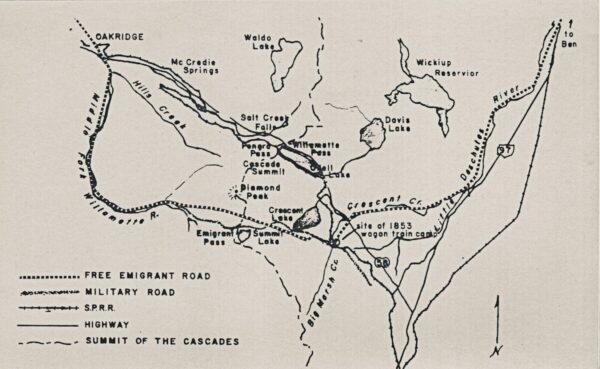
For the next 14 miles, you’ll roughly trace the route of the Free Emigrant Road. (Click on map.)
In 1853, a wagon train led by Elijah Elliott attempted this shorter route to the Willamette Valley. The emigrants faced severe hardships, including harsh weather, starvation, and nearly impassable terrain in the Cascades. With dwindling supplies and broken wagons, they endured grueling conditions until settlers from the Eugene and Oakridge areas organized a rescue approximately 3.5 miles south of the southernmost point of Hills Creek Reservoir, delivering life-saving provisions. From Oakridge to Eugene City, they followed the riverbed, crossing it 27 more times. Read the full story here.
Hills Creek Dam / ~ Mile 25.5
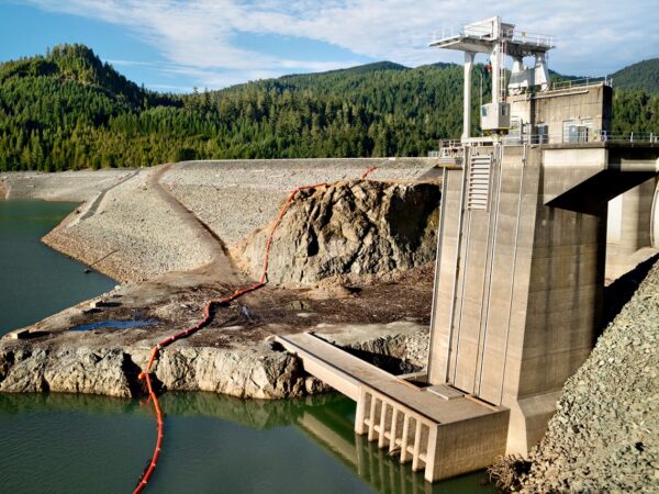
Hills Creek Dam is a 304-foot tall, 1,920-foot long rockfill earthen embankment dam with a concrete spillway, three spillway gates, an intake structure with regulating outlet, and a powerhouse. Hills Creek dam is owned, operated, and maintained by the U.S. Army Corps of Engineers (USACE). Construction of the dam began in 1956 and was completed in 1961. Hills Creek is part of a system of 13 multi-purpose dams in the Willamette Valley with the primary purpose of flood risk management and secondary purposes of hydropower.
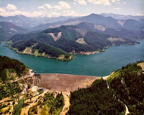
During the winter months, the reservoirs are maintained at their lowest elevations to allow for the temporary storage of rain and snowmelt. When managing high flow events, the outflow from the system of dams is coordinated to reduce peak flows. In spring, the Army Corps begins to fill the reservoirs. During summer, stored water is used for recreation on the reservoirs, and some stored water is released in the river downstream to improve water quality, produce hydropower, support fish and wildlife habitat, and provide water for irrigation and municipal uses. During dry summer months, flows into the reservoirs are generally less than flows needed to meet minimum flow objectives, causing reservoir levels to drop. In fall, stored water remaining in the reservoir is drawn down to minimum levels in preparation for the flood season.
John J. Hill Cabin / ~ Greenwaters Park
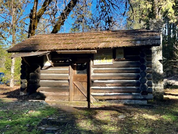
Pioneer cabins were typically small, 200 to 400 square feet, built from locally sourced logs with mud or moss to seal drafts. They featured wooden shingle roofs and minimal windows. Inside, the cabin was simply furnished with a table, chairs, sleeping pallets, and shelves for essentials like tools and dishes. Dimly lit by oil lamps or candles, meals were cooked over an open fire, relying on staples like bread and preserved meat. Hills Creek, named after John J. Hill, commemorates his settlement near its mouth in 1870, with the dam and lake also carrying his name.
Credits & Acknowledgements
This ride guide is funded in part by a grant from Travel Oregon.

When We Like to Ride This
On a warm winter / spring day when the sun is shining. This is a great “winter escape” ride, with little to no traffic, and great lighting. We like a noon start, as the latter half of the ride is heavily tree covered and can have some areas that hold frost throughout the morning. We do not recommend this ride from Labor Day through Memorial Day, too much traffic along the lake.
Terrain & Riding
An excellent winter ride with no big climbs and descents, just rollers; with the exception of one climb near the dam, 5% grade for just over a mile.
The first and last miles through Greewaters park are on a wide single-track trail that hugs the Middle Fork of the Willamette River as it rambles through a stand of old-growth forest … big old, mossy trees. A really special piece of the ride!
After exiting the park, there is a short transition gravel road to the lake loop. Hard-packed and fast. The route then loops around Hills Creek Reservoir in the clockwise direction. The first 14 miles are paved, twisting and rolling, with an overhanging canopy of trees. Along the way, there are peek-a-boo views of the lake. In the early spring, the lake levels are low, the light is soft, and the colors are vibrant. Something we find uniquely beautiful.
At mile 12, the southern most point of the route, the Middle Fork flows into the reservoir. In 2 miles, the gravel begins. The route continues to roll and twist. The road can be wet and marked with some dips and divots, but it still rides fast.
Cross a concrete bridge where Hills Creek flows into the reservoir, pick up the paved road, drop down pat the dam and then pick up the stick of the lollipop; a bit more gravel and then the old-growth forest through Greenwaters park.
The Start
Greenwaters Park. Flush toilets. Use the east most parking lot. There is a donation box near the Community Hall building. We recommend a $5 donation per vehicle.
Food & Water
- None.
Route Notes
CAUTION: Around mile 18.4, there’s a sudden drop in the otherwise smooth gravel road, followed by several large potholes. Pink ribbons in the trees may mark the spot. We believe this is a temporary condition and will be repaired soon. If you ride the route, please leave a comment to let us know what you find.
We recommend a red blinky light, as the lake loop road does get some traffic and with the tree cover, it can be difficult to see cyclists.
The single-track sectors at the beginning and end are very wide trails (48″ minimum), quite flat, and non-technical.
Love Where You Ride! Learn More
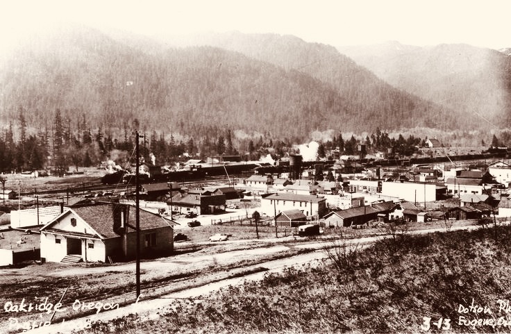 The area now known as Oakridge was first explored by Euro-Americans in 1852 as they searched for routes connecting Central Oregon to the Willamette Valley. Initially, the community was called “Hazeldell,” with a post office established on July 26, 1888. When the Southern Pacific Railroad opened a station in May 1912, a railroad executive named it “Oak Ridge,” inspired by the surrounding landscape. Later that year, on July 19, the name was officially changed to the single word “Oakridge.”
Oakridge has experienced periods of economic booms and downturns. Its first major boom came with the arrival of the Southern Pacific Railroad in the early 1900s. By the late 1940s, it had become a thriving timber town, with the Pope and Talbot mill employing over 500 workers. However, the town faced challenges when the mill closed in the 1980s and 1990s.
Today, Oakridge has a population of just under 3,500 residents. The town has reinvented itself as an outdoor recreation destination, proudly branding itself as the “Mountain Bike Capital of the Northwest.”
Videos
The Ride! Greenwaters
A quick 2-minute video of what to expect on your ride!
Oakridge: Then & Now
A 4-minute video exploring Oakridge's evolution from a timber town to a regional hub for outdoor recreation. This small town located in Central Oregon is a biking destination for gravel cyclists and mountain bikers.
Keep it Local! Learn More
Related Guidebooks
-

All Access Gravel Guide Eastern Oregon (Collector’s Edition!)
$12.50Now shipping! A 64-page pocket-sized gravel guide. Featuring gravel routes, art, culture and local history. A one of a kind…Add to cart -

All Access Gravel Guide Western Oregon (Collector’s Edition!)
$12.50Now shipping! A 64-page pocket-sized gravel guide. Featuring gravel routes, art, culture and local history. A one of a kind…Add to cart
Ridden and Reviewed by:


 Behind every route is scouting, mapping, storytelling, and a whole lot of pedal power.
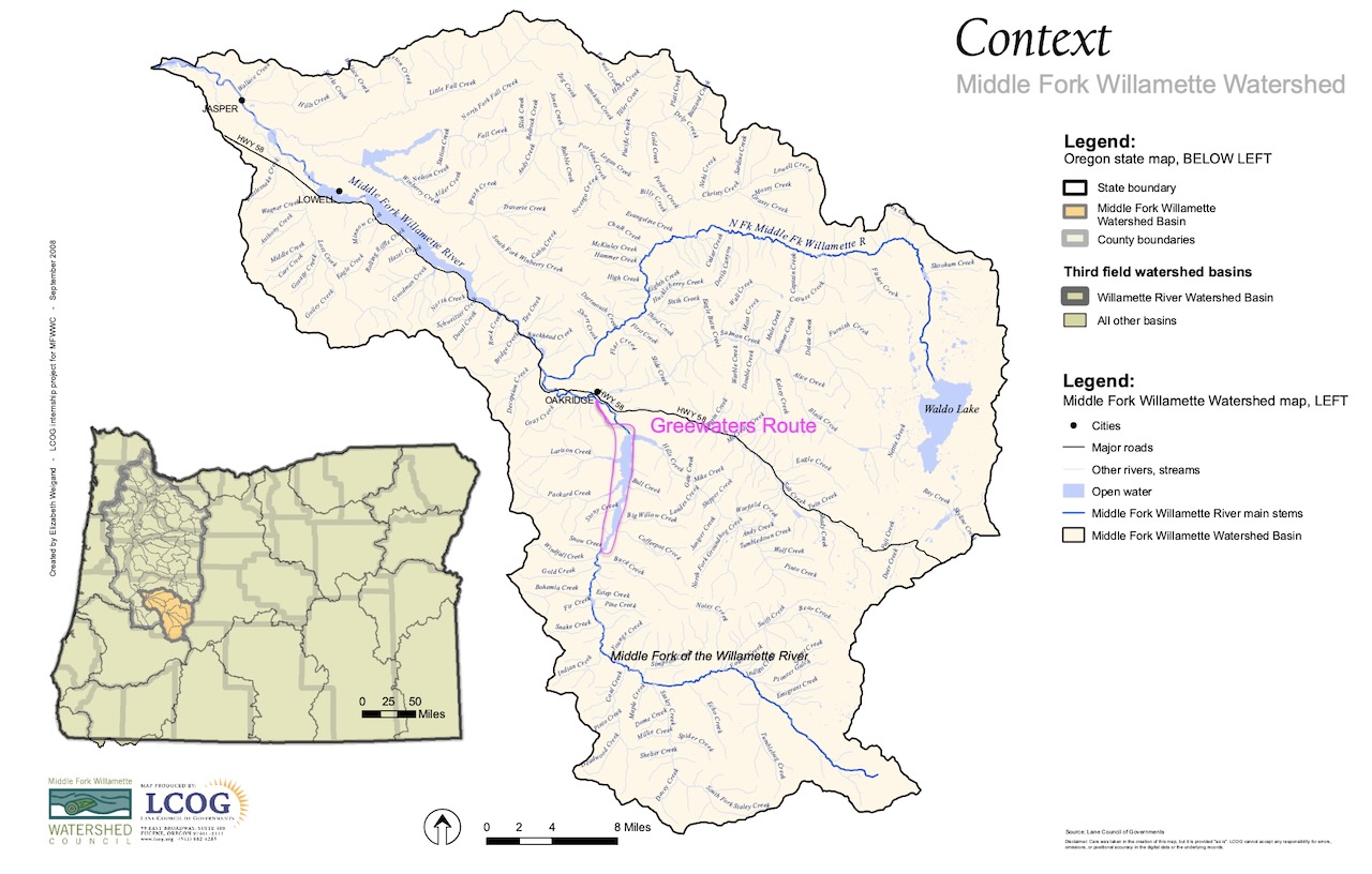
Have you ridden this route? Got a question? Join the discussion!