Green Ridge Lookout


Caution! We do not provide turn-by-turn directions in our GPX files. Those are auto-generated by your bike computer and are usually less than 70% accurate. Learn more.
For help loading a GPX file onto your bike computer, go here.
DownloadHighlights & Remarkable Spots
Metolius River / ~ Mile 2
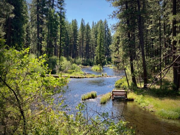
The Metolius River is renowned for its exceptional clarity, constant temperature and unusual north flowing direction. Emerging fully formed from underground springs at the base of Black Butte, this spring-fed river maintains a steady flow and temperature year-round, typically around 48°F. Its crystal-clear waters support a thriving population of native rainbow trout and bull trout. European settlers first arrived in the mid-1800s, establishing homesteads and eventually founding Camp Sherman in 1911.
Camp Sherman / ~ Mile 3
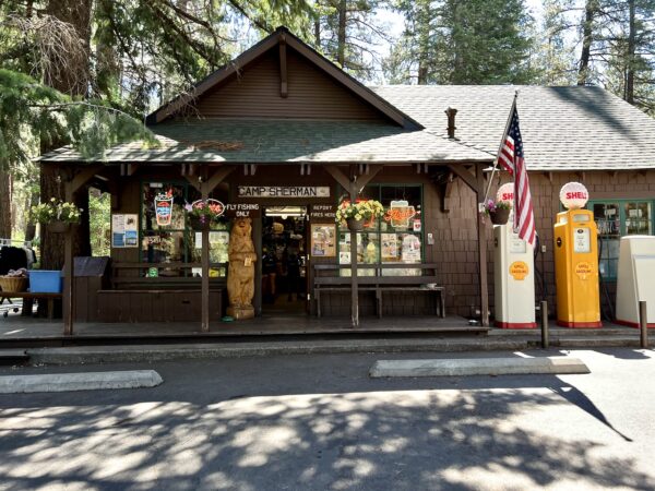
Camp Sherman is named after the wheat farmers of Sherman County who vacationed here after the summer harvest. Circa 1910.
In the early 1900s, portable logging camps and small-gauge railroad tracks spiderwebbed through these forests. When an area was logged-off, the rails were moved to another area, the logging camp cars (supplies, bunkhouses, kitchens and even a small church) were either moved on their specially made boxcars or made to be loaded onto railcars and moved to the new location.
Wizard Falls Fish Hatchery / ~ Mile 7.5
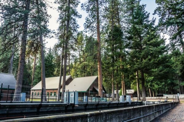
At mile 6.6, the Wizard Falls Fish Hatchery turn will be to your left. Make the short detour and go!! You will get a great view of the river at the bridge crossing and see some cool fish. “Nestled along the Metolius River, the hatchery raises Steelhead, Brook and Rainbow Trout along with Kokanee and Chinook Salmon. It has several display pools and a viewing pond for kids of all ages to feed the fish.” [Oregon Department of Fish & Wildlife]
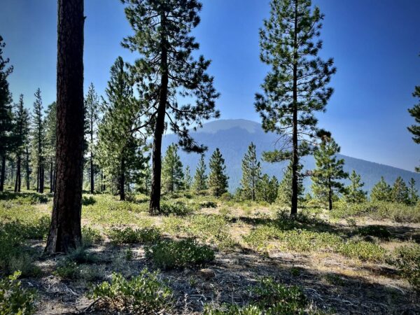
Green Ridge Fires / ~ Mile 13 to 25
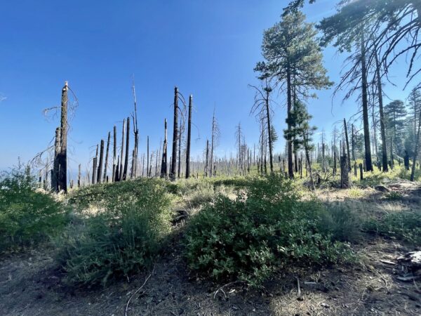
The next 13 miles will undulate up and down the ridge through recent burns and offer up stunning views. The riding is a mix of single-track, double-track, dirt road, and gravel road. From north to south, the fires include Bride 99 (2014), Wizard (2008), Metolius RNA (2002), Green Ridge (2013) and Green Ridge (2020).
Green Ridge Lookout / ~ Mile 19
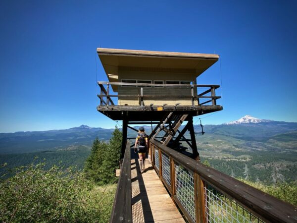
The entrance to the lookout is marked by a locked gate. Beyond the gate, it is 0.5 miles to the lookout; this is not to be missed! But, take notice that it may be in use by guests. Please respect their privacy.
Green Ridge & Black Butte / ~ Miles 20 to 23
Three to five million years ago, the rocks of Green Ridge were laid down. More recently (1.5 million years ago), the Cascade mountains formed. Ensuing pressure along north-south fault lines eventually lifted the older rocks of Green Ridge to form the magnificent miles-long hillside that cradles the Metolius River against the Cascade slopes. When Black Butte rose up, a mere half-million years ago, it plugged the south end of that trough, thereby ensuring that the Metolius River would ever after flow north. [The Nugget Newspaper]
When We Like to Ride This
This route rides great in the spring/early summer when the “washboard” is less.
Terrain & Riding
For surfaces, this route is a real variety pack with a perfect blend of gravel roads, single-track, and paved roads. The single-track has a smidge of the rocky stuff. The gravel roads, for the most part, are hard-packed, with a bit of washboard, mostly avoidable.
The climb at mile 9 gains 2000 feet in 5.5 miles with an average gradient of 6.5%. The lower portion of the climb is on a wide, red cinder road that is buffered by pine trees. About halfway up, the road texture changes to dirt with rocky embedded chunks. It is all rideable, but choosing the best line is important to minimize your effort and keep your momentum. This sector also offers up stunning views of the Cascade Peaks to the west due to fires in 2008.
At mile 28.2, you have the option of taking red cinder roads back to the start (right on NF 1120, left on NF 1430 and right on NF 14), but we have opted for an option with a bit of skinny single-track along a high alpine meadow and a little used dirt road. It gets steep (8%) and, in spots rugged. It is short, just over 1.5 miles. But we think this option is so much better than riding down the red cinder washboard
For the terrain, expect big ponderosa trees, fabulous river and mountain views and a patchwork of burned areas.
The Start
Black Butte Trailhead. Dirt lot.
An alternative start is at the Camp Sherman store, but public day use parking is very limited. We like to use the this start outside of the summer season when we have a small group.
Food & Water
- Mile 3: Camp Sherman Store
- Mile 8: Wizard Falls Hatchery
Route Notes
We recommend a red blinky light with a rear-looking radar detector like the Garmin Varia for the paved sections.
This route rides best in the direction as mapped.
The entrance to the lookout is marked by a locked gate. Beyond the gate, it is 0.5 miles to the lookout; this is not to be missed! But, take notice that it may be in use by guests. Please respect their privacy. More information about the lookout can be found on the Deschutes National Forest website.
Note – we did a major revision to this route guide in 2021 due to the Labor Day fires of 2020. We have re-routed sections, we have changed the direction of the ride, and we have added a few new elements along Black Butte. Be sure to download the new GPX files.
Route Options
If you are looking for a bigger ride, consider adding in some options from the GravelCracker 60, the GravelCracker 85, or Sherman’s March.
Another option is the route by Our Mother The Mountain, Metolius: Green Ridge + Wizard Falls.
Love Where You Ride! Learn More
 The Green Ridge single-track trails on this route are maintained by the Sisters Trail Alliance. Trails cost money! Please consider making a contribution to their campaign or your local trails organisation so that they can continue the great work!
Videos
Trail Etiquette (Horses, Hikers & Bikers)
Whether you like to hike, bike, or ride a horse, we all want to enjoy our trails safely. Learn how to share the trail respectfully!
Keep it Local! Learn More

Ridden and Reviewed by:


 Behind every route is scouting, mapping, storytelling, and a whole lot of pedal power.
Have you ridden this route? Got a question? Join the discussion!