Glass House
Due to the Warner Peak Fire in August 2024, this route is closed until June 15, 2025. Details here.


Caution! We do not provide turn-by-turn directions in our GPX files. Those are auto-generated by your bike computer and are usually less than 70% accurate. Learn more.
For help loading a GPX file onto your bike computer, go here.
DownloadHighlights & Remarkable Spots
Hart Lake / ~ Miles 0 to 6
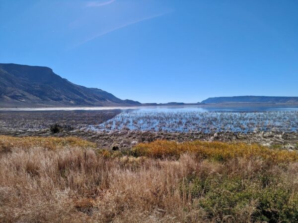
The amount of water in the Warner Valley lakes is determined primarily by the volume of snowmelt and rain in the surrounding basin. Enough precipitation needs to occur in the basin to fill Crump Lake (south of Hart Lake) high enough so the overflow fills Hart Lake and the overflow from Hart Lake fills the lakes to the north. With an evaporation rate of as much as 42 inches per year, the water levels of all the lakes can fluctuate widely from one year to the next and season to season. The depth of Hart Lake can vary from 11 feet to nearly dry.
Petroglyphs / Undisclosed
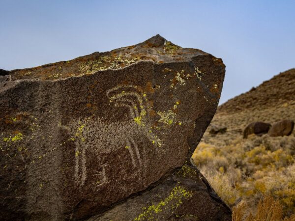
This area is home to some of the oldest archaeological sites in North America, reflecting 11,000 years of occupation by the Klamath, Modoc, and Yahooskin Tribes.
At the base of the escarpment, you’ll find car-sized boulders adorned with petroglyphs—ancient rock carvings that tell stories of the past. These intricate images depict hoofed animals, hunters with bows, half-human figures resembling insects or reptiles, and mysterious squiggles and lines.
Please be respectful and don’t touch the images or climb on the rocks; do take as many photos as you like.
Soldier Headstone / ~ Mile 7
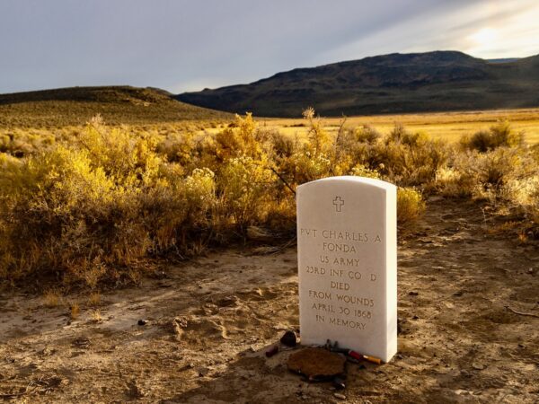
The soldier’s headstone marker commemorates Private Charles A. Fonda of the U.S. Army’s 23rd Infantry, Company D. He succumbed to his wounds on April 30, 1868.
Why this headstone marker is here and it authenticity is unknown.
Glass House / ~ Mile 7.8
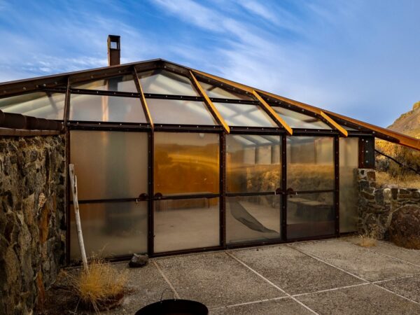
Once a private residence, now publicly owned, the Glass House is weird, wonderful and totally worth the effort. Built in the early 1990s, it was the vision of California wine grape grower Walt Benson, who constructed it with the help of a local man from Adel. This off-the-grid, below-grade outpost was designed to blend with the natural landscape and operate independently of conventional utilities.
You can no longer enter the house as it is locked, but you can peer inside and walk the outside.
Hart Mountain Viewpoint / ~ Mile 8.1
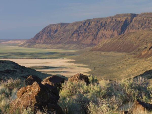
On your return, you get an exceptional view of Hart Mountain, a fault-block formation created by tectonic activity 20 million years ago. Its western face rises sharply from the Warner Valley, with a dramatic 3,600-foot escarpment, while its eastern slopes descend more gently, draped in volcanic flows and sediment layers.
Though often mistaken for a range, Hart Mountain is a singular massif crowned by two prominent peaks: Warner Peak, the highest at 8,024 feet, and Hart Peak, standing at 7,724 feet.
Credits & Acknowledgements
This ride guide is funded in part by grant from Travel Oregon.

When We Like to Ride This
We love this route during peak birding seasons—mid-March and October—but as the photo deck shows, it’s absolutely stunning in late July as well.
Terrain & Riding
This ride traces a scenic ribbon of dirt road nestled between the towering escarpment of Hart Mountain and the glistening waters of Hart Lake. The route gently twists and undulates as it hugs the lake’s eastern edge, threading through tall green grasses, open plains of desert sage, and pockets of wild rock formations.
The road surface is generally well-maintained and smooth for gravel riding. That said, expect a few short stretches—roughly 100 yards at a time—where embedded or loose rock is scattered across the path. These sections are fully rideable, and it’s easy to find clean lines through or around the chunkier bits.
The reward? Panoramic views in every direction. To the east, the massive wall of Hart Mountain rises dramatically above the valley. To the west, the wetlands shimmer, Hart Lake stretches into the distance, and the rugged silhouettes of the Albert Rim to the west and Lynch Rim to the south define the horizon. Birds are everywhere—expect to see (and hear) a lot of them.
Your destination is the Glass House, perched atop a small rise at the end of the route—offering a look at the vastness of the Oregon Outback.
The Start
Warner Wetlands parking area with kiosk and hiking trail.
Route Notes
This route is a birders paradise. From the parking are you can do a short walk to the north to several bird stands. Along the ride there are numerous spots to stop and observe.
The wetlands offer year-round sightings of diverse species, including raptors, waterfowl, shorebirds, secretive marsh birds, and songbirds. Spring and fall migrations bring an especially spectacular display, with large flocks of ducks, geese, swans, and coots passing through. Located within the Southern Oregon–Northeastern California (SONEC) region, a critical conservation area, the wetlands serve as an essential stopover for birds to rest and refuel during migration. Peak birding times typically occur in mid-March and October, though migration timing can vary based on species and weather patterns across the western United States.
The wetlands are not only a migratory haven but also a breeding ground and year-round home for several species, including BLM Sensitive Species like the American White Pelican, Yellow Rail, and Snowy Egret.
For bird enthusiasts, the Warner Wetlands is a must-visit destination to experience the wonder of avian biodiversity in a vital conservation landscape.
This ride takes you through the Oregon Outback Dark Sky Sanctuary—the largest Dark Sky Sanctuary in the United States, covering 2.5 million acres.
A Dark Sky Sanctuary is a special designation given to a place that has exceptionally dark night skies and is very remote or protected from light pollution. It’s one of the designations from the International Dark-Sky Association (IDA), which works to preserve natural nightscapes around the world.
Here’s what sets a Dark Sky Sanctuary apart:
Extreme Darkness: It’s one of the darkest places on Earth—ideal for stargazing and astrophotography.
Remote Location: Usually far from cities and artificial light sources.
Fragile Environment: Often in areas that are ecologically or culturally sensitive and need protection.
Conservation Commitment: The managing organization commits to preserving the darkness through outreach, education, and lighting policies.
The route is fully exposed: no shade, and winds can be a factor. Check the forecast, wear sunscreen, and plan accordingly.
Route Options
Longer Option
Start in the town of Plush, at the Hart Mountain Store. This option includes some road riding on quiet, low-traffic roads that pass through scenic farmlands and wetlands. Be sure to check in with store management about parking—and don’t forget to spend where you ride!
Distance: 28 miles
Elevation Gain: 600 feet
Surface: 55% gravel/dirt road, 45% paved
Lat/Long: 42.412073, -119.904229
GPX File: Download
Videos
The Ride! Glass House
A quick 2+ minute video of what to expect on your ride.
A Video Tour of Glass House
A 2-minute video tour of the Glass House, including some beautiful drone footage.
Keep it Local! Learn More
Related Guidebooks
-

All Access Gravel Guide Eastern Oregon (Collector’s Edition!)
$12.50Now shipping! A 64-page pocket-sized gravel guide. Featuring gravel routes, art, culture and local history. A one of a kind…Add to cart -

All Access Gravel Guide Western Oregon (Collector’s Edition!)
$12.50Now shipping! A 64-page pocket-sized gravel guide. Featuring gravel routes, art, culture and local history. A one of a kind…Add to cart
Ridden and Reviewed by:


 Behind every route is scouting, mapping, storytelling, and a whole lot of pedal power.
Have you ridden this route? Got a question? Join the discussion!