Deschutes River Trail


This ride takes you on a journey through two of Oregon’s most significant historical events, spanning from the mid-1800s to the early 1900s. Here, Oregon Trail emigrants crossed the Deschutes River, facing one of their toughest challenges. Later, this same landscape became the battleground for two competing railroad companies racing to reach Bend, an intense rivalry known as the Deschutes Railroad Wars.
Oregon Trail emigrants typically reached this site by late afternoon, facing one of their most challenging obstacles: the Deschutes River. Like many river crossings along the trail, this one was treacherous. Wagons, livestock, and emigrants all had to cross the river, and casualties were common.
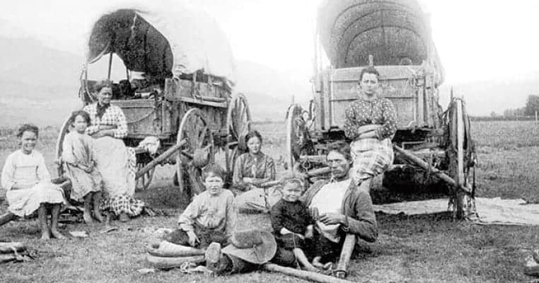
“The wind being high we could not ferry. We then concluded to ford it. The ferryman declared all would be lost, telling enormous lies to alarm us, but we employed an Indian guide who rode before each wagon, giving us the course to the island, the ford being very crooked; he than rode in front of one team, the rest following in a string, the course being nearly straight across the second channel. We paid him $2 for his services, all being across safe and dry. Our ferriage would have been $15; thus we saved $13 by fording.” Basil Longsworth, September 17-18, 1853
After a perilous river crossing, they ascended the hill immediately to the west, camping at the summit. Harriet A. Loughary, an emigrant of 1864, noted, “nothing indicates life except an occasional Juniper tree.” Weary emigrants found little comfort on the plateau: water, firewood, and browse for livestock was scarce.
The emigrant’s route is still visible across the river, particularly in early morning or late evening.
—
This is also the place where the ambition of railroad tycoons clashed, shaping the landscape and the future of Central Oregon. The early 1900s saw a fierce battle known as the “Deschutes Railroad War”, a competition between two powerful figures: James J. Hill of the Oregon Trunk Railway and Edward H. Harriman of the Deschutes Railroad.
These men were not just building railroads; they were vying for control of the region’s rich resources, especially its vast timber reserves. Central Oregon was a “railless land,” making a railroad the key to unlocking the area’s economic potential. Both men wanted to be the first to reach the heart of Central Oregon, the town of Bend.
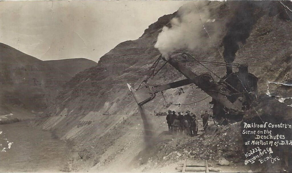
The Deschutes River Canyon became the primary battleground. Both companies began constructing parallel rail lines along the canyon’s steep walls, on opposite sides of the river. Harriman’s company, the Des Chutes Railroad, started on the eastern side of the river (the route of your ride), and Hill’s Oregon Trunk Railway began on the west side (the current railroad line). This led to a race to complete their respective lines.
The competition between the railroad companies was fierce. Construction crews engaged in acts of sabotage, such as blowing up the other side’s supplies, destroying tracks, and engaging in small gunfights. They also used legal tactics to impede their rivals, such as buying up land and water rights. The work was incredibly difficult, with crews using hand tools such as picks, shovels, and black powder to blast through rock .
The rivalry even extended into the courts as representatives of the two companies fought ongoing battles in Portland. At one point, Hill’s crews bought land that cut off Harriman’s water supply. The conflicts were not limited to sabotage and legal disputes. In one incident, a local sheriff and his deputies were driven out of a work site when they tried to intervene, and their horses were sent running into the desert.
The “war” eventually cooled after Harriman’s death. By 1910, Hill and Harriman’s successor, Robert S. Lovett, agreed to a truce and joint operation of some track sections. The two companies agreed to share track where it did not make sense to build parallel lines. Hill’s Oregon Trunk Line was the first to reach Bend in October 1911, marking the end of the conflict [1, 14]. The first train arrived in Bend on October 5, 1911. The Oregon Trunk Line ultimately became the dominant route.
The route is a simple out and back on the old Des Chutes Harriman railroad line.
Caution! We do not provide turn-by-turn directions in our GPX files. Those are auto-generated by your bike computer and are usually less than 70% accurate. Learn more.
For help loading a GPX file onto your bike computer, go here.
DownloadHighlights & Remarkable Spots
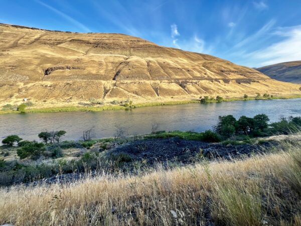
Oregon Trail Ruts Viewpoint / @Start
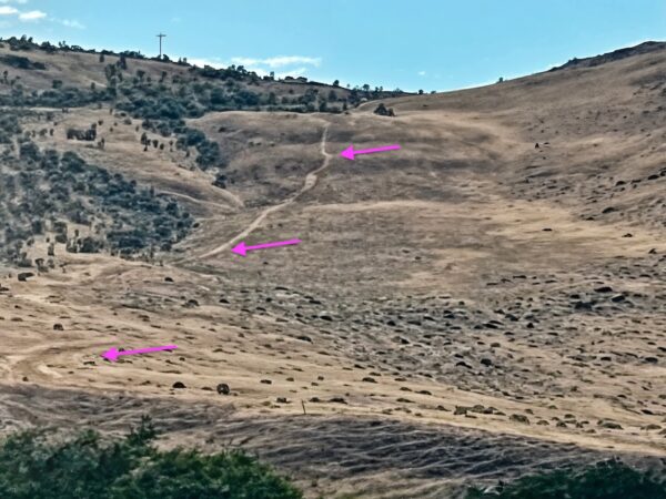
Walk to the water’s edge within the campground and look across the river to the hillside. If you look closely, you can spot the historic tracks of the Oregon Trail, dating back to the mid-1800s—nearly 200 years ago. The tracks are most visible at dusk.
Click on the image to the left to get an appreciation of what you are looking for. The image is highly zoomed in, which makes it appear slightly out of focus.
If someone takes a better quality image, please forward it on to us.
Deschutes Railroad Company (Harriman Line) / ~ Miles 0 to 11
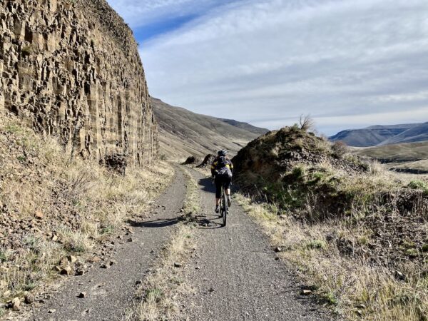
This trail was once a battlefield of the Deschutes Railroad Wars. Edward Harriman’s Deschutes Railroad Company carved this route into the canyon’s eastern wall, blasting through basalt in a desperate bid to outpace rival James J. Hill. Tracks were laid, but Hill’s competing line on the west side won control, rendering this grade obsolete before it saw real service. Look closely—timbers, tunnels, and blasted rock still tell the story of its short-lived existence.
Oregon Trunk Railroad (Hill Line) / ~ Miles 0 to 11
The tracks across the river (click on image to left) mark the path of the Oregon Trunk Railroad, the victor of the bitter Deschutes Railroad Wars of the early 1900s. Rival tycoons James J. Hill and Edward Harriman fought to control central Oregon’s rail access, racing to blast routes through the basalt canyons. Sabotage, dynamite raids, and courtroom battles defined the conflict. Hill’s line prevailed, shaping regional trade and settlement. Today, the line is still in use and un-altered from its original path.
Gordon Canyon Trestle / ~ Mile 3.5
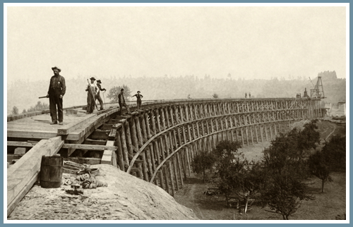
Here the old railbed arrives at Gordon Canyon. Trains used to travel on a high trestle here, but it no longer exists. Descend on a vehicle track to cross Gordon Creek and then head back up to the railroad grade.
The image to the left is indicative of a railroad trestle of the era, but is not the exact trestle that was at this location.
Free Bridge / ~ Mile 6.6
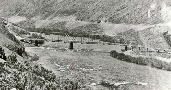
In 1873, John E. Harris constructed a wagon road leading down into and out of the Deschutes River Canyon, building a toll bridge. Wasco County bought it in 1887, making it free to use. A Pratt truss bridge replaced it in 1905, but in 1914, the entire structure mysteriously collapsed into the river. Since other Deschutes bridges remained private toll crossings, some evidence suggests the Free Bridge was deliberately dynamited by competitors unhappy with the loss of toll revenue.
On your ride, if you look closely, you can still see several of the original stanchions at the water’s edge.
Harris Homestead / ~ Mile 11.1
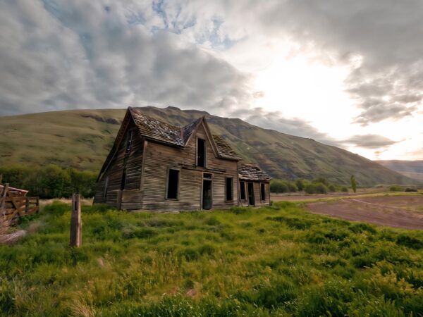
Until the July 2018 substation fire, there were remains of the Harris Homestead here – a house, corrals, cattle chutes, sheep shearing stalls, and open sheds with some farm equipment. As you continue further down the road, you would pass through an allee of hackberry trees and reach a grove of ponderosa pines with a refurbished caboose that was a residence for seasonal farmworkers. There was also a shed and paddock, as well as an outhouse and a small pump house. A little farther on, at the mouth of Harris Canyon, there was the Harris Canyon Water Tower.
When We Like to Ride This
This gravel ride is “goes” most of the year, sitting at approximately 400 feet above sea level.
We’ve ridden it in February on a sunny day, when the colors are soft yet vibrant. In spring, when the wild grasses turn green, and the river flows strong. In fall, when the winds are light, the morning air is crisp, the the sun-rays are warming. However, we don’t recommend it during the peak of summer, as the heat can be brutal!
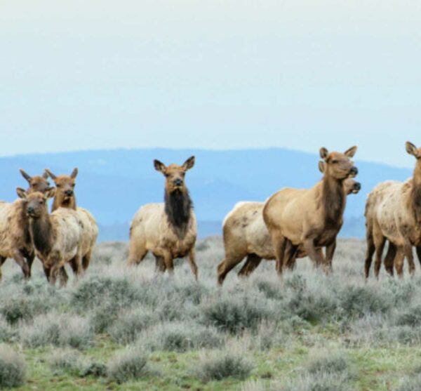
Please do not ride at dawn and dusk. This trail is sensitive wildlife habitat including quail, bald eagles, deer and more.
Terrain & Riding
All Access
The ride starts at state park where the Deschutes River merges into the massive Columbia River. This is where settlers along the Oregon Trail crossed the river. There is a kiosk just east of the parking area with the history of the Oregon Trail and the river crossing.
It’s an “easy smeasy” route (video), no tricky navigation and one hill that I would really call a dip. The surface switches from smooth to bumpy and back to smooth.
We recommend you “out and back” it to about mile 11 when the road starts to toughen up a bit. The turn around point is delineated by the burnt remains of the Harris Ranch from the July 2018 Substation fire.
Longer Options
If you don’t mind bumps and a more rugged journey, keep on going. The views continue to get better as the canyon walls close in.
At mile 19, you will hit the beginning of a 4 mile section that is very demanding. It is marked by some old timbers from the trestle bridge that was in place in the day. We really recommend that you turn around here. The route is just as beautiful on the way back but be warned, the wind whipping off the Columbia River can catch you, late afternoon or really any time.
If you continue, the old railway bed leads to Macks Canyon and a gravel road. But to make it through this stretch, you will have some “push / carry your bike” spots across six canyons where the trains made it easily upriver via wooden trestle bridges. You will also encounter a mix of rugged single track and double track. Rideable for some … not others. Plan accordingly, this 4 mile stretch is slow going.
The Start
Deschutes River State Recreation area. Flush toilets (seasonal).
Food & Water
- None.
Route Notes
This route is quite flat, however at ~ 3.5 there is a dip to negotiate, where an old railroad trestle had been. The maximum gradient is 9%, the sustained gradient is 7.4% for 0.3 miles. This section is easily walkable.
This area and this trail are known for “goatheads” and snakes. Goatheads are sharp, burly stickers that puncture tires at will.
We encountered no goatheads on our ride, but the longer route extension from mile 11 to 19 is an area to be vigilantly on watch for the vine with yellow flowers.
Here’s our best advice:
- Stay on the trail, do not wander off.
- Use tubeless tires with sealant.
- Top off your sealant before the ride.
- Carry extra sealant and a valve core remover with you. You may need to re-add sealant. Tire plugs are not a great option. You will run out of plugs before you get all the holes sealed. Only use on punctures that are not sealing.
- If goatheads embed themselves, leave them until the ride is over. If you pull them all out at once you will have too many holes for your sealant to fill. It will be a big fail!
- When finished with your ride, remove the goatheads. Otherwise, you will spread this noxious weed to other areas. The goathead can lie dormant for over 10+ years until the conditions are right for it to sprout and grow.
Yep, watch out for snakes. In 5 rides of this trail, we have seen only one, and that was in summertime. Rarely will you encounter a snake in the cooler temps of fall, winter, and spring. Rattlesnakes are most active when temperatures range between 70°F and 90°F.
Here’s what you can expect by season:
- Spring (March–May): As temperatures warm up, rattlesnakes emerge from their winter dens, typically in rocky areas or south-facing slopes. They are more active during the day but tend to avoid very cold mornings and evenings.
- Summer (June–August): Peak rattlesnake activity occurs during warm months, but they shift their behavior. They are most active in the early morning and late evening to avoid the extreme midday heat.
- Fall (September–October): Activity decreases as temperatures drop. Snakes begin moving back toward dens, and their presence becomes more sporadic.
- Winter (November–February): Rattlesnakes hibernate in dens, they are rarely present.
To learn more listen to our Snakebites! podcast with world renowned snake expert Dr. Nick Bradehoff of the Asclepius Snakebite Foundation. What you will learn is to be vigilant and aware while riding, give snakes plenty of room, and that very, very few people get bit.
Route Options
Longer Option
Continue beyond mile 11 to mile 19 for a total ride of 38 miles/700 feet of gain. Note, the elevation profile shown in RideWithGPS is accurate, but the elevation gain is not. The gain is 700 feet, not 1400 feet.
- Route: Deschutes River Trail (Long Option)
- GPX File: Download
Big Adventure
If you are looking for a bigger ride and bigger adventure, check out the Big Mack route. This is a loop and it is super demanding, do not underestimate it.
Love Where You Ride! Learn More
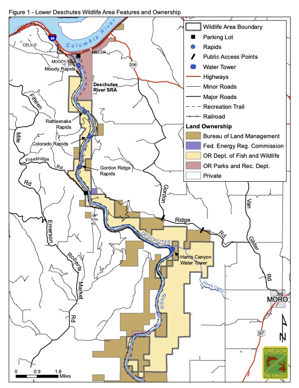 This ride is entirely within the Lower Deschutes Wildlife Area (click on map to right) spanning 18,724 acres of rugged canyon land. This is critical habitat for mule deer, bighorn sheep, river otter, coyote, golden eagle, red- tailed hawk, peregrine falcon, and more.
Managed by the Oregon Department of Fish and Wildlife, conservation efforts here are funded by federal excise taxes on firearms, ammunition, fishing, and boating equipment, as well as fish and wildlife license and tag fees.
To minimize your impact on wildlife, avoid riding at dawn and dusk. If you encounter animals, keep a distance of several hundred yards whenever possible. For more information, visit our Wildlife Impact page.
Videos
The Deschutes Railroad War
Railroad historian and attorney Martin Hansen talks about the race between two railroad barons to build a railroad line through central Oregon.
Podcasts
Snakebites!
Rattlesnakes scare the bejeezus out of most of us. But … should they really? In this podcast, learn more about rattlesnakes and what to do if you do get bit out in the wild. Our guest is Dr. Nick Bradehoff of the [...]
Be Informed!
Related Guidebooks
-

All Access Gravel Guide Eastern Oregon (Collector’s Edition!)
$12.50Now shipping! A 64-page pocket-sized gravel guide. Featuring gravel routes, art, culture and local history. A one of a kind…Add to cart -

All Access Gravel Guide Western Oregon (Collector’s Edition!)
$12.50Now shipping! A 64-page pocket-sized gravel guide. Featuring gravel routes, art, culture and local history. A one of a kind…Add to cart
Ridden and Reviewed by:


 Behind every route is scouting, mapping, storytelling, and a whole lot of pedal power.
Have you ridden this route? Got a question? Join the discussion!