Double Go!


")


This excursion ends at two of the largest waterfalls on the Oregon Coast: Golden and Silver Falls. Golden Falls was named after Dr. CB Golden one of the first visitors to the falls. Silver Falls, discovered later, and in a case of a mistaken impression, were named such to carry on the metallic named theme.
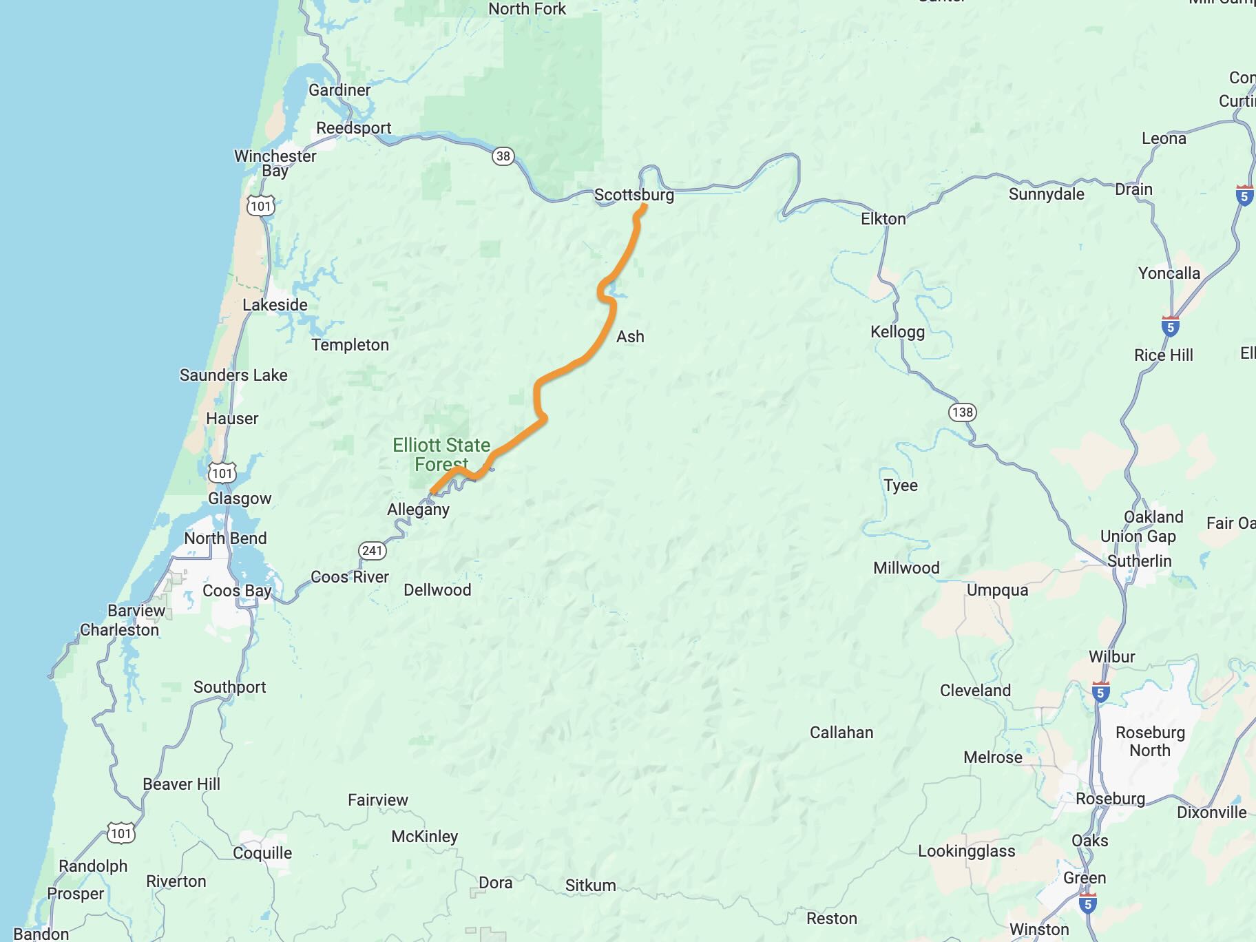
This route showcases the Allegany-Scottsburg Pack Trail, once the major connector from Marshfield (Coos Bay) to Scottsburg circa 1850 to 1950.
 The central district of Coos Bay was called Marshfield until November 10, 1944. The name change, long advocated by residents, had been voted for and became effective on November 11, thus matching the name of the Bay itself. There has been a permanent settlement on Coos Bay since 1853, when the town of Marshfield was founded there and named after the Massachusetts hometown of its founder, J. C. Tolman.
Scottsburg was a vibrant town along the Umpqua River half-way between the lower Willamette Valley and the Oregon Coast. It served as a seaport for Southern Oregon’s interior and also a transfer station for a stagecoach line from Drain at the southwestern edge of the Willamette Valley.
The Pack Trail from Marshfield (Coos Bay) to Allegany was serviced via the “mosquito fleet“; small maneuverable steamboats roughly 65 feet in length the could carry up to 100 passengers, livestock, and freight along the Coos and Millicoma Rivers. People and freight disembarked at Allegany and proceeded along pack trail in the early years by mule, horse and buggy and in the later years by early makes of cars.
The ride follows the old Pack Trail from Allegany to the bases of Silver and Golden Falls, first by paved road, then gravel road, then hiking trail. At the trailhead to Silver Falls, you embark (by foot) on the historic Pack Trail, a wide dirt path today. This sector was the crux of the historic Allegany-Scottsburg Pack Trail; it followed Silver Creek to the base of the falls, skirted under the falls via a wooden bridge, and then ventured to the top of Golden Falls.
About the name Double Go. Two waterfalls, and two modes of movement (bike + hike). Thus, Double Go!
Caution! We do not provide turn-by-turn directions in our GPX files. Those are auto-generated by your bike computer and are usually less than 70% accurate. Learn more.
For help loading a GPX file onto your bike computer, go here.
DownloadHighlights & Remarkable Spots
Steamboat Landing / ~ Near Start
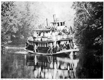
Near Allegany, the confluence of the east and west forks of the Millicoma River marks the location of an old steamboat landing. In the late 1800s and early 1900s, small, agile steamboats known as the “mosquito fleet” transported people, livestock, and goods up the river. This river transport served as the initial segment of the Allegany—Scottsburg Pack Trail.
Myrtlewood Trees / ~ Mile 3.2
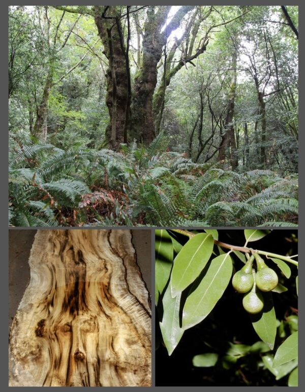
The Oregon myrtle (or California laurel, as it’s also commonly known) is an enigma. It’s neither a laurel tree nor a myrtle tree, despite its common names. This broadleaf evergreen, known officially as the Umbellularia californica, grows only on a narrow strip of inland land along the Pacific Coast, ranging from northern California to Oregon’s southern coast.
During the Great Depression, the town of North Bend, Oregon, faced a severe cash shortage like many other communities. In response, local businessman Amos Meade proposed using myrtlewood, a locally abundant hardwood, to create wooden coins as a form of scrip currency. The North Bend Chamber of Commerce approved the idea, and in 1933, they began issuing myrtlewood tokens in various denominations. These unique wooden coins were accepted by local merchants and circulated throughout the community, helping to stimulate the local economy during difficult times. The use of myrtlewood currency was relatively short-lived. [OPB]
CA Smith Logging Camp / ~ Mile 3.5
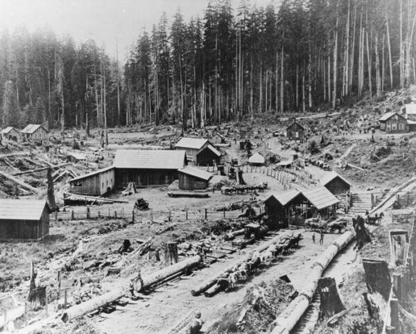
Across the river from Nesika County Park, C.A. Smith Lumber Company operated a logging camp in the early 1900s.Charles Axel Smith became, for a time, one of Oregon’s most powerful lumbermen, buying up huge tracts of forest land and developing the largest mill on Coos Bay. A native of Sweden, Smith emigrated to the U.S. to become one of Minnesota’s leading lumbermen by the late nineteenth century. With his company’s timber stands rapidly being cut over, Smith and other lumbermen in the upper Midwest began purchasing—through legal and illegal means—stands of virgin forests in the Pacific Northwest. C. A. Smith’s agents used dummy entrymen to fraudulently file claims to 160-acre tracts of timber and then transferred those titles to the Smith interests.
Golden Falls / ~ Mile 9.0
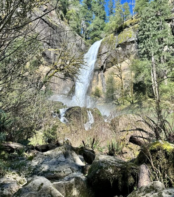
“Walk through the myrtle grove that shades the picnic area to cross Silver Creek on a footbridge. The trail splits at an ancient myrtle. Go right for the short trip to the base of Golden Falls. Glenn Creek flows quietly to your right, and mossy myrtles and big-leaf maples overhang the path. Pass through a sword fern/salmonberry thicket. A spur right leads to Glenn Creek and a summer paddle pool. After passing around a large boulder, you’ll see Golden Falls spilling over the cliff above. In summer, you can clamber through the boulder field for a closer view, but at all other times of year, this area becomes a running channel of Glenn Creek.” [Ref: Oregon Hikers]
Allegany to Scottsburg Pack Trail / ~ Mile 9.4
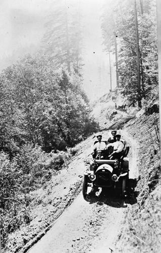
This dirt path was a pack trail that was transformed into a wagon road in 1901 by four homesteaders from the upper Glenn Creek valley above Golden Falls. The road was blasted out of the cliffs, crossing Silver Falls at their base on a wooden bridge, and then hugging the cliff to the top of Golden Falls, 250 feet above the creek. An automobile stage operated this route, barely wide enough to accommodate a Model T, between 1912 and 1916, running from Allegany to Scottsburg. During World War II lumber was transported over this road from a sawmill located about two miles above Golden Falls. The road was maintained by the county until 1958. [Ref: On-site kiosk]
Silver Falls / ~ Mile 9.7
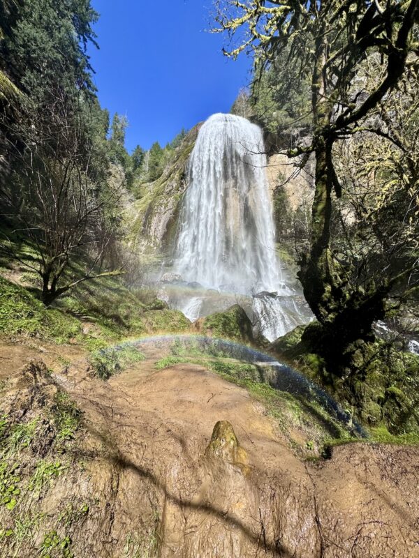
Go left from the parking area for Silver Falls. After walking past a white bollard, you’ll see the interpretive sign that describes the old homesteader road you’ll be hiking on. Tall old-growth Douglas-firs tower overhead, and alders, maples, and myrtles, also known as California bay laurel, shade Silver Creek.
Follow the old road track among the thimbleberry thickets. The trail negotiates a slide that has completely obscured the road track but is easily passable. When you reach a fallen Douglas-fir, you get your first look at the falls. Continue onward until you are into the spray. If lucky, you will see a giant rainbow!
Credits & Acknowledgements
This ride guide is funded in part by the Oregon Coast Visitors Association.
Much of the historical content for this Ride Guide is from Southwestern Oregon Community College (SWOCC) 2018 and 2019 spring term F251 Forest Recreation class Virtual Field Trip video and the book, “Above the Falls” by Lionel Yoast.
When We Like to Ride This
This ride goes most of the year, the maximum elevation is only 550 feet. We really like to weather watch, and pick a sunny day for our Oregon Coast rides. The waterfalls are especially breathtaking in the spring, starting from mid-March when everything is in bloom. During the fall, the colors are vibrant and stunning. Additionally, on a hot summer day, this route offers a pleasant excursion since much of it is shaded by a dense tree canopy.
Do not do this ride when wet. The hikes to the waterfalls will be a muddy mess.
Terrain & Riding
This simple out and back with minimal elevation gain is a mix of paved road better suited for a gravel bike than a road bike and a gravel road that is hard-packed and fast. In general the road is a narrow 2-lane without markers. Expect light traffic indicative of rural areas.
The route follow the East Fork of the Millicoma River and then at mile 6.5 follows Glenn Creek to the waterfalls. The terrain is classic Coast Mountains – dense forests of big mossy trees and a lush and green underbrush. There is a variety of trees ranging from Red Alder, to Doug Fir, to Sitka Spruce, to Myrtlewood, to Maples and other conifers.
A small parking and picnic area are located along the banks of Glenn and Silver Creeks at the terminus of the bike sector. It is shaded by large maple, alder, and Oregon myrtle trees.
The highlight of this ride are the two spectacular waterfalls in an old-growth forest setting. You will need to do a little bit of hiking to see them. It is roughly 0.3 miles out to each waterfall, with a total hiking distance 1.2 miles.
There is one short steep pitch of biking at ~ mile 8.7, 8% for a 0.1 miles. Just after this, there is a deceptive Weyerhaeuser sign that makes you think you may have just entered a private road. You have not, you are still on a public right of way.
On the return ride, the river views are more scenic and dramatic. You are looking down into river and the light from the afternoon sun glistens off the flowing creek.
The Start
On either side of the bridge on Kruse road, just off County Road 241 / East Millicoma Road. Do not block access to Weyerhaeuser Lane. Parking on each side is a small dirt pullout.
Food & Water
- None.
Route Notes
Plan on 30 to 60 minutes to hike out to the waterfalls. You may want to bring a simple bike lock to secure your bikes. And be sure to use a bike shoe that you can walk in.
We recommend a red blinky light with a rear looking radar detector for this route. Something like a Garmin Varia.
Love Where You Ride! Learn More
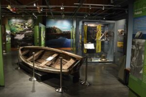 While researching this Ride Guide, we uncovered the area’s deep historical roots and a bygone lifestyle that’s difficult to visualize today. To explore this rich history further, we suggest visiting the Coos History Museum in Coos Bay. There, you’ll discover the local heritage of mining, logging, and shipbuilding. You’ll hear tales of times when rivers served as roads and when Myrtlewood was used as currency during the Great Depression. You don’t need to make it a long visit, 30 minutes is well worth your time. Go!
Videos
The Ride! Double Go!
A quick 2+ minute video of what to expect on your ride and (short) hike to Golden and Silver Falls.
Keep it Local! Learn More

Related Guidebooks
Ridden and Reviewed by:


 Behind every route is scouting, mapping, storytelling, and a whole lot of pedal power.
Have you ridden this route? Got a question? Join the discussion!