Dooley Mountain Climb


Caution! We do not provide turn-by-turn directions in our GPX files. Those are auto-generated by your bike computer and are usually less than 70% accurate. Learn more.
For help loading a GPX file onto your bike computer, go here.
DownloadHighlights & Remarkable Spots
Trail Creek / ~ Miles 1 to 8

The earliest version of Dooley Mtn Road appears to have followed Trail Creek and passed east of Dooley Mtn. The road was used by gold miners in the late 1800s to transit between the towns of Auburn / Baker City and the mines to the south at Clarksville and Malheur City.
Auburn was a gold-mining boomtown that was once the largest community in Eastern Oregon, located about 5 miles to the northeast of the start of the route. In 1861 gold was discovered in the area, and by September 1862, Auburn had grown into a full-fledged town with over 20 stores and 1000 homes to serve the mining industry. [Oregon Geneology, Oregon Department of Transportation]
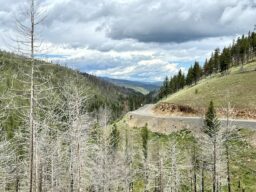
Cornet – Windy Ridge Fire / ~ Miles 1 to 7

Two recent fires have scavenged these hillsides, the July 1989 Dooley Mountain fire and the August 2015 Cornet Windy Ridge fire. Both were lightning-sparked fires. The Cornet-Windy Ridge Fire, the largest in Baker County history, covered 104,000 acres.
Extensive efforts have been made to restore the area. 2017 marked the beginning of a four-year reforestation campaign that put about 1.4 million seedlings into the soil on about 5,000 acres, including plots both east and west of Highway 245 that burned in 2015. The effort cost close to $2 million.
Dooley Mtn Road (Present Day) / ~ Miles 9 to 17
Until the mid-1980s Dooley Mtn road was the major thoroughfare to John Day until the state then constructed Highway 7, a more direct route from Baker city to Sumpter to Bates to John Day. The current day Dooley Mtn Highway is used mostly by local traffic.
Credits & Acknowledgements
Route by Brian Vegter co-owner of the Churchill School – a bike hostel, arts hub, dance hall and high-end Airbnb.
When We Like to Ride This
Late spring for the green and flowing creeks. Fall for the change in colors. But … we wouldn’t hesitate to do this ride in the summer.
Terrain & Riding
A mix of single-lane dirt roads and quiet paved highway. The dirt road is rugged, chunky and steep but rideable. Not super gnarly, but some skill and power are required. Expect continuous gradients of 8 to 12% for the first 1700 feet of climbing; it then tapers off to ~8%. The paved road is downhill at grades of 4 to 6% which is super fun to ride.
Most of the riding is through burnt-out forest lands with pockets of standing green trees. The hillsides are starting to regrow with small sapling trees (circa 2022), but it is mostly tall grasses. Something we find beauty in. The views are wide-open and big. The Elkhorn Mountains to the north, the Burnt River Mountains to the south and in the distance to the northeast, the Wallowa Mountains, the “alps of Oregon”.
The Start
ODOT gravel pit pull-out on the south side of the road at the intersection of Highway 7 and Highway 245.
Food & Water
- None.
Route Notes
We recommend a red blinky light with a review radar detector like a Garmin Varia, for the back half of the paved downhill miles.
The route can be ridden in both directions, but we prefer the direction as mapped. The dirt road downhill section would be a lot of brake grabbing and vibration. Not our favorite.
The remote section is miles 1 to 9. On the other sectors expect light traffic.
Love Where You Ride! Learn More
 To learn more about the mining and logging history of the Baker area we recommend a visit to the Baker Heritage Museum in downtown Baker City.
Videos
The Ride! Dooley Mountain Climb
A quick 2-minute video of what to expect on your ride!
Keep it Local! Learn More
Ridden and Reviewed by:


 Behind every route is scouting, mapping, storytelling, and a whole lot of pedal power.
Have you ridden this route? Got a question? Join the discussion!