Dirty Freehub
Favorites Sign In Search
  • Search
  • Donate
  • Gravel Routes
    • Explore by Region
    • Explore by Type
    • Explore by Collection
  • All Access®
  • Stories
    • Bike Life
    • Culture & History
      • Central Oregon
      • NE Oregon
      • Bend Trails
      • Death Valley
    • People & Places
    • Lands
      • Arizona
      • Central Oregon
      • NE Oregon
    • Love Where You Ride
  • Events
  • User Guide
    • Route Types
    • How We Rate Routes
    • Using the Map
    • Loading a GPX File
    • Glossary
    • FAQs
  • Inside DF
    • The Team
    • Our Missions
    • Impact Reports
    • Press
    • Sponsors
  • Store
    • Gravel Guides
    • Merch
  • Donate
  • Cart
  • Sign In
  • Favorites

Donnybrook

5 Star Route / ~ Madras, Oregon / Published: Oct 2017 / Directions
Save to Favorites Remove from Favorites
Riding out Pony Butte road.
Leading out! / September 2022
Riding up Pony Butte grade, 800 feet of gain.
Pony Butte road leading to Ashwood.
Pony Butte Canyon. Basalt cliffs.
Dead tree with hills behind it.
The rock master (Brian) at the Polka Dot mine.
Weigh your Thundereggs!
Dropping into Ashford. 800 ft descent.
Cows in field, Ashford, Oregon.
Cows!
The self service "store" in Ashwood. Support them!
Leading out of Ashwood. Gravel! ~ mile 16.
Riding gravel roads leading to John Day.
The historic Donnybrook Schoolhouse.
The rolling bald hills of the Oregon backcountry.
The rolling bald hills.
Gravel riders on white road.
Golden fields in the fall in Oregon.
Dead thistle.
Gravel Girl riding up hill.
Paved road leading to Antelope.
Back on pavement, ~ mile 34.
Cyclists on paved road near Madras, Oregon.
Farm building in field.
Bike riders on paved road with rolling hills.
Flat paved road view from handlebars.
Riding Highway 97.
Use caution on the highway!
The parking area at Pony Butte road.
The parking area.
Gravel Girl's ride metrics for the Donnybrook ride on Dirty Freehub.
Gravel Girl's ride metrics.
*
Route:
Loop | 54 mi
*
Gain:
4,400 ft
*
Surface:
35% gravel road, 65% paved
*
Technical Difficulty:
Easier
*
Navigation:
Straightforward
*
Locale:
Remote
*
Tire Suggestion:
40 mm+
*
Options:
---

Crickets. Just you and the crickets are what you expect to find on this ride. Along with the abandoned Donnybrook schoolhouse (built in 1914), a scenic canyon, big views of the mountains, and the abandoned town of Ashwood.

Read More
Map
Brown = gravel / dirt road
Blue = single track
Red = paved road
Purple = paved bike path
GPX Download   Version 1.0

Highlights & Remarkable Spots

Priday Ranch / ~ Miles 46 to 51

Priday Ranch

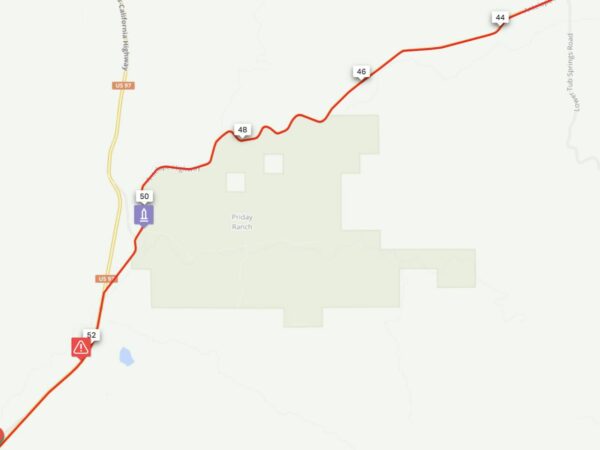
As your riding, to your left. Priday Ranch is a 4,660-acre Preserve on Trout Creek. The Ranch protects ten miles of Trout Creek, Antelope Creek, and Ward Creek, rugged canyons, and native grasslands. The property is home to numerous wildlife species, including steelhead, nesting golden eagles, mule deer, Rocky Mountain elk, and beaver. (Click image for expanded view.) [Deschutes Land Trust]

Ride Details

When We Like to Ride This

On a sunny day with light winds.

Terrain & Riding

From the start, the climbing begins — 2000 feet in 11 miles, 800 feet in the first 3 miles. At the 3-mile mark, you enter a scenic “canyon” that lasts for several miles. By mile 10, you have climbed 2000 feet with big, expansive views. Also, at this point, you will get a bit of reward by descending 800 ft in 2.5 miles.

At mile 15, just after Ashwood, the gravel begins …. and more climbing….and more big, open views. The gravel is good, firm and small. Not too much washboard. But the climbing can be steep, up to 8% gradients. By mile 21, you have climbed 3000 ft, and the gravel road turns to something like cobblestone – softball-sized rocks embedded into a clay base to give a firm but bumpy road surface.

At the Wasco county line (mile 28), the “cobblestone” gravel ends, and the gravel becomes loose and thick. Luckily this section is mostly downhill. Just when you are about to “cry uncle” the gravel ends and the pavement begins. 20 miles of good pavement with an elevation loss of 1600 feet. Yes, there are a couple of small “kickers” left and a lot of great views!

The Start

Lat / Long: 44.784868, -120.960596

A gravel lot on the east side of US 97 at the intersection with Pony Butte road.

An alternate start is in the town of Antelope at the Antelope Market. This is a great starting point if coming to the ride from the north via Highway 97; at the town of Shaniko take State Highway 218 for 8 miles to Antelope. (Lat/Long: 44.910725, -120.723187)

Food & Water

  • ~ mile 15 / Ashwood (self help kiosk)
  • ~ mile 38 / Antelope Market (self help kiosk)
Notes & Options

Route Notes

  1. We recommend a red blink light with rear looking radar detector like a Garmin Varia, especially for the last several miles along the highway. Use caution!

  2. The technical difficulty (i.e. riding skill needed) for this route is easier. The gravel roads are usually in good shape, hard-packed and smooth. But … that doesn’t mean the ride is easy. Take a careful look at the mileage and gain. It is a climber’s route!

Comments

Have you ridden this route? Got a question? Join the discussion!

Keep it Local! Learn More

e-bike charging station Antelope, Oregon

Antelope Market

The Antelope Market is back up and running again! New owners have purchased the old market and adjacent lot. They are busy restoring the grounds and market and are doing a bang up job! We stopped in to visit them in June of 2023. They currently offer dry camping with porta-potty, an e-bike charging station and bike wash. They also have a self help kiosk fridge with cold drinks and popsicles. And best yet, they are gravel cyclists and 6th generation ranchers of the area. We highly encourage that you make the stop on your ride or start your ride from the Antelope Market.

Ridden and Reviewed by:

KevinE

KevinE / Team Dirty Freehub

He should have “Never Stop Exploring” tattooed on his chest! He loves adventures on bikes and is a Co-Founder of Dirty Freehub.

LindaE (aka Gravel Girl)

LindaE (aka Gravel Girl) / Team Dirty Freehub

She loves a good day of gravel, like most people like a good book. She’s always amused by the outdoors and the wild adventures. Gravel Girl is a Co-Founder of Dirty Freehub.

Explore Similar Routes:

Geology

Sign Up for the Dirty Freehub Newsletter

info@DirtyFreehub.org
Terms of Service Privacy EEO Policy Our Values
Dirty Freehub is 501(c)3 non-profit organization.
©2025 Dirty Freehub :: All Rights Reserved :: Website Design
Cleantalk Pixel

We Need Your Support!

Dirty Freehub is a 501(c)3 nonprofit funded by generous donations from riders like you!

  • $25 Keeps the lights on (web hosting, technology tools, insurance, etc.)
  • $50 Keeps lights on + up to date route conditions
  • $100 Continued route development
  • $200 Fully documented route guide
  • $200+ Gravel Girl giggle of gratitude

Donate Today