Dichotomy


Caution! We do not provide turn-by-turn directions in our GPX files. Those are auto-generated by your bike computer and are usually less than 70% accurate. Learn more.
For help loading a GPX file onto your bike computer, go here.
DownloadHighlights & Remarkable Spots
Weed-Whacker Hill / Primitive Dirt Road / ~ Miles 0 to 6
From the start, the route rolls out along hard-packed gravel roads, until ~ mile 2.6. Here is the last house along the road and maybe a couple of dogs. For us, they were friendly but unleashed.
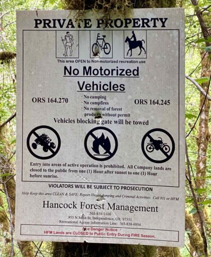
Just after, the road becomes a double track with a grass-filled median. Over a 2 mile stretch, the average gradient is 12%. The total elevation gain for the “weed-whacker” climb (the name will become obvious when you do the route) is 1500 feet over 3.5 miles. This is private land with recreation access granted.
Weyerhaeuser Rough / Gravel / ~ Miles 6 to 11
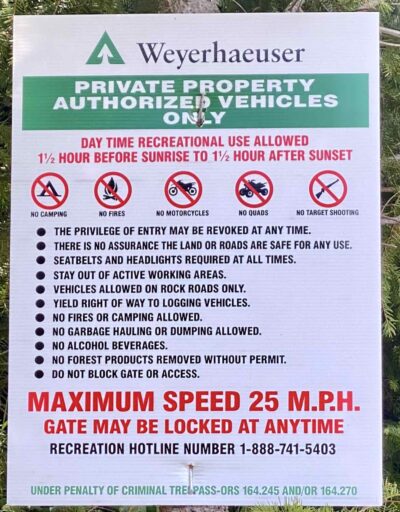
The top of the climb is marked by a Weyerhaeuser sign and the sudden openness. Most of the area has been recently logged, but this opens up great views of the Coast Range.
The Oregon Coast Range extends over 200 miles from the Columbia River in the north on the border of Oregon and Washington, south. It is 30 to 60 miles wide and averages around 1,500 feet in elevation. The oldest portions of the range are over 60 million years old.
The climate is cool, with dry summers followed by mild and wet winters. The majority of precipitation accumulates in the form of rain, with snow during the winter months at the higher elevations, but no permanent snowpack. Annual precipitation varies from 60 inches to up to 120 inches. [Wikipedia]
If you happen upon a log truck, please yield right of way by stopping and putting a foot down. Again, this is private land with recreation access granted. The Weyerhaeuser roads are the roughest and most coarse gravel roads of the day.
C2C Trail / Primitive Single Track / ~ Miles 11 to 14.5
The Corvallis to the Sea (C2C) trail sector begins just after mile 11 with a left across two graded berms. The trail is old school, Jurassic Park, single track. Narrow, grassy, almost grown over. However, the brush along the old road was cut back significantly to yield a clear path. The trail is mostly down and steep (8 to 12%), but there is one tough, short uphill. Be warned; there are several drainage ditches cut perpendicular to the trail. Coming into one of those unaware and at speed could be bad.
The Corvallis to the Sea Trail (C2C) is a 60-mile hiking and biking trail through the Oregon Coast Range that connects the Heart of the Willamette Valley with the Central Oregon Coast. The trail is located within the traditional homelands of the Ampinefu or Marys River Band of Kalapuya, Wusi’n or Alsea People, and the Yaqo’n or Yaquina People. [Corvallis to the Sea Trail]
Gopher Creek / Gravel Roads / ~ Miles 14.5 to 20
Exiting the single track, you pop unexpectedly onto a gravel road. The next 6 miles are “flattish” and fast; the gravel is hard-packed, the woods are thick and green around you. The road follows Gopher creek; however, it will not be evident at first. Along the way, you come to a couple of out-buildings that border both sides of the road. There was a “No Trespassing” sign that hints that the ride is private. It is not; the road is public! And there’s just a touch of pavement in the middle of nowhere.
NF 31 / Paved / ~ Miles 20 to Finish
At mile 21.5, the road begins to climb, nothing like at the beginning of the route but enough to capture your attention. The road climbs, rolls, and then climbs. Most of the climb is paved.
Just before mile 26, the route tops out. Get ready for a fun, sweeping downhill for 4 miles at a 4% average gradient. The road then transitions back to gravel, and it is an easy spin back to the start.
Credits & Acknowledgements
Thanks to NelsonB, of the Mid-Valley Gravel Grinders Facebook group, for bringing this area to our attention through his great maps.
When We Like to Ride This
The route needs time to dry out. Thus, we recommend riding this mid-spring or later. We did this ride in mid-May, and it was perfect. Everything was green and lush and not too wet.
Terrain & Riding
The first half of this ride is the crux! Steep, coastal technical. The second half is almost all Cadillac gravel.
The Start
Big Elk Campground. Pit toilets. Water. We parked at one of the campsites and paid the daily fee. If parking multiple cars, leave a note on your window stating that you are paying for the use of the site for parking.
Food & Water
- None.
Route Notes
40 mm tires or larger. We recommend larger, especially if the ground is moist and soft, but a strong technical and fit rider will manage with 40 mm tires. For our group of four, we all had tires of 50+ mm.
Do this ride with long socks and long arms. The brush in the first half will reach out and grab you, and some of it is stinging nettles. With proper protection, you will not have a problem.
The RideWithGPS elevation summary under-reports the total elevation. The total gain for the day will be 3800 to 3900 feet.
We recommend riding the route in the direction mapped. Riding the single track in the opposite direction would be very, very demanding.
Miles 3 to 10 are on private logging properties (Hancock Forest Management and Weyerhaeuser). Access is permitted for biking but not for motorized vehicles. Also, if the roads are posted closed due to logging activities, please respect this request. It is better to find another ride for the day than to lose access to these lands for riding. If you encounter a logging truck during the ride, we highly recommend stopping and putting a foot down to let the truck pass safely.
Route Options
There are two bail-out points. The first, just before the start of the single-track, the second, at the end of the single-track. For each of these bail-outs, proceed north and intersect the original route in ~ 2 miles.
Get Involved!
This route would not be possible without the Corvallis to the Sea (C2C) Trail connector and the recreation access granted by Hancock Forest Management and Weyerhaeuser.
(a) We encourage you to take a moment and learn more about the C2C Partnership and their work.
(b) We also encourage you to call Hancock Forest Management (503-838-1610) and write a quick email to Weyerhaeuser (northwestadmin@weyerhaeuser.com) expressing your support for recreational land use by bicycles. (Use the term bicycles not bikes, bikes can be mistaken to mean motor bike.)
Videos
The Ride! Dichotomoy
A quick 2-minute video of what to expect on your ride!
Ridden and Reviewed by:


 Behind every route is scouting, mapping, storytelling, and a whole lot of pedal power.
Have you ridden this route? Got a question? Join the discussion!