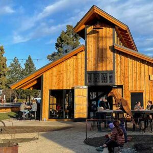
Cowboy Preacher
Closed: Due to the Flat Fire of August 2025. Sectors heavily burned.
Attention: Winter Mule Deer Migration Area – We Recommend No Cycling from December 1 to March 31


Caution! We do not provide turn-by-turn directions in our GPX files. Those are auto-generated by your bike computer and are usually less than 70% accurate. Learn more.
For help loading a GPX file onto your bike computer, go here.
DownloadHighlights & Remarkable Spots
Camp Polk Meadow / ~ Mile 3.5
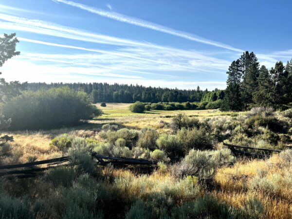
This area has been a historical crossroads for people for thousands of years. First the meadow supplied plentiful food and water for generations of Native American tribes.
Then, it became a hub when explorers, soldiers, entrepreneurs, and settlers. In the early 1800s, the Hudson’s Bay Company and the fur trade brought trappers in search of beaver. In the early 1840s, John Fremont’s expedition crossed the high desert and camped in the vicinity of Camp Polk. By 1855, railroad survey parties were seeking westward routes. Lieutenants Williamson and Abbot traveled through the area scouting routes. From September 1865–May 1866, Captain Charles LaFollett commanded 42 soldiers who were sent to establish Camp Polk with orders to protect commerce and settlers on the Santiam Wagon Road. [Deschutes Land Trust. Camp Polk Meadow: A Historical Crossroads]
Camp Polk Historic Cemetery / ~ Mile 4
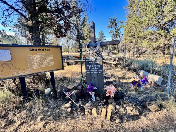
A bit further down the dirt road past the historic Camp Polk buildings is the Cemetery. The earliest grave site here is from July 8, 1880. The first first settlers of the Camp Polk Meadow, the Hindmans (pronounced Hineman) are also buried here. They built their homestead circa 1870. The Hindman’s maintained the Santiam Wagon Road and managed the Hindman Station – a store, a post office, and a place to house travelers. Today, the cemetery is an eclectic mix of early settlers to those recently deceased. [On-site kiosks]
Willow Springs Preserve / ~ Mile 6.5
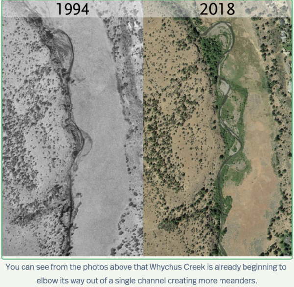
Historically, Whychus Creek was a mixture of narrow canyon stretches and well-vegetated meadows where the creek could spill over its banks. This diversity provided habitats for fish to spawn, rear, and hide. Streamside vegetation provided cover for wildlife and helped maintain cool stream waters. However, with development through the 1990s this diversity and quality habitat was lost. In 2016, the Deschutes Land Trust and its partners began a multi-year effort to restore the Whychus Creek. The Wills Springs Preserve is part of this project and the restoration work continues today. Learn more here.
Three Sisters / ~ Mile 9
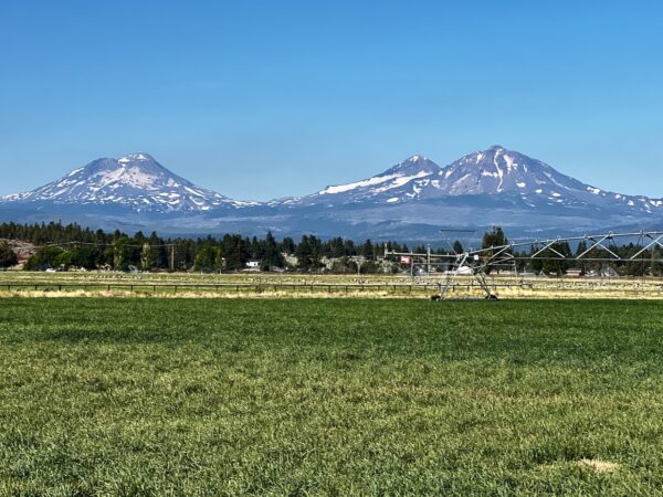
Did you know that these volcanoes did not form at the same time and are not of the same structures? Wow!
South Sister (left), also known as “Charity”, is the tallest volcano of the trio, standing at 10,363 feet. It is a predominantly rhyolitic stratovolcano overlying an older shield structure. Its modern structure is no more than 50,000 years old, and it last erupted about 2,000 years ago.
Middle Sister, also known as “Hope”, is a basaltic stratovolcano . It began eruptive activity 48,000 years ago, and it was primarily built by eruptions occurring between 25,000 and 18,000 years ago.
North Sister (right), also known as “Faith”, is the oldest and most highly eroded of the three volcanoes, with zigzagging rock pinnacles between glaciers.It is a shield volcano that overlays a more ancient shield volcano named Little Brother.The oldest reliably dated lava flows on North Sister have been dated to approximately 119,000 years ago.Estimates place the volcano’s last eruption at 46,000 years ago.[Wikipedia]
Whychus Canyon Preserve / ~ Mile 11.4
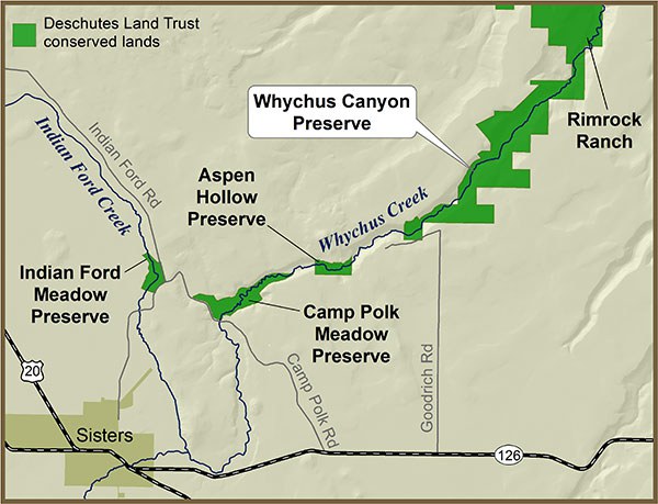
This is a short detour to the north by about 1.5 miles.The Preserve is 930 acres on Whychus Creek. It was first established in 2010 and an additional 480 acres was added in 2014. The Preserve contains four miles of Whychus Creek, high quality grasslands, old growth juniper, cottonwood and aspen stands. The Deschutes Land Trust’s restoration efforts at the Preserve have been focused on restoring the forested areas to a healthy, open ponderosa pine/juniper savanna that provides high quality wildlife habitat. They are currently working with their restoration partners to restore six miles of Whychus Creek from the Whychus Canyon downstream through Rimrock Ranch. Learn more about the creek restoration here.
Martin Boer Goat Farm / ~ mile 15
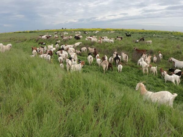
The Boer or Boerbok goat is a South African breed of meat goat. It was selectively bred in the Eastern Cape from about 1920 for meat qualities and for the ability to survive by grazing on the thorny grasslands and bushes.
In Central Oregon Boer goats are being used for weed abatement and fire prevention. The advantages of using goats are versatility, cost effectiveness, environmentally green, less noisy than mechanized methods, and are highly effective.
Juniper Trees / ~ Mile 19
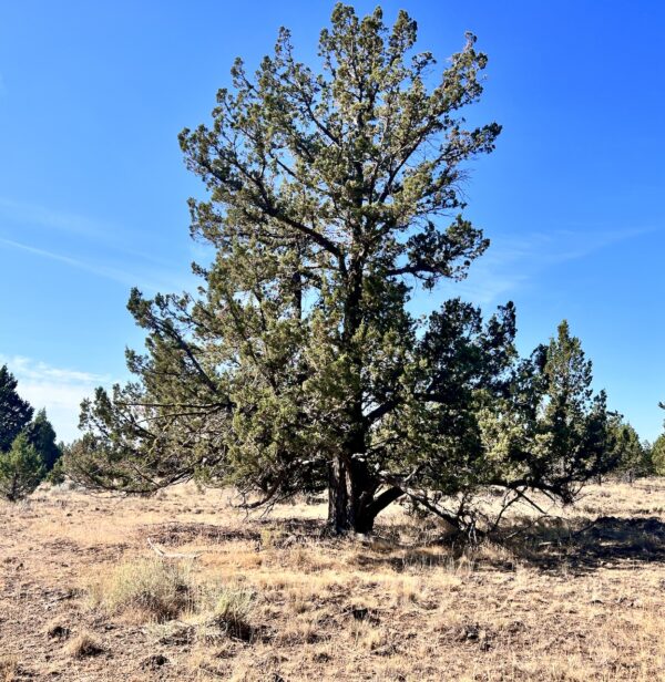
About 95% of the junipers you see here today are less than 100 years old. The Juniper spread with the rise of homesteading in the mid-1800s. Settlers suppressed wildfires and let livestock overgraze native grasses.
In the high desert,which sees less than 16 inches of precipitation per year, a single juniper can use 20 to 40 gallons of water per day! Junipers deplete the soil of water and nutrients from making it difficult for native plants like bitterbrush to thrive – one of the main staples for mule deer in the winter. [On-site kiosk]
Homesteading / ~ Mile 21
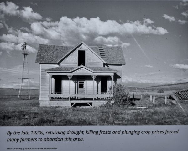
Homesteading on the Winter Range surged in the early 1900s. The U.S. government doubled the Homestead Act’s land grant twice, giving up to a square mile to any adult citizen who agreed to
improve it. “Experts” promoted dryland farming to grow wheat and other crops in arid landscapes.
Settlers swarmed, drawn by open land and promises of crop yields. Over time, the rainfall proved barely enough to survive, let alone raise cash-crops. Harsh winters and poor roads left people trapped.
By the late 1920s, many homesteaders left.
A 1931 windstorm devastated most of the crops and buildings that remained. Some homesteaders sold their land to neighbors or the government. Others just walked away, creating a patchwork of public and private ownership. By the mid-1930s few families remained. [On-site kiosk]
Basalt Columns / ~ mile 22.5
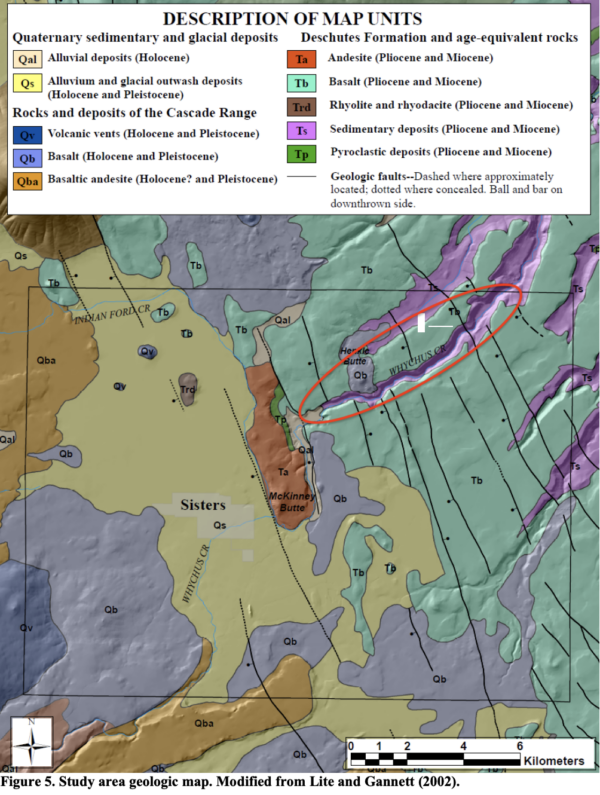
As you drop into the canyon down to Whychus Creek you pass through a unique area of geology. The oldest rocks exposed in the study area are basalt flows (lava), sedimentary
deposits, and pyroclastic flows (or see this video) of the Deschutes Formation (Volcanic debris
from Cascade Range volcanism that filled the Deschutes Basin between Bend and Trout Creek 12 and 4 million years ago). The Deschutes Formation sedimentary deposits (Ts) underlie Deschutes Formation basalt flows (Tb), and are only exposed where modern drainages have incised through the basalt. [“Geology and Geomorphology of the Lower Deschutes River Canyon, Oregon”. Beebee, O’Connor, Grant]
Whychus Creek Crossing / ~ Mile 23.5
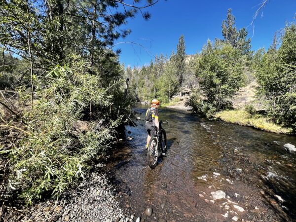
Whychus Creek is a tributary of the Deschutes River. In the early and mid 2010s parts of this river not only had no fish, it had no water. Irrigation withdrawals, land use changes, and dams had combined to eliminate the thousands of steelhead and Chinook salmon that once started and finished their lives in that creek. In the last fifteen years, however, a gradual shift has occurred in the Whychus Creek area and also in much of the Deschutes Basin: a coalition of landowners, citizens, nonprofits, private companies, and government agencies have come together to restore the creek as a home for migratory fish. [Oregon Explorer]
Grandview Fire / ~ Mile 25
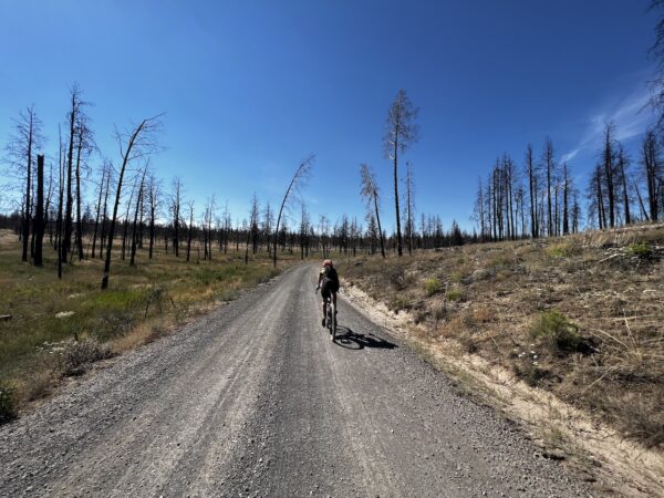
The Grandview Fire, which began on July 11, 2021, burned more than 6,000 acres. It burned mostly on the Crooked River National Grassland. some privately owned lands under the protection of the Oregon Department of Forestry and some Deschutes Land Trust managed lands.
The result? All of those burned acres, especially those by the road, heighten the possibility of burned trees falling and causing harm.
“…it is important for us and the safety of our community to make sure that we balance leaving those natural snags and those fire impacted trees but also to make sure we’re not putting our communities and our folks at risk,” Rika Ayotte, Executive Director of the Deschutes Land Trust.
According to the Forest Service, humans are at fault for more than 150 fires every year in central Oregon. [Central Oregon Daily]
When We Like to Ride This
From mid-June, through summer, into fall.
Whychus creek, which you must cross, can run strong early in the year. Use caution when crossing, the currents can be stronger than anticipated. We had an incident of a rider falling and being swept downriver ~ 100 yards. This is not a creek you can ride through.
A good predictor of the water level and flow is provided by the USGS upstream gauging station (#14075000). Flows in excess of 200 cfs are significant and relate to about 32″ deep of water and strong flow. Passable but with caution. Flows less than 160 cfs relate to about 18″ deep of water and moderate flow. A pretty straightforward crossing.
Terrain & Riding
The Rural Sector / Miles 0 to 18
Ranches, hobby farms, and agriculture … what Central Oregon used to be. Green fields of hay. Creeks, streams, and nature preserves. Big views! Mostly paved (or fast, hard-packed gravel).
The National Grasslands Sector / Miles 18 to 26
This is the crux of the ride. It starts out with quick climb on solid gravel, but by mile 19 the road becomes dirt and much more demanding. From rough, to chucky, to hardscape, to loose and dusty. All rideable. The views by far make up for the technical demand.
After crossing Whychus Creek, you grunt up a bit of a hill, but from there it is a good dirt road meandering through the Grandview burn. Charred trees and lush grasses.
Cadillac Sector / Miles 26 to Finish
Fast & Woody. Cadillac gravel. Is this gravel? Views of The Sisters. Slightly uphill, 1 to 3%. Pop up short hills, get pavement, big views.
The Start
Cliff Clemens park in Sisters. Water. Flush Toilets
An alternative spot to park, that we really like, is at Camp Polk Meadow Preserve, managed by the Deschutes Land Trust. The parking lot is small, thus we recommend a maximum of 2 cars. Further, we recommend a parking donation of $10 per car. (Why do we make this ask? The Deschutes Land Trust is a nonprofit, but nonprofit does not mean free. They have maintenance and management costs with this historic property. Please considering supporting them.). Lat/Long: 44.323398, -121.520122
Food & Water
- None
Route Notes
For more information on the Flat Fire of 2025, see this Facebook page.
We recommend a red blinky light with rear looking radar detector, like a Garmin Varia, for the paved sectors. In general, the paved roads are quiet county roads, with little traffic. Margins will vary. Ride single file. Avoid at peak times of day.
Please be aware that this route serves as a critical winter mule deer migration area between December 1 and March 31. In the best interest of the wildlife, we kindly request that you refrain from cycling during this period. Your cooperation is highly appreciated.
Version 1.0 of this route, up to July 2023, was named Catch & Release. We have since, changed the start location and added a lot more information on the culture, history and heritage of the area.
There is no perfect tire for this ride. Paved, fast cadillac gravel, and dirt road chunk.
Love Where You Ride! Learn More
 The lands your ride on today were once home to the Warm Springs and Wasco tribes. In 1855 they were forced to cede about 10 million acres of land to the federal government in exchange for exclusive use of the Warm Springs Reservation. However, they reserved the rights to hunt, fish and gather within the ceded lands and at usual and accustomed stations. In 1879 many Northern Paiute joined and in 1938, these three distinct groups formed the Confederated Tribes of Warm Springs. Learn a lot more of the history at the Museum at Warm Springs or give this article from The Source a read.
Videos
The Ride! Cowboy Preacher
A quick 2-minute video of what to expect on your ride!
Pyroclastic What??
In this short 2-minute learn what a pyroclastic volcanic flow is. This super-cool video that made us a bit smarter.
Fire, Weeds, & Goats
Yep, goats can be a super-useful tool in clearing weeds and building defensible spaces for fire safety. And they are versatile, cost effective, environmentally green, less noisy than mechanized methods, and highly effective. Learn a bit in this 1-minute video.
Podcasts
Controversial Juniper Trees
The juniper tree is an iconic tree across Central and Eastern Oregon and yet, in some places they are being removed. Find out the real scoop about this unique tree from Gena Goodman-Campbell who is the Stewardship Director at ONDA (Oregon Natural Desert Association) where she works to engage [...]
Keep it Local! Learn More
Ridden and Reviewed by:


 Behind every route is scouting, mapping, storytelling, and a whole lot of pedal power.
Have you ridden this route? Got a question? Join the discussion!