Cape Meares / Bayocean Road


Caution! We do not provide turn-by-turn directions in our GPX files. Those are auto-generated by your bike computer and are usually less than 70% accurate. Learn more.
For help loading a GPX file onto your bike computer, go here.
DownloadHighlights & Remarkable Spots
Cape Meares Lighthouse / @ Start
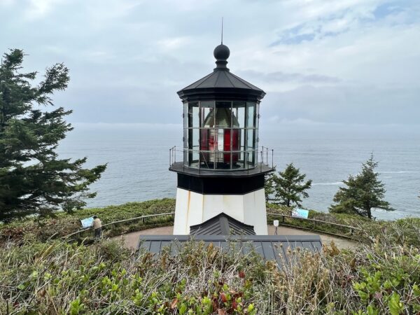
Cape Meares, first charted in 1788 by Captain John Meares, proved an ideal lighthouse location. Constructed below the fog line, it ensured visibility in critical conditions. The lighthouse, though the shortest on the Oregon coast, began operation on January 1, 1890. It boasted a powerful first-order Fresnel lens, one of the most powerful and largest of its time. This kerosene-powered lens produced distinctive red-and-white flashes visible up to 21 miles away. In 1963, the original light was replaced by an automated beacon, marking the end of an era. [Oregon State Parks]
Big Spruce / @ Start
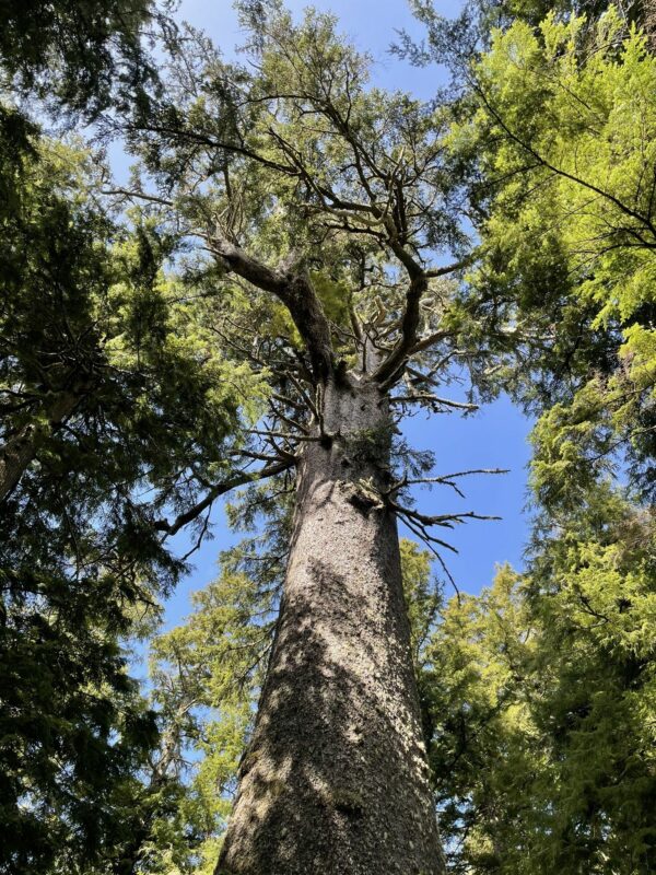
In an impressive patch of ancient Temperate Rainforest on the Cape Meares headland stands Oregon’s largest spruce. In 2008 it measured 144 feet tall with a broken top and over 48 feet in circumference.
The broken top is not surprising, as the tree has undoubtedly experienced hundreds of storms with wind gusts over 100 mph in its lifetime. In a forest like this the trees shelter each other from the wind, and any that grow significantly taller than their neighbors are at great risk of broken tops.
Learn at lot more about this tree here.
From the parking area follow the trail southwest (0.1 miles).
Octopus Tree / @ Start
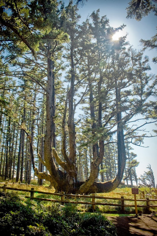
The Octopus Tree (follow a short hiking trail east of the lighthouse) is a massive Sitka spruce located a few hundred feet from Cape Meares Lighthouse. The tree is shaped like an inverted octopus with branches growing like giant tentacles from its 50-foot base. The tree has no central trunk. Instead, six candelabra limbs extend horizontally from the base as much as 16 feet before turning upward. The Octopus tree is believed to be two hundred to three hundred years old dating back to when the Indians lived in the area.
In fact, one theory says that the Octopus Tree was shaped like an octopus by the Indians to hold canoes with corpses in a practice known as “tree burial.” Another theory is that the shape comes from the ravages of the wind.
Bayocean Townsite / ~ Mile 4
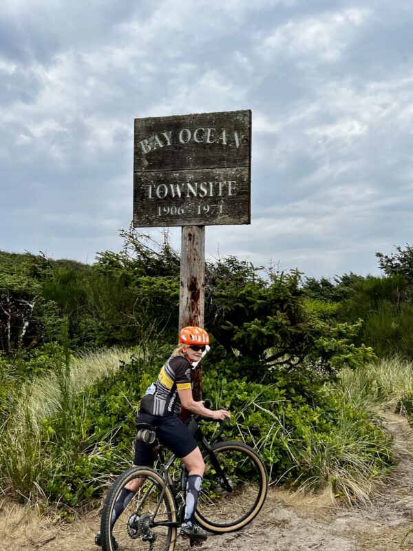
Bayocean is the town that fell into the sea. It was planned in 1906 as a resort community on Tillamook Spit, a sandy strip of land on the ocean side of Tillamook Bay. Its post office was established in 1909, and by 1914 the resort town had a population of over 2,000 people.
Bayocean’s named derived from views of Tillamook Bay and the ocean on either side. From the outset it was intended as the “Atlantic City of the West.” The town had a dance hall, hotel with an orchestra, 1,000-seat movie theater, shooting range, bowling alley, tennis courts, a rail system, and four miles of paved streets. Bayocean’s crown jewel was a heated natatorium with wave generators and a bandstand for live music while guests swam.
Most residents and tourists arrived via T. B. Potter’s steamship, the S.S. Bayocean. She was the largest yacht on the coast, and took three days to make the trip from Portland. The final leg of the journey entered the unprotected mouth of Tillamook Bay and proved a rough and often frightening experience.
Tillamook Bay / ~ Miles 3 to 13
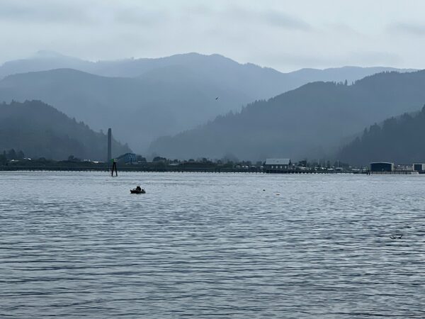
As you ride, Tillamook Bay is on your right. The bay is bordered by Garibaldi to the north, Tillamook to the south, and Bayocean Peninsula to the west.
This area was originally home to the Tillamook (or Killamook) people, who spoke a Salish language. From 1824 to 1829, the tribe faced deadly smallpox epidemics. This new disease, introduced by European contact, devastated the population as they lacked immunity. The arrival of Oregon Trail settlers in 1841 led to conflicts over land and resources, further reducing their numbers. By 1849, the Tillamook population had dwindled to an estimated 200 people.
Bayview Jetty / ~ Mile 8
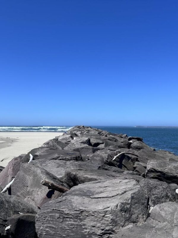
Bayocean’s residents asked the Army Corps of Engineers for a protective jetty to reduce the waves at the mouth of Tillamook Bay to make the boat transit to Bayocean less frightful. The Army studied the location and suggested that two jetties be built, one on each side of the bay’s mouth, at an estimated cost of $2.2 million. The Army Corps would secure funding for half the cost, but the other half was required to come from local residents. With the multimillion-dollar price considered unaffordable, Bayocean’s residents only built a single jetty (the south one) for a little over $800,000.
The single jetty worked for a time, and made for a much smoother journey into the bay. An issue arose when the one-sided change to the coastline began a process of erosion that ate away Bayocean’s beaches. They narrowed for a time, before the sea completely overtook them. It was the beginning of the end.
Bayocean Dike / ~ Miles 12.7 to 13.3
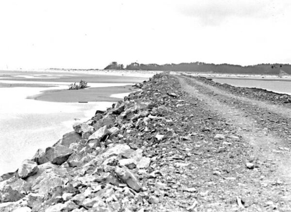
In 1928 a road finally was opened between the mainland and Bayocean Peninsula. But disintegration of the resort developments had already begun, with winter storms pounding against the peninsula’s seaward side.
1939 – First breach on Bayocean Peninsula.
1942 – Erosion continued. Second breach.
1952 – Grand blow-out breach, mile-wide gap.
The connecting dike we see today, pictured, was built in 1956.
Credits & Acknowledgements
This ride guide was funded in part by the Oregon Coast Visitors Association.
Terrain & Riding
Cape Meares Road / Miles 0 to 2.4 and 13.4 to Finish
- This sector is characterized by classic north coast forest: Sitka spruce, hemlock, Western Red Cedar, sword ferns and thick undercover.
- Miles 0 to 1.2 are on the old abandoned road that has been decommissioned due to land slippage. There may be a two places where you need to walk over an embankment.
- Starting at mile 0.8 you begin a downward descent to the waters at a 6.0% average gradient. Total loss is 450 feet.
- @ mile 1.2, you intersect the “new” road.
- Miles 1.2 to 2.4 are a shared road with cars, expect some traffic.
- At mile 2.2, reach the water. Just to your left is Cape Meares lake. At mile 2.4 take a left onto Bayocean Dike Road (gravel). To the right of the dike road is Tillamook Bay.
Bayocean Dike Road / Miles 2.4 to 13.4
- This sector is characterized by a flat 4-mile spit with rolling sand dunes, thick sea grass, shore pine and spruce trees and beautiful views of Tillamook Bay and the Pacific Ocean.
- Miles 2.4 to 7 are a well maintained gravel trail/road only open to non-motorized vehicles. It is easy, flat riding that is highly scenic.
- @ mile 4.4 there is a spur trail to the left. This is the historical Bayocean Townsite trail. You may want to walk it versus ride, it is sandy and almost a tunnel through thick sea grass. It will bring you to a crest where you see the beach sands meeting the Pacific Ocean.
- @ mile 4.7 there is second spur trail to the left. This goes out to a small enclave of eclectic things.
- Beyond Mile 7 and to the jetty, the trail is rough and rugged. It is now a trail, not a dirt road. Closely follow the breadcrumb navigation on your bike computer/navigation device to stay on track. We think this last mile is worth the effort. It is scenic, remote, and peaceful.
- @ mile 7.2, you encounter a sandy wash area that requires a hundred yards of so of hike-a-bike.
- @ mile 8.2 you reach the jetty. From here, we walked and explored for nearly an hour.
The Start
Cape Meares Trailhead parking lot. This is before the turn into the lighthouse. On a non-busy day, we prefer to start this ride at the lighthouse parking area proper. Within the state park, there are flush toilets (~ 0.5 miles).
Alternate Start / All Access
Lat/Long: 45.519478, -123.947573
Just past the intersection of South Fork Road and NF-47 / South Fork John Day Road. Take South Fork Road southwest for 0.25 miles. Just after crossing the South Fork of the John Day river, there will be a turnout to your left back to the river.
Food & Water
- None
Route Notes
If you do the spur trails, we recommend long, knee high socks. The grass grows tall and thick.
A tire width of 40 to 55 mm works. The wider the tire, the less walking through sand.
We recommend a full day to do this ride. Don’t hurry it. Get off your bike, walk around, take pictures. Bring a bike lock, bring adequate walking/biking shoes. Maybe put flat pedals on your bike. There is so much to see and do! This is meant to be a day of exploration and discovery, not head down fast pedaling.
Route Options
Shorter / All Access
Start at the Bayocean Dike Road parking area. This option is a ride of just the Bayocean Spit. A very flat and technically easy ride.
At mile 7 on the map (or mile 3.7 if starting from the alternate / all access parking area), the road becomes more primitive and rugged. From here, you can either continue all the way to the jetty or turn back. The terrain remains flat, but you’ll need to walk through a sandy section. In our view, the trip to the jetty is well worth it!
Videos
The Story of Bayocean
This 30-minute OPB (Oregon Public Broadcasting) video explores the history of the township that intended to rival Atlantic City but fell into the Pacific Ocean.
Keep it Local! Learn More
Related Guidebooks
-

All Access Gravel Guide Eastern Oregon (Collector’s Edition!)
$12.50Now shipping! A 64-page pocket-sized gravel guide. Featuring gravel routes, art, culture and local history. A one of a kind…Add to cart -

All Access Gravel Guide Western Oregon (Collector’s Edition!)
$12.50Now shipping! A 64-page pocket-sized gravel guide. Featuring gravel routes, art, culture and local history. A one of a kind…Add to cart
Ridden and Reviewed by:


 Behind every route is scouting, mapping, storytelling, and a whole lot of pedal power.
Have you ridden this route? Got a question? Join the discussion!