Building Bridges


Caution! We do not provide turn-by-turn directions in our GPX files. Those are auto-generated by your bike computer and are usually less than 70% accurate. Learn more.
For help loading a GPX file onto your bike computer, go here.
DownloadHighlights & Remarkable Spots
Wallowa (the town) / @ start
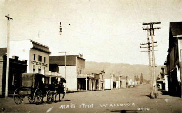
The name Wallowa comes from a Nez Perce word referring to a triangular structure of stakes that supported a network of sticks, called lacallas, used to create a fish trap. The Nez Perce placed these traps in the Wallowa River just below the outlet of Wallowa Lake. According to Lewis A. McArthur, author of Oregon Geographic Names, the origin of the name is debated. However, he gives significant weight to Levi Ankeny’s account, as Ankeny was well-versed in the early history and traditions of the Wallowa Valley and had close relationships with many Nez Perce who knew the true origins of the name. Picture – Main Street Wallowa 1910. [Wikipedia]
Wallowa Cemetery / ~ mile 2
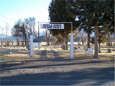
The Wallowa Cemetery, also known as the Catholic Cemetery, is recognized as an Oregon historic cemetery, preserving the legacy of early settlers
Take the time to wander the grounds; you’re sure to see gravestones from the late 1800s!
Wallowa Mountains / ~ mile 7
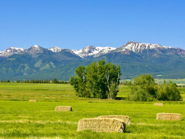
The Wallowa Mountains, often called the “Alps of Oregon,” have the most complex and extensive geological history of any range in the state. Unlike the volcanic Central Oregon Cascades, the Wallowas are a striking mix of granite and limestone, shaped by ancient seabeds, tectonic shifts, and glacial activity. This diverse geology has created dramatic alpine landscapes, deep canyons, and rugged peaks. The range also contains remnants of prehistoric coral reefs, a testament to its deep oceanic origins over 250 million years ago.
Learn how to “untangle what you see” in this podcast with geologist Dr. Kim Ely.
Old Homesteads / ~ Mile 11

Along the route you will see some mature, gnarly, weathered apple trees. In later summer they are populated with smallish red apples. These trees are usually indicative of homesteads from the late 1800s early 1900s.
Joseph Branch Trail / ~ miles 14 to 20
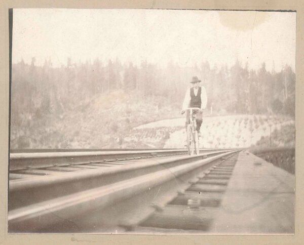
The Joseph Branch Trail-with-Rail Consortium is “developing a non-motorized trail alongside the existing railroad tracks (just to the west of the route, miles 14 to 20) within the publicly-owned Wallowa-Union Railroad Authority corridor. Starting in Elgin, the trail winds through the Grande Ronde and Wallowa river valleys, terminating 63 miles later in Joseph. Along the way, the trail connects the small towns of Minam, Wallowa, Lostine, and Enterprise. Love this picture! Click on it to see in full view.
Wallowa River / ~ mile 14
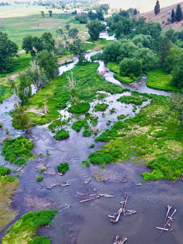
Just downstream from where you cross the Wallowa River, a section of the river’s floodplain was transformed into a thriving ecosystem in the summer of 2022 via a collaborative project between the Wilson-Haun family and Trout Unlimited.
Through intensive efforts, crews dug side channels, placed 500 logs, built 50+ beaver dam analogs, and planted thousands of native trees and plants. This work restored the river’s natural flow, slowing water, replenishing groundwater, and creating essential habitats for salmon, steelhead, lamprey, and other wildlife.
The project’s impact is profound (watch this video). The reconnected floodplain now supports spawning Chinook salmon, increased bird populations, amphibians, dragonflies, and even mammals like bobcats and bears. Game cameras have even recorded a beaver, signaling nature’s return to self-sustaining cycles. Listen to our podcast on the importance of beavers with Maureen Thompson, the Manager of the Beaver Works program at Think Wild.
Nez Perce Historic Site / ~ mile 17.5
At the confluence of the Wallowa and Lostine Rivers, nestled among a stand of cottonwood trees, the Nez Perce manage a weir for fish monitoring and restoration. In 2021, after decades of efforts to improve fish passage past eight major dams, the tribe successfully reintroduced coho salmon to the Lostine River, marking a significant step in restoring the region’s native fish populations.
Nearby, the elder Chief Joseph (Tuekakas), the revered Nez Perce leader, was buried one mile south of the route at approximately mile 17.5.
Do you know that there was an elder and younger Chief Joseph? Learn more here.
Wallowa History Center / @ Finish
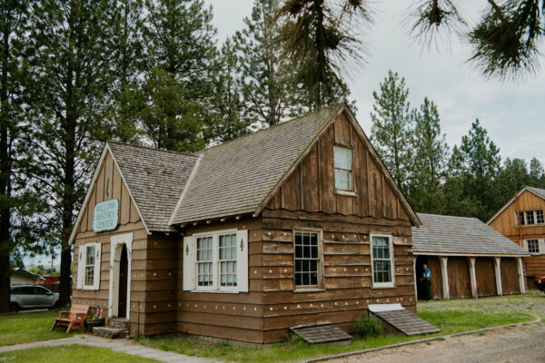
Located in the historic U.S. Forest Service headquarters of the Bear-Sleds Ranger District, this center now features a comprehensive interpretive exhibit showcasing the natural and social history of Wallowa Country. Spanning from Nez Perce times through settlement to the present, the exhibit includes artwork, historic photographs, artifacts, maps, and documents that bring the region’s rich past to life.
When We Like to Ride This
A special time to visit and ride this area is during the Nez Perce Tamkaliks Celebration – (almost) always the 3rd Weekend in July. Enjoy three days of song and dance, culminating in a walasit service and Friendship feast. Descendants, locals, and visitors attend together. Camping and dancer registration is free!
Another great time to ride is late spring when the fields are green and there’s still snow on the mountains. Do not ride when wet, you will be into a muddy, sticky mess!
Terrain & Riding
Riding this route in a clockwise direction gives you a nice climb up into the hills with a long, slow descent. Mostly gravel, the route finishes with a nice ramble along the Wallowa River.
You will encounter a mix of terrains from rolling grassy hills, to the pristine Wallowa valley, to basalt outcroppings, and farmlands. You are also rewarded with distant views of the Wallowa Mountains.
Miles 3.5 to 9.5 are the crux of the route. It is a single lane primitive dirt road with sector of embedded and loose gravel/rock and areas that can be deeply rutted. However, it is all rideable. Along this sector is the one significant climb of the day. The first pitch of the climb gains 800 feet, then a short break given, followed by a final short pitch that is steeper (~ 10%) and more rugged.
The good news … all the gravel before and after this is Cadillac gravel – fast and smooth!
The Start
The Wallowa City park. Flush toilets. Water.
Route Notes
The roads you will be riding are working farm and ranch roads. Make sure to give way to those who are working hard to put food on your table! That may mean “skinnying-up” single-file or even stopping to let a piece of machinery by. To learn more about visiting and riding in rural farming and ranch country give a listen to our podcast “Tractors, Bulls and Lycra“.
When riding gravel, it can be noisy and difficult to hear vehicles behind you, especially in a rural setting like this. Thus, we recommend a rear-looking radar device like a Garmin Varia. Using your bike computer, it helps you see traffic behind you.
Each year in July, the annual Tamkaliks Celebration and Friendship Feast is held. It has influenced generations of Nez Perce and Wallow valley locals to connect as neighbors, friends, and fellow stewards of this beautiful place we all call home. The pedestrian footbridge (mile 0.5) forms a tangible connection between the community of Wallow and Nez Perce returning to their homeland.
Camping. You can camp at the Nez Perce Wallowa Homelands by contacting them at the Homeland Project office, 541-886-3101 or tamkaliks@gmail.com. Also, the Wallowa River RV park is adjacent to the Nez Perce Wallowa Homelands.
Warning! You may encounter puncture vines / goatheads on this route. These “buggers” will stick into and through your tires. They are most prevalent late summer and early fall. The thorn is woody and super sturdy. Here is our best advice:
- use only tubeless tires.
- top off your sealant before the ride.
- carry extra sealant and a valve core remover with you. You may need to re-add. Plugs are not a great option. You will run out of plugs before you get all the holes sealed. Only use on goathead punctures that are not sealing.
- if they embed themselves into your tire, leave them. If you pull them all out at once you will have too many holes for your sealant to fix. It will be a big fail!
- the thorns break off and embed themselves into your tire. If you have a sidewall failure on future rides and plan to use a tube, it will not work. The embedded goatheads will immediately puncture the tube.
- the solution, use CushCore or something similar. With CushCore, you can ride a tire with no air and if careful, suffer no rim damage. We have personally done this on 3 separate occusions and in total over 50 miles. No rim damage.
- when finished with your ride, remove the goatheads. Otherwise, you will spread this noxios weed to other areas. The goathead can lie dormant for over 10+ years until the conditions are right for it to sprout and grow.
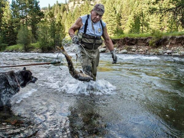
We saw some cool birds on this route including red tailed hawks, sparrow hawks, and owls.
Love Where You Ride! Learn More
![]() Nez Perce Wallowa HomelandIn 1855, the Nez Perce tribe signed a treaty with the US government, which established a reservation for them in what is now Idaho. However, the treaty was later altered by the US government without the tribe’s consent, reducing the reservation’s size and resources. After the Nez Perce War of 1877, the Nez Perce attempted to flee to Canada, covering over 1,000 miles before being captured just short of the border. As punishment, the Nez Perce were forcibly relocated to reservations in Oklahoma and Kansas. In the decades that followed, the tribe worked to regain control of their lands and resources, fighting for the restoration of their treaty rights. In the 1970s, they were successful in regaining some of their lands, including a portion of their ancestral homeland in Oregon’s Wallowa Valley.
Nez Perce Wallowa HomelandIn 1855, the Nez Perce tribe signed a treaty with the US government, which established a reservation for them in what is now Idaho. However, the treaty was later altered by the US government without the tribe’s consent, reducing the reservation’s size and resources. After the Nez Perce War of 1877, the Nez Perce attempted to flee to Canada, covering over 1,000 miles before being captured just short of the border. As punishment, the Nez Perce were forcibly relocated to reservations in Oklahoma and Kansas. In the decades that followed, the tribe worked to regain control of their lands and resources, fighting for the restoration of their treaty rights. In the 1970s, they were successful in regaining some of their lands, including a portion of their ancestral homeland in Oregon’s Wallowa Valley.
Miles 0.4 to 1.2 pass through the Nez Perce Wallowa Homeland. Please be respectful, but more importantly take the time to read the interpretive signs and learn about the history of the people and the lands.
Videos
The Ride! Building Bridges
A quick 2-minute video of what to expect on your ride!
The Nez Perce Last Stand
This 20-minute video explores the compelling history of the Nez Perce Indians and their significant battles against white settlers in the late 1800s. It delves into broken treaties and lost trust, recounting the long marches across the West and the strategic efforts to protect their ancestral [...]
Podcasts
Nez Perce Wallowa Homeland
In this episode of The Connection, we delve into the rich history and cultural significance of the Nez Perce homeland through the insightful perspectives of Katie Harris Murphy, Vice Chair / VP of Board, Wallowa Band Descendant and Joshua Sigmund, Facilities and Grounds Director at the Nez [...]
Untangling the Geological History of the Wallowa Mountains
The Wallowa Mountains in NE Oregon have the most complicated and longest geological history of any range in Oregon. In this podcast, we talk with Dr. Kim Ely, a geologist, about this unique and beautiful area. Learn how to “untangle what you see” when riding in the Wallowas!
Keep it Local! Learn More
Ridden and Reviewed by:


 Behind every route is scouting, mapping, storytelling, and a whole lot of pedal power.
Have you ridden this route? Got a question? Join the discussion!